If the troop is not augmented, it is not capable of performing the following in BUAs:
- Reconnoitering each building and street.
- Reconnoitering underground structures (basements and sewers).
- Determining the strength of dug-in enemy units.
- Determining the detailed disposition of dismounted enemy units.
- Conducting hasty attacks against dismounted enemy units of larger than platoon size.
The following are techniques and considerations for performing reconnaissance in BUAs:
- Dirt roads, alleys, and curves in paved roads are excellent places to employ mines. Structures in BUAs are excellent places to employ booby traps.
- Ask the S2 for detailed street maps of all major BUAs the troop might encounter during an operation. These are more useful than standard 1:50,000 military maps.
- Clearly define platoon zones. Do not divide responsibility for a street between platoons.
- Observe BUAs from outside for signs of enemy activity prior to entering them.
- Main roads through towns are normally accompanied by open areas such as parks, traffic circles, and medians. The enemy may use these same open areas for logistics elements, concentrations of armored vehicles, artillery positions, and combat support vehicle locations.
- Collateral damage constraints may limit the ability to employ some types of weapon systems.
The squadron is conducting a zone reconnaissance. The troop zone contains a large town, 2 to 3 kilometers square, and the squadron main supply route, ROUTE GOLD, passes through the town. The troop will have to reconnoiter enough of the town to ensure there are no enemy who can disrupt movement along ROUTE GOLD.
On approaching the town, the troop has options on how to enter it. The techniques used will largely depend on the amount of time available for the mission. If time is limited, the scouts will halt short of the BUA, just off ROUTE GOLD, and observe the town from multiple vantage points before entering. If more time is available, the scouts will move well off the route and observe the BUA before entering. In any case, remember if enemy is present, he will probably cover the main road with fires. Once the platoon is inside the BUA, the main road may provide the best axis for the reconnaissance.
As the scout platoon observes the town, they look for any signs of enemy presence. The antitank platoons move into overwatch positions. The mortars establish a firing position in support of the scouts. Scouts reconnoiter to the flanks and rear of the BUA to find a bypass and establish flank and far side security (see Figure 3-6).
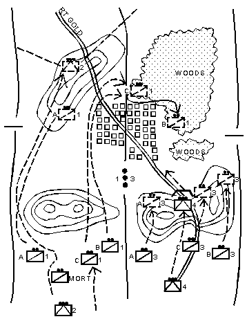 Figure 3-6. The troop securing the BUA with one scout platoon, ATs in overwatch, and one scout platoon preparing to reconnoiter the BUA itself.
Once the area surrounding the BUA is secured, the scouts move mounted to the last concealed position and dismount, searching for suitable entry points into the BUA. If there is enemy contact, the overwatching vehicles suppress with direct and indirect fires while the scouts move to a covered and concealed position. At this point the troop commander must decide to maintain contact and bypass, or continue to probe for entry points into the BUA. The determining factors for the commander's decision are the intent of the higher commander and the level of threat in the BUA. In most instances, cavalry troops maintain contact and bypass BUAs occupied by enemy forces. The enemy forces are handed off to follow-on forces for destruction.
If the troop does not encounter enemy contact on its initial reconnaissance of the outskirts of the BUA, the scout platoons continue their search for suitable entry points into the town. Once the scouts determine those entry points into the town are clear, they move into the BUA and reconnoiter nearby buildings (moving through side and back yards, alleys, and other off-street paths) and surrounding areas. The dismounted teams from the scout platoon do not enter or clear each building, but look for obvious signs of enemy presence. HMMWVs may be brought forward to overwatch the dismounted team's movement with caliber .50 machine guns or MK-19s (see Figure 3-7). The AT platoons should continue to overwatch from outside the BUA. After the scouts complete the reconnaissance of the BUA, the troop continues its reconnaissance in zone, ensuring that bypasses around the BUA are marked.
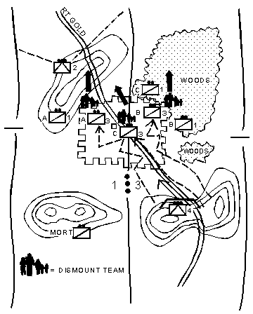 Figure 3-7. Scout section reconnoitering in a built-up area.
Route reconnaissance is a directed effort to gain detailed information about a specific route and the terrain on either side of the route that the enemy could use to influence movement along the route. Depending on the terrain surrounding the route, a route reconnaissance mission may be accomplished by a single scout platoon, or it may require the entire troop to cover the terrain and accomplish the required tasks.
A cavalry troop may be assigned the mission to conduct a zone reconnaissance (see Section IV of this chapter), but also have the task of reconnoitering a route that is within its zone. In this case, the troop mission would be zone reconnaissance. However, one of the subordinate units in the troop, scout platoon, or attached engineers may be given the route reconnaissance mission by the troop commander.
During a route reconnaissance, the following critical tasks must be accomplished unless the SCO directs the troop to do otherwise:
- Reconnoiter and determine trafficability of the route.
- Reconnoiter all terrain the enemy can use to dominate movement along the route.
- Reconnoiter all BUAs along the route.
- Reconnoiter all lateral routes in the area of responsibility.
- Inspect and classify all bridges along the route.
- Locate fords or crossing sites near all bridges along the route.
- Inspect and classify all overpasses, underpasses, and culverts.
- Reconnoiter all defiles along the route; clear all defiles of enemy and obstacles within its capability, or locate a bypass.
- Locate mines, obstacles, and barriers, and within its capability, clear the route.
- Locate a bypass around BUAs, obstacles, and contaminated areas.
- Report route information.
- Find and report all enemy that can influence movement along the route.
The SCO directs the troop to conduct a route reconnaissance as a mission or as a specific task in another mission. This section discusses route reconnaissance in the context of an assigned troop mission.
The troop commander considers several factors in formulating his concept.
- Start point, release point, and designation of the route.
- Mission to be performed at the start point and after reaching the release point.
- Time the mission is to start, and if required, be completed.
- Critical points along the route identified as checkpoints.
- Any constraints or restrictions.
- IPB information on the route, to include current enemy situation.
IPB provides critical information on the enemy and terrain. Enemy threats may be encountered in two basic forms.
- Ambushes along the route in close or restricted terrain or even tied to obstacles along the route.
- Attack by long-range direct or indirect fires from dominating terrain along the route.
Analysis of the terrain provides an indication of danger areas and the nature of the potential threat. From this information, the commander determines how much terrain on each flank of the route must be reconnoitered and the organization for combat. Any constraints or restrictions may also influence how much terrain is reconnoitered.
The troop commander adds control measures to provide an adequate framework for the mission. He places a boundary on both sides of the route far enough out to provide reconnaissance of the dominating terrain. A line of departure is placed perpendicular to the route short of the start point, allowing sufficient space to deploy into a tactical formation. An LOA is placed far enough beyond the release point to enclose dominating terrain that overwatches the release point. The commander uses additional phase lines to maintain a coordinated effort throughout the troop. Boundaries and phase lines are drawn along recognizable terrain features. The terrain features should be visible from both ground and air to facilitate air-ground integration. The commander uses other control measures as necessary for flexibility in the maneuver and execution of the mission (see Figure 3-8).
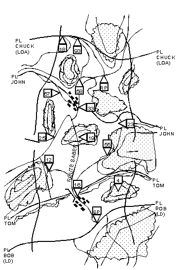
Figure 3-8. Troop graphic control measures for a route reconnaissance.
The cavalry troop normally performs a tactical road march to the line of departure and deploys to execute the reconnaissance of the route. Based on the amount of intelligence known about the enemy, the commander will determine how much security is required for the move forward to the line of departure. Also the commander should consider the effect his final disposition of forces will have on the troop's follow-on mission.
One technique for accomplishing all tasks as rapidly and safely as possible is as follows: Draw a 2.5-kilometer to 3-kilometer boundary on either side of the route. Near the start point, draw a line of departure from one boundary to the other. Next, draw an LOA about 3 kilometers forward of the release point from one boundary to the other. Add phase lines between the line of departure and LOA, as needed, to help control the progress of the troop. To control movement on the route, establish checkpoints. Use checkpoints to identify specific areas or locations to be reconnoitered. These checkpoints will serve as references to orient reconnaissance efforts.
One scout platoon moves out early across the line of departure to reconnoiter the terrain or BUAs on either side of the route. The other scout platoon reconnoiters the route itself, trailing 1 kilometer to 2 kilometers behind the lead scout platoon. This provides a good measure of security for the troop and the platoon working to reconnoiter and classify the route. The mortar section follows the lead scout platoon and remains positioned to range from 3,000 to 3,500 meters forward of the lead scout elements. The mortar section avoids moving on the route and stays on the flanks near the route. The tank/AT platoons follow and support behind the second scout platoon. They key their movement on the advance of the scout platoons. The tank/AT platoons should be kept back in depth to retain flexibility, because they must be ready to react anywhere in the troop zone. The troop trains follow about 2 kilometers behind the tank/AT platoons, and bound from one covered and concealed position to another. The troop CP displaces generally along the route using terrain that affords effective and continuous communications with troop elements and the squadron. The troop commander positions himself to observe the actions of the scout platoons.
The 1st platoon (scout) crosses the LD (PL BOB) using the two-section organization, and reconnoiters the terrain on either side of ROUTE SABER up to PL TOM. The platoon looks for the threat around the outskirts of the village, and explores routes into the village that intersect ROUTE SABER. The scouts also search the woods near checkpoint 4 for the enemy. The platoon scans the terrain north of the stream, and then moves up. One section locates a fording site west of the bridge at checkpoint 16, and the other section swims the stream on the east. The platoon makes a quick visual inspection of the bridge, then searches for the threat in the forested terrain near checkpoints 12 and 55. The mortar section crosses the LD next, about 2 kilometers behind the 1st platoon (scout), and establishes a firing position on the outskirts of the village. The 3d platoon (scout) crosses the SP when the 1st platoon (scout) crosses PL TOM.
The 3d platoon (scout) reconnoiters and classifies the route through the village, then moves up and classifies the bridge just north of town. The troop commander bounds closely behind the 3d platoon (scout) and observes their actions. The 2d and 4th platoons (tank) follow along the flank of ROUTE SABER about 1 kilometer behind the 3d platoon (scout), then move into the outskirts of the village. They observe the dominating terrain on the far side of the stream while the 3d platoon (scout) reconnoiters the bridge. The troop CP and trains remain in concealed positions south of the LD (see Figure 3-9).
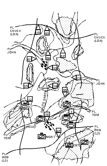
Figure 3-9. Route reconnaissance (part one).
The 1st platoon continues to reconnoiter in zone up to PL JOHN. The platoon searches the wooded areas for the threat, and explores the high-speed lateral routes to the east and west of ROUTE SABER. The platoon clears the shoulders and makes a visual inspection of the defile on ROUTE SABER at checkpoint 19, then moves forward to search the outskirts of the village at checkpoint 33. As with the first village, the platoon looks for threat forces along the roads into the village. The mortar section follows the 1st platoon and establishes a firing position on the edge of the woods southwest of checkpoint 19. The 3d platoon continues classifying the route along ROUTE SABER. At the defile near checkpoint 19, scouts using mine detectors check the route to ensure it is free of mines. The 2d and 4th platoons cross the bridge at checkpoint 16, and then move into concealed positions in the woods on either side of ROUTE SABER near checkpoint 19. The troop CP moves to a concealed position on high ground near checkpoint 12. The troop trains move into covered and concealed positions in the village south of checkpoint 16 (see Figure 3-10).
As the 1st platoon crosses PL JOHN and approaches the RP, the lead scout squad of Bravo section is hit by cannon and heavy machine-gun fire from concealed positions near checkpoint 93. The vehicle has its left track blown off and sustains external damage. The gunner and one scout are wounded by shell fragments. The PSG immediately returns fire and deploys to cover then reports the contact to the platoon leader who forwards a contact report to the troop commander. Once the PSG determines the location of the enemy force, he sends a spot report to the platoon leader and a request for immediate suppression to the troop FSO. After the call for fire is sent forward, the PSG directs his remaining scout squad to search for additional threat forces in the woods north of the RP and along the high-speed route heading northeast (see Figure 3-11). As mortar fire falls on the enemy position, the 1st platoon leader quickly moves up near checkpoint 58 to observe the threat. He directs his section to search the woods north of checkpoint 57, and to move around to the west flank of the threat and find out
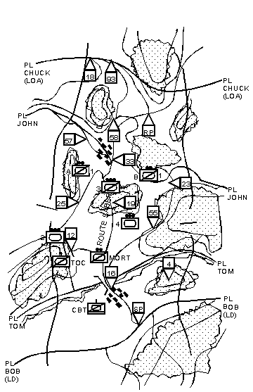 Figure 3-10. Route reconnaissance (part two).
Choose your next action:
Continue Chapter 3
Return to FM 17-97 Table of Contents
|
NEWSLETTER
|
|
Join the GlobalSecurity.org mailing list
|
|
|

