 Figure 3-11. Route reconnaissance (part three).
what the platoon is up against and whether or not the threat force is supported by other elements in the village at checkpoint 18. He then reports to the troop commander. The troop commander immediately moves forward to join the 1st platoon leader and to see the situation for himself. En route, the commander tells the 2d and 4th platoons to move into concealed positions in the village at checkpoint 33, and to prepare to counterattack. The 3d platoon continues to reconnoiter the route through the village at checkpoint 33, and then moves into covered positions along ROUTE SABER just south of checkpoint 33. The troop CP holds in place and reports the situation to squadron. The 1SG quickly leads the M88 and the medic vehicle forward to treat and evacuate the injured scouts and their damaged vehicle.
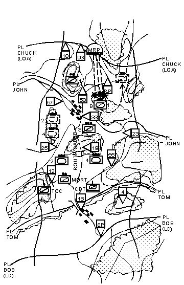
Dismounted scouts from the 1st platoon determine that the threat force consists of three BMPs and one T-64 in prepared positions. Threat crews remain mounted and continue to slew turrets, scanning for more friendly elements. The threat reinforced platoon is oriented southeast toward the route. Their western flank is free of obstacles and unobserved. The troop commander decides to conduct a hasty attack (see Figure 3-12).
When the tank platoons complete their hasty attack, the troop commander gets permission to advance beyond the LOA and reconnoiter the enemy position. The 3d platoon returns to complete the reconnaissance of ROUTE SABER. As the platoon checks for mines along the route to the RP, they discover the route is mined just short of the RP. They find a bypass around the obstacle and forward a bypass report (Blue 10) to the troop XO. The platoon then organizes into two sections and moves out to occupy OPs overlooking the lateral routes at the east and west flanks of the troop near PL CHUCK. The troop CP moves into position on high ground near checkpoint 58. The 1SG directs activities of the troop trains, to include evacuation of injured soldiers and inoperable vehicles, security and evacuation of injured prisoners, requests for casualty replacements and resupply.
 Figure 3-12. Route reconnaissance (part four).
Zone reconnaissance is the directed effort to obtain detailed information concerning all routes, obstacles, terrain, and enemy forces within a zone defined by boundaries. Obstacles include chemical and radiological contamination. A zone reconnaissance is assigned when the enemy situation is vague or when information concerning cross-country trafficability is desired. It is appropriate when previous knowledge of the terrain is limited or when combat operations have altered the terrain.
CRITICAL TASKS
Zone reconnaissance is a deliberate, time-consuming process. During a zone reconnaissance, the troop accomplishes the following critical tasks unless specifically directed otherwise by the higher commander:
- Reconnoiter all terrain within the zone.
- Inspect and classify all bridges within the zone.
- Locate fords or crossing sites near all bridges in the zone.
- Inspect and classify all overpasses, underpasses, and culverts.
- Locate and clear all mines, obstacles, and barriers in the zone within its capability.
- Locate a bypass around BUAs, obstacles, and contaminated areas.
- Find and report all enemy forces within the zone.
- Report reconnaissance information.
TECHNIQUES
The cavalry troop is usually assigned a zone reconnaissance as part of a squadron zone reconnaissance mission.
A zone reconnaissance mission is very time-consuming. Any commander who orders this mission must remember the number and complexity of the tasks to be accomplished. If he wants a faster tempo, he must prioritize reconnaissance tasks for the troop.
The cavalry troop can effectively reconnoiter a zone from 6 to 10 kilometers wide. If stretched any farther, the troop quickly exceeds its ability to accomplish the critical tasks.
Because the enemy situation is vague and knowledge of the terrain is limited to what is shown on maps or aerial photos, platoons will face unexpected situations around every corner; therefore, the course of action selected must also provide a good measure of protection for the troop as it executes the mission. When considering techniques of conducting a zone reconnaissance, the scheme of maneuver has to be flexible. The troop commander must convey his intent to subordinates so they can act quickly and without orders. He should employ forces, tank or AT platoons, in depth to give the troop flexibility and responsiveness.
When the troop receives a zone reconnaissance mission, the zone is usually identified by lateral boundaries. The line of departure and a reconnaissance objective or LOA are specified. The commander should divide the troop zone into two platoon zones for the scout platoons. Use caution when drawing the boundary. Make sure it is on easily identifiable terrain that is not a high speed avenue of approach. The number of critical tasks within the troop zone, and terrain restrictions should guide the commander in determining the location of the scout platoon boundaries. Doctrinal distances are not always the best solution if one platoon will be overtasked.
Add phase lines every 5 to 8 kilometers on easily identifiable terrain to control progress of the troop through the zone. Place contact points near the intersection of the boundary and all phase lines. Ensure the contact points provide at a minimum the potential for concealment from enemy observation to allow the exchange of information between flank units. Use checkpoints to focus the efforts of scout platoons and to assist in maneuvering the troop (see Figure 3-13). Use TIRS on maps as described in Chapter 2.
Use a troop vee or split-vee to conduct zone reconnaissance. As scout platoons reconnoiter the zone, the tank/AT platoons follow and support behind the scouts, keying their movement off the scouts' forward progress. The tank/AT platoons are kept far enough in depth to retain flexibility, and yet remain responsive to situations developed by the scout platoons. The distance from the scouts is determined by the terrain and enemy situation. Therefore, the distance the tanks/ATs move from the scouts may vary during the course of the operation. Control tank/AT platoon movement by one of the following methods:
- Give movement guidance to the platoon leaders. Have them key movement off the scouts.
- Move the platoons by CPs, battle positions, and hide positions.
Move the mortar section center of the troop zone to range forward of the scouts. The range forward of the scouts is determined by the scouts' ability to acquire the enemy. The mortars may move under the control of the FIST or eavesdrop on the troop net and key their movement off the progress of the scout platoons. Regardless of who controls their movement, the TOC and the FIST track the mortar position constantly to ensure they can support the scouts.
Note. If the mortar section is busy firing missions and computing fire data, they may not be able to stay abreast of the friendly situation. Therefore, the FIST or XO should be ready to control the mortars displacement.
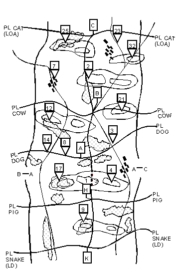
Figure 3-13. Zone reconnaissance graphic control measures.
The XO displaces the troop CP through the zone using terrain that affords effective and continuous communications with troop elements and the squadron. The 1SG moves the troop trains about 2 kilometers behind the tank platoons and bounds the trains from one covered and concealed position to another. The troop commander positions himself well forward to observe the actions of one scout platoon or the other. His position usually depends on where he expects initial enemy contact or problems to occur.
LIGHT TROOP EXAMPLE
The troop commander deploys the troop in a split-vee formation. The 1st and 3d platoons (scout) cross the LD, PL UTAH, abreast and reconnoiter the terrain in troop zone up to PL OHIO. The platoons determine both the open terrain and the trafficability of the route within their zone. Some hill slopes are greater than thirty percent and dense woods inhibit armor movement. Except for a marshy area north of checkpoint 9, the open terrain is dry and firm. Both routes will support heavy armor movement. The troop commander follows the 1st platoon. The mortar section eavesdrops on the troop command net to follow the progress of the scout platoons, and coordinates its moves with the troop FSO accordingly. As the scout platoons cross PL OHIO, the 2d and 4th platoons (antitank) cross the LD. They eavesdrop on the troop command net and key their movement on the progress of the scout platoons. The troop CP and the trains hold in place.
The scout platoons continue reconnaissance up to the river (PL BAMA). They take a close look at the dominant terrain near checkpoint 17 and at the village near checkpoint 4. As the platoons approach the river, scouts move into covered and concealed positions, dismount, and visually search the dominant terrain on the north side of the river. The 1st platoon inspects the bridge at checkpoint 14 and determines that it will support up to 40 tons. Scouts also verify that a good fording site exists near checkpoint 8. The 3d platoon confirms there is a fording site with a rock bottom just east of the blown bridge at checkpoint 3. It will support heavy armored traffic (see Figure 3-14).
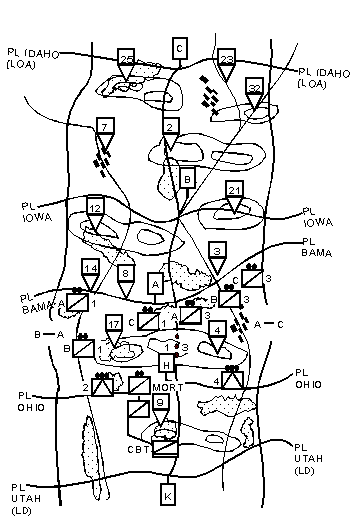 Figure 3-14. Zone reconnaissance (part one).
As the scout platoons continue reconnaissance towards PL IOWA, the 1st platoon observes two stationary BRDM-2s on the high ground near checkpoint 12. They look like a security outpost. The platoon engages with immediate suppression from the troop's 120-mm mortars. As the rounds impact, the outpost withdraws behind the ridgeline to the north. The 3d platoon determines the dominant terrain near checkpoint 21 is clear of threat forces. The mortar section crosses the river at checkpoint 8. The 2d platoon follows, crossing at checkpoint 8, while the 4th platoon uses the ford near checkpoint 3. The troop CP bounds forward to high ground near checkpoint 17. The troop trains cross the river and move into the woods on the northern bank.
The scout platoons continue reconnaissance while moving toward the troop LOA. As the 3d platoon crosses the ridge (PL IOWA), Bravo section receives heavy machine-gun fire from concealed positions south of checkpoint 2. The platoon immediately deploys, reports contact to the troop commander, and calls for indirect fire to suppress the threat (see Figure 3-15).
Under this protection, the platoon, using primarily a dismounted technique, reconnoiters to the flanks and rear to develop the situation. The troop commander acknowledges the report, and moves immediately to link up with the 3d platoon leader. The troop commander orders the 1st platoon to continue its reconnaissance to locate the enemy's flank and coordinate with the FIST to switch indirect fires to the squadron howitzer battery. The 3d platoon is organized in a three-section, three-vehicle configuration; the platoon leader is with the Charlie section. The platoon leader sends his Bravo section forward on the enemy's left and his Alpha section on the right to determine if the enemy is mutually supported by other threat forces from the flanks or rear. The Charlie section sergeant and a two-man dismount team move in closer and determine that the enemy consists of an MRP with three BTR 70s and one BMP-2. The Alpha scout section and scouts from 1st platoon identify the right flank of the threat and discover the flank is unprotected by obstacles and is exposed to direct fires.
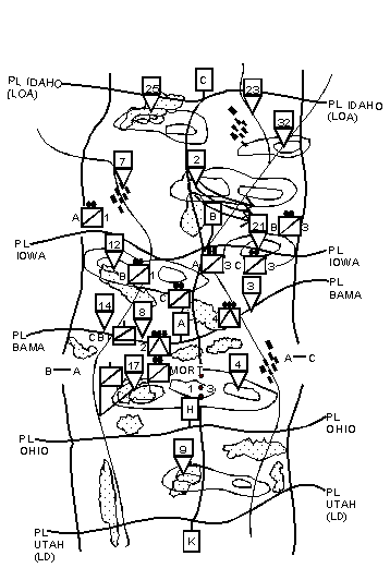 Figure 3-15. Zone reconnaissance (part two).
While en route to the 3d platoon's zone, the troop commander tells the 1st platoon to continue reconnaissance forward to PL IDAHO and determine if other enemy forces are providing mutual support to the enemy in the 3d platoon's zone. At PL IDAHO, he tells the platoon to establish a screen. The troop commander tells the 4th platoon to move over and join the 3d platoon Charlie section in overwatch of the enemy MRP, and prepare to overwatch with fires. The troop commander tells 2d platoon to prepare to conduct a hasty attack of the enemy MRP. The 1st platoon scout squad moves to checkpoint 12, links up with the 2d platoon, and guides them into position to attack the threat platoon.
The 2d platoon reports they are set in the assault position. The 4th platoon reports they are set in the overwatch position with the 3d platoon Charlie section. The 3d platoon leader reports that his dismount teams from his Alpha and Bravo sections are out of the target area and set. The 1st platoon leader reports he is set in a screen along PL IDAHO. The troop commander orders the FSO to fire for effect on the enemy position at his command. The commander issues orders and guidance for limits of fire and signals for the initiation, shifting, and lifting of fires. The troop commander issues the fire command for indirect fire over the command net and follows with a fire command for direct fire for the 4th platoon and the Charlie section of 3d platoon. The indirect fire from the squadron's howitzer battery and the troop mortars impact on the enemy position and is immediately followed by the fire from four TOWs, MK-19s, and M2 machine guns. The commander then issues the orders for 2d platoon to initiate its move to the attack-by-fire position followed by the order for the support element (4th platoon, Charlie section of 3d platoon) to shift fires. The troop FSO shifts fires to the rear of the enemy position. The 2d platoon moves forward and engages the enemy target from the flank to complete the destruction of the enemy force (see Figure 3-16).
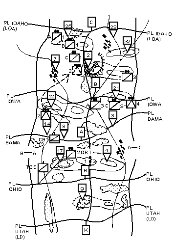 Figure 3-16. Zone reconnaissance (part three).
The antitank platoons consolidate in covered and concealed positions west of checkpoint 2. Scout dismount teams from the 3d platoon move in quickly, capture two wounded prisoners, and search the vehicles and personnel. The 3d platoon leader orders one scout squad to stay and secure the prisoners, and then completes his reconnaissance up to the LOA. The 1SG leads the medics to the location of the 3d platoon scout squad and the EPWs. The XO collects and transmits final reconnaissance reports to the squadron.
AIR-GROUND COORDINATION
Cavalry troops will often conduct a coordinated reconnaissance with an air cavalry troop. Because of the air cavalry troop's ability to maneuver faster and look deeper than ground cavalry, they are often placed to the flanks or forward of ground cavalry. The air cavalry troop should focus its reconnaissance efforts on areas that impede ground cavalry movement.
The air cavalry troop quickens the pace or tempo of the ground reconnaissance because it provides the ground unit with added security during movement and increased situational awareness once contact is made. The air cavalry troop can gain initial contact with the enemy or a critical piece of terrain. Once the air troop develops the situation with his assets, he can pass off the information/contact to the ground troop (see Figure 3-17).
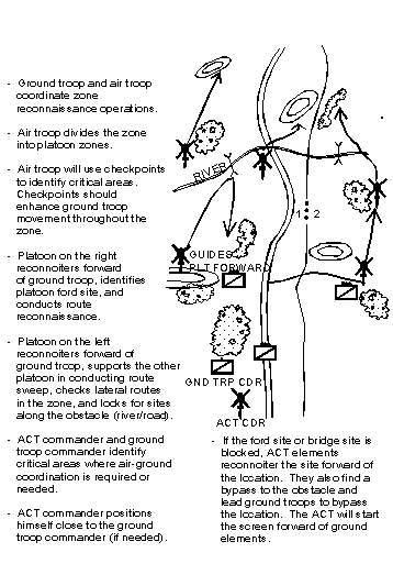 Figure 3-17. Air-Ground troop coordinated reconnaissance.
An area reconnaissance is a specialized form of zone reconnaissance. It is a mission conducted to gain detailed information about terrain features and enemy forces within a specified area or point that other forces intend to occupy, pass through, or avoid. A commander usually calls for area reconnaissance before he sends his forces into or near an area to avoid being surprised by actual terrain conditions or unexpected enemy forces.
CRITICAL TASKS
During an area reconnaissance, the following critical tasks must be accomplished unless the SCO directs the troop to do otherwise:
- Reconnoiter all terrain within the area.
- Inspect and classify all bridges within the area.
- Locate fords or crossing sites near all bridges within the area.
- Inspect and classify all overpasses, underpasses, and culverts.
- Locate and clear all mines, obstacles, and barriers in the area within its capability.
- Locate a bypass around BUAs, obstacles, and contaminated areas.
- Find and report all enemy within the area.
- Report reconnaissance information.
TECHNIQUES
An area reconnaissance is conducted like a zone reconnaissance. When the troop receives an area reconnaissance mission, the assigned area is identified as the terrain inside a solid, continuous boundary. Planning the movement to the area is the first step. Select the route(s), establish a march order on each route, and specify a start point, checkpoints, and a release point. Use a movement technique that keeps the troop moving quickly and securely. If possible, avoid contact with the enemy while en route. Report and bypass. Be careful when approaching the area to begin the reconnaissance. Use common sense. Avoid known enemy forces outside of the area where reconnaissance will be conducted; start somewhere else.
As in a zone reconnaissance, enclose the area within a troop zone. Draw a line of departure, an LOA, and lateral boundaries. Divide the troop zone into two platoon zones. Add phase lines along identifiable terrain to control movement through the area. Place contact points at the intersection of the platoon boundary and all phase lines. Place TIRS on the map. To identify specific areas or features, use checkpoints for reference (see Figure 3-18).
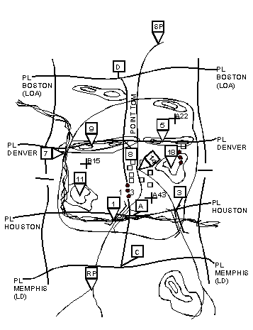 Figure 3-18. Area reconnaissance.
Use a troop vee or split-vee to conduct an area reconnaissance. Scout platoons deploy abreast from the release points to accomplish all the reconnaissance tasks. They move out across the line of departure first. The mortar section moves through the center of the troop zone, remaining in position to range from 3 to 3.5 kilometers forward of the lead elements in the scout platoons. The mortar section could also follow one of the scout platoons, depending on where initial enemy contact is expected. The tank platoons are kept back far enough in depth to retain flexibility, but remain responsive to situations developed by the scout platoons. They key their advance on the progress of the scout platoons. The tank platoons are told how far behind the scout platoons they should stay as the troop deploys across the line of departure. The distance between the tank platoons and the scout platoons will usually be adjusted as the terrain or enemy situation changes. The troop CP displaces through the zone using terrain that affords effective and continuous communication with troop elements and squadron. The troop trains follow about 2 kilometers behind the tank platoons and bound from one covered position to another. The troop commander positions himself well forward to observe the action of one scout platoon or the other. The location usually depends on where initial enemy contact or problem situations are expected.
Choose your next action:
Go to Chapter 4
Return to FM 17-97 Table of Contents
|
NEWSLETTER
|
|
Join the GlobalSecurity.org mailing list
|
|
|

