

|
RDL Homepage |
Table of Contents |
Document Information |
Download Instructions |
LESSON 2
HASTY PROTECTIVE ROW MINEFIELD
Critical Task: 051-192-3032
OVERVIEW
LESSON DESCRIPTION:
This lesson discusses the procedures used to emplace, record, and remove a hasty protective row minefield. Part A provides basic information on the procedures and requirements for emplacing and recording a hasty protective row minefield. Part B provides basic information on the procedures for removing a hasty protective row minefield.
TERMINAL LEARNING OBJECTIVE:
| ACTION: | You will learn to identify the requirements and describe the procedures used to emplace, record, and remove a hasty protective row minefield. |
| CONDITION: | You will be given the material contained in this lesson. |
| STANDARD: | You will correctly answer all practice-exercise questions at the end of this lesson. |
| REFERENCE: | The material contained in this lesson was derived from FM 20-32. |
INTRODUCTION
Hasty protective row minefields are temporary in nature and are used as part of a unit's defensive perimeter. Units usually lay hasty protective row minefields using mines from their basic load.
PART A - EMPLACING AND RECORDING A HASTY PROTECTIVE ROW MINEFIELD
2-1. General. If time permits, mines are buried to increase their effectiveness; but they may be surface-laid. Minefield recovery is easy because antihandling devices (AHDs), nonmetallic mines, and low-metallic mines are not used. Employ mines outside the hand-grenade range but within the range of small caliber weapons. Unless the minefield is being transferred to a relieving commander, the emplacing unit will pick up all mines (unless enemy pressure prevents mine retrieval) upon leaving the area.
2-2. Rules. The brigade commander has the initial authority to employ hasty protective row minefields. This authority may be delegated to the battalion or company commander. Marking rules are the same for hasty protective row minefields as for other row minefields. A summary of those rules is shown below:
- Rows.
— Rows are marked and recorded. Designate each row with a capital letter (A, B, and so forth) with Row A being closest to the enemy.
— The minimum distance between AT mine rows is 8 meters.
— The distance between the start row marker and the first mine in a row is the mine spacing for that row.
— An IOE row is not used.
— Start and end row markers are permanent markers and must be made of detectable material.
- General.
— The spacing between mines is at least 4 meters to prevent sympathetic detonation. There is no maximum distance between mines within a row.
— Mines are at least 15 meters from the perimeter fence.
— The minefield has at least one landmark that is located to the rear, never to the extreme side or front.
— The minefield has an easily identifiable reference point (RP) (tree, stump, stake).
— Back azimuths are not used to record the minefield.
— Measurements are recorded in meters.
— AHDs, nonmetallic mines, or low-metallic mines are not used.
— Hasty protective row minefields are recorded on DA Form 1355-1-R (Figure 2-1).

Figure 2-1. Sample DA Form 1355-1-R
2-3. Site Layout.
a. Requesting and receiving permission to lay mines is the first step when emplacing a hasty protective row minefield. Conducting a thorough leader's reconnaissance of the proposed minefield area is next. Mine locations that cover likely avenues of approach (AAs), enhance key weapon systems, and cover dead space are identified. Establish an easily identifiable RP between the minefield and the unit's position. After the reconnaissance, mines are emplaced but not armed. From the RP, visualize the mines as running in rows parallel to the unit position (Figure 2-2). After establishing a RP and visualizing the minefield, complete a record and emplace the mines concurrently. This procedure simplifies recording and makes retrieval quicker and safer.
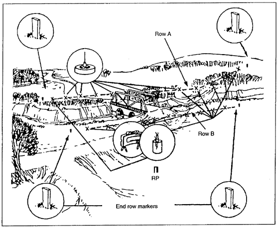
Figure 2-2. Site layout
b. Designate the row closest to the enemy as Row A; designate succeeding rows as B, C, D, and so on. Show the ends of rows by two end row markers. Label them with the letter of the row and the number 1 for the right end of the row or the number 2 for the left end of the row. Number the rows from right to left facing the enemy. The marker should be an easily identifiable object, such as a wooden stake with a nail or a steel picket, so that it can be found with the AN/PSS-12 mine detector.
2-4. Emplacement and Recording Procedures.
a. From the RP, the NCOIC measures the magnetic azimuth in degrees to a selected point on the right side (facing the enemy) of the tentative minefield. Pace off the distance and record it in meters. Identify the measurement method in the remarks block on a DA Form 1355-1-R (for example, pace out distances and multiply by 0.75 to convert the measurement to meters). This point, called B1 (if there are two rows), marks the beginning of the second row. Place a marker at B1 and record the azimuth and the distance on DA Form 1355-1-R ( Figure 2-3).
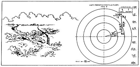
Figure 2-3. Hasty protective row minefield record
b. From B1, the NCOIC measures the azimuth and distance to a second point on the right side of the minefield (facing the enemy). Place a marker at this point and record it as Al.
c. The NCOIC measures and records the distance and azimuth from Al to the location of the first mine in that row. The distance from the end row marker to the first mine is the distance between all mines in that row. After recording the location, the mine is emplaced but not armed.
d. The NCOIC measures the azimuth and the distance from the first mine to the second, and so on, until all mines are emplaced and the locations are recorded. Repeat this procedure for the second row.
e. As each mine is recorded, the NCOIC assigns it a number to identify it in the minefield record. When the last mine location is recorded for a row, measure the azimuth and the distance from that point to another arbitrary point, A2 or B2. Place a marker here in the same manner as Al and B1. Next, record the distance and the azimuth from the RP to B2 and from B2 to A2.
f. When all the mines have been placed and recorded, the NCOIC measures the azimuth and the distance between the RP and a permanent landmark that can be found on the map. Record this information on DA Form 1355-1-R. The landmark is used to assist others in locating the minefield if it is transferred or unexpectedly abandoned.
h. If the minefield is transferred to another unit, the gaining unit leader is briefed by the transferring unit leader. The gaining unit leader signs and dates the mines-transferred block on the DA Form 1355-1-R. Destroy the form when the minefield is removed. If the minefield is abandoned unexpectedly, forward the DA Form 1355-1-R to higher headquarters.
PART B - REMOVING A HASTY PROTECTIVE ROW MINEFIELD
2-5. General. Before removing mines, the NCOIC must first determine which of the following two methods to use:
- If the minefield has been under constant observation from the time it was laid and has not been tampered with, the NCOIC directs the personnel who laid the mines to pick up the same mines. Use DA Form 1355-1-R, preceded by a mine detector, to determine the types of mines to be removed and where they are located.
- If the minefield has not been under constant observation, may have been tampered with, or the personnel who laid the mines are not available (or do not remember the location of the mines), the NCOIC uses DA Form 1355-1-R and a clearance team (outlined in FM 20-32) to locate and remove mines.
2-6. Removal Procedures.
a. The NCOIC retrieves the safety clips, shipping plugs, and any other items that accompanied the emplaced mines.
- Check the sides and bottoms for AHDs and then disarm or mark the mines.
- Replace all pins, clips, or other safety devices before the mine is removed from the ground.
- Turn any arming dials to SAFE or UNARMED; or if the mine has a screw-type fuse, remove the fuse and take it away from the mine.
— If the mine was placed and kept in sight by the individual who removes it, lift it directly from the hole after rendering it safe.
— If the mine has not been kept in sight, attach a 60-meter-long rope or wire around the mine, take cover, and pull the mine from the hole.
- Place a tick mark beside each mine on the DA Form 1355-1-R as it is removed.
- Assemble all the mines in one location for accountability.
NOTE: AHDs are not used in hasty protective row minefields. However, as a safety precaution, consider all mines to be equipped with AHDs until proven otherwise.
d. The NCOIC confirms the removal of the mines and accounts for the number of mines, by type, as recorded on the DA Form 1355-1-R. The NCOIC may find it necessary to confirm an exploded mine to account for all the mines. To confirm a mine explosion that was not witnessed, identify the crater or traces of burnt soil made by the detonated mine. Place a tick mark beside the mine number on the DA Form 1355-1-R. Make sure any craters found in the vicinity of a mine were caused by a land mine and not by artillery. A mine crater (depending on the mine's size) is normally shallow and circular and shows burnt-soil traces. The impact and soil dispersion of artillery is generally elongated.
GO TO: