

Houston
2005 Hurricane Rita
| Satellite Imagery of Houston, TX | ||
| 2005 Hurricane Rita | ||
|---|---|---|
| !!! Please do not hotlink the images !!! | ||
Hurricane Rita
|
Hurricane Katrina
|
|
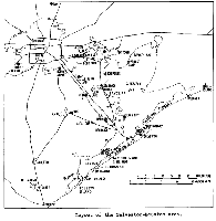 Map of the Galveston-Houston Area [Click on image for larger version] |
||
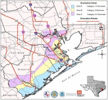 Map of Houston Evacuation Plan [Click on image for larger version] |
 Satellite image of Hurricane Rita, as of Sept. 22, 2005 [Click on image for larger version] |
|
|
|
|
|
|
|
|
|
|

|
NEWSLETTER
|
| Join the GlobalSecurity.org mailing list |
|
|
|