

FM 34-81-1: Battlefield Weather Effects
CHAPTER TWO
WEATHER ELEMENTS AND SUPPORT
A working knowledge of various weather elements identified here is essential to your ability to provide your commander with a complete picture of potential adverse weather effects on the battlefield. But, you are not alone in your mission. Help is available from a variety of sources.
INTERACTION OF BATTLEFIELD ENVIRONMENT ELEMENTS
Weather conditions, terrain, BIC, illumination, and background signatures are some of the primary conditions that will be found in a battlefield environment. Table 2-1 defines some of the more common weather elements discussed.
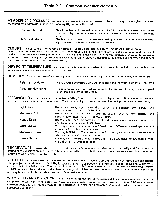
A weather element generally is an atmospheric variable that is measured in a weather observation. A weather parameter is derived from one or more weather elements. For example: density altitude is a weather parameter derived from the elements barometric pressure and temperature.
You must remember that weather conditions such as wind, precipitation, and clouds can impact or can be influenced by the other conditions of the battlefield (terrain, BIC, illumination, and background signatures). All of these conditions are interdependent to a certain degree and must be considered as a whole, and not each in isolation.
WEATHER EFFECTS AND TERRAIN
Terrain features affect such weather elements as visibility, temperature, humidity, precipitation, winds, and clouds. The most common example of terrain affecting weather is that on the windward side of high terrain, such as mountains, the rainfall rate will be greater than on the leeward (opposite) side.
On the other hand, weather conditions such as temperature, winds, and precipitation have a definite effect on the terrain and can enhance or limit military operations, such as trafficability, watercrossing (fording), and the first-round accuracy of supporting field artillery fires. The responsibility for determining mobility and counter-mobility is given to the terrain team at division.
Examples of terrain products that are normally prepared and available from the division terrain analysis team for use in the intelligence preparation of the battlefield (IPB) are discussed later in this chapter in the terrain analysis team support section.
BATTLEFIELD-INDUCED CONTAMINANTS
During combat operations, visibility can become severely reduced by BIC. These contaminants are either induced directly by combatants or occur as by-products from battlefield operations.
Two significant sources of battlefield contaminants are dust produced by high explosive (HE) artillery or mortar rounds and deliberately employed smoke. HE rounds used in a pre-attack barrage may not only kill enemy forces, but also may restrict the visibility of your own troops by dust caused by the HE if the direction of the wind is not taken into account. Smoke produced by smoke generators, vehicle exhaust emission systems, smoke pots, indirect fire, and smoke rounds also obviously produce battlefield contaminants.
Wind speed and direction are critical to maintaining an effective smoke screen. Rain can remove BIC quickly. Weather inversions over valley areas can sustain airborne contaminants for long periods of time.
Other sources of BIC that will lower visibility in the AO are clouds of dust from vehicle traffic or smoke from fires. These types of contaminants not only blind you but also may help your adversary in detecting troop movements and pinpointing your location.
A unique BIC, affecting visibility, occurs in very cold conditions when temperatures are in the range of -30° C or -22° F or colder. Whenever a source of moisture or water vapor is released into the cold air by internal combustion engines, artillery fires, or launching of self-propelled munitions, visibility can be reduced to zero when the moisture freezes instantly and changes into ice fog.
Ice fog may restrict visibility across a whole valley and, once created, can linger for hours. Ice fog crystals permit ground objects to be seen from above while severely restricting visibility on the ground--an advantage for aerial reconnaissance.
On airfields an ice fog created by fixed-wing aircraft may cover an entire runway. Visibility can be reduced so that other aircraft cannot take off or land if the wind is calm. Besides reducing visibility, the ice fog draws attention to the airfield location.
Launching missiles such as the tube-launched, optically tracked, wire-guided (TOW) in very cold air can create an ice fog. As the TOW moves to the target, the exhaust blast exits into the air where it condenses and creates the ice fog. If the wind is calm, this fog follows the trajectory of the missile and reduces launch point visibility to such an extent that the operator loses sight of the target. Also, the launch point can be identified by threat forces from the condensation trail of the missile.
ILLUMINATION
Natural light is critical in planning operations where night vision devices (NVD) are used or in operations timed to use only available light. Natural light values vary as a function of the position of the sun, moon, stars, and clouds. Light data are available from your SWO for any time, period, and place. These data are particularly important for determining first and last light, moonrise, and moonset, and are most effective for planning use of NVD.
Appendix F provides more detail on the impact of illumination on electro-optical (E-O) devices. Variables such as altitude, cloud cover, terrain-produced shadows, visibility, and direction of vehicle or aircraft movement in relation to the sun or the moon can also affect light level availability.
Artificial light is intended to increase visibility, but, under certain weather conditions, this does not always occur. For example: Low cloud ceilings will limit the area covered and effective time of flares. Rain, snow, or fog can reduce flare effectiveness. However, under the right conditions, cloud cover can enhance the effects of artificial light due to cloud base reflection. Snow or sand covered terrain also reflect both natural and artificial light.
BACKGROUND SIGNATURES
Temperature, wind, and precipitation have a major influence on your ability to pick out a target from the background in the infrared spectrum. They also affect seismic (sound and acoustic) signatures. Detection of objects in the infrared spectrum depends on a temperature contrast between the object and its surrounding environment. This difference is known as the background signature.
A more detailed explanation on how the background signature is affected and changed by weather is also in Appendix F. Snow, rain, and wind influence the background signature because they can change the surface temperature of objects. These elements lower object temperatures and thus reduce the differential between a target and its background.
A heavy layer of snow produces a washout during any part of the day since it causes both the object and the background to exhibit the same temperature.
Precipitation also degrades seismic sensors through the introduction of background noise (rain), while a snow-covered surface will dampen sound and the movement of troops.
OTHER WEATHER PHENOMENA
Although we have discussed such elements as clouds, temperature, and precipitation, other phenomena should not be overlooked. For example: In the desert, strong winds produce dust storms that can last for hours or even days.
Any wind, during cold weather, causes loss of heat from the body and increases the danger of freezing. This is discussed in Appendix L. Thunderstorms, with their associated lightning, strong winds, and heavy rains affect the battlefield environment. Owing to their short-lived ferocity and unpredictability over a given time and location, thunderstorms are difficult to assess in planning. But when they occur, they definitely disrupt intelligence gathering and affect personnel movement, equipment function, and target identification.
Atmospheric pressure is essential information for aircraft operations. High humidity and temperature affect aircraft lift and significantly reduce a soldier's ability to work and fight.
WEATHER PRODUCTS
There are four types of weather information products that are available:
- Weather Observations.
- Weather Forecasts (to include severe weather warnings).
- Climatology.
- WTDAs.
All of these products are vital in preparing a complete weather picture of the battlefield, and showing critical weather impacts on your unit's systems and operations.
WEATHER OBSERVATIONS
There are two types of weather observations normally collected on the battlefield: surface and upper air. Surface weather observations are taken by both Army and USAF personnel. Army intelligence personnel take weather observations under the Forward Area Limited Observing Program (FALOP) as outlined in FM 34-81/AFM 105-4.
Participating Army personnel (usually someone on your staff) will be taking a limited number of abbreviated surface observations, using a small, manual belt weather kit (BWK). The BWK is scheduled for replacement by an automated meteorological sensor system.
WETMs take and disseminate hourly observations as well as special observations when critical changes occur. Weather observations within the division AO might be available from a USAF mobile observing team (MOT). The MOTs are organic to the division WETM and are deployed at the direction of the SWO after coordination with the G2. If the G2 decides against employing a MOT below the division main command post (CP), the only immediate source of weather observations at the maneuver brigade and battalion are from the FALOP.
Regardless of the source of weather observations, they reflect current --conditions and could be used, if the weather is stable, as an indicator for up to 1 to 3 hours. Remember that as the quality and quantity of observations diminish, their value, as even near-term trend indicators, also diminishes.
It is the Army's responsibility to provide upper-air data to support field artillery as needed. These upper-air observations may be taken as frequently as every 2 hours, or only twice daily. Field artillery meteorological (ARTYMET) sections also take valuable limited surface observations. Upper-air data primarily supports field artillery operations, but other mission areas use it routinely. These surface and upper-air meteorological messages should be quickly transmitted to WETMs. The WETM combines the ATYMET data with other meteorological information to support aviation, NBC, engineers, and other consumers.
WEATHER FORECASTS
Weather forecasts are prepared by WETM forecasters and normally cover periods from 1 hour out to 48. Outlooks extend from 3 days to 7 days. Several factors determine the accuracy of the forecast. These factors include--
- The length of time in advance that the forecast is required.
- The area for which the forecast is made.
- The quality and quantity of weather observations available to the forecaster.
- The quality and availability of communications.
- The availability of USAF-provided weather data base.
Forecast accuracy normally diminishes as the forecast period increases. A 24-hour forecast is more accurate than a 72-hour outlook. Although extended outlooks may not predict cloud base heights or exactly when the rain will start, they can show expected movement of weather systems with associated cloud and precipitation areas.
Forecasts and extended outlooks are the building blocks you use to determine the effect of the weather on planning. The shorter time period and the greater the number of observations in the forecast area, the higher the confidence you can have in the accuracy of your analysis.
CLIMATOLOGY
Weather information required beyond the extended outlook (7 days) is based upon historical climatological data. This information is important for long-range planning, especially if you are to deploy to an unfamiliar AO. Climatology data gives the commander average weather conditions and the weather extremes that can be expected in the field. This assists in planning--
- Future operations.
- Types of systems, equipment, and supplies.
- Personnel strengths.
You will need to work with your SWO while still in garrison to collect and process climatology data.
SOURCES OF WEATHER SUPPORT
Weather support to Army tactical units is provided in two ways. The WETMs provide all forecasts and supplemental weather information received from national and local sources, together with surface observations taken at each WETM location. Some division WETM MOTs may be deployed forward (by direction of the division commander) to supplement surface observations taken by Army personnel. The Army is responsible for taking surface and upper-air observations forward of the division command element and in direct support of Army weapon systems and operations.
USAF TACTICAL WEATHER SUPPORT
FM 34-81/AFM 105-3 states Army doctrine and our requirement for weather support. The USAF Directorate of Weather assigns weather forecasters and observers, comprising WETMs, or special operations weather teams (SOWTs), to tactical Army units to meet this need.
USAF forecasters are at the main CP at-
- Echelons above corps (EAC).
- Corps. Divisions.
- Separate brigades.
- ACRs.
- Division and corps aviation brigades.
- Ranger regiments.
- SFG headquarters and forward operating bases (FOBs).
Observers are assigned to the same locations listed above and assist forecasters by taking surface weather observations. Limited observing functions may exist at the SFGs, FOBs, and ranger regiments. MOTs may also be deployed to selected tactical airfields and landing zones (LZs). Size and composition of WETMs vary from as few as 4 observers and forecasters to teams with as many as 14 observers and forecasters plus 2 officers.
At EAC, corps, and division the senior weather officer is the tactical unit's SWO. Although the SWO is a member of the special staff, he normally works with the G2 and with the operations and plans sections. The SWO commands all the WETMs at his tactical level and is under the operational control of the Army commander.
Each SWO ensures that his WETM supports the commander's needs. For this reason, it is important that you outline your specific requirements to your supporting SWO. Weather support requirements must be validated (by the SWO and the SIO) prior to deployment so that the WETM can make the necessary preparations. If new requirements surface in the field, or changes are required, you notify your SWO. Give him enough lead time to allow for production changes.
ARMY WEATHER SUPPORT
By joint regulation, AR 115-10/AFR 105-3, USAF responsibility for surface weather observations ends at the division main CP. The Army's responsibility is take observations from the CP forward, and in direct support of Army weapons systems anywhere in the AO.
As discussed earlier, the FALOP and ARTYMET data partially satisfy this to requirement. Weather satellite imagery will play a larger role as new systems are designed to capture this data.
HOW G2 OR S2 RECEIVE WEATHER SUPPORT
It is your responsibility to provide weather and weather effects information to your commander and supported or subordinate units. Methods may vary from unit to unit and echelon to echelon. At higher echelons, the SWO has primary responsibility for providing weather support. There, the G2 simply contacts the SWO, states requirements, and receives the needed weather support.
If you have no SWO, you must pass the request up the chain of command to a level where one is assigned. Once your requirements have been validated, weather support products flow back over the same path. In addition to weather forecast products, the SWO can provide specialized weather effects products. You must provide the threshold values used in developing these products.
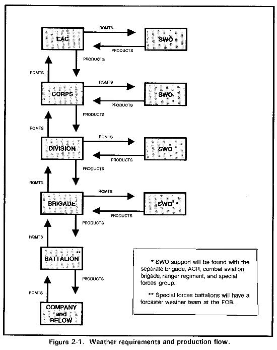
Figure 2-1 summarizes this flow. The SWO support to the brigade is shown with an asterisk because only separate and aviation brigades have direct weather support.
TERRAIN ANALYSIS TEAM SUPPORT
Combat intelligence is composed of weather, enemy, and terrain; sometimes called the WET trilogy. Below division, where a terrain team is not assigned, the intelligence analyst working order of battle (OB) has the added responsibility for terrain analysis. Your OB specialist relays the unit's requirements, through channels, to the terrain team supporting the division. He also does whatever limited local analysis is needed.
Once in the field, terrain and weather analyses in support of the intelligence preparation of the battlefield (IPB) are based on locally updated terrain data bases and the current weather forecast for the AO.
Terrain teams are responsible for analyzing the division geographic AI and providing recommended courses of action based upon effects of weather under current and forecast weather conditions. They produce graphical tactical decision aids (TDAs) that help the commander and staff understand the effects of weather on division operations. These IPB templates are available to you at either brigade or battalion upon request.
The principal user of IPB templates is the divisional G2 staff, but terrain teams will service needs of brigade and battalion S2s as priorities allow.
Separate brigades and other corps or EAC units obtain the same support via the corps or theater G2. Lead time must allow production of tailored products, and attached elements can expect to compete with other G2 and engineer priorities.
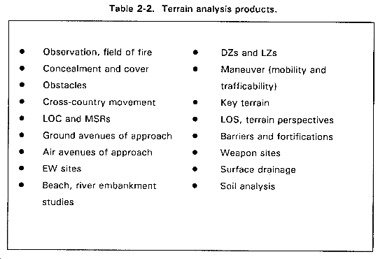
Many standard products will already be available from the division's team. See Table 2-2. The more you exercise terrain teams, the more responsive they will be as they understand and learn to anticipate the needs of brigades and battalions.
In the field, new or updated terrain analysis products may be obtained electronically or via courier.
USE OF INTELLIGENCE PREPARATION OF THE BATTLEFIELD TEMPLATES
IPB templates provide an integrated graphic portrayal of enemy doctrine and the effects of weather and terrain in the AO and AI. Development of IPB products, while still in garrison, based on climatology (provided locally by the WETM) gives you a general idea of what average seasonal weather conditions will be in the AO.
Once deployed, IPB products must be updated based on--
- Current weather observations.
- Periodic weather forecasts.
- Environmental effects products produced by the terrain team.
By comparing the weather forecasts or current observations to the climatology used in preparing the IPB templates, you can keep the commander informed on trends.
Two examples illustrate how garrison-prepared IPB products can be updated in the field. You have prepared IPB templates depicting mobility or countermobility based on a climatic average of 2 inches of precipitation. Then the SWO reports that the rates are higher than anticipated. You quickly modify the templates and brief the commander.
Then, if you have prepared air mobility corridor templates based on the general low-level cloud ceilings (climatology) and high mountainous terrain, these can be modified to determine the best and worst air corridors based on either weather observations or forecasts.
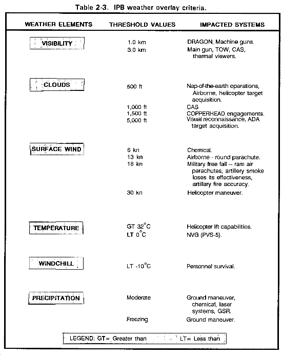
You can obtain weather IPB overlays by asking for them from your higher G2. The G2 will then task the SWO to produce the weather portion of the overlays. Overlays may be used with either climatology for long-range planning or with forecasts for a specific time. Combinations of several critical threshold values and weather elements may be depicted on one overlay. This way a specific weapon systems effectiveness can be briefed as a sum of the various weather elements involved.
Remember that for long-range planning a climatology review and data extraction is a time-consuming process. The more lead time you can give the G2 and the SWO, the more thorough the research and the higher quality of the finished product. Use Appendixes B through O as guides to develop weather overlays. The weather elements contained in Table 2-3 may not address all of your unit's weather needs. Other weather overlays that may be of interest are--
- Atmospheric pressure and density altitude for helicopters.
- Areas where thermal sight target signatures will be reduced.
- Time periods when thermal crossover will occur.
- Areas where heat and humidity will exceed mission oriented protective posture (MOPP) 4 survivability for time periods over 2 hours at hard work.
- Long-range surveillance unit (LRSU) high altitude, high opening (HAHO) infiltration corridors based on upper-air weather conditions.
- Weapon system performance capabilities based on combined weather effects threshold values.
By combining climatology, terrain data, and the IPB process while still in garrison, you get an idea of what to expect in the field. Then you use current forecasts and local terrain data to update the weather and terrain analysis steps of IPB.
|
NEWSLETTER
|
| Join the GlobalSecurity.org mailing list |
|
|
|