


Modern Defensive Readiness and Technology Center
| Satellite Imagery of the Modern Defensive Readiness and Technology Center |
||
| Click on the small image to view a larger version | ||
 CIA Map depicting the location of Tehran |
 Landsat 7 imagery of Tehran as of 18 July 2000 (Source: Earth Science Data Interface) |
|
 Map of NE Tehran (Source: NCRI Briefing Slide, 17-Nov-04) |
 Image of NE Tehran (Source: NCRI Briefing Slide, 17-Nov-04) |
|
| Comparative Close-Up of Main AOI of the MDRTC | ||
|---|---|---|
Click on Image for Comparative View |
||
 Overview of the NE Tehran (Source: DigitalGlobe, 16-Nov-04) |
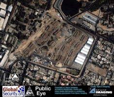
Overview of MDRTC and immediate surronding areas (Source: DigitalGlobe, 16-Nov-04) |
|
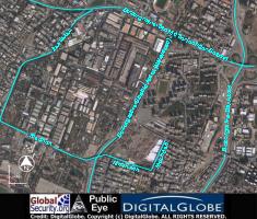
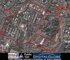
Major streets around the MDRTC and immediate surronding areas (Source: DigitalGlobe, 16-Nov-04) |
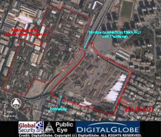
Close-up of the Main AOI and additional Revetted Area in Pasdaran (Source: DigitalGlobe, 16-Nov-04) |
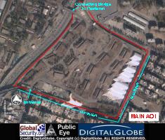
Close-up of the Main AOI (Source: DigitalGlobe, 16-Nov-04) |
|
NEWSLETTER
|
| Join the GlobalSecurity.org mailing list |
|
|
|