


5.8 VISUAL RESOURCES
This section describes the impacts of the TWRS alternatives on the visual resources of the Hanford Site and vicinity, focusing primarily on potential impacts from offsite locations. The visual impacts of all TWRS alternatives would result from developing the facilities associated with waste retrieval, processing, and storage activities, and from borrow site activities associated with implementing the alternatives.
As described in Section 4.8, the Hanford Site landscape is characterized primarily by its broad plateau (Section 4.8). This visual setting provides for sweeping vistas of the area broken up by more than a dozen large Hanford Site facilities (e.g., processing plants and nuclear reactors) located around the Hanford Site. Only 6 percent of the Hanford Sites total area has been used for industrial activities. The 200 Areas, where virtually all proposed TWRS activities except for borrow site use would occur under all alternatives, currently contain three large processing facilities (the Plutonium-Uranium Extraction [PUREX] Plant in the 200 East Area and B Plant and U Plant in the 200 West Area) as well as the 18 tank farms that contain the tank waste and numerous multi-story support facilities.
The potential Pit 30 borrow site, which would provide sand and gravel as part of implementing all EIS tank waste alternatives except No Action and Long-Term Management, is located between the 200 East and 200 West Areas. The potential Vernita Quarry and McGee Ranch borrow sites, which would be used (if selected and approved) under all tank waste alternatives except No Action and Long-Term Management for closure-related activities, are located in undeveloped areas approximately 6 km (4 mi) north and west of the 200 West Area.
The following text summarizes the potential impacts to visual resources under each of the EIS alternatives.
No Action Alternative (Tank Waste)
Under the No Action alternative, impacts would be largely limited to continuing existing visual disturbance from ongoing use of the tank farms. No additional facilities would be constructed, and routine tank farm operations would continue in their current form.
Long-Term Management Alternative
This alternative would have the same visual impacts as the No Action (Tank Waste) alternative (continuation of existing visual disturbance) until new replacement storage tanks were developed to replace the existing DSTs. In the 2030's and again in the 2080's, 26 additional underground tanks would be built to replace the existing tanks that would reach the end of their design lives. The new tanks would be constructed in a previously disturbed area of the 200 East Area about 180 by 150 m (600 by 500 ft). The new tank farms would not be visible from any offsite locations because they would be in the interior of the Hanford Site, and most of the facilities would be underground. The new tank farms would, however, be visible from elevated locations on the Site (Gable Mountain, Gable Butte, and Rattlesnake Mountain) that are used by Native Americans for religious purposes. The Confederated Tribes of the Umatilla Indian Reservation have expressed the concern that visibility of new TWRS facilities under this and virtually all other alternatives except No Action would represent an adverse impact on these religious sites (CTUIR 1996).
In Situ Fill and Cap Alternative
The In Situ Fill and Cap alternative would not develop any new treatment facilities in the 200 Areas. However, Hanford Barriers would be developed over each of the tank farm sites. Visually, the Hanford Barriers, which would be associated with the closure scenario, would resemble a 4.5-m (15-ft) soil mound with sloping sides covered with soil and vegetation. Because of this low visual profile, impacts would be minor. There would be no visual impacts from any offsite locations, including the Columbia River.
Borrow site activities would leave a topographic depression at each of the three potential borrow sites for this alternative, as well as for all other tank waste alternatives except No Action and Long-Term Management. While such topographic changes would be visually inconsistent with the surrounding landforms, there would be limited viewing opportunities from offsite. The potential Pit 30 borrow site is in the interior of the Hanford Site and could not be seen from offsite except from elevated locations. Borrow site impacts associated with closure are described to provide a basis for comparing the impacts of this EIS. The potential Vernita Quarry borrow site would be expanded to support TWRS project closure activities. The past quarry operations site is highly visible from State Route 24, and the expansion area also would be highly visible from the highway. The potential McGee Ranch borrow site would be located near State Route 24. The borrow activities would be visible to travelers on State Route 24 traveling east-west just west of the Yakima Barricade, and travelers on State Route 24 after it turns north-south at the Yakima Barricade.
In Situ Vitrification Alternative
The primary visual feature of the In Situ Vitrification alternative would be the large confinement structures that would be erected over each tank farm during operations (Figure 3.4.5). A tank farm confinement structure would enclose an entire tank farm, reaching a maximum abovegrade height of 30 to 45 m (100 to 150 ft). There would be one tank farm confinement structure in operation and two tank farm confinement structures under construction at any one time over the 18-year period between 1998 and 2016.
The number of tank farm confinement structures would increase steadily as activities proceeded under this alternative, eventually reaching a total of 18 such structures (one for each tank farm). Decontamination and decommissioning of all tank farm confinement structures would occur when vitrification was completed at the last tank farm. After 2016, the structures would be removed and their visual impact would be eliminated.
Each in situ vitrification facility would have one 30-m (100-ft)-high stack and a number of support facilities, none of which would be more than one to two stories high. There also would be power line segments installed to provide electrical power to the in situ vitrification operations at each tank farm. After the waste vitrification activities at the tank farms were complete, each tank farm would be covered with a Hanford Barrier.
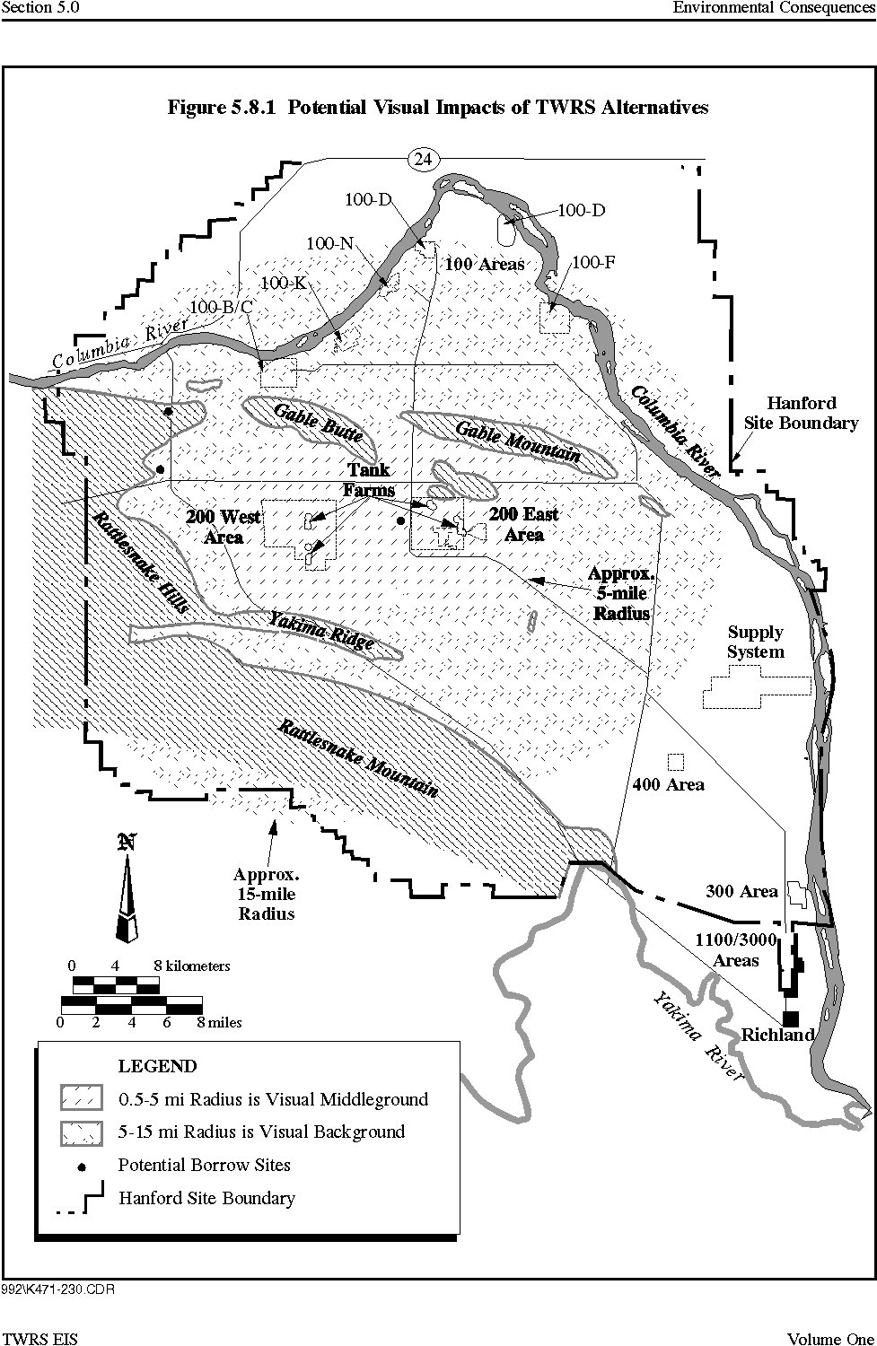
Figure 5.8.1 illustrates the alternative's potential visual impacts. The tank farm confinement structures would be visible from several kilometers away and each would resemble a large industrial building with an exposed steel arch roof structure. They would be visible along an approximately 11-km (7-mi) segment of State Route 240 to the south and east of the 200 Areas. Travelers on State Route 240 would see the confinement structures in the 200 West Area tank farms as part of the visual middleground, defined as 0.8 to 8 km (0.5 to 5 mi) away. Offsite viewing would be of moderate visual intrusiveness because the TWRS sites would be relatively similar to other industrial facilities currently existing at the Hanford Site. Tank farm confinement structures in the 200 East Area would be visible in the visual background (more than 8 km [5 mi] away). Vitrification operations would not be expected to produce any stack plumes that would be visible from offsite locations.
Figure 5.8.1 Potential Visual Impacts of TWRS Alternatives
Post-remediation Hanford Barriers would have minimal visual impacts from any offsite locations because of their low visual profiles and the distances involved. None of the facilities (including the tank farm confinement structures) would be expected to be visible from offsite locations other than State Route 240. The facilities would be visible from elevated locations such as Gable Mountain, Gable Butte, and Rattlesnake Mountain, but would not be visible from the Columbia River.
Borrow site impacts essentially would be the same as for the In Situ Fill and Cap alternative: borrow activities and the resulting land form changes would be highly visible at the potential Vernita Quarry borrow site from State Route 24, visible at the potential McGee Ranch borrow site from State Route 24, and not visible from public roadways at the potential Pit 30 borrow site . All activities at the potential borrow sites would be visible from elevated locations such as Gable Mountain, Gable Butte, and Rattlesnake Mountain.
Ex Situ Intermediate Separations Alternative
This alternative would require two large facilities, both located in the same portion of the 200 East Area. These would be a HLW vitrification facility reaching 30 m (100 ft) abovegrade, and a LAW vitrification facility reaching 19 m (63 ft) abovegrade. Each plant would have two 55-m (180-ft)-high stacks. The two large vitrification facilities with their 55-m (180-ft)-high stacks occasionally might be visible in the visual background from State Route 240 (Figure 5.8.1). Because of the distance involved, visual impacts would be minor and similar to the impacts that currently exist. Plumes from the vitrification facility stacks might be visible occasionally from locations near the Site boundaries under certain atmospheric conditions (e.g., high humidity and no wind). The LAW vaults and tank farms would not be visible from State Route 240 because of their size (no more than the equivalent of one to two stories high) and the distances involved. None of the TWRS sites would be expected to be visible from any other offsite locations, including the Columbia River. However, the facilities would be visible from elevated locations such as Gable Mountain, Gable Butte, and Rattlesnake Mountain.
As part of the closure scenario, there also would be Hanford Barriers over the tank farms and LAW disposal vaults. Borrow site impacts would be the same as described for the In Situ Vitrification alternative, high at the potential Vernita Quarry and McGee Ranch borrow sites , and low at the potential Pit 30 borrow site .
Ex Situ No Separations Alternative
The remedial activities of the Ex Situ No Separations alternative would result in similar impacts to the Ex Situ Intermediate Separations alternative. There would be only one large stack because there would be only one vitrification facility. This stack would be briefly visible in the visual background by travelers on State Route 240 and facilities would be visible from elevated locations . Plumes from the vitrification facility stack might be visible from locations near Site boundaries under certain atmospheric conditions. Because there would be no onsite LAW disposal vaults, closure would require fewer Hanford Barriers. Visual impacts at the potential borrow sites resulting from their use to support closure would be the same as described for the other tank waste alternatives.
Ex Situ Extensive Separations Alternative
The remediation actions under this alternative would result in essentially the same visual impacts as described earlier for the Ex Situ Intermediate Separations alternative. Visual impacts would result from two large vitrification facilities of the same height as described previously, both with 55-m (180-ft)-high stacks. Closure impacts would include the Hanford Barriers over the tank farms and LAW disposal vaults, and land form changes at the potential borrow sites and disposal vaults.
The two vitrification facilities occasionally would be visible in the visual background from State Route 240, and all facilities would be visible from elevated locations. No facilities would be visible from the Columbia River. Plumes from the vitrification facility stacks could be visible occasionally near the Hanford Site boundaries on days with certain atmospheric conditions (e.g., high humidity and no wind).
Ex Situ/In Situ Combination 1 and 2 Alternatives
These alternatives would have essentially the same visual impacts as described for the Ex Situ Intermediate Separations alternative. Changes to the visual environment would occur at facility sites during remediation and at Hanford Barriers and the potential borrow sites during closure.
Phased Implementation Alternative
Phase 1
Phase 1 of the Phased Implementation alternative would have similar visual impacts to the other ex situ alternatives. The primary visual impact would be from 46-m (150-ft)-high stacks on each vitrification facility, although the overall complex would be smaller than the other ex situ alternatives. The vitrification facility stacks occasionally would be visible from State Route 240, and under certain atmospheric conditions, plumes from the stack might be visible from near Site boundaries. The Phased Implementation facilities would be visible from elevated locations. No facilities would be visible from the Columbia River. Phase 1 of Phased Implementation would involve no onsite LAW disposal vaults. The only borrow site visual impacts would be from the disturbance of 0.4 ha (1 ac) at the potential Pit 30 borrow site.
Total Alternative
The Phased Implementation alternative, when fully implemented, would include the impacts detailed for Phase 1 as well as impacts associated with the second phase of the alternative. The additional visual impacts would include two large vitrification tactics with their stacks. All other impacts would be similar to those of the Ex Situ Intermediate Separations alternative.
Capsule Alternatives
All cesium and strontium capsule alternatives except Onsite Disposal would have negligible visual impacts because no activities would be visible from offsite locations. The No Action alternative would involve continued use of the current WESF site. The Onsite Disposal alternative would involve using a disturbed site adjacent to the 200 East Area and facilities but would have 672 1.2-m (4-ft)-high cement caps over each of the drywells, which would be visible from elevated locations. The Overpack and Ship and Vitrify with Tank Waste alternatives would require small facilities that would be sited within the large TWRS sites proposed for the 200 East Area under the various ex situ alternatives. These capsule facilities would not be noticeable within the complex.
|
NEWSLETTER
|
| Join the GlobalSecurity.org mailing list |
|
|
|