


4.0 AFFECTED ENVIRONMENT
This section provides a summary description of the existing environment that could be impacted by the Tank Waste Remediation System (TWRS) activities at the Hanford Site. More detailed descriptions of environmental baseline conditions are provided in Volume Five, Appendix I of this Environmental Impact Statement (EIS), in the Hanford Site National Environmental Policy Act Characterization Report (Cushing 1994 and 1995 and Neitzel 1996 ), in the Hanford Site Environmental Report for Calendar Years 1994 and 1995 , (PNL 1995 and 1996 ), and in the Site Evaluation Report for Candidate Basalt Quarry Sites (Duranceau 1995). All information contained in this section is from these sources unless otherwise noted.
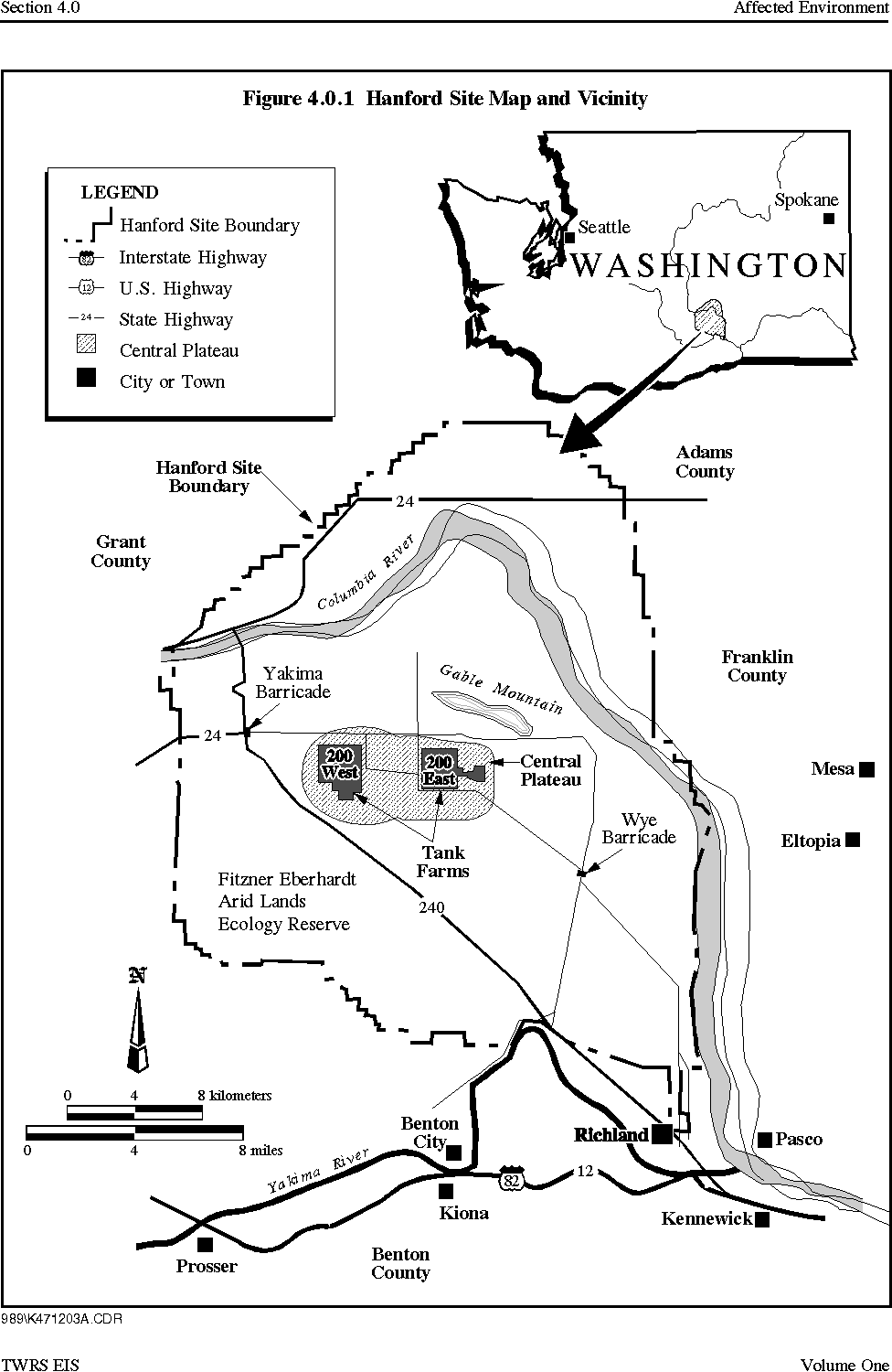
The Hanford Site is in the semi-arid region of the Columbia Plateau in southeastern Washington State (Figure 4.0.1). The Hanford Site occupies about 1,450 square kilometers (km2) (560 square miles [mi2]) of shrub-steppe and grasslands just north of Richland, Washington. The majority of this large land area, with restricted public access, provides a buffer to the smaller areas within the Hanford Site historically used for producing nuclear materials, waste storage, and waste disposal. About 6 percent of the land has been disturbed and is actively used. The Hanford Site extends approximately 77 kilometers (km) (48 miles [mi]) north to south and 61 km (38 mi) east to west.
The Columbia River flows through the northern part of the Hanford Site, turning south to form part of its eastern boundary. The Yakima River runs along part of the southern boundary and joins the Columbia River within the city of Richland. Adjoining lands to the west, north, and east are principally range and agricultural land. The cities of Richland, Kennewick, and Pasco (also known as the Tri-Cities) comprise the nearest population centers and are located southeast of the Site.
Figure 4.0.1 Hanford Site Map and Vicinity
4.1 GEOLOGY
The geology section, which provides an overview of the Hanford Site's subsurface environment, focuses primarily on the 200 Areas, which are located in the center of the Site. With the exception of two potential borrow sites found approximately 6.5 km (4 mi) to the north and west of the 200 Areas and a third potential borrow site located between the 200 East and 200 West Areas, the 200 Areas would be the location of virtually all TWRS activities under all tank waste and cesium and strontium capsule alternatives. The section describes Hanford Site topography, geologic structure, stratigraphy, soil, and seismicity (including earthquake history). Reports by Delaney (Delaney et al. 1991), Reidel (Reidel et al. 1992), and Cushing (Cushing 1994), summarize information collected in various earlier Hanford Site projects and are the primary basis for the material presented.
4.1.1 Topography
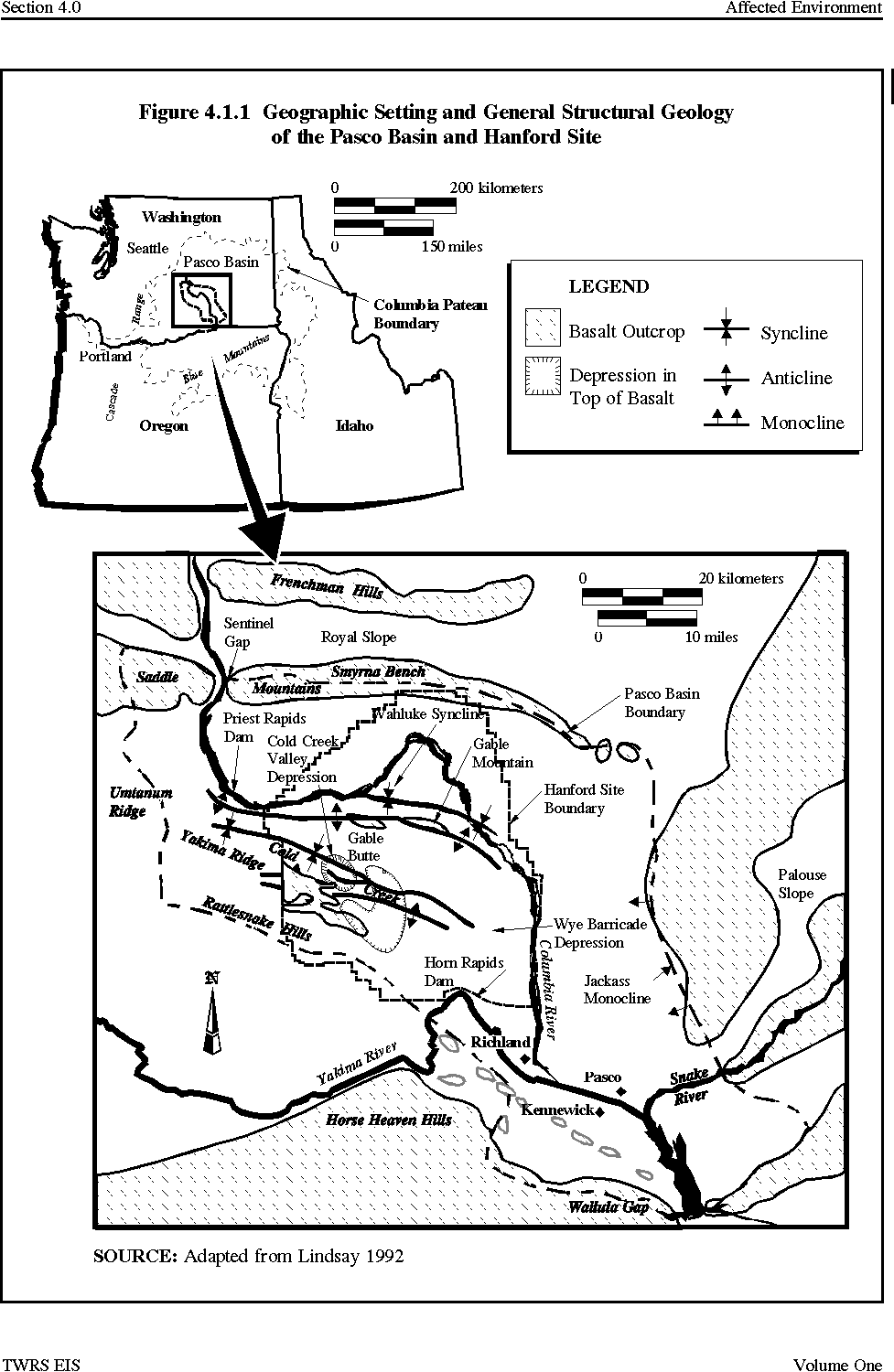
The TWRS sites are located on and near a broad flat area of the Hanford Site commonly referred to as the Central Plateau. The Central Plateau is within the Pasco Basin, a topographic and structural depression in the southwest corner of the Columbia Basin, characterized by generally low-relief hills with deeply incised river drainage (Figure 4.1.1). The Hanford Site is an area of generally low relief, ranging from 120 meters (m) (390 feet [ft]) above mean sea level at the Columbia River to 230 m (750 ft) above mean sea level in the vicinity of the TWRS sites.
Geologic processes that alter topography include landslides, floods, and volcanic activity. Landslides are not a common occurrence in the 200 Areas because of flat topography, the deep water table, and the absence of any actively eroding streams. The nearest potential flooding source to the TWRS sites is Cold Creek, located in the southwest portion of the Hanford Site. Studies of the probable maximum flood show its effect would be limited to the southwestern corner of the 200 West Area (Cushing 1994). The potential McGee Ranch and Vernita Quarry borrow sites, possible sources of rip rap (Vernita) and silt (McGee) for post-remediation surface barrier construction, are located in the northwest corner of the Hanford Site and are not within the probable maximum flood area (Figure 3.6.1) (Cushing 1994). The third potential borrow site (Pit 30) is located on the Central Plateau between the 200 East and 200 West Areas and is well removed from potential flooding sources. The only likely source of volcanic activity that could impact the TWRS sites would be volcanism in the Cascade Mountain Range more than 100 km (60 mi) west of the Hanford Site. The 1980 eruption of Mount St. Helens is an example of such a volcanic event. This eruption caused ashfalls at the Site but had no other effect.
Figure 4.1.1 Geographic Setting and General Structural Geology of the Pasco Basin and Hanford Site
4.1.2 Geologic Structure
The Hanford Site lies in the Pasco Basin near the eastern boundary of the Yakima Fold Belt. The Pasco Basin is bounded by anticlinal ridges on the north, west, and south. A monocline bounds the east. The Pasco Basin is divided by the Gable Mountain anticline, and the Wahluke syncline to the north and the Cold Creek syncline to the south.
The 200 Areas are situated between the Gable Mountain anticline and the Cold Creek syncline. The Gable Mountain anticline is of particular importance to the groundwater flow. Portions of this anticline have been uplifted to a point where basalt is above the current water table (Figure 4.1.1). These basalts have a low hydraulic conductivity and act as a barrier to horizontal groundwater flow in the unconfined aquifer.
4.1.3 Stratigraphy
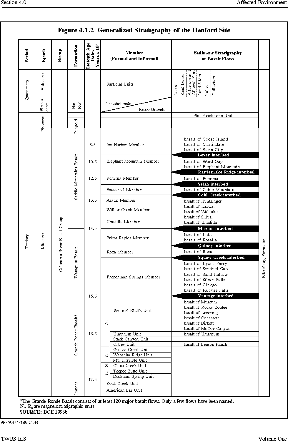
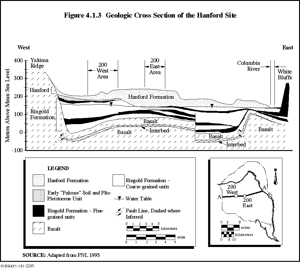
Hanford Site stratigraphy is summarized in Figure 4.1.2. A generalized west to east cross-section depicting the Site's structure and topography is shown as Figure 4.1.3. Basalt flows more than 3,000 m (10,000 ft) thick, called the Columbia River Basalt Group, lie beneath the Hanford Site. Interbedded between many of these basalt flows is the Ellensburg Formation, a series of sand, gravel, or silt layers deposited by the ancestral Clearwater and Columbia rivers. The stratigraphy beneath the Hanford Site is described in the following paragraphs in ascending order, from the deepest formation directly overlying the Columbia River Basalt Group upward to the ground surface.
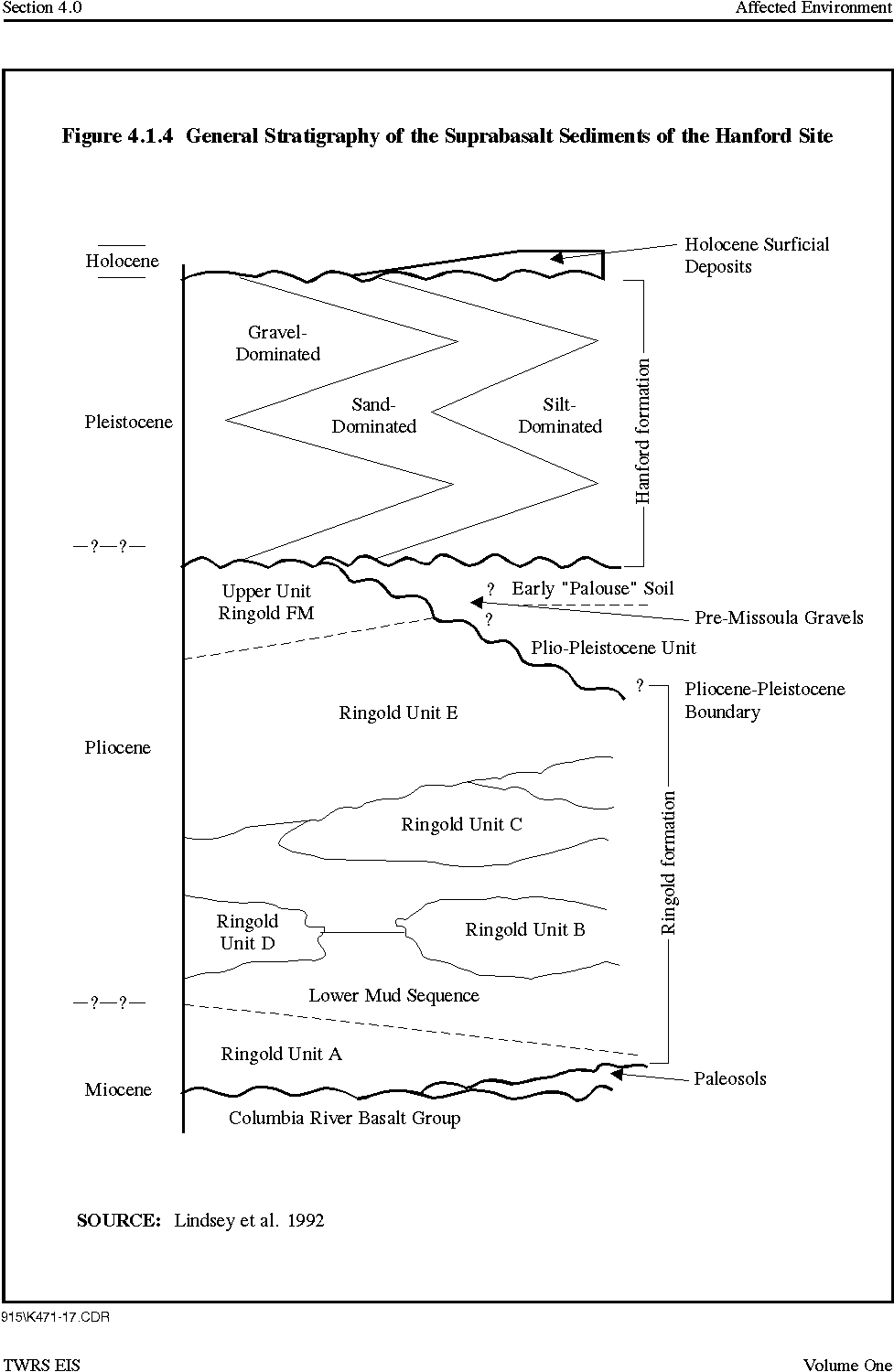
The suprabasalt sediments are a sedimentary sequence up to 230 m (750 ft) thick overlying the Columbia River Basalt Group, and include the Ringold and Hanford Formations.
Thin, laterally discontinuous alluvial deposits, referred to as the Plio-Pleistocene unit, pre-Missoula gravels, and early Palouse soil, separate the Ringold Formation from the overlying Hanford Formation in various parts of the Hanford Site. Alluvial deposits are sediments deposited by flowing water. Of particular note is the Plio-Pleistocene Unit, which in the TWRS project vicinity is generally restricted to the 200 West Area. Depending on location, two types of material may be present in the Plio-Pleistocene unit. It may consist either of carbonate-cemented silt (locally referred to as a caliche layer) interfingered with sand and gravel, or of carbonate-poor silt and sand interfingered with basaltic material, sand and gravel, or both (Trent 1992a).
Figure 4.1.2 Generalized Stratigraphy of the Hanford Site
Figure 4.1.3 Geologic Cross Section of the Hanford Site
The Ringold Formation consists of clay, silt, fine-to coarse grained sand, and gravel. The Ringold Formation is up to 180 m (600 ft) thick south of the 200 West Area, but is largely absent in the northern and northeastern portions of the 200 East Area and adjacent areas to the north. The Ringold Formation is delineated by five different kinds of sediments, associated with fluvial (river-related) sands and gravels, floodplain and lake deposits, and alluvial fan deposits. The lower portion of the formation contains five separate stratigraphic intervals dominated by gravels known as Units A, B, C, D, and E. These gravels are separated by finer materials, including what is referred to as the lower mud sequence (Figure 4.1.4).
Figure 4.1.4 General Stratigraphy of the Suprabasalt Sediments of the Hanford Site
The lower mud sequence is important hydrologically because it is a potential confining layer that may offer some hydraulic separation between the saturated Ringold Formation above and the underlying Unit A gravels below. The lower mud sequence is generally absent in the northern part of the 200 East Area and at the main lobe of B Pond (Trent 1992b). The lower mud sequence is generally present throughout the 200 West Area, except in the northeast corner (Trent 1992a).
The Hanford Formation consists of pebble to boulder gravel, fine to coarse grained sand, and silt. The Hanford Formation, which is thickest in the vicinity of the Central Plateau (up to 65 m [210 ft] thick), was deposited by cataclysmic flood waters in glacial times. Gravel dominates the Hanford Formation in the northern part of the Central Plateau. Sand-dominated material is found most commonly in the central to southern parts of the Central Plateau. The silty materials are found within and south of the Central Plateau. Holocene surficial deposits consisting of silt, sand, and gravel form a thin (less than 10 m [33 ft]) surface layer across much of the Hanford Site. These surficial materials were deposited by a mix of eolian (wind) and alluvial processes.
4.1.4 Soil
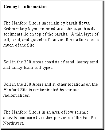
The surface and near-surface soils in the 200 Areas are generally not well developed and consist of a number of soil types such as Rupert sand, Burbank loamy sand, and Ephrata sandy loam. An additional soil unit, Hezel sand, is also present on the western boundary of the 200 West Area (Cushing 1994).
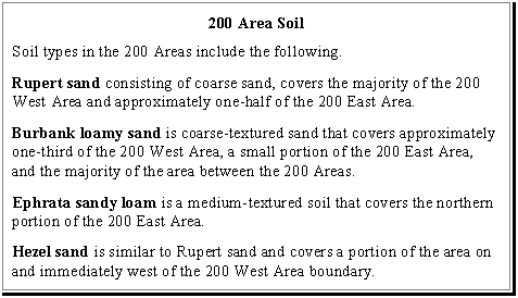
The vicinity of the potential McGee Ranch borrow site contains two soil types: Warden silt-loam and Ritzville silt-loam. Soil at the potential Vernita Quarry borrow site includes the Burbank loamy sand, Ephrata silt-loam, and Kiona silt-loam. The Burbank loamy sand is the predominant soil type in the vicinity of the potential Pit 30 borrow site.
Soil monitoring is conducted at the Hanford Site for radionuclides. Concentrations of cobalt-60, strontium-90, cesium-137, plutonium-239, plutonium-240, and uranium were consistently detected at higher levels in Hanford Site soil than at offsite locations in 1994 and 1995 . In general, radionuclide concentrations near waste disposal sites are higher than concentrations further away. Data for 1995 are quite similar to data for 1994. In general, over the 11-year period from 1983 to 1994, concentrations of cobalt-60, cesium-137, uranium isotopes, and plutonium isotopes in soil did not change. Concentrations of strontium-90 in soil declined because of radiological decay and a downward migration of strontium-90 from the 2.5-centimeters (cm) (1-inch [in.]) soil sampling horizon (PNL 1996).
There are over 2,500 hectares (ha) (6,200 acres [ac]) of surface on the Site that are posted as radiologically controlled areas because contamination exceeds specified levels. Ninety percent of this total is within and near the 200 Areas (PNL 1996) .
4.1.5 Mineral Resources
The only mineral resources produced from the Pasco Basin are crushed rock, sand, and gravel. Deep natural gas production has been tested in the Pasco Basin without commercial success. Local borrow areas would supply rock, silt, sand, and gravel for those alternatives requiring the materials. Although specific borrow sites have not been selected for potential TWRS use, the EIS analyzes the possible use of three potential onsite borrow sites: 1) Pit 30, a potential source of sand and gravel for concrete during construction activities; 2) Vernita Quarry, a potential source of basalt to use as riprap for post-remediation surface barriers; and 3) McGee Ranch, a possible source of silt for post-remediation surface barriers (BHI 1995) .
4.1.6 Seismicity
Earthquakes are the result of stresses that build up in the tectonic plates comprising the earth's surface. These stresses build up due to friction between tectonic plates as they move past each other. Movement can occur within tectonic plates or between plates, such as in subduction zones, where one plate slides underneath another. Seismicity at the Hanford Site is associated with the Cascadia Subduction Zone off the coast of the Pacific Northwest, more than 300 km (180 mi) to the west. The Cascadia Subduction Zone is where the Juan de Fuca tectonic plate slides beneath the North American tectonic plate. Other relevant sources of seismic activity are shallow geologic structures of the Yakima Fold Belt or the Columbia River basalts, and deep structures of the Columbia Basin that underlie the Columbia Plateau.
Seismic activity in the Hanford Site area is low compared to other regions of the Pacific Northwest. In 1936, the largest known earthquake (a Richter magnitude of 5.75) in the Columbia Plateau occurred near Milton-Freewater, Oregon (Cushing 1994). Other earthquakes with a Richter magnitude of 5.0 or larger have occurred near Lake Chelan, Washington to the northwest, along the boundary of the Columbia Plateau and the Cascade Mountain Range, west and north of the Hanford Site, and east of the Hanford Site in Washington State and northern Idaho. In addition, earthquake swarms of small magnitudes that are not associated with mapped faults occur on and around the Hanford Site. An earthquake swarm is a series of earthquakes closely related in terms of time and location.
Four earthquake sources are considered relevant for the purpose of seismic design of TWRS sites: the Rattlesnake-Wallula alignment, Gable Mountain, an earthquake anywhere in the tectonic province, and the swarm area. For the Rattlesnake-Wallula alignment, which passes along the southwest boundary of the Hanford Site, a maximum Richter magnitude of 6.5 has been estimated. For Gable Mountain, an east-west structure that passes through the northern portion of the Hanford Site a maximum Richter magnitude of 5.0 has been estimated. The earthquake for the tectonic province was developed from the Milton-Freewater earthquake, with a Richter magnitude of 5.75. A Richter magnitude 4.0 event is considered the maximum swarm earthquake, based on the maximum swarm earthquake in 1973 (Cushing 1994). The Hanford Site current design basis for new facilities is for facilities to withstand a 0.2 gravity earthquake (Richter magnitude of approximately 6.4) with a reoccurrence frequency of 2.0E-04.
4.2 WATER RESOURCES
Baseline conditions for water and hydrology encompass surface water, the vadose zone (the area between the ground surface and underlying groundwater), and groundwater. The contaminants that presently exist in the Hanford Site water resources are not within the scope of the EIS. The behavior and remediation of existing surface water, the vadose zone, or groundwater contamination will be the subject of other environmental documentation. However, potential cumulative impacts of the TWRS EIS alternatives are discussed in Section 5.13.
4.2.1 Surface Water
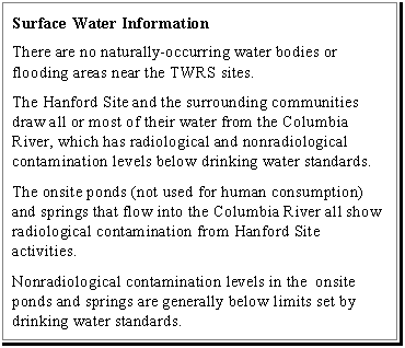
West Lake and two small spring-fed streams in the Fitzner Eberhardt Arid Lands Ecology Reserve are the only naturally-occurring water bodies on the Hanford Site other than the Columbia River. West Lake is several hectares in size and is located approximately 8 km (5 mi) northeast of the 200 West Area and about 3 km (2 mi) north of the 200 East Area. The lake, which is situated in a topographically low-lying area, is sustained by groundwater inflow. West Lake was considered to be an ephemeral water body before Hanford Site operations began, with water level fluctuations dependent on groundwater level fluctuations. Water levels in West Lake became more stable because of recharge primarily from B Pond, which contains secondary wastewater and cooling water from the B Plant. The two small streams in the Fitzner Eberhardt Arid Lands Ecology Reserve are fed by Rattlesnake Springs and Snively Springs (Cushing 1994).
Two ephemeral creeks, Cold Creek and Dry Creek, traverse the uplands of the Hanford Site southwest and south of the 200 Areas. These creeks drain southeasterly toward the Yakima River, located south of the Hanford Site. Surface runoff from the uplands is minor, and creeks flow only during and shortly after rainfall and snow melt. The Columbia River is 11 km (7 mi) or more downgradient from the 200 Areas. The river forms the eastern boundary of the Hanford Site and it comprises the base level and receiving water for groundwater and surface water in the region.
There are no floodplains in the 200 Areas or between the 200 East and 200 West Areas where the potential Pit 30 borrow site is located. Floods in Cold Creek and Dry Creek have occurred historically; however, there have not been any observed flood events or evidence of flooding that has reached the 200 Areas. Natural runoff generated onsite or from offsite upgradient sources is not known to occur in the 200 Areas (Newcomb et al. 1972).
The potential Vernita Quarry borrow site is about 3 km (2 mi) south of the Columbia River. The potential McGee Ranch borrow site is approximately 5 km (3 mi) south of the River. No perennial streams, wetlands, or bodies of surface water have been observed on either site, although the McGee Ranch is dissected by numerous eastward ephemeral drainage systems.
4.2.2 Groundwater
4.2.2.1 Hydrogeologic Setting
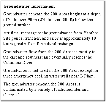
A thick vadose zone (70 to over 90 m [230 to over 300 ft] thick) as well as both confined and unconfined aquifers are present beneath the 200 Areas (DOE 1993a, 1993b). The vadose zone is over 90 m (300 ft) thick in the vicinity of the TWRS sites in the 200 East Areas (DOE 1993a). The confined aquifers are found primarily within the Columbia River Basalts. These aquifers are not a major focus of this EIS because they are separated from the TWRS sites by the vadose zone, unconfined aquifer, and confining layer(s) and thus are not likely to be impacted. The unconfined aquifer has not been formally named. This aquifer consists variably of the Ringold Formation (where the Ringold is present) and the lower portion of the Hanford Formation. The occurrence and flow of groundwater in the unconfined aquifer is inferred from discrete water level measurements in monitoring wells. The following five important concepts describe flow in this aquifer.
- The numerous strata within the Ringold Formation that were described previously in the stratigraphy discussion result in a much lower vertical hydraulic conductivity compared to the horizontal hydraulic conductivity. This results in a strong preference for groundwater to move horizontally rather than vertically.
- Most groundwater movement occurs in the sands and gravel that predominate in the upper portions of the Ringold Formation (Unit E gravels).
- The lower mud sequence and overbank deposits near the base of the Ringold Formation act as confining layers, hydraulically separating the overlying unconfined aquifer from the confined aquifer.
- Recharge to the unconfined aquifer is primarily from artificial sources such as B Pond, groundwater inflow from the Dry Creek and Cold Creek synclines, and recharge from the Columbia River in the general area of N Reactor in the northern portion of the Site.
- Discharge from the unconfined aquifer is primarily to the Columbia River, approximately from the point where the river turns southward in the northern portion of the Site south to the 300 Areas, and in the vicinity of B and C Reactors. Groundwater discharge also occurs to West Lake.
Natural recharge to the unconfined aquifer of the Hanford Site is extremely low and occurs primarily in the upland areas west of the Hanford Site. Artificial recharge from retention ponds and trenches contribute approximately 10 times more recharge than natural recharge. Seasonal water table fluctuations are small because of the low natural recharge.
4.2.2.2 Vadose Zone
At the Hanford Site the vadose zone often includes the Hanford Formation and the Ringold Unit E gravel. The thick vadose zone (70 to over 90 m [230 to over 300 ft]) thick beneath the 200 Areas), combined with the arid climate, result in natural infiltration rates ranging from near 0 to approximately 11 cm/year (4.3 in./year).
The total natural recharge in the 200 West Area is estimated to be approximately 1.3E+08 liters per year (L/year) (3.4E+07 gallons per year [gal/year]) (DOE 1993b). This is based on a recharge rate of 0.1 cm/year (0.04 in./year) through fine-textured soil with deep-rooted vegetation. This value is approximately 10 times lower than recharge volumes from artificial sources.
The current principal sources of artificial recharge in the 200 West Area are four cribs and one ditch associated with the U Plant area, located near the western edge of the 200 West Areas (DOE 1993b). There are also four septic tanks and drain fields that actively discharge water to the vadose zone. The combined volume discharged from these drain fields is estimated to be 12,000 L/day (3,200 gal/day). The total wastewater discharged from these facilities from 1944 to 1992, including the U Plant cribs and ditches, is estimated to have been 1.7E+11 L (4.4E+10 gal). T Plant and S Plant operations also resulted in large volumes of wastewater discharged to the soil. Liquid is no longer discharged from T, U, or S Plants.
DOE injects treated wastewater from the Effluent Treatment Facility, at the State- approved land disposal site located slightly north of the 200 West Area and at the Treated Effluent Disposal Facility, located in the 200 East Area. This water meets all State and Federal discharge requirements except for tritium. The treated water is injected at a location where it is projected that the tritium levels will be within drinking water standards in the groundwater before it reaches the Columbia River.
Natural recharge in the 200 East Area is estimated to be approximately 2E+07 L/year (5E+06 gal/year) (DOE 1993a). This is based on a similar natural recharge rate through fine-textured soil with deep-rooted vegetation, as noted previously for the 200 West Area. Artificial recharge in the 200 East Area is associated with approximately 140 ponds, trenches, cribs, and drains that were used to dispose of approximately 1E+12 L (3E+11 gal) of wastewater. Currently, there are 11 active waste management units and 20 active drain fields. The primary recipients of the wastewater were the ponds and trenches associated with B Plant and the Plutonium-Uranium Extraction (PUREX) Plant; the 216-A-25 trench and 216-B-3 Pond received approximately 8.0E+11 L (2.1E+11 gal). Liquids are no longer discharged from B Plant or the PUREX Plant.
Perched water (small pockets of water trapped in the vadose zone) may occur in the 200 West Area within the vadose zone upon a layer of silt and sand cemented by calcium carbonate (caliche layer). The caliche layer is located approximately 55 m (180 ft) beneath the ground surface (DOE 1993b). Measured hydraulic conductivities of this unit range from 0.0009 to 0.09 m/day (0.003 to 0.3 ft/day). Caliche layers have not been identified in the 200 East Area and generally , perched groundwater is not expected except in localized areas (Hoffman et al. 1992). Perched water has been reported in the vicinity of B Pond within the lower part of the Hanford Formation.
In areas where artificial recharge is occurring from ponds and trenches, soil is expected to be close to saturation and would not likely be capable of holding large amounts of additional liquid. In addition, two groundwater mounds have developed beneath recharge areas, one each in the 200 East and West Areas. Drier soil in portions of the 200 Areas where there is no artificial recharge has a large moisture holding capacity.
4.2.2.3 Aquifer Characterization
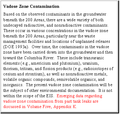
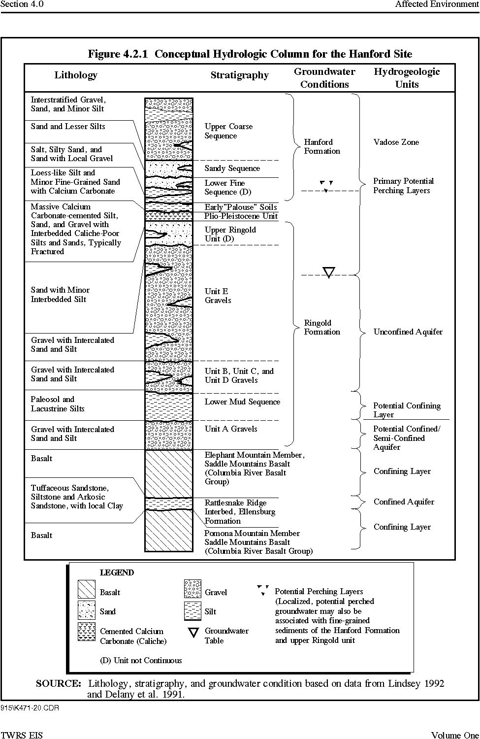
Groundwater of the unconfined aquifer occurs throughout the Hanford Site in the sediment layers above the basalt known as the suprabasalt sediments. The relationship between the various stratigraphic units and the hydrogeologic units is shown in Figure 4.2.1. The depth to groundwater on the Hanford Site is illustrated in Figure 4.2.2.
Groundwater occurs in the 200 West Area within the Ringold Formation primarily under unconfined conditions, approximately 70 m (230 ft) beneath the surface. The saturated section is approximately 110 m (350 ft) thick. Hydraulic conductivities measured in the 200 West Area in the Ringold Unit E aquifer range from approximately 0.02 to 60 m/day (0.06 to 200 ft/day). Hydraulic conductivities range from 0.5 to 1.2 m/day (1.6 to 4 ft/day) in the semiconfined to confined Ringold Unit A gravels (DOE 1993b).
A discontinuous layer of silt and sand cemented by calcium carbonate with thickness of up to 9 m (30 ft) occurs locally at a depth of about 55 m (180 ft) below the 200 West Area. This unit is believed to be responsible for perched water conditions in the vicinity of the TWRS sites in the 200 West Area.
Depth to groundwater in the 200 East Area ranges from 97 m (320 ft) in the southeast to 37 m (120 ft) in the vicinity of the 216-B-3C pond (B Pond mound), which is located approximately 5 km (3 mi) east of the TWRS sites (DOE 1993a). Groundwater near the TWRS sites occurs under unconfined conditions within Ringold Unit A, approximately 96 m (320 ft) deep. The saturated (groundwater) section is approximately 34 m (110 ft) thick. Interconnection between the unconfined and lower confined aquifer is possible across the Central Plateau; however, except for the area near the erosional windows that occur in the basalt several kilometers north of the 200 East Area and B Pond vicinity in the 200 East Area, there is no indication of aquifer interconnection. In the vicinity of B Pond, groundwater mounding from discharges from B Pond have resulted in a downward hydraulic gradient. Several kilometers north of the 200 East Area, there is an absence of confining layer(s) associated with an erosional window which has results in enhanced interconnection of the aquifers in this area. Hydraulic conductivities of the unconfined aquifer near the TWRS sites in the 200 East Area range from 150 to 300 m/day (500 to 1,000 ft/day) (DOE 1993a).
Figure 4.2.1 Conceptual Hydrologic Column for the Hanford Site
Figure 4.2.2 Groundwater Elevation Map of the Hanford Site
4.2.2.4 Groundwater Flow
Groundwater in the 200 West Area generally flows from west to east with some localized exceptions (PNL 1993a). In the northwest corner of the 200 West Area, groundwater flows northward. Also, it appears that flow from the 200 West Area branches out east of Gable Butte, with a flow component northerly toward the gap between Gable Butte and Gable Mountain and the remaining flow branching eastward and southeastward toward the Columbia River.
Groundwater flow in much of the 200 East Area is characterized by relatively low hydraulic gradients, ranging from 0.01 percent to 0.02 percent. Water table elevations in the uppermost aquifer generally decrease from the margins of the Yakima Ridge in the west to the Columbia River in the east. Data indicate that groundwater flow in the vicinity of the TWRS sites in the 200 East Area is toward the southeast (Figure 4.2.2) (PNL 1993a).
The mound resulting from discharge from the 216-B-3 pond (approximately 5 km [3 mi] east of the TWRS site in the 200 Areas) is a notable difference from the generally easterly flow direction. Near the western portion of the mound, the groundwater gradient is reversed to a westerly direction. The magnitude of this gradient direction reversal is currently diminishing as the mound diminishes. The groundwater gradient in the southeastern portion of the 200 East Area is expected to resume a more easterly trend as the mound continues to decline.
Downward hydraulic gradients have been observed in both the 200 East and 200 West Areas. In general, these downward gradients are associated with the groundwater mounds that have been created from infiltration of water discharged to the U Pond and B Pond. Interconnection between the unconfined and lower confined aquifer is possible across the Central Plateau; however, except for the area near the erosional windows that occur in the basalt several kilometers north of the 200 East Area and B Pond vicinity in the 200 East Area, there is no indication of aquifer interconnection. In the vicinity of B Pond, groundwater mounding from discharges from B Pond have resulted in a downward hydraulic gradient. Several kilometers north of the 200 East Area, there is an absence of confining layer(s) associated with an erosional window, which has results in enhanced interconnection of the aquifers in this area.
The groundwater impact analysis provides calculated concentrations of tank waste contaminants for a 10,000-year period of interest. These calculations rely on a conceptual model of the hydrogeologic conditions on the Site and monitoring and characterization data.
The conceptual model for the TWRS EIS is based on characterization data that include geologic structure, the pattern of geologic materials deposited in the vadose zone and underlying aquifer, existing contaminant migration, and the bounding affects of features such as the Columbia River, Yakima River, and Horse Heaven Hills. This results in an expectation that most of the contaminants from the tank sources would move in a west to east/southeast direction with a very small amount flowing northerly through the gap between Gable Butte and Gable Mountain.
The approach used in the TWRS EIS for groundwater impact assessment includes transient contaminant transport through the vadose coupled with steady state contaminant transport through the unconfined aquifer. Data that have been used include measurement of vadose zone and aquifer characteristics and geometry that will remain constant (e.g., hydraulic conductivities, grain size and distribution, and strata thicknesses) and data that are transient (e.g., moisture contents in the vadose zone and groundwater levels in the unconfined aquifer). Of importance here are the transient groundwater data sets that were used for the TWRS EIS and the Hanford Remedial Action EIS (DOE 1996c) analyses. The TWRS groundwater impact analysis focuses on impacts in the groundwater that would occur from about 100 years to 10,000 years from the present based on contaminants reaching the groundwater within about 130 years for the No Action alternative, up to about 3,400 years for the In Situ Vitrification alternative, and a 10,000-year period of interest for all of the alternatives. The TWRS groundwater impact assessment is based on the December 1979 groundwater level data, considering the period in which impacts are expected to occur. The December 1979 groundwater levels used in the TWRS EIS represent a point in time where 1) conditions were relatively steady; and 2) groundwater contaminant transport in the unconfined aquifer is primarily in a southeast/east direction with a small component going in a northerly direction through the gap between Gable Butte and Gable Mountain. For these two reasons, the December 1979 Site groundwater levels were selected as the basis for the TWRS EIS long-term, steady-state groundwater contaminant transport calculation. A slight drawback to use of the December 1979 groundwater level data is that the groundwater mounds associated with B Pond, U Pond, and Gable Mountain Pond are present but they would be expected to be absent in the future (i.e., within 100 years). The presence of the mounds result in a faster vadose zone contaminant transport because the vadose zone was thinner in 1979 than it would be in the future.
The Hanford Remedial Action EIS used 1992 groundwater levels for the impact assessment. These groundwater levels represent a point in time where many transients are ongoing in the groundwater system. Waste water discharges to the vadose zone are decreasing or have been terminated. The groundwater mound associated with Gable Mountain Pond is not present, the mounds associated with B Pond and U Pond have declined, and groundwater is being released from storage in the interstitial pore space of the unconfined aquifer. All of the contaminants originating in the 200 Areas would flow through the gap between Gable Mountain and Gable Butte into the 100 Areas, based on the 1992 groundwater levels used in the Hanford Remedial Action assessment. This is an accurate assumption for the near-term flow directions.
The proportion of contaminants flowing in an easterly direction would be expected to increase from zero percent in 1992 to near 100 percent as the groundwater mound associated with B Pond declines. Therefore by the time contaminants from tank waste remediations reaches the groundwater, the groundwater flow would be to the east as shown in the TWRS EIS. Additional discussion of the sensitivity and potential affect of groundwater mounding is provided in Volume Five, Appendix K.
4.2.3 Water Quality and Supply
4.2.3.1 Surface Water
Water at the Hanford Site is supplied by the Columbia River, which is a source of raw water. River water is supplied to Hanford Site facilities through several distribution systems. In addition, wells supply water to the 400 Area and several remote facilities.
The Tri-Cities draw most (Richland and Kennewick) or all (Pasco) of their water supplies from the Columbia River. In 1994, water usage ranged from 8.7E+09 L (2.3E+09 gal) in Pasco to 2.6E+10 L (6.9E+09 gal) in Richland (Cushing 1995). Each community operates its own water supply and treatment system.
The Columbia River provides water for both irrigation and municipal uses. Washington State has classified the stretch of the Columbia River that includes the Hanford Reach as Class A, Excellent (Neitzel 1996). Class A waters must be suitable for essentially all uses, including raw drinking water, recreation, and wildlife habitat. Both Federal and State drinking water quality standards apply to the Columbia River and are currently being met (Neitzel 1996).
Samples from the Columbia River and three onsite ponds are routinely collected (Figure 4.2.3). Radionuclides consistently detected during 1994 were tritium, strontium-90, uranium-234, uranium-238, iodine-129, plutonium-239, and plutonium-240. The iodine-129, plutonium-239, plutonium-240, strontium-90, and tritium may come from worldwide fallout as well as from releases of Hanford Site effluent. Tritium and uranium also occur naturally in the environment. Total alpha and beta measurements are useful indicators of the general radiological quality of the river; they provide a useful early indication of changes in radiological contamination because results are obtained quickly. Total alpha and beta measurements in 1994 were similar to 1993 and were approximately 5 percent less than the applicable State and Federal drinking water standards at 15 and 50 picocuries per liter (pCi/L), respectively. In general, radiological concentrations at Priest Rapids Dam (upstream of the Site) were generally lower than those at the Richland Pumphouse (downstream of the Site). Concentrations in 1995 were generally similar to those observed in recent years and in most cases were slightly lower than in 1994. Radiological contaminant concentrations measured in 1995 were less than the DOE Derived Concentration Guides and Washington State water quality criteria.
Nonradiological contaminants measured in the Columbia River in 1995 were similar to levels observed in recent years. All nonradiological water quality standards for Class A-designated water were met (PNL 1995). During 1995, there was no indication of any deterioration of water quality resulting from Site operations along the Hanford Reach (PNL 1996).
The three ponds routinely sampled onsite are West Lake (north of the 200 East Area), B Pond (east of the 200 East Area), and the Fast Flux Test Facility Pond (southeast of the 200 Areas). Monitoring data show that all three ponds are impacted by Site activities, although pond water is not used for human consumption. With the exception of uranium-234 and -238 in the October 1995 sample of West Lake, all radionuclide concentrations were less than the DOE Derived Concentration Guides. Average annual total beta concentrations exceeded the ambient surface water quality criteria level in West Lake. The EPA's proposed Hanford Site-specific drinking water standard for uranium also was exceeded in West Lake. The concentrations of all other radionuclides were less than the applicable surface water quality criteria (PNL 1996). West Lake surface water quality reflects the quality of the groundwater that feeds it and thus is potentially impacted by groundwater transport (PNL 1993a).
Figure 4.2.3 Water and Sediment Sampling Locations, 1992
Several springs in the 100 Areas, the old Hanford Townsite Springs and the 200 Area Springs, are routinely sampled. Water flows from these springs are a mechanism by which groundwater contaminated by past Site activities enters the Columbia River. All radiological contaminants measured in 1995 were less than the DOE Derived Concentration Guides. However, strontium-90 in the 100-H Area, and tritium in the 100-B Area and along the Old Hanford Townsite exceeded Federal and Washington State drinking water standards. Total uranium exceeded the EPA's proposed Hanford Site-specific standards in the 300 Area. All other radionuclide concentrations were below applicable surface water quality standards (PNL 1996). The 1995 nonradiological contaminant concentrations were below Washington State ambient surface water acute toxicity standards with the exception of copper and zinc in the 100-K Area spring. The chronic toxicity level of cadmium and the EPA standard for trichlorethylene also were exceeded at the 100-K Area Spring (PNL 1996).
4.2.3.2 Groundwater
Groundwater is not used in the 200 Areas except for emergency cooling water, nor do any water supply wells exist downgradient of the 200 Areas. Three wells for emergency cooling water are located near B Plant in the 200 East Area. However, there are dry and groundwater monitoring wells in and around the 200 Areas. Hanford Site water supply wells are located at the Yakima Barricade, the Fast Flux Test Facility, and at the Hanford Safety Patrol Training Academy, all 13 km (8 mi) or more from the TWRS sites in the 200 East Area.
Groundwater Quality
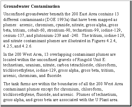
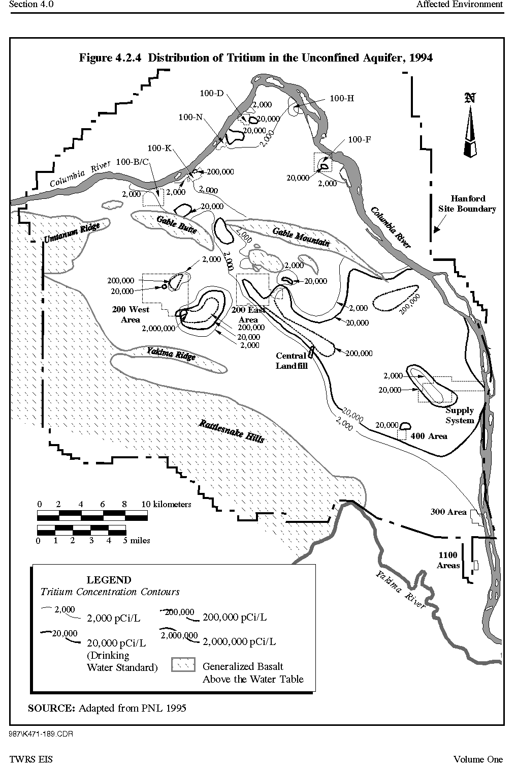
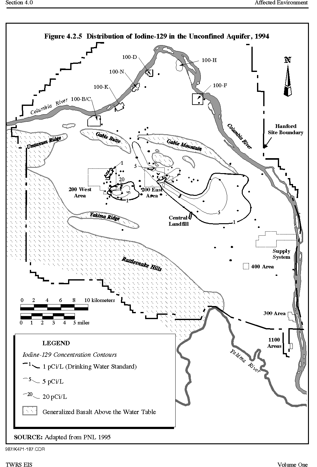
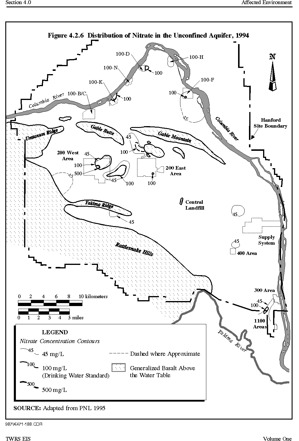
Contamination by both radionuclide and nonradionuclide contaminants has been identified in the groundwater on the Hanford Site. Liquid effluents have been discharged to various ponds, cribs, and other waste management structures located onsite. Adsorption onto soil particles, chemical precipitation, and ion exchange delay the movement of some radionuclides and nonradionuclide contaminants in the effluent as they percolate downward through the vadose zone. Constituents such as strontium-90, cesium-137, and plutonium-239 and -240 are attenuated to varying degrees but eventually may enter the groundwater. Ions such as nitrate and radionuclides such as tritium, technetium-99, and iodine-129, which are not readily attenuated in the soil, reach the groundwater sooner than those that are readily attenuated, and then travel downgradient at essentially the same rate as the natural groundwater. The potential sources of groundwater contamination in the tank farms area are the focus of ongoing investigations (Caggiano 1996 and DOE 1995t). DOE is conducting a RCRA assessment to determine the nature and extent of groundwater contamination beneath certain tank farms (Ecology 1996).
Figure 4.2.4 Distribution of Tritium in the Unconfined Aquifer, 1994
Figure 4.2.5 Distribution of Iodine-129 in the Unconfined Aquifer, 1994
Figure 4.2.6 Distribution of Nitrate in the Unconfined Aquifer, 1994
4.3 METEOROLOGY AND AIR QUALITY
4.3.1 Meteorology
The Hanford Site is located in a semi-arid region. The Cascade Mountains to the west greatly influence the Hanford Site's climate by providing rainshadow. This range also serves as a source of cold air drainage, which has a considerable effect on the Site's wind regime. The following meteorological discussion is based on the Hanford Climatological Summaries (Stone et al. 1972 and PNL 1994g) and information compiled by Cushing (Cushing 1994 and 1995).
Prevailing winds at the Hanford Meteorological Station, located between the 200 Areas, are from the west-northwest and northwest in all months of the year. Monthly average wind speeds are lowest during December, averaging approximately 10 km/hr (6 mi/hr), and highest during June, averaging approximately 15 km/hr (9 mi/hr).
From 1961 through 1990, average monthly temperatures varied from -1 degrees centigrade (C) (30 degrees Fahrenheit [F]) in January to 24 C (76 F) in July with a yearly average of 12 C (53 F). On the average, 51 days during the year have maximum temperatures greater than or equal to 32 C (90 F) and 12 days have a maximum greater than or equal to 38 C (100 F). Also, an average of 25 days during the year have maximum temperatures less than 0 C (32 F) and 106 days per year have minimum temperatures less than 0 C (32 F).
The average annual precipitation measured is 16 cm (6.5 in.) with over half of this occurring from November through February. December, the wettest month, receives an average of 2.5 cm (1 in.), while July, the driest month, averages 0.5 cm (0.2 in.) of precipitation. The annual average snowfall is 38 cm (15 in.).
Although fog has been recorded throughout the year, nearly 90 percent of the occurrences are during the late fall and winter months. Other phenomena that restrict visibility to 10 km (6 mi) or less include dust and smoke (typically from wildfires, orchard smudging, and agricultural field burning). Reduced visibility from blowing dust occurs an average of five days per year, and reduced visibility resulting from smoke occurs an average of two days per year.
Severe high winds are often associated with thunderstorms. On average, the Hanford Site experiences 10 thunderstorms per year, most frequently (80 percent) during May through August.
Good atmospheric dispersion conditions exist at the Hanford Site about 57 percent of the time during the summer (PNL 1994g). Less favorable dispersion conditions occur when the wind speed is light and the mixing layer is shallow. These conditions are most common during the winter when moderately to extremely stable stratification exists about 66 percent of the time. The probability of an inversion period (e.g., poor dispersion conditions) extending more than 12 hours varies from a low of about 10 percent in May and June to a high of about 64 percent in September and October (Holzworth 1972).
4.3.2 Air Quality
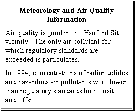
Air quality in the Hanford Site area is good. However, levels of particulate matter occasionally exceed regulatory standards. These elevated levels are believed to result from natural sources such as the dust storms and brush fires that occur in arid eastern Washington State (PNL 1993a and Cushing 1994).
National Ambient Air Quality Standards have been established, as mandated in the Clean Air Act. Ambient air refers to air outside of buildings to which the general public has access. The National Ambient Air Quality Standards define levels of air quality that are considered protective of public health (primary standards) and welfare (secondary standards). The standards exist for the following pollutants: sulfur oxides (measured as sulfur dioxide), nitrogen dioxide, carbon monoxide, particulate matter (a particle that is less than 10 micrometers in diameter), lead, and ozone. The air quality standards specify maximum allowable pollutant concentrations and frequencies of occurrence for averaging periods ranging from one hour to one year, depending on the pollutant. Washington State has largely adopted the current Federal standards. However, Washington State has established more stringent standards for sulfur dioxide and ozone and also maintains an air quality standard for total suspended particulates and gaseous fluorides. Air quality standards are provided in Volume Five, Appendix G.
For selected pollutants for which no Federal or State air quality standards exist, the Hanford Site uses alternate methods of evaluation. For toxic organic compounds (e.g., benzene, toluene), comparisons are made to Occupational Health and Safety Administration's maximum allowable concentrations (29 Code of Federal Regulations [CFR] 1910). Polychlorinated biphenyls are evaluated against National Institute of Occupational Safety and Health occupational limits.
Sources of airborne emissions at the Hanford Site include combustion equipment (e.g., steam boilers, electric generation plants), coal handling operations, storage tanks, and waste handling and disposal. Operations such as these result in routine emissions of air pollutants, including radionuclides.
Under the Clean Air Act Amendments of 1990, the Hanford Site is classified as a major source for one or more criteria pollutants, as well as hazardous air pollutants. The Hanford Site is currently subject to the radionuclide National Emission Standard for Hazardous Air Pollutants (10 millirems per year [mrem/year]). The Clean Air Act requires an operating permit covering all emission sources of pollutants for which the Site is considered a major source. DOE has applied for a Sitewide Air Operating Permit for the Hanford Site.
For areas in attainment of the National Ambient Air Quality Standards, the EPA's Prevention of Significant Deterioration program is designed to protect existing ambient air quality in an area while also allowing a margin for future growth. Under the Prevention of Significant Deterioration program, new stationary sources of air pollution may only impact air quality by set increments, and best available control technology emission controls must be installed. The Hanford Site obtained a Prevention of Significant Deterioration permit in 1980 requiring specific limits for oxides of nitrogen emitted from the PUREX Plant and U Plant. These facilities were not operated in 1995 and no Prevention of Significant Deterioration permit violations occurred (Neitzel 1996).
Onsite air quality monitoring data are available for nitrogen oxides, polychlorinated biphenyls, and volatile organic compounds (PNL 1995). Monitoring of nitrogen oxides was discontinued after 1990 because the primary source (the PUREX Plant) ceased operation. The highest annual average nitrogen oxides concentration was approximately an order of magnitude below the Federal and Washington State standard of 0.05 parts per million. Nine out of 17 polychlorinated biphenyls samples collected during 1993 were below the detection limit of 0.29 nanograms per cubic meter, and thus well below the level of concern. Eight samples were above the detection limit, with results from 0.25 to 3.9 nanograms per cubic meter (Cushing 1995).
Based on a review of chemicals of concern for surveillance at the Site, three types of semi-volatile organic compounds were identified for monitoring, polychlorinated biphenyls, polycyclic aromatic hydrocarbons, and a phthalate ester plasticizer. Organochlorine pesticides also were analyzed. No phthalate esters were found above detection limits. Polycyclic aromatic hydrocarbons, polychlorinated biphenyls, and organochlorine pesticides were found above detection limits. The measured pesticide concentrations were orders of magnitude below occupational exposure limits (PNL 1996).
Ten volatile organic compound samples were collected and analyzed in 1994. The samples were analyzed for halogenated alkanes and alkenes, benzene, and ethylbenzenes. Overall, the concentrations measured in 1994 were within the range of values reported in previous studies and also were within allowable regulatory limits (PNL 1995).
During 1993, the only offsite monitoring near the Hanford Site showed the 24-hour particulate matter standard of 50 micrograms per cubic meter (µg/m3) being exceeded twice at the Columbia Center monitoring location in Kennewick. The maximum 24-hour concentration of 150 µg/m3 was exceeded twice, with the highest level reaching 1,166 µg/m3. The suspected cause was windblown dust. The annual primary standard of 50 µg/m3 was not exceeded.
Radiological data were collected during 1995 through a network of 47 continuously operating samplers at onsite radiological monitoring stations, at the Site perimeter, and at nearby and distant communities. Cesium-137, plutonium-239, plutonium-240, strontium-90, and uranium were consistently detected in air samples collected in the 200 Areas. Concentrations were higher than those measured at offsite locations and were in the same range as measured in previous years . Levels measured at both onsite and offsite locations were much lower than the applicable standards (PNL 1996 ).
4.4 BIOLOGICAL AND ECOLOGICAL RESOURCES
The Hanford Site and adjacent region are a shrub-steppe vegetation zone that is dominated by a shrub overstory (top layer) with an understory (bottom layer) of grasses (Daubenmire 1970). Ecological resources on the Site are extensive, diverse, and important. Because the Hanford Site has not been farmed or grazed for over 50 years, it has become a refuge for a variety of plant and animal species (Gray-Rickard 1989). The Site contains one of the largest remaining undisturbed shrub-steppe areas in Washington State. Approximately 665 km2 (257 mi2) of undeveloped lands located onsite (nearly half the Site's total area) have been designated as ecological study areas or refuges.
4.4.1 Biodiversity
Biodiversity is the diversity of ecosystems, species and genes, and the variety and variability of life (CEQ 1993). Major components of biodiversity are plant and animal species, microorganisms, ecosystems, ecological processes, and the interrelationships between and among these components. Biodiversity is a qualitative measure of the richness and abundance of ecosystems and species in a given area (NPS 1994). Biodiversity also provides a moderating effect on wide fluctuations in environmental conditions .
Two major factors contributing to biodiversity on the Hanford Site are that 1) the Site is one of the largest relatively undisturbed tracts of native shrub-steppe left in the State of Washington; and 2) the Hanford Reach is the last free-flowing nontidal stretch of the Columbia River in the United States (Sackschewsky et al. 1992 and Cushing 1992). Other factors contributing to the Site's biodiversity include topographic features such as Rattlesnake Mountain, Gable Butte, and Gable Mountain; a variety of soil textures ranging from sand to silty and sandy loam; and the lack of human use and development over much of the Hanford Site. Specialized terrestrial habitats contributing to the biodiversity of the Hanford Site include areas of sagebrush-steppe, basalt outcrops, cliffs, and sand dunes. Aquatic components of biodiversity are mainly associated with the Columbia River and include aquatic habitats, wetland and riparian areas, and riverine habitats along the Hanford Reach shoreline and islands in the Columbia River.
Ecologically important plant and animal species on the Hanford Site include Federal and Washington State protected wildlife and plant species (Section 4.4.5); commercial and recreational wildlife species such as salmon, steelhead, mule deer, and upland game birds; and plant species used as a source of food, medicine, fiber, and dye by native people of the Columbia Basin (Section 4.4.6) (Sackschewsky et al. 1992).
As an indication of the Site's biodiversity, the Nature Conservancy of Washington has recently discovered 21 new plant and insect species on the Site. This includes new species of buckwheat and bladderwart plants and 19 species of insects (Nature Conservancy 1996) .
4.4.2 Vegetation
The Hanford Site is a relatively undisturbed area of shrub-steppe (Sackschewsky et al. 1992). Approximately 600 different plant species exist on the Site (Cushing 1994). Historically, the predominant plant in the area was big sagebrush with an understory of perennial bunch grasses. Following Euro-American settlement that began in the early 1800's, grazing and agriculture disrupted the native vegetation and opened the way for invader species such as tumbleweed, Russian-thistle, and cheatgrass.
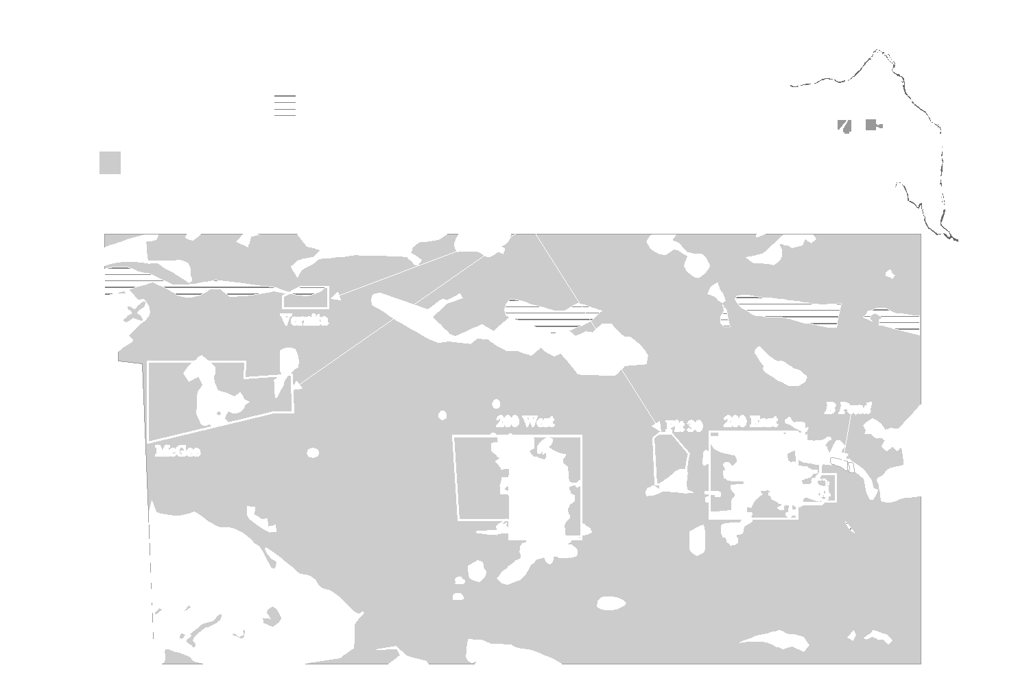
The Central Plateau and the nearby area that contains the potential Vernita Quarry and McGee Ranch borrow sites predominantly consist of shrub-steppe. Figure 4.4.1 is a simplified vegetation map of the areas of the Hanford Site where TWRS activities are proposed. This includes plant communities dominated by big sagebrush and bitterbrush with an understory of cheatgrass or Sandbergs bluegrass. Shrub-steppe is considered a priority habitat by Washington State because of its importance to wildlife species of concern. Also, the National Biological Service has listed native shrub- and grassland-steppe in Washington State and Oregon as an endangered ecosystem. Over 100 plant species occur on the Central Plateau. Common species include big sagebrush, rabbitbrush, cheatgrass, and Sandbergs bluegrass. Much of the land surface of the 200 Areas has been disturbed by human activities. Introduced species such as Russian-thistle and cheatgrass are common in these disturbed areas (Cushing 1994). Approximately 58 percent of the 200 Area's 2,600 ha (6,400 ac) is disturbed by facilities, about 40 percent is shrub-steppe or recovering shrub-steppe, and 2 percent is cheatgrass (ASI 1995).
Figure 4.4.1 TWRS Areas Vegetation Types (Simplified)
Other vegetation in the 200 Areas includes wetland species associated with human-made ditches and ponds and introduced perennial grass planted to revegetate disturbed areas. Wetland species (e.g., cattail, reeds, and trees such as willow, cottonwood, and Russian-olive) are established around some of these ponds, none of which are in the immediate vicinity of any of the TWRS sites. Introduced perennial grass, such as Siberian crested wheatgrass, also has been used in the 200 Areas to revegetate and stabilize waste burial grounds against wind and water erosion.
Biological surveys of the TWRS sites in the 200 East Area and the immediately surrounding vicinity show that approximately 40 percent of the area is big sagebrush and grey rabbitbrush, both native species characteristic of shrub-steppe communities. Another 20 percent is Russian-thistle, with the remainder being either disturbed vegetation or bare gravel (PNL 1994e). The area of the proposed Phased Implementation alternative site in the easternmost portion of the 200 East Area contains both mature sagebrush habitat and areas disturbed by the development of grout vaults in the 1980's. None of the new plant species recorded by the Nature Conservancy were identified at any of the potential TWRS locations in the 200 Areas (Brandt 1996).
The tank farms and immediate surrounding areas in both the 200 East and West Areas are heavily disturbed. The potential Vernita Quarry, McGee Ranch, and Pit 30 borrow sites are all largely undisturbed shrub-steppe areas, with species such as big sagebrush, rigid sage, and spiny hopsage, and an understory of grasses such as Sandbergs bluegrass. Portions of the potential McGee Ranch borrow site were farmed in the early part of the twentieth century, and these farmed areas are dominated by cheatgrass and Russian-thistle. The McGee Ranch area is also an important wildlife and vegetation corridor connecting the Site with the Yakima Training Center further to the west. The Yakima Training Center and the Hanford Site are the two largest tracts of shrub-steppe remaining in Washington State (Fitzner 1992). The Washington State Department of Fish and Wildlife has asked DOE to preserve the McGee Ranch area as a wildlife corridor (Baker 1996).
4.4.3 Wildlife
Approximately 290 species of terrestrial vertebrates have been observed at the Hanford Site, including 41 species of mammals, 238 species of birds, 3 species of amphibians, and 9 species of reptiles (Weiss-Mitchell 1992). Major terrestrial habitat types on the Hanford Site include basalt outcrops, scarps (cliffs) and screes, riparian areas, shrub-steppe, sand dunes, and abandoned fields (Downs et al. 1993).
Predominant mammal species include the mule deer and Rocky Mountain elk; predators such as coyotes, bobcats, and badger; and a variety of small mammals (marmots, squirrels, rabbits) (Cushing 1992). The elk population, which has grown during the Hanford Site's existence, occurs primarily on the Fitzner Eberhardt Arid Lands Ecology Reserve , although elk reportedly also have been sighted on the islands in the Columbia River and along the Columbia River (CTUIR 1996) . Mule deer may occur almost anywhere on the Hanford Site, although they are found more commonly along the Columbia River. White-tailed deer have been sighted occasionally along the Columbia River and at the Yakima River Delta in Richland.
The approximately 240 bird species on the Hanford Site include a variety of raptors (birds of prey), songbirds, and species associated with riparian and upland habitats (Landeen et al. 1992). No riparian or upland habitats exist within 3 km (2 mi) of any of the TWRS sites under any alternative. Twenty-six species of raptors have been sighted, 11 of which are known to nest on the Site. These include five species of owls, the northern harrier, three hawk species, the prairie falcon, and the American kestrel. Songbird species known to occur in the Hanford Site's shrub-steppe vegetation include the loggerhead shrike, sage sparrow, western meadowlark, grasshopper sparrow, common raven, horned lark, and sage thrush. The western meadowlark, sage sparrow, and horned lark are the most abundant shrub-steppe songbird species that breed on the Site. Common upland game bird species include the chukar partridge, California quail, and Chinese ring-necked pheasant. Sage grouse and gray partridge are less common, with the once common sage grouse now essentially displaced from the Site since a major wildfire occurred in 1984. None of the upland birds are native to the area except the sage grouse.
Nine species of reptiles and three species of amphibians occur on the Hanford Site. The most abundant reptile is the side-blotched lizard. The short-horned lizard and northern sagebrush lizard also are common in habitats such as mature sagebrush. Common snakes include the gopher snake, yellow-bellied racer, and Pacific rattlesnake. Less common are the striped whipsnake and desert night snake. Amphibians on the Hanford Site, which are associated with riparian habitats located along permanent water bodies of the Columbia River, include the Great Basin spadefoot, Woodhouses toad, and the Pacific treefrog. More than 300 species of terrestrial and aquatic insects occur on the Hanford Site (Cushing 1992). Grasshoppers and darkling beetles represent some of the more conspicuous groups.
Aquatic habitats on the Hanford Site, none of which are near any TWRS sites, are associated primarily with the Columbia River, two small spring-fed streams on the Fitzner Eberhardt Arid Lands Ecology Reserve, West Lake, and artificial ponds and ditches occurring in or near the 200 Areas (Cushing-Watson 1974, Emery-McShane 1978, and Cushing 1994). The Columbia River supports a large and diverse community of plankton, benthic invertebrates, and fish. The springs are also diverse and productive (e.g., dense watercress blooms and a fairly high insect production). The artificial ponds and ditches, many of which are abandoned and dried out, often provide lush riparian habitat and support populations of migrating and breeding birds, particularly waterfowl.
4.4.4 Sensitive Habitats
Sensitive habitats on the Hanford Site include wetlands and riparian habitats. However, there are no sensitive habitats at or near any TWRS sites (Cowardin et al. 1979). The Hanford Site's primary wetlands occur along the Columbia River. Other Hanford Site wetland habitats are associated with human-made ponds and ditches (e.g., B Pond and its associated ditches located near the 200 East Area). Wetland plants occurring along the shoreline of B Pond include herbaceous and woody species such as showy milkweed, western goldenrod, three square bulrush, horsetail rush, common cattail, and mulberry, among others (Sackschewsky et al. 1992). Wildlife species observed at B Pond include a variety of mammals and waterfowl species (Meinhardt-Frostenson 1979).
4.4.5 Species of Concern
Species of concern on the Hanford Site include Federally-listed threatened and endangered species, Federal candidate species (50 CFR 17), Washington State threatened or endangered species, Washington State candidate species, monitor species, and sensitive plant species.
No Federally-listed threatened or endangered plant or animal species occur on or around the Central Plateau (Sackschewsky et al. 1992). Pipers daisy, a Washington State sensitive species, has been found at B Pond near the 200 East Area and at the potential Pit 30 borrow site between the 200 East and 200 West Areas. The crouching milkvetch, stalked-pod milkvetch, and squill onion, all Washington State Class 3 monitor species, also are found in the vicinity (Duranceau 1995). Class 3 monitor species are either more abundant or less threatened than previously assumed, or both.
Wildlife species of concern on the Central Plateau and vicinity include the loggerhead shrike, which is a Federal and Washington State candidate species, and the sage sparrow, which is a Washington State candidate species. Both species nest in undisturbed sagebrush habitat in the Central Plateau and nearby areas. Other bird species of concern that may occur in shrub-steppe habitat of the Hanford Site are the burrowing owl, a Washington State candidate species; the ferruginous hawk, a Washington State threatened and Federal Category 2 candidate species; the golden eagle, a Washington State candidate species; the long-billed curlew, a Washington State monitor species; the sage thrasher, a Washington State candidate species; the prairie falcon, a Washington State monitor species; and Swainsons hawk, a Washington State candidate species (Downs et al. 1993, Sacksewsky et al. 1992, and Landeen et al. 1992).
The western sage grouse, a Federal and State-listed threatened species, was present in areas near the Central Plateau until the local population was displaced by a major wildfire in 1984. The sage grouse has not been observed on the Site since that time. The bald eagle, also a Federal and State-listed species, has been a regular winter resident in recent years of the Hanford Reach of the Columbia River. The bald eagle forages on salmon carcasses and waterfowl along the river and is not known to use the Central Plateau of the Site, which is 10 km (6 mi) or more from the river.
Nonavian wildlife species of concern include the striped whipsnake, a Washington State candidate species; the desert night snake, a Washington State monitor species; the pygmy rabbit, a Federal Category 2 candidate species; and the northern sagebrush lizard, also a Federal Category 2 candidate species.
Prehistorically and historically, the Native Americans of the Hanford Site vicinity fished for salmon in the Columbia River, gathered roots in the areas now called Moses Lake and Ephrata, and hunted and gathered berries in the mountains. They wintered in the lowlands by the Columbia River. However, the Native Americans hunted, fished, and gathered foods whenever the opportunities presented themselves.
Big game , including elk and antelope, were abundant on the Columbia Plateau , according to affected Tribal Nations (CTUIR 1996) . Smaller mammals (marmots, squirrels, rabbits) were important food sources in the area. Bird species were a food source , and birds and bird parts also were used for medicinal and religious purposes (Hunn 1990). Fish were and remain an important part of the Native American diet in the Columbia River area. Although the 200 Areas themselves have no fishery resources, the fishery resource of the Hanford Reach of the Columbia River is important to Native Americans.
Plants have been and remain important to Native Americans for food, medicine, cordage, building materials, and as materials of religious and spiritual significance. For example, a substantial portion of the aboriginal diet was composed of food plants, with tubers being the most important food plant type (Hunn 1990). Several dozen plant species with specific uses (e.g., medicine, food) in traditional Native American culture and lifestyles have been identified on the Hanford Site by non-Native American researchers. A number of these species were identified in the 200 East Area during 1994 biological surveys (Fortner 1994). In the Native American view, however, identifying specific plant species as being of particular value is inappropriate because "any such attempts at separating interdependent components of a holistic system are contrary to tribal and cultural resources values" (CTUIR 1994).
4.5 CULTURAL RESOURCES
Three categories of cultural sites at the Hanford Site include 1) prehistoric sites, which represent Native American cultures and societies; 2) historic era sites, which generally must be at least 50 years old, although items and structures built in support of the Hanford Site's defense mission during World War II and the Cold War Era must also be considered (PNL 1989); and 3) ethnographic sites (traditional cultural sites) that are important to the heritage of contemporary Native American communities. The Hanford Site contains a rich diversity of known cultural sites in all three categories.
The Hanford Site contains seven districts listed in the National Register of Historic Places, as well as numerous other well-preserved archaeological sites. The overall condition and thus potential importance of the Hanford Site's cultural sites is high because the area has had limited public access for over 50 years. Limited access has preserved most archaeological sites from looting and other adverse impacts. Areas similar to the Hanford Site along the Columbia River have been inundated by water from hydroelectric development. Because the Hanford Site has not experienced this type of development and the resulting depletion of cultural sites, it represents a uniquely preserved area.
In addition to its archaeological and historic sites, the Hanford Site land is of importance to Native American peoples because all natural resources are also cultural resources to indigenous peoples (CTUIR 1996) . The Hanford Site also is part of the original homeland of several Hanford Site Nations (CTUIR 1996) .
Archaeological sites in the 200 Areas are scarce (Chatters-Cadoret 1990). Cultural resource surveys have been conducted within the 200 East Area covering all undeveloped areas (Chatters-Cadoret 1990). The number of prehistoric and historic archaeological sites recorded as the result of these surveys is very limited. Findings recorded in the areas around and including the TWRS sites consist of isolated artifacts and four archaeological sites (ASI 1994). Cultural resources surveys of the TWRS sites and immediate vicinity in the 200 East Area, which were conducted in 1994, found no sites eligible for the National Register of Historic Places (PNL 1994a, b, c). Past surveys of the Phased Implementation alternative site in the easternmost portion of the 200 East Area revealed no archaeological sites (Cadoret 1995). However, both the 200 East and 200 West Areas contain potentially historic buildings and structures associated with the Hanford Site's defense mission (Crist 1994).
Surveys of the 200 West Areas recorded a few historic sites, isolated archaeological artifacts, and a segment of the historic White Bluffs Road that runs across the Site between Rattlesnake Springs and the Columbia River (Chatters-Cadoret 1990). The White Bluffs Road, which has been nominated for the National Register of Historic Places, traverses the northwest corner of the 200 West Area. This road was used in prehistoric and historic times by Native Americans and was an important transportation route for Euro-Americans in the 19th and early 20th century for mining, agriculture, and other development uses. The segment in the 200 West Area is not considered an important element in its historic value because it has been fragmented by past activities (Cadoret 1995). However, the Confederated Tribes of the Umatilla Indian Reservation have indicated that the White Bluffs Road is important culturally to Native Americans even though it has been affected by past activities (CTUIR 1996).
The potential Vernita Quarry and McGee Ranch borrow sites have potential for both historic and prehistoric materials. Surveys have identified prehistoric isolated artifacts and prehistoric or historic sites at both Vernita and McGee Ranch (Duranceau 1995). The McGee Ranch area has been determined to be eligible for nomination to the National Register of Historic Places as the McGee Ranch/Cold Creek District (Cadoret 1995). No prehistoric sites are known at the potential Pit 30 borrow site, which is located between the 200 East and 200 West Areas, although one structure from the homestead era is located at Pit 30.
4.5.1 Prehistoric Resources
As indicated previously, survey data for the 200 East Area revealed no substantial prehistoric resources (Chatters-Cadoret 1990). Much of the land surface in the 200 Areas has been extensively disturbed by previous construction and other development activity, although disturbed areas still have the potential to contain cultural resources . The 1994 survey of the TWRS sites and surrounding vicinity in the 200 East Area revealed only isolated artifacts and sites (scattered stone tool fragments) (PNL 1994a, b, c). There also are very few known prehistoric sites in the relevant portions of the 200 West Area. Prehistoric materials have been found at the potential Vernita Quarry and McGee Ranch borrow sites.
4.5.2 Historical Resources
The first Euro-Americans to enter this region were Lewis and Clark in the beginning of the nineteenth century. By the early twentieth century, cattle ranching, farming and several small, thriving towns were present, including Hanford, White Bluffs, and Ringold. The towns, settlements, and nearly all other structures were razed after the Federal government acquired the land for the Hanford Site in the early 1940's (PNL 1989 and Cushing 1994). Today, the remnants of homesteads, farm fields, ranches, and abandoned military installations can be found throughout the Hanford Site. There are nearly 5,200 ha (13,000 ac) of abandoned agricultural lands on the Site.
More recent are the nuclear reactors and associated processing facilities developed during the Manhattan Project and the Cold War era that are found on the Site. The various reactor sites around the Hanford Site cover over 900 ha (2,300 ac) of land area. All of the reactor buildings and major processing facilities still stand, although many ancillary support structures have been removed. The 100-B Reactor has been listed individually on the National Register of Historic Places and is a National Mechanical Engineering Monument and approximately 110 other buildings have been evaluated. The Washington State Historic Preservation officer and DOE have determined that the Hanford Site is a Manhattan Project/Cold War era historic district (Neitzel 1996). There are plans to complete the process of inventorying and evaluating the remaining buildings and structures associated with the Manhattan Project and Cold War Era in the 200 Areas by the end of 2000 (DOE 1996e) . Currently, historic structure evaluations at the Hanford Site are conducted on an as-needed basis before altering or demolishing a structure.
Historic buildings associated with the development of nuclear technology exist in both of the 200 Areas, particularly plutonium production and processing facilities. Few of these have been evaluated for National Register of Historic Places eligibility, although none are expected to be impacted by TWRS activities under any alternative (PNL 1989 and Cushing 1995). The underground storage tanks that currently contain the tank waste may be considered historically important. A Programmatic Agreement concerning cultural resources management of the built environment at the Hanford Site has been signed by the U.S. Department of Energy (DOE) , the Advisory Council on Historic Preservation, and the Washington State Historic Preservation Office (DOE 1996e). Under the agreement, DOE will document one SST and one DST on historic property inventory form.
4.5.3 Native American Sites
The Hanford Site vicinity contains lands ceded to the United States by both the Confederated Tribes and Bands of the Yakama Indian Nation and the Confederated Tribes of the Umatilla Indian Reservation in the treaties of 1855. Until 1942, the Wanapum resided on land that is now part of the Hanford Site. In 1942, the Wanapum People moved to Priest Rapids when the Hanford Site was established. The Nez Perce Tribe also retained rights to the Columbia River under a separate treaty with the U.S. Government.
The area of the Hanford Site near the Columbia River has been occupied by humans for over 10,000 years, as reflected by the extensive archaeological deposits along the river shores. Inland areas with water resources also point to evidence of concentrated human activity. Recent surveys indicate extensive although dispersed use of semi-arid lowlands for hunting. However, surveys have recorded very few Native American sites or artifacts in and around the 200 Areas (Chatters-Cadoret 1990). Native American sites and artifacts have been identified at both McGee Ranch and the Vernita Quarry (potential borrow sites) .

Native Americans have retained traditional secular and religious ties to the Hanford Site. No specific sites of religious significance have been identified at the TWRS sites. However, affected Tribal Nations indicate that there are culturally important biota, sacred sites such as Gable Mountain, and other culturally important properties within areas that might be impacted by TWRS alternatives (i.e., groundwater downgradient from TWRS sites, the Columbia River, and locations downwind of possible TWRS air releases) (CTUIR 1996).
4.6 SOCIOECONOMICS
The socioeconomic analysis focuses on Benton and Franklin counties. The counties make up the Richland-Kennewick-Pasco Metropolitan Statistical Area, also known as the Tri-Cities, a term that is frequently used to designate the Metropolitan Statistical Area. Other jurisdictions in Benton County include Benton City, Prosser, and West Richland. Connell is the largest city in Franklin County after Pasco. Neighboring counties (Yakima, Walla Walla, Adams, and Grant counties in Washington and Umatilla and Morrow counties in Oregon) are impacted by activities at the Hanford Site; however, in terms of socioeconomics, the Site's impacts on these counties is very small (Serot 1995).
On February 11, 1994, Executive Order 12898, Federal Actions to Address Environmental Justice in Minority Populations and Low-Income Populations, was published in the Federal Register. The Order requires Federal agencies to identify and address disproportionately high and adverse human health or environmental effects of its programs, policies, and activities on minority populations and low-income populations. Currently, no formal guidelines have been adopted to implement the Executive Order; however, EPA has published relevant studies and information on environmental justice. DOE is a participating member of this task force.
In accordance with Executive Order 12898, information is provided in Section 4.6.1 concerning the minority populations and low-income populations within an 80-km (50-mi) radius of the Hanford Site. This discussion provides the basis for analyzing potential disproportionate and adverse environmental impacts of TWRS EIS alternatives on minority populations and low-income populations. The 80-km (50-mi) radius includes counties not otherwise addressed in this section because overall Hanford Site socioeconomic impacts on these counties are very minor. However, the section does describe minority population and employment within the Hanford Site's primary zone of socioeconomic influence, the Tri-Cities area (Benton and Franklin counties).
Before World War II, the economy in the Tri-Cities area was based primarily on agriculture. Since World War II, the Hanford Site has been the largest factor in the local economy. Plutonium production and processing was the primary mission of the Site until 1988, when the mission changed to environmental restoration and waste management. Basic and applied research are an important secondary mission.
Historically, changes in the Hanford Site's mission and the cancellation in the early 1980's of a Washington Public Power Supply System project at the Hanford Site have had measurable impacts on the economy of the Tri-Cities area. Boom-bust cycles have occurred that have had ramifications for employment, population, housing, and infrastructure. Table 4.6.1 shows Hanford Site employment, Washington Public Power Supply System employment, and total nonfarm employment for the Tri-Cities area, together with the area's population for 1980 to 1994. These data do not reflect the ongoing reductions in Site employment in 1995 (i.e., an expected reduction from 1994 levels of approximately 4,500 jobs by the end of 1995). The Washington Public Power Supply System workforce was reduced to approximately 1,500 by mid-1995.
4.6.1 Demographics
4.6.1.1 Population Trends
Population tended to follow changes in nonfarm employment in the Tri-Cities area during the 1980's and early 1990's (Table 4.6.1). The population trends apparently reflected not only existing employment at the Hanford Site and elsewhere in the area, but also expectations about future employment opportunities.
Table 4.6.1 Population and Employment in the Tri-Cities Area, 1980 to 1994
Table 4.6.2 shows the 1990 population for Benton and Franklin counties and, for comparison, Washington State by race and minority status. The data show that minorities are a smaller percentage of Benton County population (8.7 percent) than in Franklin County (28.2 percent) or in Washington State (11.5 percent). The largest minority group in the area is the Hispanic Origin group, which makes up 30.2 percent of the population of Franklin County and 7.7 percent of Benton County. African Americans make up 1 percent of Benton County's population and 3.5 percent of Franklin County's population. Native Americans account for less than 1 percent of the population in each county, while Asians and Pacific Islanders account for approximately 2 percent of each county's population.
Benton County's farm population is more than twice as large (as a percentage of total population), than for Washington State as a whole (12.6 percent to 5.5 percent). Franklin County's farm population is almost five times as large on a percentage basis (24.9 percent) as Washington State's farm population. Franklin County's nonfarm rural population makes up 30 percent of the county's total population, which is virtually the same as the State's (29.3 percent), while more than twice the percentage in Benton County (13.0 percent). These data suggest the relative importance of farming in Franklin County and to a lesser extent in Benton County as compared to Washington State as a whole.
Table 4.6.2 Population by Race and Minority Status, 1990
4.6.1.2 Minority and Native American Populations and Low-Income Populations Within an 80-km (50-mi) Radius of the Hanford Site
Federal environmental justice policy requires identifying all minority and Native American and low-income populations that potentially could be subject to disproportionately high and adverse impacts resulting from the proposed action (EO 12898). Identifying potentially impacted minority and Native American populations and low-income populations in the 80-km (50-mi) area surrounding the Hanford Site's Central Plateau (where TWRS activities would be focused) involved analyzing the 1990 census data (DOC 1991). In 1990 the 80-km (50-mi) radius surrounding the Hanford Site contained a total population of approximately 448,000 and includes all of Benton County and portions of another nine surrounding counties (seven in Washington State and two in Oregon). Much of the Yakama Indian Reservation is located within the 80-km (50-mi) radius. The Wanapum People maintain a small residential community north of the Site near Priest Rapids Dam. In addition, the Confederated Tribes of the Umatilla Indian Reservation (located in northeastern Oregon) and the Nez Perce Tribe (located in northern Idaho) have historical and treaty interests in the Hanford Site area.
The process of identifying minority and Native American and low-income communities for the EIS environmental justice analysis is described in Volume Five, Appendix I (Section I.6.1).
Minority and Native American Populations
As of the 1990 census, the 80-km (50-mi) area surrounding the Hanford Site's Central Plateau had a total minority and Native American population of 86,400. The area's minority and Native American population of 19.3 percent exceeded the Washington State average of 13.1 percent. The Hispanic population (14.3 percent or 64,300 individuals) is the area's principal minority group. The Hispanic population is relatively evenly dispersed throughout the area. African American (1.2 percent or 5,200 individuals) and Asian (1.4 percent or 6,100 individuals) populations are very small and are located predominantly in Yakima, Benton, and Franklin counties. The Native American population consists of 2.4 percent or 10,800 of the area's population. The Native American population is predominantly located on the Yakama Indian Reservation. Other Native American populations include members of the Confederated Tribes of the Umatilla Indian Reservation, the Wanapum People, and the Nez Perce Tribe.
Of the 97 census tracts that are contained completely or partially within the 80-km (50-mi) radius of the Site in 1990, 17 had minority and Native American populations greater than 33 percent of the census tracts, total population (Figure 4.6.1). These 17 census tracts contained less than one-fifth of the area's total population, but more than half of its total minority and Native American population. Moreover, these 17 census tracts were home to over 63 percent of the area's Native American residents and at least 56 percent of the area's Hispanic population. The 17 tracts had an average minority and Native American population of nearly 52 percent per tract. The fact that these 17 tracts contained more than half of the 80-km (50-mi) area of interest's total minority and Native American population is the reason that they are the focus of the EIS environmental justice analysis.
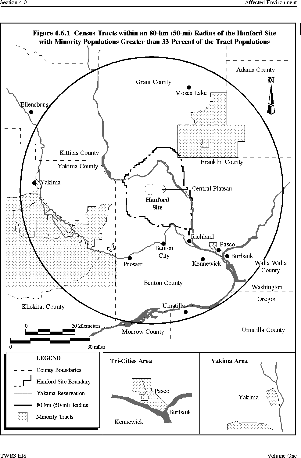
Geographically, the tracts with the highest fraction of minority and Native American populations are located in Adams, Grant, Franklin, and Yakima counties, and the Yakama Indian Reservation. Of the remaining 80 census tracts in the area of interest, 49 had 1990 minority and Native American populations of less than 10 percent, 23 had minority and Native American populations under 20 percent, and eight had minority and Native American populations between 21 percent and 33 percent. Five census tracts, all located within the Yakama Indian Reservation, contained substantial Native American populations. In 1990, these tracts had nearly 57 percent of the 80-km (50-mi) radius area's Native American population and were the only census tracts in the area where the percentage of Native American population exceeded 8 percent of the census tract's total population.
All of the 17 census tracts with a minority and Native American population greater than 33 percent in 1990 had large numbers of individuals listed in the census "Other" category (census categories include White, Black, American Indian, Asian, and Other; the Other category generally is thought to include many Hispanics). In all but 3 of the 17 tracts, the Other category alone accounted for more than 33 percent of the tract's total population. Two of these three tracts are located on the Yakama Indian Reservation and have substantial Native American populations; the third tract is located in Franklin County.
Low-Income Populations
In all, 25 of the 97 census tracts within the 80-km (50-mi) radius of the Hanford Site had 1990 low-income populations greater than 22 percent of their total population (Figure 4.6.2). These 25 census tracts contained approximately 28 percent of the area's total residents and 51 percent of the region's total low-income population. The fact that the 25 tracts contained more than half of the region's total low-income population is the reason that they are the focus of the environmental justice analysis of low-income populations. The 25 tracts had a total average low-income population of more than 31 percent. The tracts with high low-income populations (22 percent or greater) are located in Adams, Grant, Franklin, and Yakima counties (including the Yakama Indian Reservation). Of the remaining 72 census tracts, 30 tracts had low-income populations in 1990 less than the Washington State average of 10.9 percent; 27 tracts had low-income populations between 11 percent and 17.3 percent (the average low-income population level for the 80-km [50-mi] radius); and 15 tracts had low-income populations between 17.4 percent and 21.4 percent. Fourteen of the 26 census tracts with low-income populations under the Washington State average of 10.9 percent were located in Benton County (12 tracts) or in the two Franklin County tracts closest to the Hanford Site transportation access.
4.6.1.3 Household Income and Educational Attainment
The largest fraction of Franklin County's households is in the $15,000 to $24,999 yearly income range (DOC 1991). Benton County has the largest fraction of its households in the $35,000 to $49,999 yearly income range. Median household yearly income in Benton County was $ 41,800 in 1993 , while per capita income was $21,030 . Median household yearly income in Franklin County was $ 30,525 in 1990, while per capita income was $ 17,230 . For Washington State, 1993 median household yearly income was $37,316 , per capita income was $ 21,770 and the largest fraction of its households have yearly incomes in the $35,000 to $49,000 range (Neitzel 1996) .
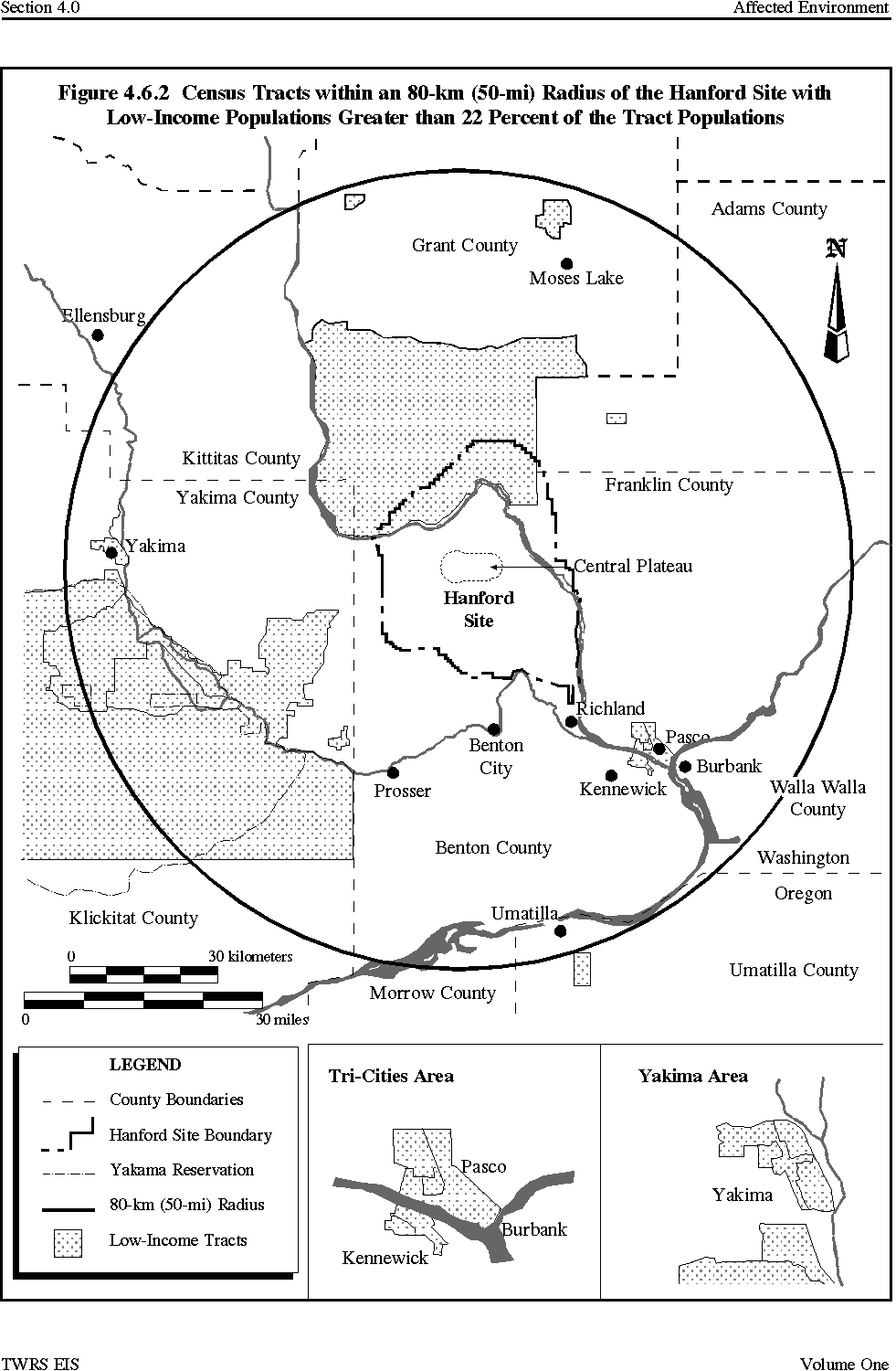
Data on persons and families below the poverty level indicate that for most categories, Benton County has very similar poverty rates to Washington State as a whole (11.1 percent compared to 10.9 percent), while Franklin County has substantially higher poverty rates, at 23 percent of the population. Benton County residents have approximately the same level of educational attainment as residents statewide, while Franklin County residents tend to have a lower level of educational attainment.
4.6.2 Public Facilities and Services
Police protection is provided by the county sheriff departments of Benton and Franklin counties, local municipal police departments (Pasco, Richland, Kennewick, and West Richland), and the Washington State Patrol division in Kennewick. Fire protection in the Tri-Cities area is provided by fire departments in the cities of Kennewick, Pasco, and Richland, a volunteer fire department in West Richland, and three rural fire departments in Benton County. While recent population growth has created additional stress on local public safety agencies' service capabilities, discussions with local government representatives indicated that to date it has not impacted the agencies' ability to adequately serve their jurisdictions. Pasco, Richland, and West Richland indicate that any additional growth will require augmenting public safety agencies' capabilities (McDonald 1995, Milspa 1995, Corcoran 1995). Kennewick's existing agencies could handle modest growth (up to 1,000 additional residents) before additional capabilities are needed (White 1995).
Public safety services are also provided at the Hanford Site. Historically, the Hanford Patrol has provided security and law enforcement services at the Site, although the Benton County Sheriffs Department began providing law enforcement support at the Site in 1994. The Hanford Fire Department has five fire stations onsite and a complement of 155 firefighters (Neitzel 1996) .
There are three major hospitals in the Tri-City area; the Kadlec Medical Center in Richland, Kennewick General Hospital in Kennewick, and Our Lady of Lourdes Hospital in Pasco, all of which operat e at 35 to 50 percent of their capacity ( Neitzel 1996 ). There are also four minor emergency centers in the area. The Hanford Environmental Health Foundation operates five health service centers on the Hanford Site.
Educational services at the primary and secondary levels are provided by four school districts. Kennewick is the largest district, serving approximately 13,000 students in 1994, with 8,700 students in the Richland district, 7,800 students in the Pasco district, and 1,500 students in the Kiona-Benton district. Enrollments have been on the rise over the last few years and all four districts were operating at or near their capacity during the 1994 school year (Cushing 1995). Preliminary data for the 1995 school year show enrollment growth continuing at 2.6 percent in Kennewick, 0.9 percent in Richland, 1.1 percent in Pasco, and 5.1 percent in Kiona-Benton over 1994 levels (Foley 1995, Marsh 1995, Brown 1995, Meilour 1995, and Haun 1995). In 1995, the Richland, Kennewick, and Kiona-Benton districts were operating at capacity, while the Pasco district was at capacity in the primary grades but had more room for secondary students (Neitzel 1996). Post-secondary education in the area is provided by Columbia Basin College (1995 enrollment of 6,700 ) and the Washington State University Tri-Cities branch campus (1995 enrollment of 1,200 ).
Electricity in the Tri-Cities is provided by the Benton County Public Utility District, Benton Rural Electrical Association, Franklin County Utility District, and the city of Richland Energy Services Department. The Bonneville Power Administration, a Federal power marketing agency, supplies all the power that these utilities provide in the local area as well as the Hanford Site's electrical power. Hydroelectric is the region's largest electrical power source. Throughout the 1980's, the Pacific Northwest had more electrical power than it needed and operated with a surplus. This surplus has been exhausted, however, and the regional system generates only enough power to meet regional needs (Neitzel 1996). Natural gas serves only a small portion of the regions residents ( Neitzel 1996 ).
The major incorporated areas of Benton and Franklin counties are served by municipal wastewater treatment systems and the unincorporated areas are served by onsite septic systems. The wastewater treatment systems of the cities of Richland, Kennewick, and Pasco all currently operate well under their capacity (Cushing 1995).
Sanitary waste in the Hanford Site's 200 Areas is currently disposed of through septic tanks and drain fields. There are concerns about the ability of the current system to handle projected sanitary waste disposal needs. Planned construction of a central collection and treatment facility in the 200 Areas was cancelled in 1995 because of funding problems (Harvey 1995).
The city-operated Richland Sanitary Landfill (with a current life expectancy of 50 years), serves Richland and Benton County (Penour 1994). The city of Kennewick contracts for solid waste disposal; city waste is disposed of at a landfill in Arlington, Oregon, which has a life expectancy of approximately 50 years (Denley 1994). The cities of Pasco and West Richland also contract for solid waste disposal; wastes from both communities are taken to a facility in Roosevelt, Washington, which has a life expectancy of 40 years (Thiele 1995).
The existing Hanford Site nonradioactive solid waste landfill is expected to reach its capacity in 1996. In October 1995 it was announced that DOE and the city of Richland reached an agreement to send the Site's nonregulated, nonradioactive solid waste to the Richland Sanitary Landfill (DOE 1995k).
4.6.3 Economy
The Hanford Site is the largest employer in the Tri-Cities area and is a key factor in the local economy. In 1994, total nonfarm employment in the area averaged about 72,300, while Hanford Site employment averaged about 18,400. The Hanford Site thus represents approximately 25 percent of total nonfarm employment in the Tri-Cities. Most Hanford Site employees are considered as part of the services sector of the local economy. In addition, other workers not included in DOE's count of Hanford Site employees provided goods and services to the Site or its contractors.
Nonfarm employment grew to approximately 72,300 in 1994. However, as Hanford Site employment declined in 1995 from 18,100 to 14,500 from August 1994 to August 1995, and as construction employment also declined with a slowdown in housing construction, total nonfarm employment as of August 1995 declined to approximately 70,900 (Schafer 1995a). Agriculture, food processing, retail trade, and other industries provide a considerable and increasing amount of economic diversity to the Tri-Cities area. Farm employment, which fluctuates seasonally, averages a total of nearly 8,000 in the Tri-Cities area. Because farm employment is not impacted by Hanford Site activities it is not discussed further in this section.
4.6.3.1 Industries and Employment
Table 4.6.3 details average annual employment by different sectors of the economy in 1993. The economic sector with the highest employment is services, which includes most of the Hanford Site workforce. The next largest sector is wholesale and retail trade. The Tri-Cities area is the main retailing center for southeastern Washington State and northeastern Oregon. Government is the third largest sector, including Federal, State, and local governments and the public schools. Construction has been a key employment sector in the past few years. Food processing is the largest manufacturing industry, followed by chemicals. The 1995 decline in nonfarm employment previously mentioned most strongly impacted the services sector (which includes most Site employees) and the construction sector.
The services sector dominates the Tri-Cities economy, accounting for $769 million in wages, or about 43 percent of total wages paid in the two counties (WSDES 1994). Statewide, services accounted for
only 21 percent of annual wages paid. The average annual wage in the services sector in Benton County was more than $34,000, compared to $17,000 in Franklin County and $23,000 statewide. The higher annual wage in the services sector in Benton County reflects the Hanford Site-related technical and professional work force.
4.6.3.2 Labor Force
Data for 1990 show that the Benton County labor force is concentrated in the managerial and professional, and the technical, sales, and administrative occupations, each of which accounts for about 30 percent of the work force (WSDES 1994). Franklin County has far lower percentages in these categories.
Table 4.6.3 Average Annual Employment by Sector Tri-Cities Area, 1993 and 1995
Technical, sales, and administrative occupations and farming, forestry, and fishing occupations each account for about 21 percent of the Franklin County labor force. Franklin County also has a higher percentage of workers in the operators, fabricators, and laborers occupational category (17.3 percent) than Benton County (12.0 percent).
Hispanics make up 6.9 percent of the total Benton County labor force, 2.2 percent of the managerial and professional category, 46 percent of the agricultural workers, and 11.9 percent of the operators, fabricators, and laborers category. In Franklin County, Hispanics make up 28.3 percent of the total labor force, 7.2 percent of the managerial and professional occupational category, 63 percent of the agricultural workers, and 28 percent of the precision production, craft, and repair occupational category.
African Americans, who make up 0.9 percent of the labor force in Benton County, account for 1.4 percent of the managerial and professional category, while in Franklin County they account for 2.1 percent of the labor force and 2 percent of the managerial and professional category. Native Americans account for a slightly larger percentage of the service (1.3 percent); precision production, craft, and repair (1.1 percent); and operators, fabricators, and laborers (1.2 percent) categories in Benton County than their percentage of the total labor force (0.7 percent). In Franklin County, Native Americans account for a larger percentage of the managerial and professional (1.1 percent) and precision production, craft, and repair categories (1.5 percent) than in the total labor force (0.8 percent).
Asians and Pacific Islanders account for 2 percent of the labor force in Benton County and 2.7 percent of the managerial and professional category. The same group accounts for 2 percent of the labor force in Franklin County, but only 1.2 percent of the managerial and professional category. Service occupations show the highest rate of Asian and Pacific Islander representation in both counties.
Women account for 40.4 percent of the labor force in Benton County and 42.7 percent in Franklin County. Women account for 51.5 percent of the managerial and professional category in Benton County and 39.4 percent in Franklin County. In the other occupational categories the representation of women is similar in the two counties.
4.6.3.3 Tax Base
Local government revenues in Benton and Franklin counties come primarily from property taxes and the local share of sales taxes (Serot 1993). In 1993, assessed property values were about $3.8 billion in Benton County and $1.3 billion in Franklin County. These assessed values were $500 million more than 1992 assessments in Benton County (15 percent increase) and $86 million more in Franklin County (7 percent increase).
In 1992, the last year for which complete data are available, taxable retail sales in Benton County were $1,054 million and $400 million in Franklin County (WSDR 1993). This was a 14 percent increase in Benton County over 1991 levels and a 16 percent increase in Franklin County. Between 1988 and 1992, combined taxable retail sales for the two counties increased about 10.5 percent per year.
4.6.3.4 Housing and Real Estate
The growth in employment and population in the Tri-Cities area between 1989 and 1994 created a very tight housing market and rising home prices, which began to soften in early 1995 due to reductions in Hanford Site employment (TAR 1980-95). The tight housing market also was reflected in very low vacancy rates and increasing prices in rental housing, although new construction and Hanford Site employment reductions caused a softening of the rental market in 1995 as well (Sivula 1995). The Hanford Site's environmental restoration and waste management mission also stimulated some new commercial construction.
4.7 LAND USE
This section describes current and future land uses on and adjacent to the Hanford Site. The description focuses on the 200 Areas but includes the remainder of the Hanford Site and the surrounding offsite land-use patterns. Also addressed are the future planning efforts of tribes and Federal, State, and local agencies. Prime and unique farmlands and recreational opportunities also are discussed.
4.7.1 Existing Land-Use Types
4.7.1.1 Hanford Site Development Plan and Comprehensive Land-Use Plan
The Hanford Site Development Plan (DOE 1993e) provides an overview of existing Site land use, infrastructure, and facilities, and presents DOE's vision as of 1993 for future Site land uses and infrastructure as needed by Hanford Site missions. A Draft Comprehensive Land-Use Plan for the Hanford Site was release d for public review and comment in August 1996 (DOE 1996c). DOE invited the affected Tribal Nations , county and city government, and stakeholders to participate in the land-use planning process. Final land-use planning decisions are scheduled for 1997.
The purpose of the Site Development Plan, which is not a comprehensive formal land-use plan and does not mandate specific Federal actions, was to present Site development issues that require a commitment of resources. Until the Comprehensive Land-Use Plan is completed, the Hanford Site Development Plan and its Future Land-Use Map (Figure 4.7.1) represent the most currently available document on DOE's concepts for future Site land uses.
Figure 4.7.1 Future Land-Use Map
Figure 4.7.2 identifies the existing land uses on the Hanford Site. The seven major Hanford Site land-use categories are 1) Reactor Operations; 2) Waste Operations; 3) Operations Support; 4) Administrative Support; 5) Research and Development and Engineering Development; 6) Sensitive Areas (including environmentally or culturally important areas); and 7) Undeveloped Areas (both previously undeveloped or restored).
The largest category of existing Hanford Site land use is the Sensitive Areas. Approximately 665 km2 (257 mi2), or nearly half of the Site has been designated as ecological study areas or refuges. This includes the Fitzner Eberhardt Arid Lands Ecology Reserve and the entire Site area north of the Columbia River (the North Slope). Both of these areas are being considered by DOE for release.
Proposals are being considered by DOE to release the Fitzner Eberhardt Arid Lands Ecology Reserve to the Yakama Indian Nation or to another Federal agency such as the Bureau of Land Management.
The North Slope could be designated by Federal legislation as a National Wildlife Refuge, as proposed by the National Park Service (NPS 1994), although other proposals have been made that include some agricultural uses in addition to wildlife areas. A public hearing was held in the summer of 1995 on the Fitzner Eberhardt Arid Lands Ecology Reserve ownership issue, but no final decisions have been made for either area.
The Waste Operations land use is primarily confined to the 200 Areas. The 200 Areas, the focus of proposed TWRS activities, have been used to reprocess irradiated nuclear fuel and to store the resulting waste (including the tank waste). Existing facilities in this area include the PUREX Plant, the Plutonium Finishing Plant, U Plant, the tank farms, the Central Waste Complex, the Waste Sampling and Characterization Facility, and the Waste Encapsulation and Storage Facility. Currently, the PUREX Plant, the Plutonium Finishing Plant, and U Plant are being deactivated.
The Future Land-Use Map from the Hanford Site Development Plan (DOE 1993e) was based on consideration of existing and potential Site missions (Figure 4.7.1). Recommendations of the Hanford Future Site Uses Working Group also were considered (HFSUWG 1992). The Reactor Operations, Sensitive Areas, and Administrative Support areas remain unchanged from the existing land-use map. Of primary importance for the TWRS EIS is the Waste Operations area. The location of the Waste Operations area remains the same, although it has been expanded. This expansion reflects land dedicated to a potential cleanup scenario where Sitewide waste is collected and placed in a central location dedicated to exclusive use as a waste disposal area. This includes relocating waste sites contaminants and associated structures, such as the 100 Area facilities, as well as implementing the proposed TWRS action.
The Hanford Site Development Plan future land-use concept is designed to provide a compatible land-use transition from offsite agricultural uses in Adams, Grant, Franklin, and Benton counties to passive uses onsite in the Fitzner Eberhardt Arid Lands Ecology Reserve and the proposed National Wildlife Refuge and Wild and Scenic River north of and along the Columbia River. The areas of the Hanford
Figure 4.7.2 Hanford Site Existing Land-Use Map
Site nearest to the river are proposed in the Hanford Site Development Plan to remain undeveloped, providing an additional buffer area between sensitive natural areas and more intensely developed Site uses such as on the Central Plateau. The Hanford Site Development Plan accommodates future intensive uses, such as industrial development and research, in the southeast area of the Hanford Site near the urban development of Richland. Although in the Hanford Site Development Plan the Undeveloped Areas were reduced in size to reflect the future release and reuse of portions of the Hanford Site, DOE is working with various government agencies and other organizations to ensure proper preservation, protection, and management of sensitive ecological and cultural resources.
In 1994, the U.S. Department of Interior recommended that Congress designate the Hanford Reach of the Columbia River as a Recreational River under the Wild and Scenic Rivers Act and also designate the area north and east of the river as a National Wildlife Refuge (NPS 1994). This proposal would transfer management of the river and a 0.40-km (0.25-mi) strip of land along both shores of the river, along with approximately 40,000 ha (100,000 ac) of adjacent lands, to the U.S. Fish and Wildlife Service. Development restrictions would be included for the protection of cultural resources, threatened and endangered species, water quality, unique scenic geologic features, and Native American access and use. Benton, Franklin, and Grant county commissioners oppose designation of the Hanford Reach under the Wild and Scenic Rivers Act and have offered an alternative proposal that would leave the Hanford Reach under local government control. Other local groups (e.g., the Lower Columbia Basin Audubon Society) and local residents support the designation. No final decisions have been made on this issue.
The Bureau of Land Management owns land on the Hanford Site that was withdrawn from the public domain for national security use. Currently, the Bureau of Land Management does not own any lands on the Central Plateau because of land exchanges with the Atomic Energy Commission in the 1960's. The Bureau of Land Management owns the land on which the potential Vernita Quarry borrow site is located.
4.7.1.2 Washington State Land Uses
Washington State has several land interests on the Hanford Site. The Washington State Department of Fish and Wildlife currently administers the area of the Hanford Site north and east of the Columbia River known as the Wahluke State Wildlife Recreation Area. This area is considered sensitive ecological upland habitat. Washington State also leases a square parcel in the south central portion of the Hanford Site between State Route 240 and the Route 2 and Route 4 junction. This property is located within the Undeveloped Area of the Site.
4.7.1.3 Tribal Nation Land Uses
The Hanford Site is located on land ceded to the United States by the Confederated Tribes and Bands of the Yakama Indian Nation and the Confederated Tribes of the Umatilla Reservation in the treaties of 1855 (DOI 1992). The Nez Perce Tribe also has retained certain treaty rights to the Columbia River under a separate treaty with the U.S. Government.
4.7.1.4 Local Government Land Uses and Land-Use Plans
The Hanford Site is located within portions of Benton, Franklin, Grant, and Adams counties. Other surrounding local jurisdictions include the cities of Richland, West Richland, Pasco, and Kennewick. Many of the local jurisdictions existing comprehensive plans are incomplete or outdated and updates are either in progress or recently completed. Both Benton County and the city of Richland are currently involved in land-use planning efforts for the Hanford Site, with the Richland effort focusing only on the southern portions of the Site that are within the city's urban growth boundaries (e.g., the 300 and 1100 Areas).
The majority of the Hanford Site is located within Benton County; the Site makes up 25 percent of the county land. The cities of Richland, West Richland, Kennewick, Prosser, and Benton City are located within Benton County. The unincorporated areas of the county adjacent to the Hanford Site currently have generalized land-use designations for rangeland (largely cattle grazing), undeveloped (primarily open space), and dry agriculture (almost entirely dry land wheat) (BCBCC 1985). Benton County is in the process of updating its comprehensive plan and is expected to release a recommended plan in mid-1996 and make final decisions in late 1996 or early 1997 (Stang 1995a). The plan update will include a separate Hanford Comprehensive Plan that will be consistent with the overall County plan (Walker 1995).
Franklin County, located east of the Hanford Site, includes the city of Pasco. The unincorporated area of the county adjacent to the Hanford Site is rural and sparsely developed. The land-use designation surrounding the Site, as with most of the county, is agriculture. Franklin County adopted an updated comprehensive plan in April 1995. The update does not directly impact land uses at the Hanford Site (German 1995).
Grant County contains the area of the Site north of the Columbia River. The land uses adjacent to the Site are designated as agriculture. Grant County is in the process of updating its comprehensive plan but the expected date for its completion is in 1998 . No changes in the comprehensive plan would affect any areas of the Hanford Site that are south and west of the Columbia River, including any potential TWRS areas (Lambro 1995).
The city of Richland, located immediately adjacent to the Hanford Site, is currently in the process of annexing the Hanford Site's 1100 Area (Milspa 1995). The existing land uses within Richland near the Hanford Site include industrial, agricultural, and public lands. The planned land-use designation within the Richland area adjacent to the Site is identified as industrial, which is compatible with the adjacent Hanford Site use (City of Richland 1988). The city develop ed a set of alternatives for its updated comprehensive plan, which was released for public review in March 1996 . The comprehensive plan itself is expected to be adopted by the city in early 1997 . The updated plan would be expected to call for maintaining and expanding industrial and research and development activities in the area of the city adjacent to the Site (Milspa 199 6 ).
West Richland is a developing residential community south of the Hanford Site. The West Richland land use near the Site is designated low density residential, which is consistent with the nearby existing Hanford Site land uses (Fitzner Eberhardt Arid Lands Ecology Reserve and Undeveloped Area). The West Richland comprehensive plan was released in June 1996 and is expected to be adopted by the city in September 1996 . There is very little in the plan that would impact Site land-use issues (Corcoran 1996 ).
The cities of Pasco and Kennewick are also located near the Hanford Site. Pasco is planning major commercial, industrial, office, and residential improvements along the U.S. Interstate 182 corridor to attract businesses. Pasco adopted its updated comprehensive plan in August 1995. There is very little in the update related to Hanford Site land uses (McDonald 1995). Like Pasco, Kennewick is planning additional industrial and office areas to attract businesses. Kennewick adopted its updated comprehensive plan in April 1995. Very little in the plan is related to Site land uses (White 1995).
4.7.1.5 Natural Resources Trustee Council
The Natural Resources Trustee Council is composed of representatives from Washington State and Oregon, Federal agencies (DOE and the Department of Interior), and three affected Tribal Nations (Yakama Indian Nation, Confederated Tribes of the Umatilla Indian Reservation, and Nez Perce Tribe). The primary purpose of the Council is to facilitate the coordination and cooperation of the trustees in their efforts to restore and minimize impacts to natural resources injured as a result of or during cleanup of releases associated with DOEs activities at the Hanford Site. The Councils primary role with respect to TWRS will be to coordinate with DOE during development of the Mitigation Action Plan for impacts identified in the TWRS EIS.
4.7.2 Prime and Unique Farmland
The Farmland Protection Policy Act requires Federal agencies to consider prime or unique farmlands when planning major projects and programs on Federal lands (7 CFR 657.4). Federal agencies are required to use prime and unique farmland criteria developed by the U.S. Department of Agriculture Soil Conservation Service. The Soil Conservation Service has determined that due to low annual precipitation in southeast Washington State, none of the soil occurring on the Hanford Site would meet prime and unique farmland criteria without irrigation (Brincken 1994).
4.7.3 Recreational Resources and the National Environmental Research Park
For the purposes of wildlife management and outdoor recreation, some portions of the Hanford Site are administered by agencies other than DOE. In 1976, the entire Hanford Site was designated by DOE as a National Environmental Research Park aimed at original research into the ecology and natural resources of the area (NPS 1994). Nearly one-half of the Hanford Site is designated for wildlife management use. These wildlife management areas buffer developed areas of the Hanford Site. The area where the Columbia River flows through the Hanford Site is identified as the Hanford Reach and has been proposed as a Recreational River. None of the recreational and wildlife areas are near the TWRS sites in the 200 Areas. They are briefly discussed in the following text and shown on Figure 4.7.3.
Figure 4.7.3 Recreation and Wildlife Areas and the Hanford Reach
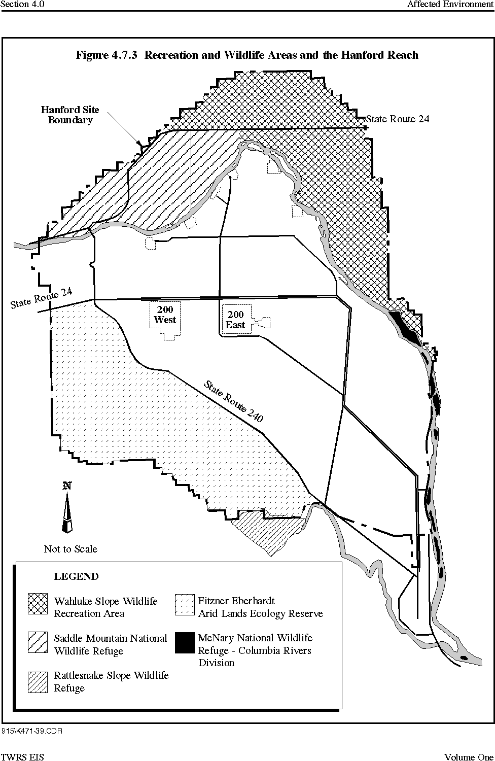
- Fitzner Eberhardt Arid Lands Ecology Reserve - Located in the southwest corner of the Hanford Site, the 310-km2 (120-mi2) reserve is managed as an ecological research resource for DOE by Pacific Northwest National Laboratory. DOE consider ed a proposal from the Bureau of Land Management to exchange sections of DOE lands on the Reserve for Bureau of Land Management-owned lands elsewhere on the Hanford Site. The Yakama Indian Nation also proposed taking over the Reserve, as did Benton County (Stang 1996a). In July 1996, DOE notified the Yakama Indian Nation, other Federal Agencies, and Benton County of its decision to keep control of the Reserve (O'Leary 1996). The Reserve will continue to function as a buffer zone for on going waste management in the 200 Areas. DOE also announced its intention to negotiate an agreement with the U.S. Fish and Wildlife Service to manage the Reserve while protecting the environmentally sensitive areas and allowing greater public access (Stang 1996c.)
- McNary National Wildlife Refuge - The Refuge's 140-ha (350-ac) Hanford Islands Division contains six islands in the Columbia River (upstream of the city of Richland) which are within the boundaries of the Hanford Site.
- Saddle Mountain National Wildlife Refuge - The U.S. Fish and Wildlife Service manages the Saddle Mountain Refuge, located on the Hanford Site north and west of the Columbia River and a narrow strip of land south and west of the river. Currently, the area is closed to all public use and is dedicated to wildlife management.
- Wahluke Wildlife Recreation Area - Located on the Hanford Site north and east of the Columbia River, the area is managed by the Washington State Department of Fish and Wildlife and is open for public recreation.
- Rattlesnake Slope Wildlife Refuge - The Refuge is located adjoining the Fitzner Eberhardt Arid Lands Ecology Reserve's southern boundary. The Refuge, which is managed by the State of Washington, is outside the boundary of the Hanford Site.
- The Hanford Reach of the Columbia River - The Hanford Reach, which is the last free-flowing segment of the Columbia River in the United States, extends 80 km (50 mi) and includes those portions of the Columbia River within the boundaries of the Hanford Site. Under the National Park Service proposal to designate the Hanford Reach as a Recreational River, the least restrictive designation under the Wild and Scenic Rivers Act, the Hanford Reach boundaries would include a 0.4-km (0.25-mi) strip of land on each side of the river, the Saddle Mountain National Wildlife Refuge, and the Wahluke Wildlife Recreation Area. Under the National Park Service proposal, all public lands within the proposed boundary would be transferred to the U.S. Fish and Wildlife Service, which would be the administrating agency. Benton, Franklin, and Grant county commissioners oppose this designation and have proposed an approach that leave the Reach under local government control, although there also are local residents and groups (e.g., the Lower Columbia Basin Audubon Society) that support the designation of the Hanford Reach as a Wild and Scenic River (Stang 1996b).
The Hanford Reach and adjacent wildlife refuge and recreation areas provide a variety of recreational activities year-round for local residents and visitors. The most popular activities are sport fishing, boating, and waterfowl hunting. Other popular activities include waterskiing, upland hunting, and nature observation. The heaviest use occurs during September and October, coincident with autumn chinook salmon runs (NPS 1994).
Because of restricted use of the Hanford Site and Saddle Mountain National Wildlife Refuge lands, virtually all land-based recreation occurs on the Wahluke Wildlife Recreation Area. Total recreational use of the Hanford Reach comprises approximately 10,000 land-based visits by hunters, trappers, and nonconsumptive users and approximately 40,000 visits by water-based users (predominantly anglers) per year (NPS 1994).
4.8 VISUAL RESOURCES
The following paragraphs describe the existing visual environment that would be modified by TWRS project implementation.
4.8.1 Landscape Character
The landscape setting within the Hanford Site region is characterized by broad basins and plateaus interspersed with ridges. However, the wide open vistas throughout much of the area are interrupted by over a dozen large industrial facilities (e.g., reactors, processing facilities). Only about 6 percent of the Hanford Site has been disturbed; the remainder of the Hanford Site is undeveloped, including natural areas and abandoned agricultural lands that remain undisturbed because of restricted public access.
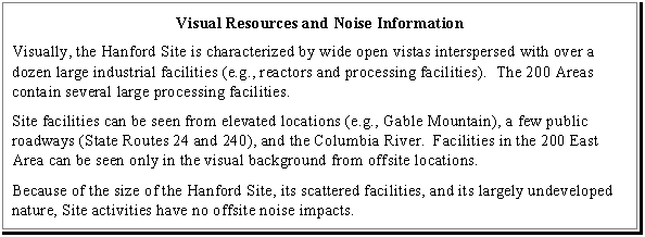
The major landscape feature of the Hanford Site is the Columbia River, which flows through the northern part of the Hanford Site and then turning south, forms the eastern Site boundary. Yakima Ridge and Umtanum Ridge form the western boundary of the Site. Two small east-west ridges (Gable Butte and Gable Mountain) rise above the Central Plateau, the large open plateau where TWRS activities would be focused under all EIS alternatives.
The potential Vernita Quarry borrow site is located adjacent to the east of State Route 24 in the northwest of the Hanford Site. The potential McGee Ranch borrow site is located in slightly rolling terrain in the northwest of the Hanford Site just west of State Route 24.
4.8.2 Potential Viewing Areas
For purposes of study, viewing areas are generally divided into four distance zones: the foreground, within 0.8 km (0.5 mi); the middleground, from 0.8 to 8 km (0.5 to 5 mi); the background, from 8 to 24 km (5 to 15 mi); and seldom seen areas that are either beyond 24 km (15 mi) or are unseen because of topography (Figure 4.8.1).
Hanford Site facilities can be seen from elevated locations such as Gable Mountain, Gable Butte, Rattlesnake Mountain, and other portions of the Rattlesnake Hills along the Hanford Site's western perimeter. Gable Mountain, Gable Butte, and Rattlesnake Mountain are used by Native Americans for religious purposes. Site facilities also are visible from offsite locations including State Routes 240 and 24 and the Columbia River. Because of terrain features, distances involved, the size of the Hanford Site, and the size of individual facilities, not all facilities are visible from the highways or the Columbia River.
Facilities in the 200 East Area are in the interior of the Hanford Site and cannot be seen from the Columbia River or State Route 24. Large facilities in the 200 East Area are visible from State Route 240 only as distant background (more than 8 km [5 mi] away). Facilities in the 200 West Area can be seen by travelers on an 11-km (7-mi) segment of State Route 240 south of the Yakima Barricade. For these viewers the facilities are in the visual middleground (0.8 to 8 km [0.5 to 5 mi] away). Facilities in the 200 West Area cannot be seen from the Columbia River. Facilities throughout the 200 Areas are visible from elevated locations such as Gable Mountain and Gable Butte.
The potential Vernita Quarry borrow site is located adjacent to State Route 24 west and north of the Central Plateau. Much of the basalt resources contained in exposed basalt cliffs and past quarry operations are highly visible from the highway. The potential McGee Ranch borrow site activities would be located a short distance from the nearest public highway (State Route 24) in slightly rolling terrain. Borrow activities would be visible from the highway. The potential Pit 30 borrow site is located between the 200 East and 200 West Areas and is only visible from elevated locations.
4.9 NOISE
Noise conditions produced by current, routine operations at the Hanford Site do not violate any Federal or Washington State standards (Washington Administrative Code 173-60). Even near the operating facilities along the Columbia River, measured noise levels are lower than noise experienced in parts of the city of Richland (less than 52 decibels on the A scale (dBA) versus 61 dBA) (dBA is a noise scale used to describe sounds in the frequencies most readily detected by human hearing) (Nuclear Regulatory Commission 1982). Noise levels measured near intake structures at the Columbia River are well within the 60-dBA tolerance levels for daytime residential use. Five kilometers (3 mi) upstream of the intake structures, measured noise levels fall well within levels suited for daytime and nighttime residential use. Moreover, the relative remoteness of population centers from the Hanford Site as a whole (and the TWRS sites in particular) gives the Site a Class C (industrial) classification with a maximum allowable equivalent sound level of 70 dBA in compliance with Washington State and Federal standards (DOE 1991 and Cushing 1992). The equivalent sound level integrates noise levels over time and expresses them as continuous sound levels. Native Americans have expressed the concern that Hanford Site religious locations such as Gable Mountain are near enough to TWRS areas to potentially be impacted by TWRS activities (CTUIR 1996).
Figure 4.8.1 Potential Viewing Areas of 200 East and 200 West Areas
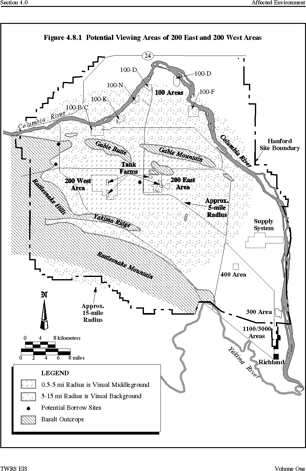
4.10 TRANSPORTATION
The majority of air passenger and freight services in the local area goes through the Tri-Cities Airport, located in Pasco (Cushing 1992). Both Richland and Kennewick have small airports serving general aviation. The ports of Benton, Kennewick, and Pasco use the commercial waterways of the Snake and Columbia rivers to provide access to the deep-water ports of Portland, Oregon and Vancouver, Washington.
Direct rail service is provided to the Tri-Cities area by the Burlington Northern and Union Pacific Railroads. The rail system on the Hanford Site itself consists of approximately 210 km (130 mi) of tracks. It extends from the Richland Junction (at Columbia Center in Kennewick) where it joins the Union Pacific commercial railroad track, to an abandoned commercial right-of-way near the Vernita Bridge in the northwest portion of the Site. There are currently about 1,400 railcar movements annually Sitewide, transporting a wide variety of materials including coal, fuels, hazardous process chemicals, and radioactive materials and equipment. Radioactive waste has been transported on the Site without incident for many years (DOE 1995i).
Regional road transportation is provided by a number of major highways including State Routes 24 and 240 and U.S. Interstate Highways 82 and 182 (Cushing 1992). State Routes 24 and 240 are both two-lane roads that traverse the Hanford Site. State Route 24 is an east-west highway that turns north at the Yakima Barricade in the northern portion of the Site. State Route 240 is a north-south highway that skirts the eastern edge of the Fitzner Eberhardt Arid Lands Ecology Reserve (Figure 4.10.1).
A DOE-maintained road network within the Hanford Site, mostly paved and two-lanes wide, provides access to the various work centers. The primary access roads on the Site are Routes 2, 4, 10, and 11A. Primary access to the 200 Areas is by Route 4 South from Richland. The 200 East Area is also accessed from Route 4 North off Route 11A from the north. July 1994 traffic counts on Route 4 indicated severe congestion west of the Wye Barrier (at the intersection of Routes 10 and 4 South) during Hanford Site shift changes (WHC 1994c). However, completing the State Route 240 Access Highway (Beloit Avenue) linking the 200 Areas with State Route 240 in late 1994 and declining Hanford Site employment have reduced the congestion on Route 4 (Rogers 1995).
Figure 4.10.1 Hanford Site Roadway and Railroad System
Stevens Road at the 1100 Area leading into the Site from Richland (Stevens Road becomes Route 4 South further north onsite) also has experienced severe congestion (BFRC 1993). The 240 Access Highway completion and reduction of Hanford Site employment have reduced this congestion somewhat, although no specific traffic count data are available to quantify this assessment (Rogers 1995).
Access to the 200 West Area is also provided from Route 11A for vehicles entering the Site through the Yakima Barricade and from Route 6 off Route 11A from the north. No congestion problems are reported on these roadways.
Public access to the 200 Areas and interior locations of the Hanford Site has been restricted by manned gates at the Wye Barricade and the Yakima Barricade (at the intersection of State Route 240 and Route 11A).
4.11 RADIOLOGICAL ENVIRONMENT: OVERVIEW AND POTENTIAL RADIATION DOSES FROM 1995 HANFORD SITE OPERATIONS
This section provides a brief introduction to the subject of radioactivity and to some of the common terms used in radiological health evaluation. It also summarizes 1995 data on radiation doses from operations at the Hanford Site and the potential future fatal cancers attributable to exposures.
4.11.1 Introduction to Radioactivity
Radioactivity is a broad term that refers to changes in the nuclei of atoms that release radiation. The radiation is an energetic ray or energetic particle. For ionizing radiation, the ray or particle has enough energy to cause changes in the chemical structure of the materials it strikes. These chemical structure changes are the mechanisms by which radiation can cause biological damage to humans. This means that a human body cell may be damaged if it comes into contact with the energy from a particle or ray released by radioactive decay.
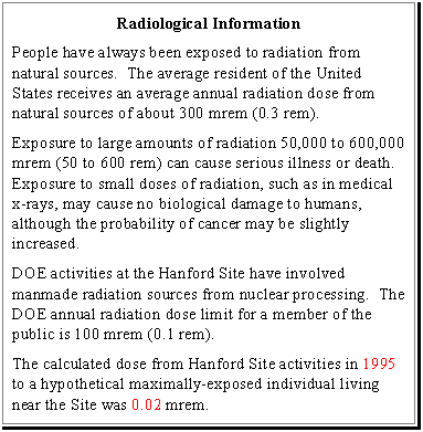
Radiation comes from many sources, some natural and some human-made. People have always been exposed to natural or background radiation. Natural sources of radiation include the sun, and radioactive materials present in the earth's crust, in building materials and in the air, food, and water. Natural radioactivity can even be found within the human body. Some sources of ionizing radiation have been created by people for various uses or as by-products of these activities. These sources include nuclear power generation, medical diagnosis and treatment, and nuclear materials related to nuclear weapons.
Radioactive waste is a result of the use and production of radioactive materials. At the Hanford Site, DOE manages radioactive waste that was generated primarily by the production of plutonium for nuclear weapons. This waste is classified as low-activity, high-level, or transuranic. When radioactive waste is combined with hazardous chemical waste, it is referred to as mixed waste. High-level waste is the most dangerous type of radioactive waste and requires extensive shielding by materials such as lead, water, or concrete and special remote, noncontact handling. Transuranic waste is material contaminated with radioactive elements heavier than uranium. While long lasting, transuranic waste does not require the same degree of isolation as high-level waste. Low-activity waste is generally the least dangerous type of radioactive waste and requires fewer measures to isolate it from people and the environment.
Radioactive waste can be harmful and thus requires isolation for up to hundreds or even thousands of years. Plutonium-contaminated waste will be radioactive for thousands of years. Radioactive cesium, on the other hand, will be virtually gone in 300 years.
4.11.2 Common Terms in Radiological Health Evaluations
Radiation dose to individuals is usually expressed in rem or millirem (mrem), which is one-thousandth of a rem. The rem is a measure of the biological effects of ionizing radiation on people. It is estimated that the average individual in the United States receives an annual dose of about 300 mrem (0.3 rem) from all natural sources. The collective radiation dose to a population, which is calculated by adding up the radioactive dose to each member of the population, is expressed in person-rems.
Any dose of radiation potentially can cause damaging changes to body cells. However, at low levels, such as those received from a medical x-ray, the damage to cells is so slight that the cells can repair themselves or can be replaced by the regeneration of healthy cells. Radiation exposures are often classified as acute (a dose received over a short time), or chronic (a dose received over a long time). Chronic doses are usually less harmful than acute doses because the body has time to repair or replace damaged cells. Nevertheless, even chronic or low doses can have potentially harmful effects.
Impacts from radiation exposure often are expressed using the concept of risk. The most important radiation-related risk is the potential for developing cancers that may cause death in later years. This delayed effect is measured in latent (future) cancer fatalities. The risk of a latent cancer fatality is estimated by converting radiation doses into possible numbers of cancer fatalities. For an entire exposed population group, the latent cancer fatality numerical value is the chance that someone in that group would develop an additional cancer fatality in the future because of the radiation exposure, (i.e., a cancer fatality that otherwise would not occur).
Radiological risk evaluations often refer to the maximally-exposed individual. This is the hypothetical member of the public or a worker who would receive the highest possible dose in a given situation. As a practical matter, the maximally-exposed individual likely would be a person working with radiological or hazardous materials. The Federal government has set a maximum annual exposure limit for workers of 5,000 mrem (5 rem) while DOE has an Administrative Control Limit of 2,000 mrem (2 rem) for occupational exposure. DOE's limit for annual radiological exposures to the public from DOE activities is 100 mrem (0.1 rem).
4.11.3 Potential Radiation Doses and Latent Cancer Fatalities from 1995 Hanford Site Operations
Each year the potential radiation doses to the public from Hanford Site radiation sources are calculated as part of the Hanford Site Environmental Monitoring Program. In particular, the dose to the hypothetical maximally-exposed individual is calculated as described in the Hanford Site Environmental Report for Calendar Year 1995 (PNL 1996 ). This hypothetical maximally-exposed individual is assumed to live at a location where the radiation dose from airborne releases would be larger than for a resident of any other offsite location. The maximally-exposed individual also is assumed to get drinking water from the Columbia River; eat food grown with Columbia River irrigation water; and use the river extensively for boating, swimming, and fishing (including eating fish from the river). The exposure calculation for this hypothetical individual is based on Hanford Site data from actual reported releases, environmental measurements, and information about operations at Hanford Site facilities.
The calculated dose in 1995 to the maximally-exposed individual near the Hanford Site was a total of 0.02 mrem compared to 0.05 mrem reported for 1994 (PNL 1996) . As indicated previously, the DOE radiation dose limit for a member of the public is 100 mrem. Thus, the 1995 total dose to the maximally-exposed individual was far below the limit. The U.S. Environmental Protection Agency regulations impose a dose limit of 10 mrem to a member of the public from radioactivity released in airborne effluents. The 1995 Hanford Site airborne dose to the maximally-exposed individual of 0.006 mrem was far below the U.S. Environmental Protection Agency limit.
To estimate health effects for radiation protection purposes, it usually is assumed that a collective dose of 2,000 person-rem in the general population will cause one extra latent cancer fatality (ICRP 1991). In these calculations, it does not matter whether 20,000 people each receive an average of 0.1 rem or 2 million people each receive an average of 0.001 rem. In either case the collective dose would equal 2,000 person-mrems and thus one additional latent cancer facility would be expected. The 1995 collective dose to people surrounding the Hanford Site from Hanford Site releases was calculated to be 0.3 person-rems , which is lower than the 0.6 mrem calculated for 1994 . Compared to 2,000 person-rems causing one extra latent cancer fatality, the 0.3 person-rems from the Hanford Site in 1995 is not likely to cause any latent cancer fatalities.
|
NEWSLETTER
|
| Join the GlobalSecurity.org mailing list |
|
|
|