


B.6.0 THE HANFORD BARRIER
This section describes the multi-layered barrier, or Hanford Barrier, which is included in all alternatives that include closure activities as a representative surface barrier (cap) for closure as a landfill.
The Hanford Barrier would be a horizontal, multi-layered above grade engineered soil structure whose function would be to isolate the waste site from the environment by preventing or reducing the likelihood of wind erosion, water infiltration, and plant, animal, and human intrusion. It would be composed of 10 layers, with a combined thickness of 4.5 m (14.8 ft), and placed over the top of the stabilized tanks and the LAW disposal sites. Each Hanford Barrier would extend an additional 9 m (30 ft) beyond the perimeter of the area to be protected. Performance objectives of the Hanford Barrier system would include the following:
- Function in a semi-arid to sub-humid climate;
- Limit the amount of water migration through the waste to near zero amounts;
- Be maintenance free;
- Minimize the likelihood of intrusion by plants, animals, or people;
- Limit the amount of gases released;
- Minimize erosion;
- Meet or exceed RCRA cover performance requirements;
- Isolate waste for a minimum of 1,000 years; and
- Be acceptable to regulators and the public.
B.6.1 DESCRIPTION OF THE BARRIER LAYERS
The layers of the barrier are described from the top down. The Hanford Barrier design is provided in Figure B.6.1.1.
Figure B.6.1.1 Hanford Barrier
Top Vegetative Cover
The top vegetative cover would be for water retention and removal. Five species of perennial grasses would be planted across the barrier top. Seeding would include disking the soil, applying granular fertilizer, and seeding with a perennial grass mixture. To help establish cover grass, the site would be mulched with straw, which would be crimped into the soil to minimize wind erosion until the vegetation cover is developed.
Top (First and Second) Barrier Layers
The first barrier layer would consist of topsoil with a pea-gravel mixture; the second layer would consist of topsoil without pea-gravel. The first layer would be 1 m (3.3 ft) of sandy silt to silt loam soil with a 15 percent by weight admixture of pea-gravel. This layer would be placed loosely with a bulk density of 1.46 grams(g)/cm3 (18.7 pounds [lb]/ft3). The second layer would have the same type of topsoil; however, the bulk density would be approximately 1.38 g/cm3 (86 lb/ft3). These two layers would manage water by storing precipitation, providing a media for the growth of cover vegetation, and allowing evaporation and transpiration by the cover plants. The proposed topsoil would be obtained from a borrow site.
Third Barrier Layer
The third layer would be a geotextile, used primarily to separate topsoil layers from the sand filtration layer. After construction is completed, this geotextile would no longer have a specific function and therefore its long-term durability is not an issue.
Fourth and Fifth Barrier Layers
The fourth layer would be a sand filter, and the fifth layer would be a gravel filter. The purpose of these two layers would be to prevent migration and accumulation of fine-textured topsoil in the basalt layer. A capillary barrier, which occurs when a layer of fine-textured soil overlays a layer of coarser-textured soil (e.g., sand, gravel, or rock), would be created at the interface between the geotextile and the fourth layer (sand filter). Surface tension effects within the pore space of fine-textured soil would exert a negative pressure on the contained soil moisture. For moisture to drain out of fine-textured soil, surface tension would have to be overcome by developing gravitational pressure (hydraulic head) within the layer. In effect, some portion of the full thickness of this fine-soil layer will have to become completely saturated before drainage could occur. The sand filter would be 0.15 m (0.5 ft) deep, and the gravel filter would be 0.3 m (1 ft) deep. Both layers would be obtained from a borrow site.
Sixth Barrier Layer
The sixth layer would be constructed of coarse basalt smaller than 25 by 5 cm (10 by 2 in.). The basalt layer would control biointrusion from plant roots, burrowing animals, and humans. The basalt would impede exploratory drilling. A subsurface layer consisting of loose fractured rock would pose a particularly adverse drilling condition for the following reasons:
- Circulation could not be maintained;
- Cuttings could not be adequately removed from the hole;
- The drill bit could not receive adequate lubrication; and
- Firm contact could not be maintained between the bit and the rock.
All of these factors would contribute to high bit wear and minimum advance of the drill hole. In addition, the layer would prevent moisture retention because large void spaces will enable water to drain into the seventh layer.
Seventh Barrier Layer
The seventh layer would be for lateral drainage. It would consist of screened material having a diameter of 1 millimeter (mm) (0.04 in.) or greater, which would give a hydraulic conductivity of at least 1 cm/sec (0.4 in./sec). This layer is part of contingency planning; any water draining to the seventh layer would be collected and/or diverted to the edge of the cover because of the 2 percent slope. This layer would be approximately 4 m (13 ft) below final grade to protect against frost penetration.
Eighth Barrier Layer
The eighth layer would consists of asphalt that would serve as a low-permeability barrier and as a secondary biointrusion barrier. The asphalt would be a durable asphaltic concrete mixture consisting of double-tar asphalt with added sand as a binder material. This layer would be 0.15 m (0.5 ft) thick with a hydraulic conductivity of approximately 1.0E-8 cm/sec. Natural analog studies estimate that this asphalt could remain functional for a period of 5,000 years or more as long as the asphalt remains covered and protected from ultraviolet radiation and freeze and thaw activity. To provide additional protection against leakage, the asphaltic concrete would be coated with a sprayed asphaltic coating material, which would be puncture-resistant, flexible, and easy to apply. The asphaltic coating material would have a permeability value of about 1.0E-11 cm/sec.
Ninth Barrier Layer
The ninth layer would be an asphalt base course that would provide a stable base for constructing the asphalt layer.
Tenth Barrier Layer
The tenth layer would contain grading fill that would establish a smooth, planar base surface for constructing the barrier layers. The sites covered by the Hanford Barrier would be contoured and graded for a uniform slope of 2 percent.
Locations to be Covered
The following locations would be covered with a Hanford Barrier:
- Tank Farm A (SST 6 tanks): 0.86 hectares (ha) (2.13 acres [ac]);
- Tank Farm AN (DST 7 tanks): 1.30 ha (3.21 ac);
- Tank Farm AP (DST 8 tanks): 1.17 ha (2.89 ac);
- Tank Farm AW (DST 6 tanks): 0.91 ha (2.26 ac);
- Tank Farm AX (SST 4 tanks): 0.63 ha (1.55 ac);
- Tank Farm AY (DST 2 tanks): 0.37 ha (0.92 ac);
- Tank Farm AZ (DST 2 tanks): 0.37 ha (0.92 ac);
- Tank Farm B (SST 16 tanks): 1.85 ha (4.57 ac);
- Tank Farm BX (SST 12 tanks): 1.54 ha (3.80 ac);
- Tank Farm BY (SST 12 tanks): 1.55 ha (3.84 ac);
- Tank Farm C (SST 16 tanks): 1.89 ha (4.68 ac);
- Tank Farm S (SST 12 tanks): 1.57 ha (3.89 ac);
- Tank Farm SX (SST 15 tanks): 1.91 ha (4.72 ac);
- Tank Farm SY (DST 3 tanks): 0.65 ha (1.61 ac);
- Tank Farm T (SST 16 tanks): 1.85 ha (4.57 ac);
- Tank Farm TX (SST 18 tanks): 2.46 ha (6.09 ac);
- Tank Farm TY (SST 6 tanks): 0.87 ha (2.16 ac);
- Tank Farm U (SST 16 tanks): 1.89 ha (4.67 ac); and
- LAW disposal vault.
B.6.2 SUMMARY OF BORROW SITES AND BORROW MATERIALS
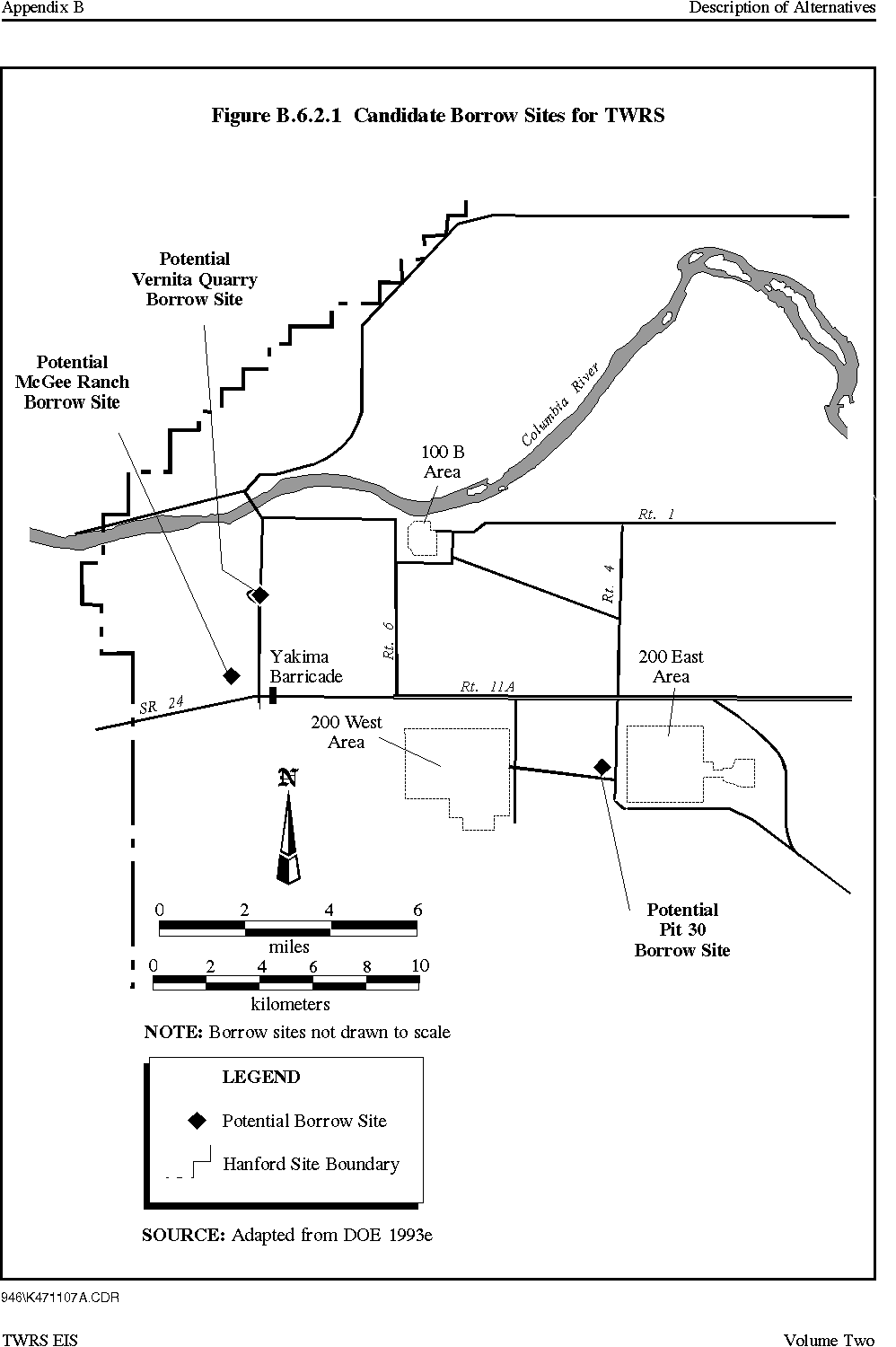
There are three sites assumed in the engineering data packages for borrow materials. These are Pit 30, which would supply sand and aggregate; the Vernita Quarry, which would supply riprap; and McGee Ranch, which would supply silt. These areas are also potential borrow sites. A decision on exactly which borrow site would be used and to what extent they would be used would be made through future NEPA analysis . The following is a brief description of the location and estimated distance of the potential borrow sites used for calculation purposes .
These potential borrow sites have been evaluated previously (BHI 1995) with respect to site proximity, availability of borrow material, transportation, safety, and land reclamation. This preliminary analysis indicated that all the potential borrow sites were suitable sources of borrow material. Figure B.6.2.1 shows the location of the proposed borrow sites.
Figure B.6.2.1 Potential Borrow Sites for TWRS
Pit 30
The potential Pit 30 borrow site is an existing and established borrow pit, located approximately centrally with respect to the 200 Areas. The estimated haul distance is 10 km (6 mi) round-trip to the 200 East and 200 West Areas.
Vernita Quarry
The potential Vernita Quarry borrow site is located east of State Route 24 near the Vernita Bridge. It was probably originally used to support highway construction. Distance estimates (one-way) are 12 km (7 mi) from the 200 West Area and 19 km (12 mi) to the 200 East Area.
McGee Ranch
The potential McGee Ranch borrow site is located west of State Route 24 and north of Route 11A. Distance estimates (one-way) are 11 km (6.5 mi) to the 200 West Area and 18 km (11 mi) to the 200 East Area.
Borrow Material Quantities
The estimated quantities of borrow materials taken from the various engineering data packages are shown on the following three tables. Table B.6.2.1 shows borrow materials used during construction and operation for the alternatives. Table B.6.2.2 shows borrow materials that are estimated for backfilling the empty tanks for all of the ex situ alternatives. Table B.6.2.3 shows the data for borrow materials used in the construction of the multi-layered barriers (Hanford Barriers), which may be placed over the tanks and vaults. In this table, each group of alternatives uses the same quantity of borrow materials.
Table B.6.2.1 Borrow Site Summary - Materials Used During Construction and Operations
Table B.6.2.3 Borrow Site Summary - Materials Used for Construction of Hanford Barriers
|
NEWSLETTER
|
| Join the GlobalSecurity.org mailing list |
|
|
|