


APPENDIX G FLOODPLAIN AND WETLANDS ASSESSMENT
G.1 INTRODUCTION
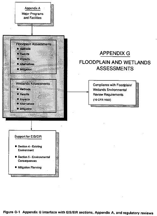
This appendix is prepared to provide an analysis of the potential impacts on floodplains and wetlands from the proposed action and the alternatives (see Section 3 of the EIS/EIR). It is also prepared to demonstrate compliance with DOE's policy of avoiding, as much as possible, adverse impacts to floodplains and wetlands located at its facilities. G-1 illustrates the relationship of Appendix G to other EIS/EIR appendices, sections of the text, and DOE requirements.
The Floodplain and Wetlands Assessment is prepared pursuant to the U.S. Department of Energy's (DOE) "Compliance with Floodplain/Wetlands Environmental Review Requirements" (10 C.F.R. part 1022, 1979). The compliance review requirements are based on Executive Order 11988 - Floodplain anagement (May 24, 1977): Federal agencies must evaluate actions taken in a floodplain, and Executive Order 11990 - Protection of Wetlands (May 24, 1977): Federal agencies must consider protection of wetlands in the decision-making process. To comply with these Executive Orders, it is DOE policy, as indicated in 10 C.F.R. part 1022, to avoid to the extent possible, long- and short-term adverse impacts to floodplains and wetlands.
A floodplain is defined as the valley floor adjacent to the incised channel, which may be inundated during high water (Linsley, Kohler, and Paulhus, 1982). In the context of this assessment, the floodplain is further defined as ". . . at a minimum, that area inundated by a 1 percent or greater chance of flood in any given year. The base floodplain is defined as the 100-year (1.0 percent) floodplain" (10 C.F.R. part 1022.4). Wetlands means "those areas that are inundated by surface or ground water with a frequency sufficient to support, and under normal circumstances does or would support, a prevalence of vegetative or aquatic life that requires saturated or seasonally saturated soil conditions for growth or reproduction" (10 C.F.R. part 1022.4(v)). This definition includes all wetlands including vernal pools.
Approximately 56 percent of the wetlands in the United States have been lost since the 1800s and many existing wetlands have been degraded (U.S. Fish and Wildlife Service, 1990). The ecological importance of these areas, brought into focus by such losses, has stimulated interest in wetlands protection. Since publication of 10 C.F.R. part 1022 in 1979, the commitment to protecting our nation's wetlands has intensified. In fact, the President has called for the goal of "no net loss" of wetlands, and many federal and state statutes have been enacted in recent years to protect them.
The elimination and degradation of wetlands in the Central Valley and surrounding areas of California has been extensive. The estimated 2 to 3 million acres of wetlands in the Central Valley have, through the impact of human intervention, been reduced by an estimated 90 percent. The major reasons for this decline have been the draining of wetlands for agriculture, changes in surface hydrology, livestock grazing, and development within the riparian zone (Warner, 1981). Of the remaining wetlands in the Central Valley area, only 2.5 percent are unaltered, 12.4 percent are in good shape, and the remaining 85 percent are disturbed, degraded, or severely degraded (Katibah, Drummer, and Nedeff, 1981). Although the LLNL Livermore site, LLNL Site 300, and SNL, Livermore are not in the Central Valley, these sites are located in the overall area analyzed by Katibah, Drummer, and Nedeff (1981).
G.2 FLOODPLAIN EFFECTS
G.2.1 Methods
LLNL, Livermore Site and SNL, Livermore
The 100-year floodplain at the LLNL Livermore site and SNL, Livermore was identified from studies performed in 1986 for the Federal Emergency Management Agency to determine flood hazards in the Alameda County area. These floodplains were incorporated in the Flood Insurance Rate Maps (FEMA, 1981, 1986). In addition, floodplain parameters were obtained from a study conducted by Holmes and Narver, Inc. (1985) for the LLNL Livermore site.
LLNL Site 300
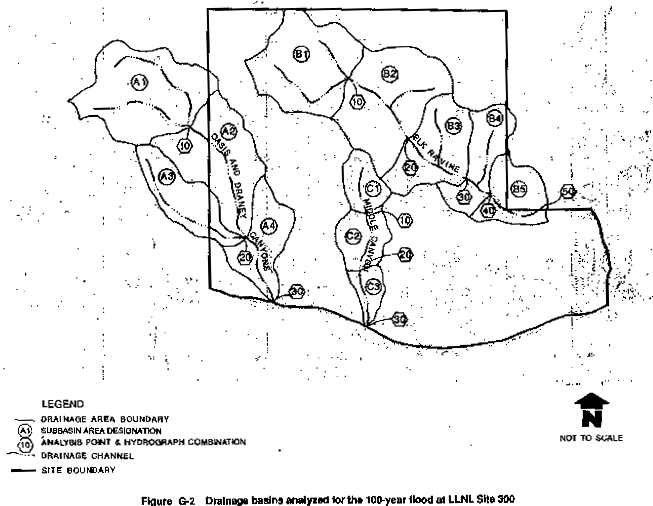
LLNL Site 300 includes several large canyons that drain into Corral Hollow Creek. The Flood Insurance Rate Map of Corral Hollow Creek (U.S. Department of Housing and Urban Development, 1980) was used to characterize the 100-year floodplain for Corral Hollow Creek in the area adjacent to the site. Because onsite analysis of floodplains was unavailable, DOE performed modeling to characterize the 100-year floodplain for the canyons on LLNL Site 300. Rather than model every ravine onsite, however, three canyons were chosen with lengths and depths representative of other onsite drainage. The 100-year flood characteristics were analyzed for two ravines/canyons (Oasis/Draney Canyon or drainage basin A and Elk Ravine or drainage basin B), and a third smaller canyon (Middle Canyon or drainage basin C), all shown in Figure G-2.
The U.S. Army Corps of Engineers Hydrologic Engineering Center Flood Hydrograph Package (HEC-1) computer program was used to model the three representative drainage basins A, B, and C. This model simulates the surface runoff response of a drainage basin to a storm (precipitation event) by representing the basins as an interconnected system of hydrologic and hydraulic components. Each basin comprises smaller basins, or subbasins, and each component models the precipitation-runoff process within drainage subbasins. The modeling results in streamflow hydrographs, which provide peak discharges at locations in the drainage basin (U.S. Army Corps of Engineers, 1981). Model parameters, which represent average conditions within subbasins, include subbasin drainage area, rainfall, precipitation loss factor, unit hydrograph parameter, and flood routing parameter.
The three basins were delineated on a U.S. Geological Survey map of Midway, California, and divided into subbasins (Figure G-2). Table G-1 identifies the basins and subbasins, and their total drainage area.
Rainfall data, in the form of rainfall in inches for any given duration or time, were obtained for East Alameda County (Welch et al., 1966). The data were used to develop incremental rainfall intensities over 6 hours. The incremental amounts were arranged in a sequence that would produce the peak storm event. The resulting time-distributed incremental precipitation represents a precipitation hyetograph. The hyetograph was input into the HEC-1 model according to the precipitation time increment value used in the model.
To calculate precipitation loss, a parameter called a "curve number" is used to estimate the amount of precipitation lost to surface interception, depression storage, and infiltration. This precipitation, therefore, does not contribute to runoff. The Soil Conservation Service has described the relationship among drainage characteristics of soil groups using the curve number, based on soil cover, land use, and antecedent moisture conditions. The HEC-1 model uses this curve number to determine the amount of precipitation lost to infiltration. Soil types are categorized into hydrologic soil groups, and the curve number is weighted according to group (U.S. Department of Agriculture Soil Conservation Service, 1975). The model calculates an average precipitation loss for a computation interval and subtracts it from the precipitation hyetograph. The net precipitation is used to compute an outflow discharge for each subbasin (U.S. Army Corps of Engineers, 1981).
The unit hydrograph computation transforms the subarea precipitation hyetograph to runoff outflow for each subbasin outflow. The Soil Conservation Service Dimensionless Unit Hydrograph method (Viessman et al., 1977) was used to generate a synthetic hydrograph for each subbasin. This method also has a single input parameter, called lag time, which is equivalent to the lag between the center of mass of the rainfall runoff and the peak of the unit hydrograph. The lag time is calculated using the following empirical formula:
L = (hl0.8[S + 1]0.7) / (1,900Y.05)
where,
L = lag time in hours
hl = hydraulic length of watershed
in feet
S = 1,000/CN - 10 (where CN is the retardance factor = 77)
Y
= average watershed land slope in percent
The HEC-1 program uses lag time values to generate the unit hydrographs and subsequent runoff outflows for each subbasin. The parameter values used for the subbasins are listed in Table G-2.
Once outflows for each subbasin are calculated, they must be routed and combined throughout the larger basin area. The Muskingum flood routing technique (Viessman, et al., 1977) was used to simulate flood wave movement through the channel. This method calculates the outflow from a channel reach using the inflow into the reach, the travel time through the reach, and a routing constant. As the hydrograph is moved downstream, the peak is attenuated.
The input parameters to the Muskingum Technique are the travel time, expressed as the K factor, and the routing constant, expressed as x. The K factors for each subarea were calculated by dividing the reach length by the flow velocities. Channel slopes were used to estimate the velocities. The routing constant expresses the relative importance of inflow and outflow in determining storage in the channel. A mean value of 0.2 was used for all subareas. Table G-3 lists the parameters for the reaches in each basin.
The results from the HEC-1 modeling were used to calculate the depth and width of the 100-year floodplain for each basin. An empirical formula, anning's equation (American Iron and Steel Institute, 1971), relates the channel geometry and slope to the amount of flow it can convey. The peak flows were input as the solution to Manning's equation.
Q = 1.49/n x A x R2/3 x S1/2
where,
Q = flow rate (ft3 per second)
n = roughness
coefficient (0.03 for grass-lined waterways)
A = cross-sectional area of
flow
R = hydraulic radius
S = channel slope
A representative channel cross section consisting of a 10-ft bottom width and two horizontal to one vertical (2h:1V) side slopes was used for each ravine/canyon. With depth as a variable, the equation was solved to determine the normal flow depth in addition to the top widths, and velocities could then be calculated.
Table G-1 Drainage Areas in Three Drainage Basins at LLNL Site 300
| Drainage Basin | Subarea | Area (square miles) |
| Oasis and Draney Canyon (A) | A1 | 0.97 |
| A2 | 0.80 | |
| A3 | 0.44 | |
| A4 | 0.44 | |
| Total: | 2.65 | |
| Elk Ravine (B) | B1 | 0.83 |
| B2 | 0.91 | |
| B3 | 0.56 | |
| B4 | 0.38 | |
| B5 | 0.39 | |
| Total: | 3.07 | |
| Middle Canyon (C) | C1 | 0.21 |
| C2 | 0.26 | |
| C3 | 0.15 | |
| Total: | 0.62 |
* See Figure G-2 for locations.
Table G-2 Hydrograph Parameter Values for Subareas in Three Drainage Basins at LLNL Site 300
| Drainage Basin | Subarea | Hydraulic Length (hl) (feet) | Slope (Y) (percent) | Hours (L) |
| Oasis and Draney Canyon | A1 | 8,000 | 10.2 | 0.57 |
| A2 | 8,900 | 9.6 | 0.65 | |
| A3 | 8,000 | 10.0 | 0.58 | |
| A4 | 7,000 | 10.5 | 0.51 | |
| Elk Ravine | B1 | 6,700 | 8.3 | 0.55 |
| B2 | 6,000 | 9.5 | 0.47 | |
| B3 | 5,600 | 11.3 | 0.41 | |
| B4 | 5,500 | 11.1 | 0.41 | |
| B5 | 6,000 | 11.3 | 0.43 | |
| Middle Canyon | C1 | 3,800 | 20.0 | 0.23 |
| C2 | 3,600 | 18.0 | 0.23 | |
| C3 | 4,200 | 15.0 | 0.28 |
Table G-3 Muskingum Routing Parameters for Three Drainage Basins at LLNL Site 300
| Drainage Basin | Reach | Length (feet) | Channel Slope (percent) | Velocity (feet per second) | Travel Time (K factor) |
| Oasis and Draney Canyon (A) | 10 to 20 | 7,000 | 5.30 | 3.5 | 0.56 |
| 20 to 30 | 4,200 | 6.70 | 4.0 | 0.29 | |
| Elk Ravine (B) | 10 to 20 | 4,650 | 1.08 | 1.5 | 0.86 |
| 20 to 30 | 3,950 | 4.05 | 3.1 | 0.27 | |
| 30 to 40 | 1,500 | 2.67 | 2.5 | 0.17 | |
| 40 to 50 | 3,900 | 2.56 | 2.4 | 0.45 | |
| Middle Canyon (C) | 10 to 20 | 2,900 | 7.1 | 4.0 | 0.20 |
| 20 to 30 | 3,250 | 4.0 | 3.0 | 0.30 |
G.2.2 Results
LLNL Livermore Site
The LLNL Livermore site is located at the eastern end of the Livermore valley in southeastern Alameda County, California. The surrounding land is mostly agricultural, residential, and light industrial. The site covers 821 acres that slope to the northwest at a grade of 1.5 percent.
The original course of Arroyo Las Positas was through what is now the LLNL Livermore site. In the 1940s, it was diverted around the site by the U.S. Navy. The arroyo now runs along the eastern boundary of the LLNL Livermore site for approximately 1000 ft, then turns west and flows through the site. Open ditches and storm drains designed for a 10-year storm event drain the site, most running northward and outfalling in the Arroyo Las Positas. A small percentage of land in the southwest corner drains southward to the Arroyo Seco. These arroyos, dry for most of the year, are the two potential sources of onsite flooding. Localized flooding is most likely to occur during the rainy season from October to April.
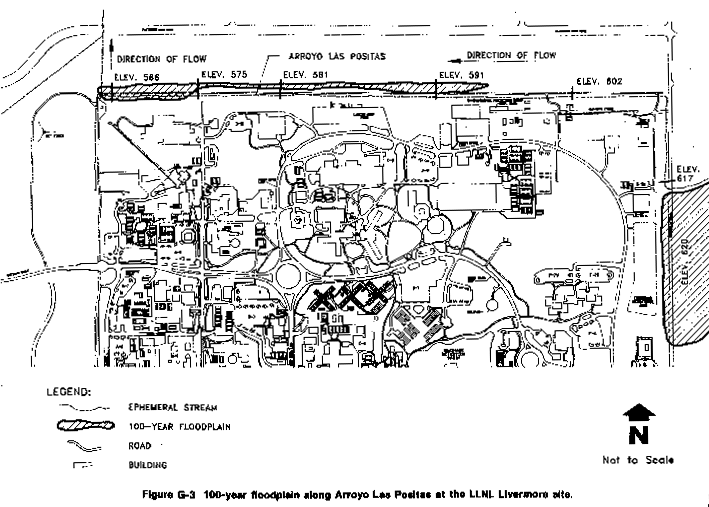
Arroyo Las Positas drains approximately 3300 acres in the northeastern and eastern hills above the LLNL Livermore site. Arroyo Las Positas has a 100-year base flood peak flow of 822 cubic ft per second (Holmes and Narver, Inc. 1985). The 100-year floodplain extends along most of its length as it flows through the site (Figure G-3). Upstream of the eastern border, approximately 1400 ft from Greenville Road, the floodplain width is 100 ft at a flood elevation of 640 ft. At Greenville Road, it spreads to 1500 ft at an elevation of 620 ft and covers the road. This spread is due to the shallow channel depth that cannot contain the 100-year flood; therefore, the flood water spreads until it reaches the elevation of the surrounding topography. The 100-year floodplain along the northern end of the site varies to a width of 120 ft. The elevation is 602 ft at the east end and 566 feet at the west end.
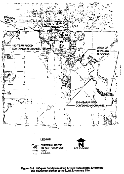
The Arroyo Seco crosses the LLNL Livermore site at the southwestern corner for a distance of about 900 ft. Information from Flood Insurance Rate Map panel 210 indicates there is no floodplain associated with this channel onsite. The 100-year storm event is contained within the channel and poses no flooding threat to the site.
SNL, Livermore
The 413 acre SNL, Livermore site of grassland, is about half developed with buildings and parking lots; the remainder is grasslands. The land slopes from the southeast to northwest at 2.5 percent.
The only surface water feature at SNL, Livermore that may be a flood hazard is the Arroyo Seco, which enters the site on the eastern boundary and exits on the northwestern corner (Figure G-4). An intermittent stream that drains the foothills southeast of SNL, Livermore has a drainage area of 8960 acres. Narrow and shallow where it enters the site, it reaches a depth of 20 ft further downstream.
The Arroyo Seco has a 100-year base flood peak flow of 1220 cubic ft per second (Holmes and Narver, Inc. 1985). The 100-year flood is contained within the channel through most of the site until approximately 3000 ft upstream of East Avenue. The floodplain inundates the overbank area to a maximum width of 70 ft at an elevation of 658 ft. All onsite storm water is collected and channeled to the Arroyo Seco through gutters, culverts, and open ditches. Four bridges, three security fences, and several storm sewer outfalls have the potential to impede the flow of floodwaters through the channel.
LLNL Site 300
LLNL Site 300 is located approximately 15 miles southeast of the LLNL Livermore site in the hills of the Diablo Range. The site occupies approximately 7000 acres and consists of mostly undeveloped land characterized by steep hills and deep ravines. A small percentage is covered with buildings and roads. Corral Hollow Road coincides with the southern boundary.
The 100-year floodplain of Corral Hollow Creek would not impact LLNL Site 300, although parts of Corral Hollow Road would be inundated (Figure G-5). The widths of the 100-year floodplain varied from 13.9 ft in Middle Canyon to 19.6 ft in Oasis and Draney canyons (Table G-4). The depth of flow ranged from 1.0 to 2.4 ft, while peak flow ranged from 91 cu ft/second to 367 cu ft/second. These results indicate that there are no 100-year floodplains onsite; however, due to the steep slopes and high runoff potential, drainage velocities could be excessive during a peak flood event.
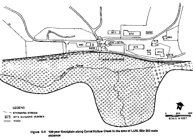
G.2.3 Impacts Proposed Action
Currently, only roadways exist within the boundaries of the 100-year floodplains, of the arroyos on the LLNL Livermore site and SNL, Livermore. At LLNL Site 300, the 100-year floodplain of Corral Hollow Creek extends across Corral Hollow Road to the site. The proposed action, however, would not require construction in, or otherwise alter, the floodplains of Arroyo Las Positas, Arroyo Seco, Corral Hollow Creek, or basins on LLNL Site 300.
Table G-4 100-Year Floodplain Parameters for Three Drainage Basins at LLNL Site 300
| Drainage Basin | Depth of Flow (feet) | Width of Flow (feet) | Velocity (feet per second) | Peak Flow (cubic feet per second) |
| Oasis and Draney Canyon | 2.4 | 19.6 | 10.0 | 355 |
| Elk Ravine | 2.4 | 19.5 | 10.5 | 367 |
| Middle Canyon | 1.0 | 13.9 | 7.9 | 91 |
G.3 WETLANDS EFFECTS
G.3.1 Methods
The wetlands at LLNL and SNL, Livermore were delineated using the Federal anual for Identifying and Delineating Jurisdictional Wetlands (referred to as the federal manual) (Federal Interagency Committee for Wetlands Delineation, 1989). Techniques and criteria in the federal manual emphasize the delineation of the wetland-upland boundary to facilitate the determination of the area covered by wetlands. Although revisions to the federal manual have been proposed, the 1989 version remains in effect until the revisions become final (56 Fed. Reg. 40,446–40,480, 1991).
According to the federal manual, three criteria must be met before an area can be identified as a wetland:
- Hydrophytic vegetation.
- Hydric soils.
- Wetland hydrology.
The wetland indicator status of plants has been determined under the following scheme: species that occur in wetlands 99 percent of the time are called obligate species; those that occur in wetlands 67 to 99 percent of the time are facultative-wet species; those equally likely to occur in wetlands or non-wetlands are facultative plant species; and those that occur 67 to 99 percent of the time in non-wetlands are facultative-upland species. Hydrophytic vegetation is defined as "macrophytic plant life growing in water, soil, or on a substrate that is at least periodically deficient in oxygen as a result of excessive water content." An area has hydrophytic vegetation when, under normal circumstances, more than 50 percent of the vegetation is obligate, facultative-wet, or facultative species. In cases where obligate species (e.g., cattail [Typha sp.]) compose the dominant portion of the plant community, "the area can be considered wetland without detailed examination of soils and hydrology, provided significant hydrologic modifications are not evident" (Federal Interagency Committee for Wetlands Delineation, 1989).
"Hydric soils are defined as soils that are saturated, flooded, or ponded long enough (7 days or longer) during the growing season to develop anaerobic conditions in the upper part" (Federal Interagency Committee for Wetlands Delineation, 1989). The two most common soil features that reflect wetness in mineral soils are gleying (contains mostly gray soils) and mottling. Prolonged saturation of mineral soil causes it to become gleyed throughout; this soil feature is especially useful for delineating wetland boundaries when standing water and/or saturated soil conditions are not present and/or when obligate plant species are not in evidence.
An area is said to have wetland hydrology when it is permanently or periodically inundated (at least 7 days) during the growing season. Hydrological conditions that form wetlands can be found in such places as floodplains along rivers and lakes, estuaries, isolated depressions surrounded by uplands, surface water drainages, and at springs and seeps. "Frequency and duration of inundation or soil saturation are important in separating wetlands from non-wetlands" (Federal Interagency Committee for Wetlands Delineation, 1989).
The observation of wetland hydrological conditions, such as surface water or saturated soils, may be obvious at certain times of year (e.g., early spring) or in certain wetlands (e.g., cattail marsh or spring-fed wetlands), and not so obvious at other times, especially at the wetland-upland boundary. "Consequently, the emphasis on delineating wetland boundaries should be placed on hydrophytic vegetation and hydric soils in the absence of significant hydrologic modification, although wetland hydrology should always be considered" (Federal Interagency Committee for Wetlands Delineation, 1989).
The California Department of Fish and Game administers the state wetlands program consistent with California Fish and Game Commission Policy "to provide for the protection, preservation, restoration, enhancement and expansion of wetland habitat in California." Furthermore, the commission's policy calls for "no net loss" of either wetland habitat values or acreage (California Fish and Game Commission, 1987).
The California Department of Fish and Game also adheres to the U.S. Fish and Wildlife Service wetlands definition and classification systems as presented by Cowardin et al. (1979). This definition includes the three factors listed in the federal manual (Federal Interagency Committee for Wetlands Delineation, 1989). The major difference is that the federal manual requires all three factors be present for an area to be considered a wetland while the state definition requires only one factor (Rollins, 1987a, 1987b). This means that the state may consider areas wetlands (e.g., nonvegetated mud flats) that would not be defined as wetland by the federal manual.
DOE and UC mapped wetlands during ground reconnaissance of the LLNL Livermore site and LLNL Site 300. Wetlands at SNL, Livermore had previously been mapped during a recent survey (Environmental Science Associates, 1990). Wetlands at all three sites were plotted on aerial photographs or detailed site maps. The dominant plant species were noted along with hydrological conditions. The size of the wetlands was determined from measurements made in the field and wetlands were plotted on field maps. Data collected for each wetland were recorded on the field maps and in a field notebook. The soil was inspected for evidence of inundation (i.e., gleying) or saturated soil beneath the surface. The Muncell Soil Color Charts (Kollmorgen Corporation, 1988) were consulted to determine soil chroma (indicates soil color strength or purity): chromas of two or less are often indicators of hydric soils.
G.3.2 Results
Wetlands observed at the three sites are consistent with DOE definition of wetlands (10 C.F.R. part 1022.4(v), 1979), with the criteria in the federal manual (Federal Interagency Committee for Wetlands Delineation, 1989), and with the California Department of Fish and Game definition (Cowardin et al., 1979) of wetlands. No areas were observed that would be considered wetlands based solely on the state definition.
LLNL Livermore Site
Wetlands at the LLNL Livermore site are limited to three small areas along Arroyo Las Positas (Figure G-6) found at and downstream from culverts that channel runoff from the surrounding areas. Two areas, totaling 0.3 acre, were dominated by saltgrass (Distichlis spicata); a species of Carex was also common. Other species observed were willow (Salix sp.), cattail, curly dock (Rumex crispis), ryegrass (Elymus sp.), and Hooker's evening primrose (Oenothera hookeri ). One saltgrass wetland had standing and flowing water with other areas of very wet soil. The other wetland was drier, with sandy soil. The third wetland was a small area (0.06 acre) at a culvert near Building 194. Cattail was the dominant species with other species such as Carex sp. and saltgrass also commonly observed. Both standing and flowing water were in this area and the soil was sandy (observations were made in May 1991).
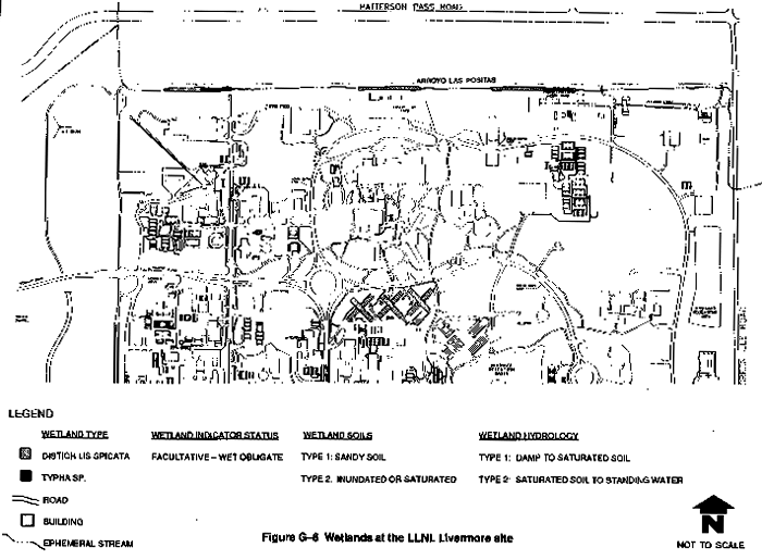
SNL, Livermore
Wetland habitat at SNL, Livermore consists of a 1.44 acres in two areas at the western end of the Arroyo Seco (Figure G-7) (Environmental Science Associates, 1990). This wetland consists of 1.32 acres of a remnant wooded riparian area with valley oak (Quercus lobata) and sycamore (Platanus racemosa) the dominant tree species. Red willow (Salix lasiandra), mule fat (Baccharis viminea), seaside heliotrope (Heliotropium curassavicum), Curly Dock (Rumex crispus), and tree tobacco (Nicotiana glauca) were common in the understory. The groundcover is dominated by patches of cattail and rush (Juncus sp.). The remainder of the wetland (0.12 acre) is an alkali marsh with such species as alkali ryegrass (Elymus triticoides) and saltgrass.
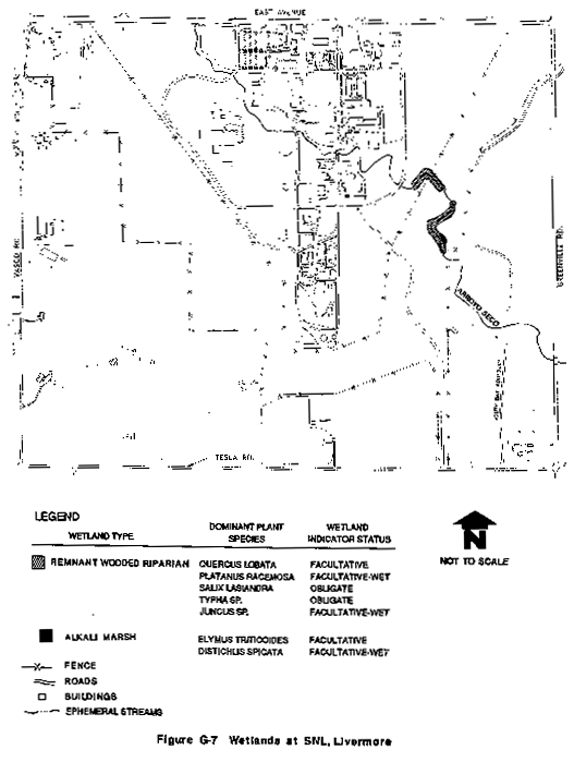
LLNL Site 300
Wetlands observed were small, with many occurring in a series of isolated wetlands in deep canyons. Each series is termed a wetlands complex. The wetlands were categorized according to source of water as follows:
- Wetlands arising from natural springs.
- Artificial wetlands created from runoff from LLNL Site 300 buildings. The runoff from the LLNL Site 300 buildings is permitted through a water quality permit from the State of California.
- The vernal pool, which is a wetland created from standing water.
The spring-fed and artificial wetlands were mapped on the basis of dominant vegetation. Sections of these wetlands were dominated by cattail, alkali ryegrass, or rush (Juncus oxymeris). Those wetlands dominated by cattail, rush, and alkali ryegrass are referred to as herbaceous wetlands. A total of 16 wetlands or wetlands complexes were identified at LLNL Site 300 (Figure G-8) and are discussed in terms of both the source of water and the dominant plant species. The wetlands locations summarized in Figure G-8 are mapped separately and are shown on Figure G-9 through Figure G-23
Many of the natural wetlands arise from springs at the bottom of deep canyons in the southern half of the site, except for a vernal pool in the northwestern section of the site. These springs occur where water-bearing sandstone units crop out in the canyon or valley bottoms. The wetlands that have developed at these springs are confined by the steep-sided canyon walls; they range in width from 5 to 30 ft and most are 10 to 20 ft wide. Most are relatively short, 100 to 600 ft long; the longest is in Oasis Canyon and is approximately 2800 ft long (Figure G-9).
The plant species observed in these wetlands grew in relatively homogenous stands. Cattail was dominant in areas of flowing or saturated soil where it formed dense stands, typically at the spring and downstream. Species such as Juncus oxymeris, seep-spring monkey-flower (Mimulus guittatus), whitestem hedge nettle (Stachys albens) and, in some places, white watercress (Rorippa nasturtium) were frequently observed in areas of flowing water. In limited areas, J. oxymeris was dominant in standing water or saturated soil. Proceeding to areas of decreasing soil moisture, alkali ryegrass became the dominant species, ultimately giving way to the upland plant species. Alkali ryegrass grew in homogenous stands, which stood out sharply from the surrounding brown upland grasses because of their conspicuous green color. It was observed in dense stands in very moist soil and became sparse as the soil became drier. Large isolated cottonwood (Populus fremontii) were often present in the spring-fed deep canyon wetlands. Plant species observed at LLNL Site 300 wetlands are listed in Table G-5. These species were either recorded during detailed vegetation studies in 1986 (Taylor and Davilla, 1986) or observed during the 1991 wetlands surveys.
The wetlands dominated by herbaceous species were mapped according to the dominant plant species. Wetlands dominated by cattail covered 3.54 acres; those dominated by alkali ryegrass covered 2.04 acres; those dominated by Juncus oxymeris covered 0.22 acre; and those dominated by willow (Salix laevigata) covered 0.64 acre. The vernal pool covered 0.32 acre. The total area of all wetlands at LLNL Site 300 is 6.76 acres (Table G-6). Many of the natural wetlands at LLNL Site 300 are essentially unaltered by human activities. This is particularly true for the wetlands in the larger canyons in the southern portion of the site (Oasis, Draney, Drop Tower, Middle, and Long canyons) and the wooded riparian wetland along Elk Ravine. Grazing or other human-induced land uses have not occurred in these wetlands since the early 1950s. In addition, these wetlands are remote from human activities at LLNL Site 300. The cover and available water in these spring-fed wetlands are important resources for the resident wildlife. They provide habitat for amphibians such as the California slender salamander (Batrachoseps attenuatus), western toad (Bufo boreas), and Pacific tree frog (Hyla regilla), and for reptiles such as the northern alligator lizard (Gerrhonotus coeruleus).
Vegetation at some of these springs provides nesting habitat for the red-winged blackbird (Agelaius phoeniceus). The springs are important for species that require daily water such as the lazuli bunting (Passerina amoena), California quail (Callipepla californica), cliff swallow (Hirundo pyrrhanota), and mourning dove (Zenaida macroura). The great horned owl (Bubo virginianus) was often observed in trees in these riparian zones. Aquatic species of birds are limited to a pair of mallards (Anas platyrhynchos) and one green-backed heron (Butorides striatus) observed at the LLNL Site 300 sewage lagoon.
No aquatic mammal species were observed; however, the small wetlands and associated available water are important to such species as the striped skunk (Mephitis mephitis) and black-tailed deer (Odocoileus hemionus). Various species of bats are known to forage over the sewage lagoon.
The remaining natural wetlands near Buildings 827 and 832 and at the lower spring, firing range wetland, and Corral Draw springs and the artificial wetlands (Buildings 827, 865, 801, and 851) are closer to human activity zones and are less important for wildlife habitat. In addition, some of these wetlands (especially Buildings 827 and 832 natural wetlands) are clogged with an accumulation of dead Russian thistle (Solsola kali ), which had blown in from surrounding areas, further reducing their value to wildlife.
The only wetland not created by springs or by runoff from buildings is a vernal pool in the northwestern part of LLNL Site 300 (Figure G-8). This pool is oval-shaped and bounded by gently sloping hillsides on the northern and southern sides, a man-made mound on the eastern side, and a gently sloping valley to the west (Figure G-19). "Generally speaking, a vernal pool or hogwallow is a small, hardpan-floored depression in a valley grassland mosaic that fills with water during the winter. As it dries up in the spring, various annual plant species flower, often in conspicuous concentric rings of showy colors" (Holland and Jain, 1977).
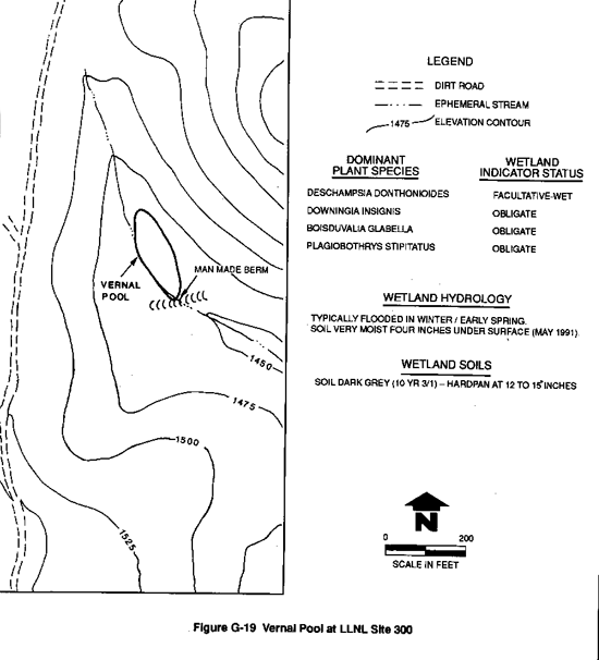
The vernal pool at LLNL Site 300 consists of a center area that is bare of vegetation (as observed in May 1991) and concentric circles of different plant species until upland grasses became dominant. The species composition and growth pattern of plants (typically low-growing plants) in the vernal pool are distinct from the surrounding grasslands. Some plant species observed in the vernal pool (Table G-5) are typical of such pools (Holland and Jain, 1977). The soil in the vernal pool is dark gray, and moist at 4 to 6 inches. A hardpan occurs at a depth of 12 to 15 inches.
Table G-5 Plant Species Observed in Three Wetland Plant Community Types at LLNL Site 300
| Species and Common Name | Wetland Type | Wetland Indicator Statusb | ||
| Herbaceousa Wetlands | Wooded Riparian Wetlands | Vernal Pool | ||
| Native Grasses and Grass-like Species | ||||
| Deschampsia donthonioides Annual hairgrass | X | FACW | ||
| Elymus triticoides Alkali ryegrass | X | FAC | ||
| Elymus glaucus Ryegrass | X | FACU | ||
| Distichlis spicata Saltgrass | X | FACW | ||
| Juncus oxymeris Rush | X | FACW | ||
| Typha latifolia Cattail | X | X | OBL | |
| Poa scabrella Pine bluegrass | X | --- | ||
| Introduced Grasses | ||||
| Bromus diandrus Brome grass | X | --- | ||
| Bromus mollis Soft cress | X | FAC | ||
| Bromus rubens Foxtail | X | --- | ||
| Avena barbata Slender oat | X | --- | ||
| Lolium perenne Italian ryegrass | X | FAC* | ||
| Polypogon interruptus Ditch polypogon | X | OBL | ||
| Polypogon monspeliensis Rabbitfoot grass | X | FACW | ||
| Vulpia myuros Fescue | X | FACU* | ||
| Native Forbs | ||||
| Boisduvalia glabella Smooth spike-primrose | X | OBL | ||
| Downingia insignis Cupped downingia | X | OBL | ||
| Eremocarpus setigerus Turkey mullein | X | --- | ||
| Grindelia camporum Great valley gumplant | X | FACU | ||
| Mimulus guttatus Seep-spring onkey-flower | X | X | OBL | |
| Plagiobothrys stipitatus | X | OBL | ||
| Rorippa nasturtium White watercress | X | X | OBL | |
| Sanicula bipinnatus Poison sanicle | X | --- | ||
| Scrophularia californica California figwort | X | FAC | ||
| Stachys albens Whitestem hedge nettle | X | OBL | ||
| Introduced Forbs | ||||
| Brassica geniculata Short-pod mustard | X | --- | ||
| Carduus pycnocephalus Italian thistle | X | --- | ||
| Centaurea melitensis Tocalote | X | --- | ||
| Cerastium glomeratum Chickweed | X | --- | ||
| Cirsium vulgare Bull thistle | X | FACU | ||
| Galium aparine Bedstraw | X | FACU | ||
| Marrubium vulgare Horehound | X | FAC | ||
| Rumex crispus Curly dock | X | FACW | ||
| Sonchus asper Sow thistle | X | FAC | ||
| Sonchus oleraceus Common sow thistle | X | --- | ||
| Urtica dioica Stinging nettle | X | X | FACW | |
| Woody Species | ||||
| Populus fremontii Cottonwood | X | FACW | ||
| Salix laevigata Smooth willow | X | FACW to OBLc | ||
| Sambucus mexicana Elderberry | X | FAC | ||
aIncludes those wetlands dominated by cattail,
rush, and alkali ryegrass.
b OBL = obligate wetland species; FACW = usually
occurs in wetlands; FAC = equally as likely to occur in wetland or nonwetland;
FACU = usually occurs in nonwetlands; --- = not on list and assumed to be
nonwetland species; * = based on limited ecological information.
cSpecies not on U.S. Fish and Wildlife Service
wetland indicator status list, but all willow are OBL or FACW. Source: Taylor
and Davilla, 1986; U.S. Fish and Wildlife Service, 1988.
Table G-6 Acres of Wetlands by Plant Community Type at LLNL Site 300
| Location* | Wetland Type | Total | ||||
| Typha latifolia | Elymus triticoides | Juncus oxymearis | Wooded riparian | Vernal pool | ||
| Oasis Canyon | 0.60 | 0.10 | 0.12 | 0.00 | 0.00 | 0.82 |
| Draney Canyon | 0.07 | 0.04 | 0.00 | 0.00 | 0.00 | 0.11 |
| Drop Tower Canyon | 0.19 | 0.29 | 0.03 | 0.00 | 0.00 | 0.51 |
| Lower Spring | 0.05 | 0.00 | 0.01 | 0.00 | 0.00 | 0.06 |
| Firing Range Spring | 0.00 | 0.08 | 0.03 | 0.00 | 0.00 | 0.11 |
| Middle Canyon | 0.03 | 0.19 | 0.03 | 0.00 | 0.00 | 0.25 |
| Long Canyon | 0.04 | 0.02 | 0.00 | 0.00 | 0.00 | 0.06 |
| Building 827: Artificial | 0.25 | 0.00 | 0.00 | 0.00 | 0.00 | 0.25 |
| Natural | 0.24 | 0.12 | 0.00 | 0.00 | 0.00 | 0.36 |
| Building 832 Canyon | 0.48 | 0.00 | 0.00 | 0.00 | 0.00 | 0.48 |
| Corral Draw Springs | 0.04 | 0.20 | 0.00 | 0.00 | 0.00 | 0.24 |
| Vernal Pool | 0.00 | 0.00 | 0.00 | 0.00 | 0.32 | 0.32 |
| Building 865: Artificial | 0.41 | 0.82 | 0.00 | 0.00 | 0.00 | 1.23 |
| Building 801: Artificial | 0.14 | 0.00 | 0.00 | 0.00 | 0.00 | 0.14 |
| Elk Ravine | 0.92 | 0.00 | 0.00 | 0.64 | 0.00 | 1.56 |
| Building 851: Artificial | 0.08 | 0.18 | 0.00 | 0.00 | 0.00 | 0.26 |
| Total: | 3.54 | 2.04 | 0.22 | 0.64 | 0.32 | 6.76 |
* See Figure G-8 for locations.
G.3.3 Impacts Proposed Action
LLNL Livermore Site and SNL, Livermore
The proposed action is described in Section 3 and Appendix A. Wetlands at the LLNL Livermore site and SNL, Livermore are located away from any planned development and the proposed projects would not impact the wetlands at these two sites.
LLNL Site 300
Planned proposed action construction activities that would not impact wetlands at LLNL Site 300 include the replacement of a fire station and the construction of the Explosives Waste Storage Facility, Explosives Waste Treatment Facility, Contained Firing Facility, and Cheap Access to Orbit Facility. These activities would not take place at or near any onsite wetlands; more information regarding these projects appears in section 3.1.2 of the EIS/EIR and in Appendix A.
A proposed action project that would impact wetlands has to do with the elimination of surface water runoff from some of the cooling towers at LLNL Site 300. Surface water runoff from the cooling towers have created wetlands at and near Buildings 801, 827, 851, and 865. Surface water runoff may be eliminated from many of the cooling towers, including those at Buildings 827 and 851, to comply with the State of California Regional Water Quality Control Board requirements. Implementation of this project would result in the disappearance of approximately 0.5 acre of artificial wetlands at these two buildings. At this time, it is expected that this impact would occur within 2 years. Within 5 years, the artificial wetlands at Buildings 801 and 865 may be reduced due to an estimated 75 percent decrease in the discharge of water.
The U.S. Army Corps of Engineers currently regulates some artificial wetlands, however, the artificial wetlands at LLNL Site 300 are not regulated (Coe, 1991). The artificial wetlands at Site 300 fall under state jurisdiction and under the states no net loss requirement. Section G.5 discusses potential mitigation for the loss of 0.5 acre of wetland.
Direct or indirect negative impacts from future projects should be avoided at natural wetlands identified as sensitive areas at LLNL Site 300. This is especially true for the vernal pool, a unique wetland resource that should be protected from alterations of any kind.
G.4 ALTERNATIVES
No Action Alternative
The no action alternative involves continued operations, including authorized facilities and funded projects such as internal upgrades to buildings, the site revitalization plan, and the on-going ground water restoration project (see section 3.2.1).
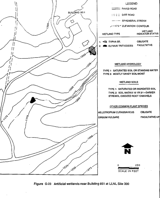
The diagnostic upgrades at firing bunkers 801 and 851 would not impact the 100-year floodplain or wetlands. The artificial wetlands at Building 801 are the result of water draining from this site; they begin about 600 ft south down the access road at the corner of Linac Road. Upgrading this building would not result in a direct impact to these wetlands. In addition, the water-use patterns at this site would likely remain the same resulting in no impact to the artificial wetlands.
The artificial wetlands at Bunker 851 occur on a steep slope at the east end of the building area and approximately 500 ft down the canyon to the east (Figure G-23). The revitalization program at Building 851 involves upgrading the computer system; there were no impacts to the artificial wetlands at this site or the 100-year floodplain.
Road upgrades are part of the site revitalization plan and would not impact the artificial wetlands that are formed by runoff from Building 865. Wetlands occur along a section of Linac Road between Building 802 and Do-all Road. Linac Road will be widened by 3 ft on either side to provide shoulders. The wetlands in this area are far enough away from the road (Figure G-20) and would not be impacted. These upgrades also would not impact the 100-year floodplain.
Analysis of ground water at LLNL Site 300 indicates that there is ground water contamination below Buildings 833, 834, 850, landfill Pit 6, the high explosives process area, and the general services area (Bryn, Landgraf, and Booth, 1990; Crow and Lamarre, 1990; Ferry, Lamarre, and Landgraf, 1990; Taffet, Copland, and Ferry, 1991; Taffet and Oberdorfer, 1991; Webster-Scholten et al., 1991). These studies indicate that the contamination is restricted to the ground water and has not come to the surface at any of the spring-fed wetlands onsite.
A plume from the General Services Area has contaminated the alluvia/shallow bedrock aquifer under a segment of Corral Hollow Creek offsite (Ferry, Lamarre, and Landgraf, 1990). There is no indication that springs along Corral Hollow Creek have been contaminated by this plume.
The proposed remedial action for the central General Services Area and the current remedial action at the eastern General Services Areas is to extract and treat the contaminated ground water and then discharge the treated ground water into Corral Hollow Creek. In the vicinity of the General Services Area, the creek is bordered by wooded riparian vegetation, with cottonwood the dominant canopy tree species. Mulefat and willow occur in the understory. One spring dominated by rush (Juncus sp.) occurs approximately 700 ft downstream from the eastern General Services Area (Ferry, Lamarre, and Landgraf, 1990). The wooded riparian vegetation is well developed in some areas and sparse in others.
The discharge of treated ground water the central and eastern General Services Areas and other ground water remedial action projects is expected to result in five different release points into Corral Hollow Creek. These release points are well over 200 ft apart, and the potential exists for perennial flow for at least a short distance downstream from each discharge point. For example, the predicted length of flowing water from the General Services Area discharge point was 100 ft (Ferry, Lamarre, and Landgraf, 1990). Treated ground water from the eastern General Services Area has been released into Corral Hollow Creek since June 1991, and the area of wet ground and shallow surface water is approximately 100 ft as predicted. Flows from these discharge points would result in an increase in wetland vegetation with such species as cattail, rush, and alkali ryegrass becoming established. Also, an increase in cottonwood and willow can be expected. This increase in riparian wetland vegetation would benefit wildlife. One possible negative impact would be the development of an extensive area of perennial flow, which could promote fish migration up the creek and result in a reduction of sensitive amphibian species such as the tiger salamander and red-legged frog. However, the relatively low flows at the discharge points (60 to 100 gal per minute at each point), the high porosity of the Corral Hollow Creek bed, and the low rainfall/high evapotransporation climate all join to make this outcome unlikely.
Modification of Operations Alternative
The modification of operations alternative would affect existing and near-term proposed projects to reduce adverse impacts. Based on the modifications discussed in section 3.2.1, natural wetlands and the 100-year floodplains would not be impacted by implementation of this alternative. The artificial wetlands at Buildings 801, 827, 851, and 865, however, may be eliminated or reduced by this alternative. If this were to occur, the impact of this alternative would be similar to the impact of the proposed action.
Shutdown and Decommissioning Alternative
Implementation of the shutdown and decommissioning alternative would remove any potential impact from LLNL activities (once shutdown and decommissioning activities were complete) to the 100-year floodplain at any of the sites or to the wetlands at the LLNL Livermore site and SNL, Livermore. The artificial wetlands at LLNL Site 300 would eventually disappear as operations at the site were phased out. This would result in the loss of 1.9 acres of artificial wetlands. In addition, if grazing were allowed on LLNL Site 300 after shutdown, degradation of the natural wetlands could be expected. This is especially true for the small unaltered spring-fed wetlands in the deep canyons onsite. As stated by Katibah, Drummer, and Nedeff, (1981), "Heavy grazing in riparian zones would eventually lead to the total destruction of the riparian vegetation within them (wetlands). Forage is then lost, shade is gone, and water, now exposed to the sun, evaporates more rapidly." As indicated in section G.3.2, many of the natural wetlands at LLNL Site 300 are unaltered by human activities. Katibah, Drummer, and Nedeff, (1981) determined that unaltered wetlands form a very small percentage (2.5 percent, or 5000 to 7500 acres) of the remaining wetlands in the Central Valley. The impact of grazing would be the elimination or degradation of unaltered natural wetlands (estimated at 3.9 acres) onsite and the loss of these important areas to resident wildlife.
G.5 MITIGATION
The proposed action would result in the elimination of the 0.5 acre of artificial wetlands at LLNL Site 300. These wetlands are not regulated by the U.S. Army Corp of Engineers, so a permit from this agency would not be required to eliminate the wetlands (Coe, 1991). The State of California, however, has a policy of no net loss of wetlands (Rollins, 1987a, 1987b) that applies to all wetlands including artificial wetlands (Bradovitch, 1991). Mitigation for the loss of these wetlands would be determined in consultation with the California Department of Fish and Game.
The ground water restoration project may provide mitigation for loss of wetlands through the creation of wetland vegetation in Corral Hollow Creek. It is difficult to predict the area of wetlands that would be created in Corral Hollow Creek. Assuming five discharge points along Corral Hollow Creek, then five distinct areas of saturated soil totalling 600-ft long by 35-ft wide would result in almost 0.5 acre of wetland vegetation. This scenario is entirely possible given the nature of the ground water restoration project.
|
NEWSLETTER
|
| Join the GlobalSecurity.org mailing list |
|
|
|