


4.11 WATER
This section provides an overview of surface and ground water at the LLNL Livermore site, LLNL Site 300, and SNL, Livermore. Additionally, this section describes water use and flood plains at these sites. A discussion of existing contamination in the ground water at and adjacent to the sites is included in section 4.17.
4.11.1 Surface Water
LLNL Livermore Site and SNL, Livermore
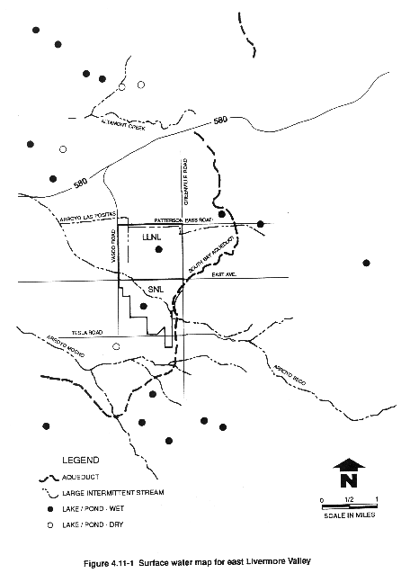
Surface drainage and natural surface infiltration at the LLNL Livermore site and SNL, Livermore are generally good, but drainage decreases locally with increasing clay content in surface soils (U.S. Department of Agriculture Soil Conservation Service, 1966, 1990). While they are distinct operations managed and operated by different contractors, for purposes of this document the LLNL Livermore site and SNL, Livermore are addressed together because of their proximity. Only intermittent streams flow into the eastern Livermore Valley from the surrounding uplands and low hills, where they merge on the valley floor. Surface flow may occur intermittently from October to April, during the valley's wet season. The four major intermittent streams that drain into the eastern Livermore Valley are Arroyo Mocho, Arroyo Seco, Arroyo Las Positas, and Altamont Creek (Figure 4.11-1). Recharge to the sediments underlying the Livermore Valley is primarily from the arroyos that originate in the eastern foothills and flow across the valley. When surface flow occurs in these channels, water infiltrates into the underlying alluvium and eventually percolates to the aquifers within the Valley (Rogers, 1982; Stone et al., 1982).
The headwaters of the Arroyo Seco drainage are in the hills southeast of the LLNL Livermore site and SNL, Livermore. Arroyo Seco has a drainage length of approximately 12 miles and has a watershed area of approximately 8960 acres upstream of SNL, Livermore. The channel is well defined in the section that passes directly through the LLNL Livermore site and SNL, Livermore, and it is dry for at least 6 months of the year. In fact, during dry years, it may flow only 10–15 days/year in the LLNL Livermore site vicinity.
A field survey of watercourses and ponds was conducted for this EIS/EIR in April and May 1991. Arroyo Seco was dry during the survey, except where the channel enters the perimeter area of SNL, Livermore to the southeast. In that area there were several shallow pools with an assortment of established hydrophytic vegetation.
Arroyo Las Positas drains from the hills directly east of the LLNL Livermore site with a watershed area of approximately 3300 acres. The channel is not well defined and usually carries only storm water runoff. This channel enters the LLNL Livermore site from the east, is diverted along a storm ditch around the northern edge of the site, and exits the site at the northwest corner. A pool of standing water with established hydrophytic vegetation was found in this ditch before it exited the site.
Nearly all surface water runoff at the LLNL Livermore site is discharged into Arroyo Las Positas; only surface runoff along the southern boundary and some storm drains in the southwest corner of the LLNL Livermore site drain into Arroyo Seco. All surface runoff from SNL, Livermore is discharged into Arroyo Seco. All of the abovementioned intermittent stream channels join west of the two sites. Regional drainage is through the southwestern part of the Livermore Valley into the San Francisco Bay through Alameda Creek.
Other natural and artificial bodies of water present in the eastern Livermore Valley are shown in Figure 4.11-1. There are more than 30 assorted ponds located in and around the eastern Livermore Valley, 20 of which are located within a 5-mile radius of the LLNL Livermore site. The majority of the small ponds are used for private water storage for livestock watering; some have other uses, such as ornamental. The Patterson Reservoir is located approximately 0.8 mile to the northeast of the LLNL Livermore site. This reservoir covers an area of 3.23 acres and contains a volume of about 100 acre-feet. The South Bay Aqueduct is an open canal that circles the Livermore Valley and delivers water to the south San Francisco Bay Area. Several ponds in the area were dry or nearly dry at the time of the April–May 1991 field survey because of recent drought conditions. The pond situated on the LLNL Livermore site called the Drainage Retention Basin receives local runoff. This basin was dry at the time of the survey. During extremely wet times this basin can overflow through culverts into the LLNL storm drains to the diverted course of Arroyo Las Positas. A second basin constructed by LLNL to recharge treated ground water is located in the west perimeter area at SNL, Livermore. This basin was dry during the survey period.
LLNL routinely performs surveillance monitoring of waters for the LLNL Livermore site and surrounding regions of the Livermore Valley (LLNL, 1990d, 1991f). The waters monitored in the Livermore Valley include lakes and aqueducts, tap water, storm water runoff, and water supply wells. The samples are collected on a quarterly basis and are analyzed for gross alpha and beta radiation, tritium, and nonradioactive pollutants, including solvents, metals, and pesticides (LLNL, 1990d, 1991f). Water samples are collected from five surface water sources, an onsite swimming pool, and four domestic water supplies, one onsite at LLNL, and four offsite. In addition to the historical rainfall collection location for the LLNL Livermore site, 16 new locations have been established for a special assessment of tritium in rain and storm water. Rain samples are collected after each rainstorm and storm water samples are collected during the storm. Tritium released into the atmosphere from the LLNL Livermore site and SNL, Livermore may become entrained in raindrops that pass through the plume. The incident rainfall may accumulate and remain in standing pools of water at the ground surface. The rainfall that accumulates in pools represents an additional potential source of exposure due to inhalation and absorption through the skin for several days following a rain before the water evaporates or percolates into the ground. Currently, the storm water runoff monitoring program includes sampling of nine locations during the period of active surface water flow that follows the first major storm event of the rain season. Acetone and other organics have been found sporadically at various locations.
Gross alpha and beta activities in these surface and domestic water samples collected in 1990 were below EPA and DHS maximum contaminant levels. Tritium activities exceeded the maximum contaminant level for drinking water (20,000 pCi/L) in storm water runoff at the LLNL Livermore site. The range of tritium concentrations in storm water runoff detected at the LLNL Livermore site was 130 pCi/L to 57,000 pCi/L. Storm water is not drinking water and the maximum contaminant levels are used for comparison and trend analysis only. These concentrations may also be compared with the DOE discharge limit for discharges to sanitary sewers, which is 1×10⁻²mCi/mL.
The highest tritium activity concentration detected for surface water bodies was 1090 pCi/L in the onsite swimming pool (LLNL, 1991f). The estimated annual (effective) dose assuming that a person consumed 2 L of water per day containing this tritium concentration would be 0.056 mrem (LLNL, 1991f).
An evaluation of the rain to surface water pool exposure pathway was conducted to determine the relative contribution to dose. Assuming exposure for 10 days a year (24 hours per day) to standing pools of rainwater with a concentration of 3.2×10³ pCi/L (maximum observed average concentration in rainwater at the site boundary during 1990), and a water intake rate through inhalation and absorption through the skin of 220 mL/day (NCRP, 1979), the resulting dose is estimated to be 4×10⁻⁷rem (0.0004 mrem)/year, compared to the annual dose limit of 0.01rem (10 mrem) for atmospheric releases. The calculation of radiation doses for tritium releases into the atmosphere using AIRDOS-PC, and presented in Section 4.10, assumes that all water inhaled or absorbed through the skin is in equilibrium with the tritiated water vapor in the air. Thus the doses presented here are a subset of the AIRDOS-PC calculations and are not additive.
None of the water production wells monitored contained tritium concentrations that were above the maximum contaminant level, and all were near background levels. Nonradioactive contaminants were generally not present at detectable levels in storm runoff. Acetone was detected at four locations with the highest concentration being 16 mg/L. Solvents were detected in trace quantities. Both solvents and acetone were below the maximum contaminant levels. Metals were not detected above normal background levels expected for water that has been in contact with soil (LLNL, 1991f).
LLNL Site 300
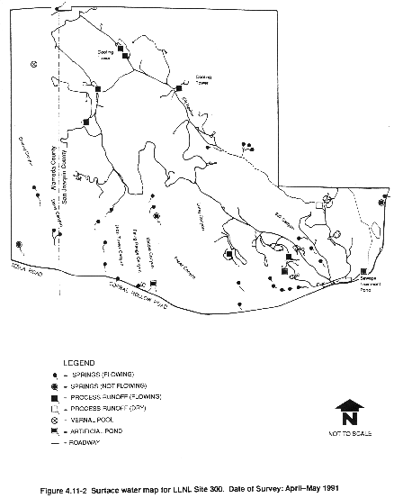
An inventory of surface waters and wetlands at LLNL Site 300 was made in late April to early May 1991 and is presented on Figure 4.11-2. A discussion of wetlands is presented in section 4.9.4. Figure 4.11-2 shows all springs and pools at LLNL Site 300. There are no perennial streams at or near LLNL Site 300. The canyons that dissect the hills and ridges at LLNL Site 300 drain into intermittent streams. The majority of the intermittent streams onsite drain to the south to Corral Hollow Creek, also intermittent, which runs along the southern boundary of LLNL Site 300 toward the east into the San Joaquin Valley. Some of the canyons in the northeast section of the site drain to the north and east toward Tracy in the San Joaquin Valley. During the survey, only Corral Hollow Creek contained a small flow. A minor amount of drainage in the northwest portions of LLNL Site 300 is to the Livermore Valley.
Naturally occurring springs show both the presence of flowing water or wet soils where the water table at that point is close to the surface, and the presence of distinct hydrophytic vegetation (cattails, willow) described in section 4.9. There are 24 flowing springs onsite with a single-flowing spring located just offsite along the north fence on the Alameda/ San Joaquin County line. Another producing spring is located on adjacent State of California property along the south border of LLNL Site 300. This spring is located east of the pistol range and has been excavated to allow a year-long artificial pond to accumulate. The flow from this spring originates from an artesian well which is allowed to discharge into the pond. There are also at least three nonflowing springs onsite with resident hydrophytic vegetation and wet soils.
A single vernal pool was identified in the northwest corner of the site. This pool had both distinctive vegetation and wet soils just below the surface, but was dry. Many other dry pools were noted, but vegetation and dry soils distinguished them as ephemeral pools.
Several areas of surface water discharge were observed onsite near cooling towers or other process runoff areas (Figure 4.11-2). These artificial runoff areas have the same characteristics as natural springs because they contain running water and support hydrophytic vegetation. A single surface source was noted originating from the Building 834 complex at the time of the survey; here, the vegetation was present but the soils were all dry. The General Services Area at LLNL Site 300 has one sewage treatment pond and an overflow basin located on the southeast border of the site.
The Environmental Monitoring Group conducts routine monitoring for surface and domestic water in the vicinity of LLNL Site 300. Surface water samples are collected quarterly from Corral Hollow Creek, a rainfall collection location near Bunker 812, in the center of LLNL Site 300, and from a number of water production wells (both active and inactive). Surface water samples are collected and analyzed for gross alpha, gross beta, and tritium activity. Water supply wells are sampled quarterly for gross alpha, gross beta, tritium activity, volatile organic compounds, and metals (beryllium, chromium, copper, and lead).
As discussed in section 4.17, effluent from ground water treatment systems and sewer and cooling tower discharges are also monitored periodically according to NPDES requirements.
Gross alpha and beta activities in the surface water samples collected in 1990 were below EPA and DHS maximum contaminant levels. The highest concentration of tritium in water (54.7 pCi/L) occurred in rain that was collected on December 15, 1990. This tritium activity represents 0.003 percent of the maximum drinking water contaminant level for tritium of 20,000 pCi/L.
Low levels of tritium (less than 25.6 pCi/L) were detected in onsite and offsite drinking water supply wells in 1990. The doses from the active onsite water supply wells (wells 18 and 20) are equal to, or less than 0.0004 mrem. Doses from active offsite water supply wells (wells CARNRW2, CDF-1, CON-1, and GALLO-1) are equal to or less than 0.0006 mrem. All tritium activities in these water supply wells are a fraction of the maximum drinking water contaminant level for tritium level of 20,000 pCi/L. For additional discussions on ground water contamination at LLNL Site 300, see section 4.17.
4.11.2 Ground Water
4.11.2.1 Regional Hydrogeology
LLNL Livermore Site and SNL, Livermore
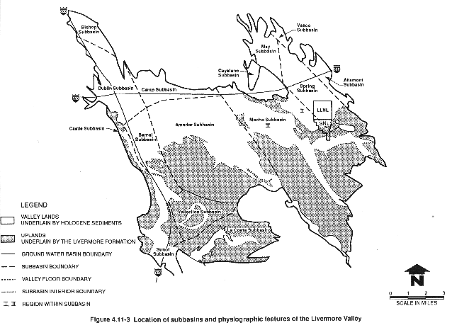
The majority of Livermore Valley sediments are water-bearing and transmit ground water in varying degrees. In contrast, the uplands generally do not yield ground water in sufficient quantities to constitute a ground water resource (California Department of Water Resources, 1974). The Livermore Valley has been divided into a series of 12 ground water subbasins based on the location of faults, topography, and other hydrogeological barriers that affect ground water occurrence, movement, and quality (Figure 4.11-3). While they are distinct operations managed and operated by different contractors, for purposes of this document LLNL Livermore and SNL, Livermore sites are addressed together because of their proximity.
The LLNL Livermore site and SNL, Livermore lie primarily within what are called the Spring and Mocho I subbasins. The water-bearing sediments in the Livermore Valley include late-Pleistocene to Holocene-age alluvial sediments, generally less than 200 ft (61 m) thick, which overlie Plio-Pleistocene alluvial and lacustrine Livermore Formation sediments up to 4000 ft (1219m) thick (Thorpe et al., 1990).
The Livermore Formation consists of beds of gravel, sand, silt, and clay of varying permeabilities. Sandy-gravelly layers alternate with fine-grained, relatively impermeable layers, and ground water can be both confined and semiconfined.
Stream runoff from precipitation and controlled releases from the South Bay Aqueduct, direct rainfall, irrigation, and treated ground water infiltration recharge the Livermore Valley ground water basin (Isherwood et al., 1990). In addition, stream channels and ditches, and gravel pits west of the City of Livermore are important sources for shallow, alluvial aquifer recharge (WESCO, 1988). Ground water is naturally discharged from the basin at Arroyo de la Laguna, located over 11 miles southwest of the LLNL Livermore site. Some minor discharges also occur at springs, including those along Arroyo Las Positas near its confluence with Altamont Creek (Isherwood et al., 1990). Recharge occurs primarily in uplands east and southeast of the LLNL Livermore site and SNL, Livermore. Stream recharge may contribute up to 61 percent by volume of recharge to the basin (Thorpe et al., 1990).
In general, most ground water in the basin flows toward the west central portions of the valley. Ground water generally moves east to west within the Livermore Valley; ground water near the center of the Livermore Valley moves toward the Amador subbasin and terminates in a large ground water depression near gravel mining areas located west of the City of Livermore (Thorpe et al., 1990). This ground water depression is created by extraction of ground water for drinking water use and dewatering for gravel mining. Horizontal hydraulic gradients in the basin vary from about 0.0002 to 0.02 ft/ft (California Department of Water Resources, 1974). Vertical gradients within the Livermore basin are generally downward with lower hydraulic head in deeper sediments. Vertical gradients are typically less than 0.05 ft/ft except in areas of significant pumping. The vertical gradients in the vicinity of California Water Service Company production wells and central Livermore wells are about 0.2 ft/ft.
Pumping ground water for agricultural uses has historically accounted for the major withdrawal of ground water from the Livermore Valley ground water basin. As the valley has become increasingly urbanized, a shift in ground water users has caused the amount of pumping for municipal use and gravel quarrying to exceed agricultural withdrawals in the Livermore Valley. In the vicinity of the LLNL Livermore site, agricultural withdrawals are still a major source of drawdown (Thorpe et al., 1990; Dresen et al., 1991).
LLNL Site 300
LLNL Site 300 lies on the eastern flank of the Diablo Range (Lamarre, 1989). Most surface runoff and most ground water flows toward the San Joaquin Valley. Runoff that concentrates in Elk Ravine and Corral Hollow Creek recharges local bedrock aquifers here. The regional ground water table beneath LLNL Site 300 largely occurs within sandstone and conglomerate beds of the Neroly Formation, and ground water moves through both pores and fractures (McIlvride et al., 1988; Raber and Carpenter, 1983). A deep confined aquifer (400 to 500 ft (122 to 152 m) deep) is present beneath the southern part of LLNL Site 300 within the lower Neroly Formation sandstones, and this confined aquifer provides the LLNL Site 300 water supply (Lamarre, 1989). Pumping tests performed in the LLNL Site 300 water supply wells (McIlvride et al., 1990) affirm the integrity of the aquitard separating the shallow and deeper aquifers within the lower Neroly Formation. In addition to the regional aquifers, local perched aquifers containing small amounts of water occur in some deposits within the Neroly Formation and the marine Tertiary sequence (see Webster-Scholten et al., 1991). These localized perched aquifers are not potential water supply sources.
4.11.2.2 Local Hydrogeology
The following section describes the local hydrogeology for the LLNL Livermore site, LLNL Site 300, and SNL, Livermore.
Waterbearing Units
LLNL Livermore Site and SNL, Livermore
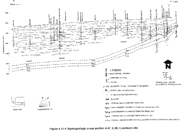
Figure 4.11-4 shows the major waterbearing units beneath the LLNL Livermore site. Similar waterbearing sediments are found beneath SNL, Livermore. These waterbearing units include deposits formed during the late Pleistocene to Holocene and are composed of shallow heterogenous, unconsolidated alluvium and deep fluvial and lacustrine sediments (Thorpe et al., 1990). The permeable sediments, shown as lenses on Figure 4.11-4, are separated by low-permeability silt and clay layers, generally 15 to 60 ft (5 to 18 m) thick. These silt and clay layers may comprise a regional confining layer. The confining layer slopes westward and varies in depth from about 60 ft (18 m) beneath the eastern edge of the LLNL Livermore site to about 400 ft (122 m) near the western site boundary (Thorpe et al., 1990).
LLNL Site 300
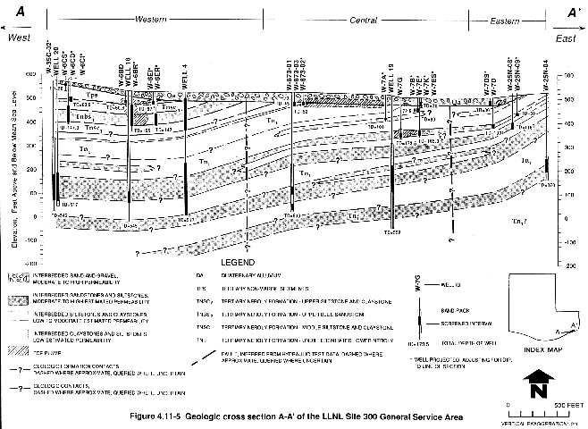
Two regional aquifers or major waterbearing zones have been identified at LLNL Site 300: an upper water table aquifer in the sandstones and conglomerates of the Neroly Formation, and a deeper confined aquifer located in Neroly sandstones just above the Neroly/Cierbo contact (UC, 1987). Both aquifers have permeable zones layered with lower permeability claystones, siltstones, or tuffs. Many of the sandstones are fine grained and silty and contain fractures. Ground water flow is both intergranular and fracture flow. In addition to the two regional aquifers, several perched aquifers have been identified, some of which give rise to springs. Extensive perched aquifers are present beneath the Pit 7 area and the Building 834 Complex (Raber and Carpenter, 1983). In addition, shallow Quaternary alluvium and undifferentiated Tertiary nonmarine sediments are locally waterbearing such as at the General Services Area (see Figure 4.11-5) and these local aquifers are generally unconfined or water table aquifers.
Occurrence of Ground Water
LLNL Livermore Site and SNL, Livermore
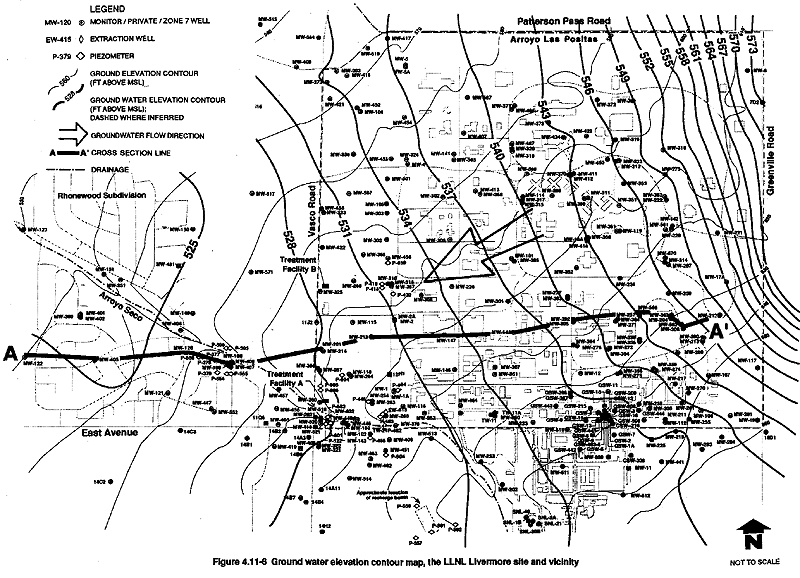
Depth to ground water at the LLNL Livermore site varies from about 110 ft (34 m) in the southeast corner to 30 ft (9 m) in the northwest corner. The water table surface in June 1991 is shown in Figure 4.11-6. The depth to ground water at SNL, Livermore in March 1991 ranged from 110 ft (34 m) in the northwest corner near the Fuel Oil Spill to 122 ft (37 m) in the vicinity of the Navy Landfill in the southern portion of the site. Perched aquifer ground water levels ranged from about 24 ft (7 m) near Arroyo Seco to about 45 ft (14 m) at the Navy Landfill site (SNL, Livermore, 1991e). Figure 4.11-5 (Geologic cross section A-A¢ through the southern General Services Area) shows waterbearing units typically found at LLNL Site 300.
Ground water beneath the eastern Livermore Valley has generally been rising (WESCO, 1988; Thorpe et al., 1990) because there has been a decrease in volume of ground water pumped for agricultural uses and by LLNL over the past 20 years (California Department of Water Resources, 1974; Stone et al., 1982). Ground water levels rose more rapidly from 1979 through 1981 in response to artificial recharge due to releases of surface water from the South Bay Aqueduct into Arroyo Seco (WESCO, 1988). From 1981 to 1987, ground water levels at the LLNL Livermore site and SNL, Livermore rose an average of 13 ft (4 m) in wells measured over that period (Thorpe et al., 1990). As a result of abnormally low rainfall from 1987 through 1991, ground water levels at the LLNL Livermore site and SNL, Livermore have stopped rising, and have declined in many wells (Thorpe et al., 1990). For example, monitor wells at SNL, Livermore have generally shown a decline of about 10 ft (3 m) between 1986 and 1991 (SNL, Livermore, 1991e).
LLNL Site 300
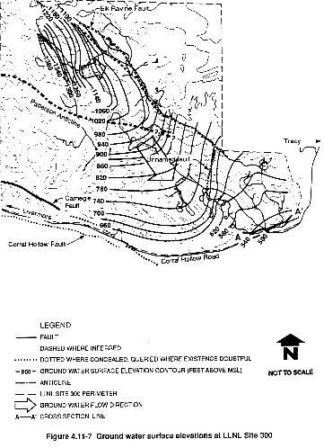
Ground water elevation in the Neroly, lower blue sandstone aquifer at LLNL Site 300 is controlled largely by geologic structure (Figure 4.11-7). Ground water occurrence in local perched aquifers is often dictated by geologic structure, including faulting and dip of layers or strata, the permeability and impermeability of alternating bedrock units, and recharge and discharge.
The majority of the hydrographs for LLNL Site 300 showed decreases during the period between mid-1984 and early 1989 (Buddemeier et al., 1987c; Lamarre, 1989). Declines ranged from 13 ft (4 m) to less than 2 ft (1 m). A rise in water levels (due to high-intensity rainstorms) was observed during the winter of 1985–1986 in some wells.
The general water level decline, plus the rapid rise discussed above, may be related to rainfall patterns over LLNL Site 300. Peak winter rainfall has declined constantly since the 1983–1984 winter, although there was higher rainfall during the 1985–1986 winter. The variability in ground water level declines across LLNL Site 300 may be attributed to the variation in monitor well zones of completion because some wells are completed in highly variable perched zones, and others in relatively stable deeper aquifers. The general ground water level decline observed in the LLNL Site 300 area is consistent with the trends observed at the LLNL Livermore site and vicinity, at SNL, Livermore, and throughout the Alameda County Flood and Water Conservation District, Zone 7 (Buddemeier et al., 1987c; Lamarre, 1989). As discussed in McIlvride et al. (1990), it is unlikely that declines are the result of drawdowns in water supply wells, because the aquifers in the General Services Area are reportedly not in communication with the shallow aquifers.
Ground Water Flow
LLNL Livermore Site and SNL, Livermore
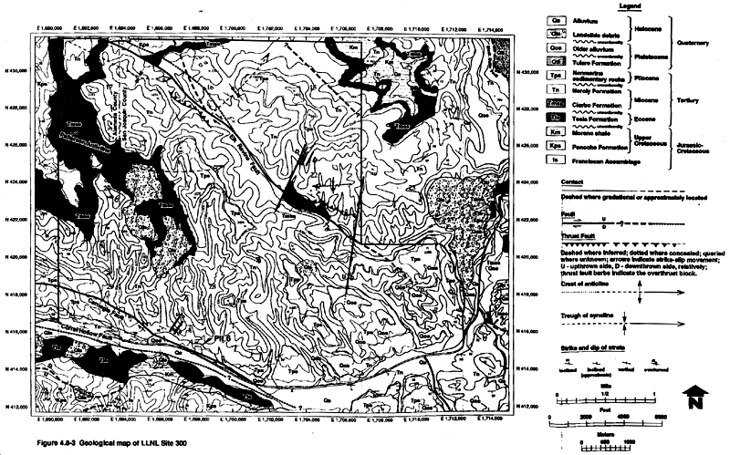
Ground water at the LLNL Livermore site and vicinity generally flows westward (Thorpe et al., 1990). Ground water from the northern half of the LLNL Livermore site eventually discharges to Arroyo Las Positas near First Street, about 1.5 miles northwest of the site. Ground water from the southern half of the LLNL Livermore site and SNL, Livermore may flow westward through the mapped gap between the Mocho I and Mocho II subbasins (see Figure 4.8-3), about 1.5 miles west of the LLNL Livermore site, where it may continue to flow westward toward the municipal well field near central Livermore. The majority of sediments are hydraulically continuous between the Mocho I and Mocho II subbasins (Sorensen et al., 1984). Although the magnitude and direction of ground water flow in the Mocho I–Mocho II gap are uncertain, it is conservatively assumed that at least some ground water from the LLNL Livermore site exits the Mocho I subbasin in this area (Thorpe et al., 1990).
In addition to the general westerly flow, there is a southwesterly ground water flow in the southeast area of the LLNL Livermore site. The ground water gradient is steepest near the northeast corner of the LLNL Livermore site and at the southeast corner near the Las Positas fault (about 0.15 ft/ft), and decreases to between 0.001 and 0.005 ft/ft west of the site (Thorpe et al., 1990). Hydraulic heads in wells at the LLNL Livermore site decrease with increasing depth, indicating downward vertical gradients (Isherwood et al., 1990). The vertical component of the hydraulic gradient reportedly increases in and near the regional confining layer. Vertical gradients are typically lower in the shallow saturated alluvium west of the site where the confining layer in the Lower Member of the Livermore Formation is deeper, and increase near the eastern margin of the site where the confining layer is closer to the ground surface. Vertical gradients generally range from as high as 0.23 ft/ft (downward) near the eastern margins to less than 0.03 ft/ft (downward) at the western edge of the LLNL Livermore site.
Based on the results of extensive long-term hydraulic testing, the hydraulic conductivity of sediments beneath the site is highly variable, with a geometric mean of 4.3 ft/day (Isherwood et al., 1990). Aquifers in the southwest quadrant of the LLNL Livermore site and the adjacent offsite area have the highest average hydraulic conductivity. There is a greater abundance of coarse-grained deposits in the area, possibly the location of ancient channels of Arroyo Seco (Thorpe et al., 1990). In contrast, the southeast quadrant of the area including the LLNL Livermore site and SNL, Livermore has the lowest average hydraulic conductivity and the greatest abundance of fine grained sediments. Based on pumping tests, there also appears to be more vertical connection between aquifers in the southwest corner and offsite from the LLNL Livermore site and SNL, Livermore.
Estimated ground water flow rates beneath the LLNL Livermore site range from about 1 to 75 ft/year. The wide range in flow rates reflects the broad range of ground water gradients, and lithologies and associated hydraulic conductivities for the affected aquifer (Upper Member of the Livermore Formation). Aquifer tests performed by LLNL in the vicinity of SNL, Livermore indicate hydraulic conductivities ranging from 3.3 ft/day to about 52 ft/day (Brown and Caldwell, 1990). The observed hydraulic gradient is about 0.003 ft/ft with a general northwesterly ground water flow direction. The calculated ground water velocity for the Upper Member of the Livermore Formation at SNL, Livermore is therefore 16 to 295 ft/year.
LLNL Site 300
The direction of ground water flow in the deep confined aquifer at LLNL Site 300 is thought to be controlled primarily by the sandstone beds there (Raber and Carpenter, 1983). North of the Patterson Anticline, as far as the Elk Ravine fault, flow directions are thought to be generally to the northeast also along the beds (see Figure 4.11-7). South of the anticline flow is generally southeasterly, with a more eastward component in the vicinity of the General Services Area (UC, 1987).
Estimated ground water flow rates in the Shallow Quaternary alluvial gravels at the General Services Area (see Figure 4.11-5) range from 1 to 10 ft/day (or about 365 to 3650 ft/year). The estimates of ground water flow rates for bedrock aquifers at LLNL Site 300 range from about 0.008 to 4 ft/day (or from about 2.9 to 1460 ft/year). Similarly, the wide range of estimated flow rates reflects the broad range of ground water gradients, and lithologies and associated hydraulic conductivities.
4.11.2.3 Water Use
LLNL Livermore Site and SNL, Livermore
Water used at the LLNL Livermore site is purchased primarily from the City of San Francisco Hetch Hetchy Aqueduct system and from the Alameda County Flood and Water Conservation District, Zone 7. In 1990, 259.8 million gal of water (93.4 percent) were derived from the Hetch Hetchy aqueduct and 19.57 million gal of water (6.6 percent) were derived from Zone 7 (Thorpe et al., 1990). At the LLNL Livermore site, water is primarily used for industrial cooling processes, sanitary systems, and irrigation. Minor amounts of water are used for drinking, manufacturing, washing, system filters, boilers, and a swimming pool (Thorpe et al., 1990). Water used at SNL, Livermore is included in the metered totals of the LLNL Livermore site. The SNL, Livermore estimated usage ranges from 13.5 to 18.7 percent of the total combined usage of the LLNL Livermore site and SNL, Livermore (LLNL, 1990i).
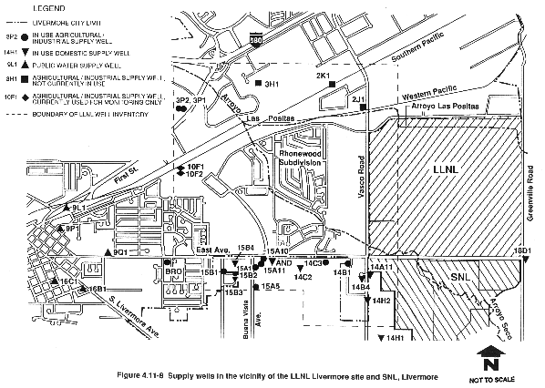
Water for commercial, residential, and agricultural use in the vicinity of the LLNL Livermore site and SNL, Livermore is derived from private wells, Zone 7, City of Livermore wells, and California Water Service Company (CWSC) wells (Figure 4.11-8). The CWSC municipal water supply for Livermore comes from the Mocho II subbasin (Thorpe et al., 1990).
Ground water from the Mocho II subbasin is extracted from five supply wells located west of the LLNL Livermore site. This well water is blended with water purchased from Zone 7 and distributed to about 9500 people near central Livermore. The closest CWSC well (9Q1) is located about 2 miles west of the LLNL Livermore site (Figure 4.11-8). This well is 576 ft (176 m) deep. The remainder of households in the City of Livermore are served by water from Zone 7 (Thorpe et al., 1990).
Ten private active domestic supply wells are known to be located in the vicinity of the LLNL Livermore site and SNL, Livermore (Figure 4.11-8). Well 14A11 is the closest domestic well, located about 600 feet (183 m) south of East Avenue (Thorpe et al., 1990). The well inventory identified ten wells used for agriculture (including watering lawns and gardens) and industrial supply (Thorpe et al., 1990). Of these, well 14B1 is located nearest the LLNL Livermore site, about 200 ft (61 m) south of East Avenue. The main agricultural ground water user in the vicinity is the Wente Brothers Winery. Ground water for the winery is pumped from Well 14C3 during periods of peak water demand. Twenty-five other wells were used until recently for domestic or agricultural supply.
Thirty-one wells (including 6 monitoring wells and 25 other wells), which were potentially affected by or could have potentially served as vertical conduits for ground water contamination, were permanently sealed by LLNL between 1984 and 1990 (McDonald et al., 1991). Users were then connected to the municipal water system. Table 4.11-1 summarizes public and private well information for the LLNL/SNL vicinity.
LLNL Site 300
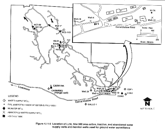
The locations of active and inactive water supply wells at LLNL Site 300 and in the vicinity are shown on Figure 4.11-9. Water used at LLNL Site 300 is derived from two ground water supply wells (W-18 and W-20) located in the southeastern part of the site (see Figures 4.11-5 and 4.11-9). Approximately 29.8 million gal of water were extracted from these wells in 1990, with more than 99 percent of the water pumped from supply well W-20. Another potable water supply well (Ranger well) is located offsite on private land near the south central border of LLNL Site 300 (Taffet et al., 1991). This well supplies water to the Carnegie Vehicle Recreation Park. Well 1, located in the northern portion of LLNL Site 300, is used as an emergency backup well for firefighting only. Four offsite wells are located south of the General Services Area on private rangeland. Two of the wells (CON2 and GALLO1) are currently inactive. The other two offsite wells (CDF-1 and CON-1) are active. Well CDF-1 operates intermittently to fill a pressure tank that supplies the nearby Castle Rock Department of Forestry living quarters and office. Well CON-1 is pumped intermittently and supplies the nearby Connolly Ranch, mainly for stock watering.
4.11.2.4 Background Ground Water Quality
LLNL Livermore Site and SNL, Livermore
Ground water in the vicinity of the LLNL Livermore site and SNL, Livermore is generally suitable for use as a domestic, municipal, agricultural, and industrial supply; however, industrial and agricultural uses of some shallower ground water may be limited by its marginal quality. Furthermore, ground water less than about 300 ft (91 m) deep is usually unsuitable for domestic use without treatment (Thorpe et al., 1990).
Water quality data representative of wells screened in the aquifers system under investigation at the LLNL Livermore site and SNL, Livermore vicinity are shown in Table 4.11-2 (Thorpe et al., 1990). Ground water in the vicinity is mostly a calcium-bicarbonate type, with sodium-chloride waters to the northeast (Thorpe et al., 1990). The maximum concentrations observed for most metals exceed EPA drinking water maximum contaminant levels (MCLs); however, the maximum concentrations are usually from limited areas. Elevated levels of sodium, hardness, total dissolved solids, specific conductance, and nitrate also exceed EPA water quality standards. High concentrations of boron, chloride, and sulfate also limit the use of this ground water for irrigation. Samples from the Mocho I and II subbasins (see Figure 4.8-3) have shown that some ground water is classified as Class II and Class III for irrigation, largely due to high boron concentrations (Thorpe et al., 1990). The high bicarbonate and calcium concentrations may limit the use of this ground water for livestock. High concentrations of chromium, lead, and manganese may limit the discharge of this ground water to surface water drainages.
Ground Water Contamination
Volatile organic compounds including perchloroethylene, trichloroethylene, 1,2-dichloroethylene, 1,1-dichloroethylene, 1,1,1-trichloroethane, 1,2-dichloroethane, 1,1-dichloroethane, carbon tetrachloride, and chloroform have been detected in the ground water onsite and around the LLNL Livermore site. In 1990, DOE and UC sponsored a Baseline Public Health Assessment to address the future public health risk absent any cleanup (Thorpe et al., 1990). The assessment estimated the maximum individual exposure concentrations over a 70-year lifespan for both existing and hypothetical impacted offsite wells. Hypothetical exposures to volatile organic compounds were estimated for ingestion of tap water, inhalation of volatilized compounds during showers, and absorption through the skin from bath water. Hypothetical irrigation exposures resulted from ingestion of home-grown fruits and vegetables watered with contaminated well water and the inhalation of compounds volatilized during sprinkler irrigation (Thorpe et al., 1990).
An estimated maximum cancer risk from domestic use of the municipal supply well in downtown Livermore was 0.2 in a million. The maximum "health conservative fatal lifetime" cancer risk (i.e., using the most conservative assumptions) from domestic use of the same water supply was 1 in 1000, but the contaminated ground water may not reach municipal wells and be available for consumption for another 270 years. The highest predicted risk was 2 in 1000 for exposure to contaminated well waters from a potential well that might be drilled 250 ft west of the LLNL Livermore site. No members of the public are currently exposed to volatile organic compounds from the use of wells near the LLNL Livermore site.
To be more conservative, risks are estimated assuming no remediation occurs (see section 4.19). LLNL is working with the EPA and the State of California to identify appropriate remediation (see section 4.17) (Thorpe et al., 1990).
At SNL, Livermore benzene contamination was found at concentrations of up to 3 ppb in ground water samples in three wells until May 1986. In all subsequent ground water sampling investigations at the fuel oil spill site since May 1986, benzene has not been detected in any well. Two of the wells where benzene was detected in ground water samples have since gone dry.
LLNL Site 300
Ground water quality in the area of LLNL Site 300 has a relatively high concentration of total dissolved solids, though variability in natural water quality has been observed (UC, 1987). Sodium bicarbonate water is most common in water supply wells and sodium sulfate water is most common in springs. The amount of total dissolved solids ranges from 400 ppm to 4000 ppm in local ground water. Table 4.11-3 shows the range of concentrations for major cations and anions observed in monitor wells and supply wells. Some ground water samples had elevated concentrations of arsenic, fluoride, nitrate, and uranium; however, only arsenic exceeded the maximum contaminant levels in two monitor wells (Raber and Carpenter, 1983; Carlsen, 1991).
Ground Water Contamination
LLNL is currently investigating and identifying the characteristics of the ground water contamination at LLNL Site 300. These investigations are discussed in section 4.17. There is one area, the GSA area, where ground water contaminated with trichloroethylene (TCE) and perchloroethylene (PCE) has migrated offsite in two plumes (Ferry, Lamarre, and Landgraf, 1990).
Evaluations were performed to estimate the potential risks from the General Service Area plumes. After examining the potential routes of exposure, it was determined that potential trichloroethylene and perchloroethylene exposure could occur only through ingestion of ground water; therefore, the only potential exposure sources are water-supply wells. Three private water supply wells (one inactive well, one active well used by the California Department of Forestry, and one by the Connolly Ranch) are located near the plume area. These wells continue to be free of contaminants (McIlvride et al., 1990).
The future worst-case concentrations in the GSA offsite receptor drinking water supply wells were estimated to be 15 µg/L for trichloroethylene and 2.5 µg/L for perchloroethylene. The estimated trichloroethylene concentration in these ground water plumes exceeds the California Department of Toxic Substances Control Maximum Contaminant Level of 5 µg/L. The estimated perchloroethylene concentration is one half of that department's Applied Action Level of 5 µg/L. LLNL is currently performing a baseline public health assessment similar to that undertaken for the LLNL Livermore site. The results of this assessment (and the other risk assessments) will be presented in the Site Wide Remedial Investigation report for LLNL Site 300 that is currently being prepared. The risk assessments will address the additive risks due to all potential and actual chemical releases at LLNL Site 300.
Table 4.11-1 Public and Private Wells in the LLNL Livermore Site and SNL, Livermore Vicinity That Were Investigated During the LLNL Inventorya
| State Well Name | Flow Rate (gpm) | Owner | Use | Comments |
| 2J1 | N/A | Salinas Reinforcing | Irrigation
Industrialb |
Not currently in use |
| 2K1 | N/A | Capital Metals | Irrigationb | Not currently in use |
| 3H1 | N/A | PG&E | Irrigationb | Not currently in use |
| 3P1 | N/A | N/A | Landscape irrigation | Free of VOCsc |
| 3P2 | N/A | Layton | Landscape irrigation | Not tested |
| 9L1, 9P1, 9Q1 | >300d | CA Water Service | Public water supply wellse | Free of VOCs |
| 10F1 | >100d | Hexel Corp. | Industriale | Not tested |
| 10F2 | >100d | Hexel Corp. | Industriale | Not tested |
| 14A11 | N/A | Phillips | Domestice | Free of VOCs |
| 14B1 | >25 | Bargman | Swimming Poolf | Free of VOCs |
| 14B4 | N/A | Speral | Domesticf | Free of VOCs |
| 14C2 | 10g | Wente Bros. | Domesticf | Free of VOCs |
| 14C3 | >500h | Wente Bros. | Crop irrigationf | Free of VOCs |
| 14H1 | N/A | Miller | Domesticf | Free of VOCs |
| 14H2 | N/A | Freyendal | Domesticf | Free of VOCsc |
| 15A1 | 5g | Casen | Landscape irrigationb | Temporarily out of service |
| 15A5 | N/A | McGowan | Landscape irrigationb | Not tested |
| 15A10 | >10g | Livermore Preschool | Landscape irrigationb | Not tested |
| 15A11 | N/A | Fitzgerald | Landscape irrigationb | Temporarily out of service |
| 15B1 | 40h | Leeds | Landscape irrigationb | Not tested |
| 15B2, 15B3 | 30–50g | Almond Circle Homeowners Association | Landscape irrigationb swimming pool and drinking water | Very limited domestic use |
| 15B4 | N/A | Mena | Domestic Supplyb | Not tested |
| 16B1, 16C1 | >200d | California Water Service | Public water supply wellse | Not tested |
| 18D1 | N/A | Williams | Domesticf | Free of VOCsc |
| ANDi | 10g | Anderson | Domestic supplyj | Free of VOCs |
| BROi | 40g | Broadman | Landscape irrigation Livestock and gardenk | Free of VOCs |
aSee Figure 4.11-8 for well locations.
b Not sampled for VOCs. Well is located more
than 0.25 mi from LLNL VOC plume.
c LLNL monitoring shows that this well is free
of VOCs.
d Information regarding estimated flow
rate from current owner/user.
eSample for VOCs by owner. Well is
located more than 0.25 mi from LLNL VOC plume.
fSampled during LLNL quarterly monitoring. Well is located within 0.25 mi
of VOC plume.
g Based on existing records of Alameda
County Flood Control and Water Conservation District, Zone 7.
h Wente activated well in July 1991.
i No existing state well name.
j Sampled for VOCs by LLNL on May 24,
1989. Well is located more than 0.25 mi from LLNL VOC plume. Sample data does
not appear in Appendix D.
k Sampled for VOCs by LLNL in 1984.
Well is located more than 0.25 mi from LLNL VOC plume. Sample data does not
appear in Appendix D.
N/A = information not available. Source: Thorpe et al., 1990.
Table 4.11-2 Inorganic Chemical Water Quality Standardsand Composition of Ground Water at the LLNL Livermore Site and Vicinitya
| Parameter | EPA Drinking Water Maximum Contaminant Level | Irrigation Water | Livestock Feeding Water | Fish and Aquatic Life Limitingc | Range of Background Concentrations Found in Water Samples | ||
| Thresholdb | Limitingc | Thresholdb | Limitingc | ||||
| Arsenic | 0.05d,e | --- | 1.0f | 0.1g | 1.0f | 1.0f | <0.001–0.027 (MW-358)h |
| Barium | 1.0d,e | --- | --- | --- | --- | 5.0f | <0.0001–2.1 (MW-315) |
| Bicarbonate | --- | --- | --- | 500g | 500g | --- | <1–816 (GSW-5) |
| Boron | --- | --- | 0.5f | --- | --- | --- | <0.2–9.1 (MW-8) |
| Cadmium | 0.01d,e | --- | --- | 5g | --- | --- | <0.0001–0.17 (MW-364) |
| Calcium | --- | --- | --- | 500g | 1000g | --- | 4.4–315 (MW-8) |
| Chloride | 500i,e (250 recommended) | 100f | 350g | 1500f | 3000g | --- | 3–610 (MW-8) |
| Chromium (total) | 0.05d,SUP>e | --- | --- | 5.0f | --- | 0.05f | <0.0001–0.56 (11A1) |
| Copper | 1.0i,e | 0.1g | 1.0g | --- | --- | --- | <0.0001–0.09 (MW-314, 364) |
| Fluoride | 1.4–2.4d,j,e | 10.0f | --- | 1.0f | 6g | 1.5f | Not detected 1 ppm L.O.D. |
| Hydrogen sulfide | 1.0k | --- | --- | --- | --- | --- | Not analyzed |
| Iron | 0.3i,e (recommended) | --- | --- | --- | --- | --- | <0.02–6.7 (18D1) |
| Lead | 0.05d,e | --- | --- | --- | --- | 0.1f | <0.001–0.27 (GSW-403.6) |
| Magnesium | --- | --- | --- | 250g | 500g | --- | 0.29–79 (MW-552) |
| Manganese | 0.05i,e (recommended) | 0.5f | --- | 10.0f | --- | 1.0f | <0.01–11 (18D1) |
| Mercury | 0.002d,e | --- | --- | --- | --- | --- | <0.001–0.05 (MW-276) |
| Nitrate (as NO3) | 10d | --- | --- | 200g | 400g | --- | <0.44–71 (MW-355) |
| Selenium | 0.01d,e | --- | --- | --- | --- | --- | <0.001–0.014 (MW-2) |
| Silver | 0.05nd,e | --- | --- | --- | --- | --- | <0.0001–0.08 (MW-406) |
| Sodium | 20i | 60g | 80g | 1000g | 2000g | --- | 21–430 (MW-8) |
| Sulfate | 500i,e | 200f | 1000g | 500f | 1000g | --- | 1.7–900 (18D1) |
| Zinc | 5i,e (recommended) | --- n | --- | --- | --- | --- | <0.01–0.26 (MW-114) |
| TDS | 1000i,e | 500g | 1500g n | 2500g | 5000g | --- | 117–1770 (MW-8) |
| pH (units) | 6.5–8.5i | 7.0–8.5 | 6.0–9.0 | 6.0–8.5 | 5.6–9.0 | --- | 5.8–11.3 (MW-205) |
| Specific Conductance (µmhos/cm) |
1600i,e
(900 recommended) |
2000g | 3000g | --- | --- | --- | 174–3130 (MW-8) |
a All units are mg/L (ppm) unless noted.
b Threshold: a concentration at which a
given beneficial use is not damaged to any measurable degree.
c Limiting: a concentration at which
the beneficial use is severely inhibited.
d U.S. EPA, 1988.
e California Code of Regulations
(1977), Title 22.
f McKee and Wolf (1963). g Todd, D.K.
(1980).
gTodd, D.K. (1980).
h Monitor well with highest concentration is shown
in parentheses.
i National Secondary Drinking Water
Regulations (U.S. EPA, 40 C.F.R. 142, rev. 7/19/79-8/27/80).
j Maximum recommended concentration is
temperature-dependent.
k Critical concentration dependent on
crop and/or animal type.
Source: Thorpe et al., 1990.
Table 4.11-3 Inorganic Water Quality Data for LLNL Site 300 and Vicinity
| Parameter | Minimum Value* | Maximum Value | General Range |
| Sodium | 29 | 560 | 30–300 |
| Potassium | 2 | 15 | 2–14 |
| Calcium | 3 | 170 | 10–120 |
| Magnesium | 0.9 | 110 | 1–50 |
| Nitrates (as NO3) | <0.4 | 120 | <04–100 |
| Chlorides | 29 | 550 | 30–300 |
| Sulfate | 13 | 590 | 30–270 |
| Carbonate | <0.6 | 144 | 0.6–20 |
| Bicarbonate | 130 | 540 | 130–400 |
| TDS | 310 | 1400 | 310–1400 |
| Specific Conductance | n390 | 3350 | 390–2200 |
| pH | 6.7 | 8.8 | 6.7–8.8 |
* Values are in mg/L (ppm), except specific conductance (mmhos/cm) and pH (pH units).
4.11.3 Floodplains
LLNL Livermore Site and SNL, Livermore
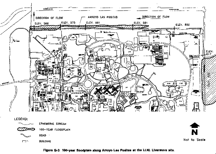
A floodplain is defined as the valley floor adjacent to a streambed or arroyo channel that may be inundated during high water (Linsley et al., 1982). Flood insurance studies were performed for the Federal Emergency Management Agency to determine flood hazards in the Alameda County area, and to identify the approximate limits of the 100-year floodplain. These floodplains were incorporated in the Flood Insurance Rate Maps (FEMA, 1981; 1986). Maps depicting the 100-year floodplains for the LLNL Livermore site and SNL, Livermore are presented in Appendix G (Figures G-3 and G-4). Arroyo Las Positas and Arroyo Seco, dry for most of the year, are the two potential sources of flooding onsite. Localized flooding is most likely to occur during the rainy season from October to April. Open ditches and storm drains that are designed for a 10-year storm event drain both sites. Most of the LLNL Livermore site ultimately drains to the north into Arroyo Las Positas, and a small percentage of land in the southwest corner drains southward to Arroyo Seco. All of SNL, Livermore drains into Arroyo Seco.
Arroyo Las Positas is an intermittent stream that drains approximately 3300 acres in the northeastern and eastern hills above the LLNL Livermore site. This arroyo has a maximum predicted 100-year base flood peak flow adjacent to the LLNL Livermore site of 822 cu ft/second (Holmes and Narver, Inc., 1985). The 100-yr floodplain broadens as it approaches the LLNL Livermore site from the east from 100 ft wide to 1500 ft wide covering Greenville Road. The spreading is due to the shallow channel depth that cannot contain the 100-year flood. The 100-year flood flow is contained within the Arroyo Las Positas channel as it is conveyed northward along the eastern site perimeter and then westward along the northern boundary of the LLNL Livermore site. As the Arroyo approaches the northwest corner of the site, the 100-year flood flow exceeds the channel banks to a width of 120 ft. Storm flow within the northern perimeter channel combines with the western area drainage at the northwest corner of the site. The flow is conveyed to the north, beyond the site, within a drainage easement managed and maintained by LLNL. Approximately 1000 feet to the north, storm flows are directed westward along the Western Pacific Railroad right-of-way.
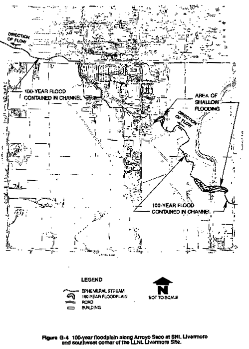
Arroyo Seco is an intermittent stream that drains the foothills to the southeast of SNL, Livermore. It has a drainage length of approximately 12 miles and has a watershed area of approximately 8960 acres upstream of SNL, Livermore. The channel is narrow and shallow as it enters SNL, Livermore from the east and reaches a depth of 20 ft further downstream as it leaves the site to the northwest. Storm water from SNL, Livermore is collected and channeled to Arroyo Seco through gutters, culverts, and open ditches. Arroyo Seco has a 100-year base flood peak flow of 1220 cu ft/second that is contained within the channel through most of the site (Holmes and Narver, Inc., 1985). This flood would breach the channel banks at one location approximately 3000 ft upstream of East Avenue. There is no overbank flooding from Arroyo Seco as it passes through the LLNL Livermore site property because the channel is deep and able to contain the flood waters.
LLNL Site 300
LLNL Site 300 is primarily on undeveloped land characterized by steep hills and deep ravines. A floodplain analysis was conducted for this site to determine the depth and width of inundation due to the 100-year storm event. Details of this analysis are presented in Appendix G. Three drainages (Oasis/Draney, Elk, and Middle) serve as pathways for stormwater runoff and were used as representative drainages for the analysis. The watersheds associated with three of these ravines are presented in Appendix G (Figure G-2) and the peak runoff was computed using the U.S. Army Corps of Engineers Hydrologic Engineering Center Flood Hydrograph Package (U.S. Army Corps of Engineers, 1981). The computed hydrographs at the outlet of each basin provide the peak flows for the 100-year flood event. The results indicated peak flows of 91 cu ft/second for Middle Canyon (13.9-ft width), 367 cu ft/second (19.5-ft width) for Elk Ravine, and 355 cu ft/second (19.6-ft width) for Oasis/Draney Canyon.
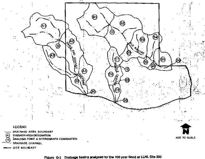
Based on the results, there are no floodplains on LLNL Site 300 as the 100-year base flood event is contained within all channels. However, due to the steep slopes and high runoff potential velocities within these channels could be excessive during a storm.
|
NEWSLETTER
|
| Join the GlobalSecurity.org mailing list |
|
|
|