


APPENDIX I SEISMIC SAFETY PROGRAM
I.1 INTRODUCTION
The purpose of this appendix is to analyze the potential for earthquake-induced damage to structures and equipment containing hazardous and/or radioactive materials, and to structures and equipment important for emergency response to hazardous and/or radioactive material releases. The general description in section I.2 briefly highlights the main steps undertaken in order to make these analyses.
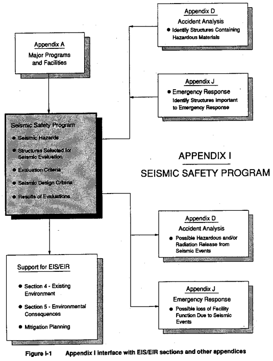
The relationship of this appendix to others, and to Sections 4 and 5 of the EIS/EIR, is shown in Figure I-1. The results of this appendix are used in Appendix D to estimate onsite and offsite potentials for dispersals of hazardous and/or radioactive materials due to an earthquake; and in Appendix J, where emergency planning and response is discussed.
Throughout Appendix I both English units (feet, inches, etc.) and metric units (meters, centimeters, etc.) of measurement are used. The use of different measurements in different parts of the appendix, often within the same section, occurs primarily because the appendix attempts to report data strictly as presented by the referenced source. Rather than converting all measurement data to a single set of units, conversion equations for the most common units are provided in the Glossary at the end of this appendix.
I.2 GENERAL DESCRIPTION OF APPENDIX I CONTENTS
In the following sections I.3 through I.6, the steps undertaken to analyze potentials for earthquake-induced damage are discussed. The main steps were:
- Identifying structures and equipment for which a prediction is necessary;
- Obtaining the original design calculations (or any more recent evaluations that may exist) that address the seismic capacities of the building and critical equipment;
- Defining the seismic hazards to which the structures and equipment would be subjected, based on the most recent site-specific seismological studies available;
- Selecting criteria for evaluating whether or not the seismic strength of the structures and equipment is adequate to resist the seismic hazards;
- Developing and implementing a methodology that utilizes the selected criteria in a simplified manner so that a number of different types of structures and equipment could be evaluated. The developed methodology utilizes the original design calculation, or more recent reevaluation (and the seismic design criteria upon which they were based), as the basis from which extrapolations are made in developing predictions of current seismic adequacy; and
- Performing the comparison of the seismic strength of structures and equipment to the seismic hazards postulated to act on them.
Structures and equipment with seismic strength inadequate to meet the criteria in section I.5 when subjected to the forces from the postulated earthquake were assumed to sustain damage. Building function was assumed to be lost, and hazardous and/or radioactive material confinement was assumed to be compromised as described in Appendix D. Section I.7 describes the historical seismic design criteria used at LLNL and SNL, Livermore.
Section I.8 summarizes the predicted potentials for loss of hazardous/radioactive materials confinement and/or building function, and provides guidance in interpreting the tabular results.
Two major conservative assumptions were made in arriving at the predictions described in section I.8. When a structure or piece of equipment was found not to meet current seismic strength requirements, it was assumed to be deficient to the point where hazardous and/or radioactive material release was possible. Also, if no existing seismic documentation could be found for a particular structure, it was assumed not to meet seismic strength requirements.
I.3 SELECTION OF STRUCTURES FOR SEISMIC EVALUATION
Structures and equipment were evaluated for seismic response for two reasons: (1) they contain quantities of hazardous and/or radioactive materials that are in a dispersable form such as gases or powders that could become airborne, or (2) they are considered important for emergency response to a seismic event that could release hazardous and/or radioactive materials. (These structures and equipment are hereafter referred to as "emergency response structures.") Sources identifying structures that contain hazardous and/or radioactive materials were reviewed and verified as described in Appendix D. Identification of structures important to emergency response is discussed in Appendix J. The complete list of structures evaluated is provided in section I.8.
LLNL Livermore Site
Most of the structures at LLNL which were identified in Appendix D as representing the bounding cases for potential accidental releases of dispersable hazardous and/or radioactive materials, were already listed by LLNL as either moderate or high hazard in accordance with DOE Order 5481.1B. The other buildings identified in Appendix D to be of concern from the standpoint of potential releases were listed by LLNL as low hazard. These were Buildings 141, 151, 166, 322, 518, and the 490 complex. As identified in Appendix D, only Building 493 within the 490 complex represented an accidental release scenario with potentially bounding consequences. The structures at LLNL identified in Appendix J as important to emergency response, and evaluated here in Appendix I, were not given a hazard ranking by LLNL. However, structural calculations reviewed treated these structures as moderate or high hazard. It should be noted that not all structures classified by LLNL as moderate hazard required evaluation. It was determined that the dispersable quantities of radioactive and/or hazardous materials in some structures were too low to model in an accident analysis, even assuming a seismic reaction resulting in maximum dispersion of materials. For some hazardous or radioactive materials, such a reaction would be a structural collapse followed by a fire; for others it would be structural collapse followed by inundation by water (e.g., from broken water pipes). Examples of moderate hazard structures not requiring seismic evaluation are Building 854, Dynamic Test Facility, and Building 191 High Explosives Applications Facility. While these structures represent a potential health and safety hazard because of the presence of high explosives, they do not contain dispersable radioactive or hazardous materials.
LLNL Site 300
No structures at LLNL Site 300 were identified as containing sufficient quantities of dispersable hazardous material to warrant concern; therefore, emergency response structures at LLNL Site 300 would not be needed to mitigate the consequences of releases of hazardous materials after an earthquake. For this reason, seismic evaluation of LLNL Site 300 emergency structures was unnecessary for purposes of this EIS/EIR. However, for purposes of assessing risks associated with seismic hazards for future proposed actions at LLNL Site 300, those hazards and applicable design criteria at LLNL Site 300 are provided in this appendix.
SNL, Livermore
At SNL, Livermore the review and limited verification of sources identifying structures that contain hazardous and/or radioactive materials resulted in only two structures identified as requiring a seismic response prediction. Building 968, Tritium Research Laboratory, is evaluated because it contains hazardous and/or radioactive materials. Building 964, Emergency Communications Building, is required to be operational after a seismic event that causes a hazardous and/or radioactive material release at Building 968. As described in Appendix J, all other emergency response operations required after a seismic event that releases hazardous and/or radioactive materials at SNL, Livermore are carried out via the emergency response facilities at the LLNL Livermore site.
I.4 SEISMIC HAZARDS
This section describes the characteristics of the postulated earthquake event as well as the site-specific geologic data which provides the basis for the postulated event.
I.4.1 Seismic Event Definition
As described more fully in section I.5, the primary initiating event considered here is an earthquake with a mean return period of 5000 years. In other words, there is a 1 in 5000 chance that an earthquake producing larger ground accelerations than those postulated would occur in any given year; thus, the annual exceedence probability is 2×10⁻⁴. The key characteristics of this potential earthquake were developed based on site-specific geologic data corresponding to the LLNL and SNL, Livermore areas (see section 4.7 of the EIS/EIR for details of site geology) and are described in detail in section I.4.2. The earthquake would have a 0.8g effective peak ground acceleration (where 1.0g is the acceleration due to gravity) and maximum ground motion amplification factors of 2.12 at 5 percent damping, and 1.64 at 10 percent damping. Mean amplifications were selected for the reasons discussed in section I.5.
Secondarily, an "Above Design Basis" seismic event is also defined. Because the highest design basis event used at either LLNL or SNL, Livermore is a 0.8g, 5000-year return interval earthquake, an Above Design Basis event must exceed this. Consequently, the Above Design Basis event assumes a return period of 10,000 years corresponding to the maximum extension of published data for the LLNL and SNL, Livermore sites as expressed in Geomatrix (1991). This earthquake would have a 0.9g effective peak ground acceleration with the same amplification factors as described above for the 5000-year event. Limiting this event to a 10,000-year return interval is based on the lack of any research (published or unpublished) indicating that a larger magnitude earthquake is conceivable on the local fault systems. As for the 5000-year event, the key characteristics of this earthquake were developed based on site-specific geologic data corresponding to the LLNL and SNL, Livermore areas. As a rough comparison the January 24 and January 27, 1980, Livermore earthquakes, recorded as 5.4 and 5.6 Richter Magnitude events, generated maximum measured peak ground accelerations of 0.26g at a distance of 18 km from the epicenter. The October 17, 1989, Loma Prieta earthquake, recorded as a 7.1 Richter Magnitude event, generated maximum measured peak ground accelerations of 0.68g at a distance of 7 km from the epicenter.
As a comparison with the seismic events evaluated in this study, the 1990 Design and Evaluation Guidelines for DOE Facilities Subjected to Natural Phenomena Hazards, UCRL 15910 (Kennedy et al., 1990), reported that the 1988 Uniform Building Code and the Applied Technology Council recommended a design seismic hazard level which has about a 10 percent frequency of exceedence in 50 years, or about a 2×10⁻³ annual exceedence probability (a return period of 500 years). The most current versions of these two codes are currently used in the design and evaluation of not only common industrial facilities but more important structures such as schools, hospitals, and fire stations. Kennedy et al. (1990) also report that recent probabilistic hazard studies have been performed to assess the governing seismic design ground motions (Safe Shutdown Earthquake) at U.S. commercial nuclear power plants. The design Safe Shutdown Earthquake levels were found to generally correspond to an estimated mean annual exceedence probability of between 10-3 and 10-4 (Kennedy et al., 1990).
I.4.2 Seismicity of LLNL and SNL, Livermore
I.4.2.1 Seismotectonic Setting
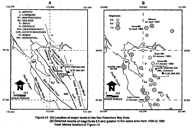
Lawrence Livermore National Laboratory (LLNL) and Sandia National Laboratories, Livermore (SNL) are located in the southeastern portion of Livermore Valley, a fault-bounded valley within the Diablo Range of the Coast Ranges Geologic Province (Figure I-2). The tectonics of the Coast Ranges are characterized by northwest-trending right-lateral, strike-slip faults of the San Andreas fault system. Geological, seismological, and geodetic data all indicate that this fault system accommodates the relative motion between the North American and Pacific plates across a zone approximately 100 km wide (Ellsworth et al., 1981; Prescott et al., 1981). Situated east of the San Francisco Bay, the Laboratory sites are in the vicinity of the transform plate margin of the North American and Pacific plates. At the latitude of LLNL and SNL, Livermore, the faults of the San Andreas fault system include, from west to east, the San Gregorio, San Andreas, Hayward, Calaveras, and Greenville faults (Figure I-2). The Livermore Valley, underlain by thick alluvial deposits, is bounded by the Calaveras fault to the west and the Greenville fault to the east (Figure I-2 and Figure I-3).
East of the Coast Ranges lies the Sierran block, which is composed of the Great Valley and Sierra Nevada Mountain Range. The boundary between the Coast Ranges and Sierran block lies approximately 15 km east of LLNL Site 300 (Figure I-2) and marks a significant change in tectonic structure and seismicity. Recent studies indicate the Coast Range–Sierran block boundary is characterized by east-northeast directed compression, resulting in reverse and thrust faulting (Wong et al., 1988; Wentworth and Zoback, 1989).
I.4.2.2 Historical Seismicity
Preinstrumental
The greater San Francisco Bay Area has experienced several damaging earthquakes since 1800 when the first reported earthquake damage occurred at Mission San Juan Bautista. The historical record of seismicity from 1800 to 1932 is based primarily on the felt effects and damage reported by the population and is considered the preinstrumental record. The instrumental record of seismicity in California is based on the instrumental measurement of earthquakes, which began in 1932 with the establishment of statewide seismographic coverage. Interpretation of the preinstrumental record has provided the approximate locations and magnitudes of many important California earthquakes. Because the preinstrumental record covers a longer period than the instrumental record, it is an important indicator of the larger, less frequent earthquakes (Toppozada et al., 1986).
Significant preinstrumental earthquakes greater than magnitude 5.8 that have occurred in the greater San Francisco Bay Area are shown in Figure I-2 and listed in Table I-1. It can be readily seen that the San Andreas and Hayward faults have repeatedly produced damaging earthquakes in the region. The largest was the great 1906 San Francisco earthquake of estimated magnitude 8.3, which ruptured nearly 450 km of the San Andreas Fault from near Cape Mendocino on the north to San Juan Bautista on the south. This event produced limited damage in Livermore Valley (Lawson et al., 1908). The 1861 Calaveras earthquake (magnitude 6), located along the western margin of Livermore Valley, caused damage in Livermore (Radbruch, 1968).
The Vacaville and Winters earthquakes of 1892 were located north of the LLNL Livermore site and SNL, Livermore along the Coast Range–Sierran block boundary. These two events may have been centered on a blind-thrust fault, similar to the recent 1983 magnitude 6.7 Coalinga and 1985 magnitude 5.7 North Kettleman earthquakes, located to the south along the Coast Range–Sierran block boundary (Eaton, 1986).
With the possible exception of the 1861 earthquake on the Calaveras fault, the Modified Mercalli intensities at the LLNL and SNL, Livermore sites, for the preinstrumental earthquakes shown in Table I-1 are unknown but probably would have been lower than those shown in that table based on the significant distances from the estimated epicenters.
Instrumental
The ability to record earthquakes and their characteristics has increased dramatically since the first seismometers were deployed in the region. Seismic networks today, combined with an increased understanding of crustal structure and velocity models, have not only allowed a greater number of events to be recorded but also increased the amount and resolution of data collected regarding the location, depth, and focal mechanisms for these events. Seismicity can now be used to identify and characterize seismic sources that have not yet been recognized from the surface geology, as well as identify seismic gaps where future earthquakes are more likely to occur.
The seismicity of the eastern San Francisco Bay Area is characterized by both an alignment of earthquake epicenters along major faults and a random distribution of earthquakes that do not display any obvious relation to mapped faults (Ellsworth et al., 1982). While many of the mapped faults are easily identified by a concentration of seismicity, other mapped faults, such as those in the Livermore Valley, are not well defined by seismicity (Ellsworth et al., 1982).
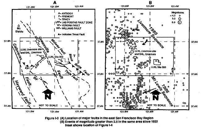
In 1980, LLNL installed a digitally recorded seismic network in the Livermore Valley region to augment the existing U.S. Geological Survey Calnet stations (Scheimer et al., 1982). Seismicity patterns in the valley show a well-defined region of activity along the Greenville fault, which is predominantly associated with the 1980 Livermore earthquake sequence (Figure I-3). The 1986 Mt. Lewis earthquake sequence forms a north-south linear pattern which is not coincident with any mapped fault (Figure I-3). The largest earthquake during this sequence was a ML 5.7 (Person, 1986). A less well defined area of activity may be associated with either the Williams or Valle fault (Figure I-3). In most cases earthquakes are predominantly strike-slip, consistent with generally north-south compression (Scheimer et al., 1982; Followill and Mills, 1982).
Since 1932 there have been only two earthquakes greater than magnitude 6 in the greater San Francisco Bay Area, one event on the southern portion of the Calaveras fault and the other on the San Andreas fault (Table I-2). The earthquake causing the most damage in the Livermore Valley region since the beginning of the instrumental period was the 1980 magnitude 5.5 event that was centered on the Greenville fault approximately 20 km northwest of the LLNL Livermore site (Figure I-3; Bolt et al., 1981). This earthquake, which occurred on January 24, was followed by a series of events, including a magnitude 5.6 shock on January 26 located 14 km south of the main shock (Bolt et al., 1981). The earthquake sequence produced minor amounts of surface rupture along portions of the Greenville fault and perhaps the Las Positas fault. The Greenville fault produced right-lateral displacements up to 25 mm and the Las Positas fault exhibited left-lateral displacements of 1.5 mm across fractures and 6 mm across an alignment array (Bonilla et al., 1980). At the time of the earthquake there were no strong-motion instruments in the Livermore Valley, but estimates of ground acceleration at LLNL ranged from 0.2 to 0.3g (Freeland, 1984).
Table I-1 Preinstrumental Earthquakes Greater Than Richter Magnitude 5.8 in the Greater San Francisco Bay Region for 1800-1932
| Date (year/month/day) | Epicenter Location | Fault | Modified Mercalli Intensitya | Estimated Richter Magnitudea |
| 1836/06/10 | Hayward | Hayward | VIII | 6.8 |
| 1838/06 | San Francisco | San Andreas | VIII | 7.0 |
| 1858/11/26 | San Jose | Hayward | VII | 6.1 |
| 1865/10/08 | Santa Cruz Mtns | San Andreas | IX | 6.3 |
| 1861/07/03 | Amador Valley | Calaveras | VIIIb | ~6.0c |
| 1886/07/15 | North San Joaquin Valley | ? | VI | 5.8 |
| 1881/04/10 | Modesto (or farther west) | ? | VI | 6.0 |
| 1889/05/19 | Antioch | ? | VIII | 6.0 |
| 1868/10/21 | Hayward | Hayward | IX+ | 6.8 |
| 1892/04/19 | Vacaville | ? | IX | 6.4 |
| 1892/04/21 | Winters | ? | IX | 6.2 |
| 1892/04/30 | NE of Vacaville | Midland? | VI | 6.0b |
| 1898/03/31 | Napa? | ? | IX | 6.2 |
| 1906/04/18 | San Francisco | San Andreas | IX+ | 8.3 |
| 1911/07/01 | San Jose | Hayward | VII | 6.6 |
a From Toppozada et al., 1986. Note:
Mercalli intensity values are the maximum observed in any location for a
particular earthquake. They may or may not have been located at the epicenter.
See Table I-2 for a description of the Modified Mercalli levels.
b Wong et al., 1988.
c From U.S. Geological Survey, 1982;
Radbruch, 1968.
? Indicates uncertainty expressed by authors in the
referenced text.
Table I-2 Instrumental Earthquakes Greater Than Richter Magnitude 5.5 in the San Francisco Bay Region for 1932-1990
| Date (year/month/day) | Epicenter Location | Fault | Modified Mercalli Intensitya | Estimated Richter Magnitude |
| 1955/09/04 | San Jose? | Calaveras? | VII | 5.5b |
| 1969/10/01 | Santa Rosa? | ? | 5.7b | |
| 1979/08/06 | Coyote Reservoir | Calaveras | VII | 5.8c |
| 1980/01/24 | Livermore | Greenville | VII | 5.5d |
| 1980/01/27 | Livermore | Greenville | VI | 5.6d |
| 1984/04/24 | Morgan Hill | Calaveras | VII | 6.2c |
| 1986/03/31 | Mount Lewis | ? | VI | 5.7e |
| 1989/10/17 | Loma Prieta | San Andreas | VIII | 7.1f |
aToppozada et al., 1986. Note: Mercalli intensity values are the maximum recorded in any location for a particular earthquake. They may or may not have been located at the epicenter. See below for description of Modified Mercalli levels.
MODIFIED MERCALLI INTENSITY SCALE OF 1931
| INot felt except by a very few under especially favorable circumstances. | VFelt by nearly everyone, many awakened, some dishes, windows, etc., broken; a few instances of cracked plaster; unstable objects overturned. Disturbances of trees, poles, and other tall objects sometimes noticed. Pendulum clocks may stop. |
| IIFelt only by a few persons at rest, especially on upper floors of buildings. Delicately suspended objects may swing. | VIFelt by all, many frightened and run outdoors. Some heavy furniture moved; a few instances of fallen plaster or damaged chimneys. Damage slight. |
| III Felt quite noticeably indoors, especially on upper floors of buildings, but many people do not recognize it as an earthquake. Standing motorcars may rock slightly. Vibration like passing of truck. Duration estimated. | VIIEverybody runs outdoors. Damage negligible in building of good design and construction; slight to moderate in well-built ordinary structures; considerable in poorly built or badly designed structures; some chimneys broken. Noticed by persons driving motorcars. |
| IV During the day felt indoors by many, outdoors by few. At night some awakened. Dishes, windows, doors disturbed; walls make cracking sound. Sensation like heavy truck striking building. Standing motorcars rocked noticeably. | XSome well-built wooden structures destroyed; most masonry and frame structures destroyed with foundations; ground badly cracked. Rails bent. Landslides considerable from river banks and steep slopes. Shifted sand and mud. Water splashed (slopped) over banks. |
| VIIIDamage slight in specially designed structures; considerable in ordinary substantial buildings, with partial collapse; great in poorly built structures. Panel walls thrown out of frame structures. Fall of chimneys, factory stacks, columns, monuments, walls. Heavy furniture overturned. Sand and mud ejected in small amounts. Changes in well water. Persons driving motorcars disturbed. | XIFew, if any, (masonry) structures remain standing. Bridges destroyed. Broad fissures in ground. Underground pipelines completely out of service. Earth slumps and land slips in soft ground. Rails bent greatly. |
| IXDamage considerable in specially designed structures; well-designed frame structures thrown out of plumb; great in substantial buildings, with partial collapse. Buildings shifted off foundations. Ground cracked conspicuously. Underground pipes broken. | XIIDamage total. Practically all works of construction are damaged greatly or destroyed. Waves seen on ground surface. Lines of sight and level are distorted. Objects are thrown upward into the air. |
b Uhrhammer, 1986.
cUhrhammer and Darragh, 1984.
d Bolt et al., 1981.
ePerson, 1986.
f McNutt and Sydnor, 1990.
? Indicates uncertainty expressed by authors in the referenced text.
I.4.2.3 Seismic Sources
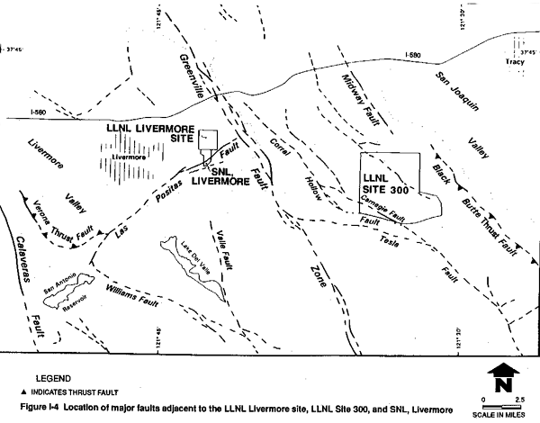
The three principal strands of the San Andreas fault system, the San Andreas, Hayward, and Calaveras faults, have produced the majority of significant historical earthquakes in the San Francisco Bay Area. As these three faults also accommodate the majority of dextral motion across the Pacific–North American plate boundary, they would likely continue to generate moderate to large earthquakes more frequently than other faults in the region; however, it is the local faults in the Livermore Valley region that contribute the majority of the seismic hazard to LLNL and SNL, Livermore (Figure I-4; TERA Corporation, 1983; Scheimer, 1985). Based on probabilistic seismic hazard analyses, the largest contribution to the ground-shaking hazard (in terms of both magnitude and return interval) at the LLNL Livermore site is produced by moderate earthquakes on the Greenville, Las Positas, Verona, and Calaveras faults (Geomatrix Consultants, 1985; Scheimer, 1985). Larger earthquakes on more distant faults such as the San Andreas do not significantly affect the hazard estimation.
For seismic hazard assessments, various criteria have been proposed for defining an "active fault." The State of California defines a fault as active if it displays evidence of displacement within the last 11,000 years (Hart, 1988). The U.S. Army Corps of Engineers, in evaluating critical facilities, defines a fault as active if it shows evidence of having displaced materials approximately 35,000 years old or younger. The U.S. Nuclear Regulatory Commission defines a fault as active if it shows evidence of a single rupture in the last 35,000 years or multiple displacements within the last 500,000 years. The LLNL Site Seismic Safety Project staff has decided to consider a fault that has displaced materials of 35,000 years or younger as active (Carpenter et al., 1984).
San Andreas Fault
The LLNL Livermore site and SNL, Livermore lie approximately 58 km northeast of the San Andreas fault (Figure I-2), which traverses over 1100 km of California. The San Andreas fault is responsible for generating great earthquakes in 1857 and 1906. The recent 1989 Loma Prieta earthquake of magnitude 7.1, centered approximately 72 km from LLNL and SNL, Livermore, occurred on the southern Santa Cruz Mountains segment of the San Andreas fault. The maximum peak horizontal ground acceleration recorded was 0.65g approximately 7 km from the epicenter and 1 km from the fault (Corralitos station). In Livermore, a strong-motion instrument located approximately 8 km northeast of the LLNL Livermore site recorded 0.04g during the 1989 event (Shakal et al., 1989).
Slip rates for the central and south central segments of the San Andreas fault are 33 mm/yr (Thatcher, 1979) and 33.9 mm/yr (Sieh and Jahns, 1984) using geodetic and geologic data, respectively. Due to the partitioning of slip from the San Andreas fault to the Hayward and Calaveras fault zones, slip-rate estimates decrease northward to 22 mm/yr near Olema (Niemi and Hall, 1991) and 23 mm/yr at Point Arena (Prentice, 1989).
The Working Group on California Earthquake Probabilities (1990) has estimated 30-year conditional probabilities of 23 percent for a magnitude 7 event occurring on the San Francisco Peninsula segment, and 2 percent for a magnitude 8 event occurring on the north coast segment of the San Andreas fault.
Hayward Fault
The strike-slip Hayward fault is approximately 80 km long and extends along the eastern margin of the San Francisco Bay plain from Suisun Bay on the north to its convergence with the Calaveras fault southeast of San Jose. The Hayward fault, which lies about 26 km southwest of the LLNL Livermore site and SNL, Livermore (Figure I-3) at its closest approach, is the southern segment of a zone of faulting that extends 280 km northwest to Mendocino County and includes the Rodgers Creek, Healdsburg, and Maacama faults (Slemmons and Chung, 1982).
Historically, the Hayward fault has produced two earthquakes of approximately magnitude 7, in 1836 and 1868, which produced Modified Mercalli Intensities of VIII and IX+ (Toppozada et al., 1986). Both events produced surface faulting on the Hayward fault (Coffman and von Hake, 1973; Radbruch, 1968).
Paleoseismic studies near Fremont (Figure I-3) have revealed evidence of a minimum of five and possibly seven earthquakes in the past 2000 years, inferring a maximum average recurrence time of 250 to 400 years (Williams, 1991). A Holocene slip rate of 7 to 9 mm/yr has been established for the central portion of the Hayward fault where the historic creep rate has been about 5 mm/yr, implying that strain is accumulating on the fault (Lienkaemper and Borchardt, 1991). Galehouse (1990) has measured creep rates of about 4.5 mm/yr at five locations along the Hayward fault for the past 10 years.
The Working Group on California Earthquake Probabilities (1990) has estimated 30-year conditional probabilities of 23 percent and 28 percent for a magnitude 7 event occurring on the southern and northern segments of the Hayward fault.
Calaveras Fault
The Calaveras fault zone is approximately 115 km in length from its southern junction with the San Andreas near Hollister to its northern terminus in San Ramon Valley. The Calaveras fault forms the western margin of Livermore Valley and is located about 17 km west of the LLNL Livermore site and SNL, Livermore (Figure I-3).
The Calaveras fault has generated several moderate and a few large earthquakes. In 1861 an estimated magnitude 6+ earthquake occurred along the western margin of the Livermore Valley (Amador Valley) and produced strong ground shaking (Radbruch, 1968). More recent events in 1979 and 1984 ruptured adjacent segments of the fault near Coyote Reservoir and Halls Valley. The 1979 ML 5.8 Coyote Lake earthquake ruptured a 22-km segment of the Calaveras fault, while the 1984 ML 6.2 Morgan Hill (Halls Valley) earthquake ruptured a 26-km-long segment immediately north of the 1979 event (Uhrhammer and Darragh, 1984). During the past 11 years near its southern end the Calaveras fault has been creeping at average rates of about 7.5 mm/yr and 11.5 mm/yr at two separate locations, whereas at its northern end in San Ramon Valley almost no creep has been detected for the past 10 years (Galehouse, 1990). Slip along the northern Calaveras fault appears to step across to the Concord–Green Valley fault zone along a northeast-trending conjugate left-lateral fault that produced the April 1990 Alamo earthquake sequence with the largest event of magnitude 4.5 (Oppenheimer and MacGregor-Scott, 1991).
Microseismicity occurs along much of the length of the Calaveras fault except for the 30-km-long segment from Calaveras Reservoir to Dublin, which Oppenheimer and MacGregor-Scott (1991) have identified as a seismic gap capable of generating a magnitude 6.0 to 6.5 earthquake.
Greenville Fault
The northwest-trending central Greenville fault system, consisting of several segments or strands, is located approximately 1.5 km east of the LLNL Livermore site and 3.7 km east of SNL, Livermore (Figure I-4 and Figure I-5). The fault is exposed for over 80 km along its length, from the north end, near Mt. Diablo, to its southern terminus in San Antonio Valley along the eastern side of Livermore Valley (Herd, 1977; Dibblee 1980a, 1980b).
On January 24, 1980, an earthquake of magnitude 5.5 (Bolt et al., 1981) caused discontinuous right-lateral surface displacements along the southeastern branch of the Greenville fault, approximately 20 km northeast of the LLNL Livermore site. Fault-plane solutions indicate a focal depth of 11.8 km (Bolt et al., 1981). The first principal shock was followed by a rapid succession of magnitude 5.0 and 4.0 earthquakes, resulting in a relatively long duration of ground shaking. The earthquake was followed by a series of aftershocks, culminating in a magnitude 5.6 (Bolt et al., 1981) event on January 27, 1980, located 14 km to the south of the first principal shock. The focal depth of the January 27 earthquake was 11.8 km (Bolt et al., 1981). The maximum peak horizontal ground acceleration recorded during the earthquake was 0.26g at Del Valle Reservoir (Freeland, 1984), located 18 km from the epicenter (Figure I-4). Although there were no strong-motion instruments at the LLNL Livermore or SNL, Livermore sites, estimates of accelerations were approximately 0.2 to 0.3g (Freeland, 1984).
The southernmost segment of the Greenville Fault extends for over 36 km. Based on offset stream terraces, the slip rate is estimated at 0.5 to 0.7 mm/yr (Wright et al., 1982). The segment of the fault located east and north of the Laboratories extends approximately 34 km to the north, with slip rates estimated at 0.1 to 0.3 mm/yr based on an offset paleosol (Wright et al., 1982). Immediately following the January 1980 event described above, surface displacements were observed along a 6.2-km length of the fault, with a maximum right lateral displacement of approximately 25 mm (Bonilla et al., 1980). No surface displacements were observed along the northernmost segment of the Greenville Fault. The slip-rate estimates for the Greenville Fault are consistent with the Carpenter et al. (1984) estimated average slip rate of 0.5 to 0.75 mm/yr, based on the apparent right-lateral offset of a Plio-Pleistocene syncline, southeast of the LLNL Livermore site and SNL, Livermore.
Las Positas Fault
The northeast-trending left-lateral Las Positas fault zone, consisting of a northern and southern branch, is located less than 0.5 km southeast of the LLNL Livermore site (Figure I-4 and Figure I-5) along the southeast margin of Livermore Valley (Dibblee, 1980a). The northern branch, which crosses the SNL, Livermore site, can be traced for over 18 km and intersects the Verona and Williams faults to the southwest (Figure I-4; Dibblee, 1980a, 1980c). Left-lateral offsets on modern stream drainages, tonal contrast in soil and vegetation, and a well-defined topographic lineament have been identified along the north branch of the Las Positas fault. The most significant historical earthquake tentatively assigned to the Las Positas fault zone occurred on June 11, 1903, with an estimated magnitude of 5.5 (Wong and Biggar, 1989). Minor aseismic slip along the southern branch of the Las Positas may have been triggered by the January 1980 Greenville earthquakes (Bonilla et al, 1980). Left-lateral displacement, approximately 1.5 mm across fractures and 6 mm across an alignment array, was reported by Bonilla et al., (1980). In the following weeks two events, ML 2.6 on February 12, 1980, and ML 3.2 on February 21, 1980, produced minor ground shaking at the LLNL Livermore site (Scheimer et al., 1982). Peak ground accelerations from these earthquakes were approximately 0.04g (Scheimer et al., 1982). The February earthquakes occurred quite close to ground fractures documented by Bonilla et al. (1980). Slip rates for the Las Positas fault zone were determined by different lines of geologic evidence, including offset late Quaternary erosion surfaces and colluvial deposits. The estimated average slip rate for the northern branch ranges from 0.05 to 0.9 mm/yr and for the southern branch from 0.3 to 0.5 mm/yr (Carpenter et al., 1984). The overall estimated slip rates for the Las Positas fault zone are broadly similar to the calculated rates for the Greenville fault. It is likely that motion on the Greenville Fault may trigger slip along portions of the Las Positas fault (Bonilla et al., 1980). An active growth anticline may be presently forming between the two branches of the Las Positas fault and beneath the southernmost edge of SNL, Livermore. Evidence for a growth structure is provided by the presence of topographically high wind gaps and isolated hills that are underlain by deformed Plio-Pleistocene gravels (Shlemon and Qualheim, 1991).
Verona Fault
The arcuate, northwest-trending Verona fault is approximately 6 km long and is located approximately 9 km southwest of the LLNL Livermore site and SNL, Livermore (Figure I-4; Herd, 1977). The fault is truncated by the Las Positas fault to the southeast and by the Calaveras Fault system to the northwest (Rogers, 1966; Herd, 1977). The Verona fault, a moderately to steeply dipping reverse fault, cuts Plio-Pleistocene gravels along a discontinuous line of springs and seeps (Herd, 1977). It is likely that a low-angle decollement projects to the northeast beneath Plio-Pleistocene gravels towards Livermore Valley along the subsurface trace of the Verona fault.
Minor seismicity associated with the Verona Fault has been reported by Ellsworth and Marks (1980). Historical events with estimated magnitudes of 3.0 to 4.0 were recently relocated along the Verona fault (Wong and Biggar, 1989). Based on offset buried soils and Plio-Pleistocene gravels, the estimated slip rate for the Verona fault is approximately 0.2 mm/yr (Clark et al., 1984).
Williams Fault
The northwest-trending Williams fault, approximately 18 km long, is truncated by the Las Positas fault system to the north and is located approximately 10.5 km from the LLNL Livermore site and SNL, Livermore (Figure I-4). The fault juxtaposes older Great Valley Sequence rocks on the northeast against Plio-Pleistocene sediments and older Franciscan Assemblage rocks to the southwest (Dibblee, 1980c, 1981a). Based on strike-slip focal plane mechanisms for microearthquakes (Followill and Mills, 1982) and stratigraphic offset, the Williams fault is interpreted as a right-lateral reverse fault.
Although no large historic earthquakes have been documented along the Williams fault, in August 1980 a swarm of microearthquakes (ML 1.0–3.0) (Followill and Mills, 1982) occurred along the Williams fault system. In addition, recent seismicity along the fault (Ellsworth et al., 1982) suggests it is active and a potential seismic source. Slip rates have not been determined for the Williams Fault.
Corral Hollow–Carnegie Fault
The northwest-trending Corral Hollow–Carnegie fault zone is located along the southern edge of LLNL Site 300, and extends northwest to within approximately 4 km east of the LLNL Livermore site (Figure I-4). The Carnegie fault merges with the Corral Hollow fault approximately 8 km southeast of the LLNL Livermore site (Dibblee, 1980d). Recent geologic studies along the Corral Hollow–Carnegie fault system have demonstrated Holocene activity (Carpenter et al., 1991). This fault system is discussed in greater detail in section I.4.3.3.
Tesla Fault
The north-northwest-trending Tesla fault, located 8.5 km southwest of the LLNL Livermore site and SNL, Livermore (Figure I-4), is truncated by the Greenville fault to the northwest and continues to the southeast along the east side of the Diablo Range (Figure I-4). Toward the southeast, the Tesla fault merges with or is truncated by the Carnegie Fault. The segment of the Tesla fault southeast of this junction may merge with the Ortigalita fault through a complex series of splays. The fault is approximately 29 km long (Figure I-4) and separates Franciscan Assemblage rocks of the Diablo Range from the Great Valley sequence and younger Tertiary rocks in the Altamont Hills (Herd, 1977).
Black Butte Fault
The northwest-trending Black Butte fault is exposed along the eastern flank of the Diablo Range, approximately 18 km east-southeast of the LLNL Livermore site and SNL, Livermore (Figure I-3 and Figure I-4; Dibblee, 1980a, 1980d, 1981b). The fault has a strike length of approximately 15 km and juxtaposes Plio-Pleistocene deposits against older Great Valley sequence rocks (Dibblee, 1981b). The fault dips steeply to the west and appears to have reverse or thrust motion. The western subsurface continuation of the fault is not known; however, it is likely the fault projects as a low-angle decollement beneath the Diablo Range. This fault is considered potentially active.
I.4.2.4 Seismic Hazards
Ground Motion
Strong ground shaking is responsible for producing almost all damaging effects of earthquakes, except for surface fault rupture. Ground shaking generally causes the most widespread effects, not only because it propagates to considerable distance from the earthquake source, but also because it may trigger secondary effects associated with ground failure and water inundation (Borcherdt, 1985). These secondary effects include liquefaction, lateral spreading, landslides and rockfalls, densification and settlement, tsunamis, and seiches.
The Livermore Valley has experienced strong ground shaking during historic earthquakes. The July 1861 earthquake centered on the Calaveras fault had an estimated magnitude of 6.0 and produced severe damage in the Livermore Valley, near the present site of the city of Livermore (Radbruch, 1968). In 1906, the great San Francisco Earthquake (of magnitude 8+) on the San Andreas fault produced minor structural damage in Livermore Valley. Damage included cracked brick chimneys (approximately 50 percent collapsed), a fallen water tank, and ground fissures located about 1 mile (1.6 km) north of the city of Livermore with a maximum vertical uplift of about 19 inches (48 cm) (Lawson et al., 1908). The January 24, 1980, Livermore earthquake, which was centered approximately 20 km north of the LLNL and SNL, Livermore sites, produced accelerations estimated to be 0.2 to 0.3g at the facilities (Freeland, 1984). Although no one at the Laboratory was seriously injured, this earthquake and aftershocks caused structural and nonstructural damage to LLNL, Livermore facilities (Freeland, 1984) and similar consequences at SNL, Livermore.
Potential sources of future ground motion at the LLNL Livermore site and SNL, Livermore include the major regional faults such as the San Andreas, Hayward, and Calaveras fault zones, as well as local structures including the Greenville, Las Positas, Verona, Corral Hollow, and Williams faults. The largest contribution to the ground shaking hazard at the LLNL Livermore site is produced by moderate earthquakes on nearby faults rather than large earthquakes on distant sources (Scheimer, 1985; Geomatrix Consultants, 1985). Since the sites are adjacent to one another, the ground motions developed for the LLNL Livermore site are considered applicable to the SNL, Livermore site, although probabilistic SNL, Livermore seismic hazards were not specifically calculated. Future ground motions at the two sites would likely be similar. DOE seismic design criteria consider the hazard of ground shaking to be the same for both sites (Kennedy et al., 1990).
Several probabilistic seismic hazard analyses have been conducted for the LLNL Livermore site. Probabilistic analyses are used to quantify the hazard in terms of the annual probability of exceeding a given peak ground acceleration or spectral acceleration values. Four of these studies generated seismic hazard curves, which express their results in terms of peak horizontal ground acceleration versus annual probability of exceedence or return period (TERA Corporation, 1983; Woodward-Clyde Consultants, 1984; Geomatrix Consultants 1985, 1990). The values reported in Geomatrix Consultants (1991) reflect further studies to account for the reductions in accelerations when "effective" versus "instrumental peak" accelerations (Aeff vs. Apeak) are considered. (See Appendix I section I.4.2.5 for a more detailed discussion of "effective" versus "instrumental peak" accelerations.) The results of these studies are summarized in Table I-3 as mean peak ground accelerations corresponding to return periods of 500, 1000, and 5000 years. These return periods correspond to the levels of risk specified in the LLNL seismic design criteria (or "Design Basis") for low, moderate, and high hazard facilities (Freeland, 1984). Selection of an event with a 10,000 year return interval, described in section I.4.1 as the "Above Design Basis" event, results in mean peak ground accelerations substantially in excess of those used in the design of the high hazard structures.
A deterministic approach, which is based on estimating the largest earthquakes that might occur on local faults, is useful to provide a comparison with values estimated from the probabilistic seismic hazard analyses. This comparison is used to check that the probabilistic hazard analyses have adequately accounted for maximum magnitude earthquakes that could reasonably occur in the vicinity of the Livermore sites.
Considering the size and proximity of all the nearby faults, the Greenville fault is the controlling source which would produce the maximum ground accelerations at the sites. Maximum magnitude estimates for the segment of the Greenville fault closest to the LLNL Livermore site have ranged from 6.5 (Wright et al., 1982) to 6.7 (Shedlock et al., 1980). Carpenter et al. (1984), using methods outlined by Slemmons and Chung (1982), estimated a range of maximum earthquake magnitudes of 6.3 to 6.8 with an average of MS 6.6 for the Greenville fault. Considering a MS 6.6 earthquake to be the best estimate of the maximum earthquake on the Greenville fault at a distance of 1.5 km from the LLNL Livermore site, the estimated mean peak ground accelerations could range from 0.43 to 0.50g, depending upon the assumed attenuation relationships, with an average of 0.47g (Table I-4). The mean + s values (where s is one standard deviation) for the same attenuation relationships range from 0.66 to 0.89g, with an average of 0.76g (Table I-4). The mean + s values are presented for comparison because prior to the development of more recent criteria (e.g., Kennedy et al., 1990) mean + s values were in common usage with standard design codes.
Using the same deterministic analysis approach for SNL, Livermore, a MS 6.6 earthquake on the Greenville fault at a distance of 3.7 km would produce mean peak ground acceleration estimates ranging from 0.36 to 0.44g, with an average of 0.40g (Table I-5). The mean + s values (where s is one standard deviation) for the same attenuation relations range from 0.57 to 0.76g, with an average of 0.64g (Table I-5). Similarly, the maximum earthquake magnitude estimates for the Las Positas fault range from 5.6 to 6.6, with an average of 6.0 as the best estimate of the maximum earthquake (Carpenter et al., 1984). An earthquake of magnitude 6.0 located 0.1 km away on the Las Positas fault would produce similar accelerations to those resulting from a magnitude 6.6 earthquake on the Greenville fault 3.7 km distant (Table I-5). The magnitude 6.0 event on the Las Positas fault would generate average mean and mean + s values of 0.38 and 0.64g for the attenuation relationships listed in Table I-5.
Based only on the deterministic analyses described above (WESTON, 1991a), a reasonable maximum intensity of strong ground shaking at the LLNL Livermore site and SNL, Livermore is approximately 0.8g.
Surface Faulting
Surface faulting is the displacement of ground along the surface trace of a fault and can be devastating to structures straddling the fault. Fortunately the hazard of surface faulting is not regional in extent as is ground shaking, but instead is restricted to the displaced segment of a relatively narrow linear fault zone. The amount of relative displacement at the surface can range from a few millimeters to several meters in either a horizontal or vertical direction, depending on the size of the earthquake and type of fault.
There have been two historical occurrences of surface faulting in Livermore Valley. The July 3, 1861 earthquake (estimated ML 6.0) caused major surface faulting along the Calaveras fault in the westernmost Livermore (Amador) and San Ramon valleys (Radbruch, 1968). More recently, the January 24 and 27, 1980, Livermore earthquakes (ML 5.5 and 5.6) centered on the Greenville fault 20 km northwest of the LLNL Livermore site and SNL, Livermore, produced minor amounts of displacement on the Greenville fault and may have also been responsible for producing minor aseismic slip approximately 20 km southwest along the Las Positas fault (Bonilla et al., 1980). The maximum right-lateral displacement on the Greenville fault was 25 mm and the maximum left-lateral displacements measured across ground cracks and an alignment array on the Las Positas fault were 1.5 and 6 mm (Bonilla et al., 1980).
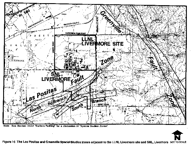
In California, many known active faults have been zoned in accordance with the Alquist-Priolo Special Studies Zone Act of 1972 (Hart, 1988). This legislation, which regulates development along faults, serves to prevent construction directly on fault traces that may be expected to rupture in the future. Portions of the Las Positas and Greenville faults are included in Special Studies Zones and shown in Figure I-5 (California Division of Mines and Geology, 1982). Due to the proximity of the Las Positas fault zone, a small portion of the southeast corner of the LLNL Livermore site is included in the Special Studies Zone for this fault. No fault strands were found in exploratory trenches across this small triangular parcel of approximately 1400 m2 (15,000 ft2) (Carpenter et al., 1984). The north branch of the Las Positas fault zone and its approximately 800-ft-wide Special Studies Zone crosses SNL, Livermore (Figure I-5) along the base of the prominent northeast-facing slope. Although the south branch of the fault does not transect the site, the southeastern corner of the SNL, Livermore site has been designated a Special Studies Zone (Figure I-5).
The potential for surface faulting does exist at SNL, Livermore. The areas adjacent to the active strand of the Las Positas fault would most likely experience ground deformation, associated with fault rupture. Due to the limited amount of subsurface information along the fault and the relatively wide zone of shears (50 to 100 m) associated with both strands of the Las Positas fault (Carpenter et al., 1984), unrecognized strands of the Las Positas fault may be present beneath the SNL, Livermore facilities. The north branch of the Las Positas fault runs along the north ends of buildings 970, 972, 973, and 976 (California Division of Mines and Geology, 1982). It is not clear whether the fault projects beneath the buildings or misses them completely. It is clear that buildings 970, 972, 973, and 976 are exposed to the greatest risk of surface faulting due to their proximity to the north branch of the Las Positas fault. Building 968 is also located within the Las Positas fault special studies zone, but is located further from the mapped fault (Blume and Associates, 1978; Herd, 1977) than Buildings 970, 972, 973, and 976. While Building 968 is exposed to a greater risk of damage due to surface faulting than other structures not within the special studies zone, its distance from the actual mapped fault indicates this risk is still small.
Faults which were previously inferred to cross or project toward the LLNL Livermore site (e.g., Tesla, Dougherty, and Ramp thrust faults) (Huey, 1948, 1972; Blume and Associates, 1972, 1978) are either truncated by the active Greenville and Las Positas faults or are no longer interpreted as faults. As reported in the DEIS for Decontamination and Waste Treatment Facility for the LLNL site (DOE, 1988) a crack in the pavement east of Building 618 was discovered in 1985. An investigation was unable to verify that the crack was or was not fault-induced (DOE, 1988). The possibility that an old, abandoned strand of the Greenville fault, located immediately southeast of the LLNL Livermore site between the active branches of the Las Positas fault zone (Carpenter et al., 1984) could be reactivated or triggered by coseismic slip on a nearby fault is possible, but highly unlikely. This possibility is remote due to: (1) the lack of geologic and geophysical evidence for any displacement in sediments 300,000 years and older (Carpenter et al., 1984); (2) the seismologic evidence for earthquake activity concentrated to the east along the modern Greenville fault (Bolt et al., 1981); and (3) the likely truncation of the fault by the north branch of the Las Positas fault. The inferred abandoned strand of the Greenville fault was not recognized by Herd (1977) and Dibblee (1980a); therefore, the potential for surface faulting within the LLNL Livermore site is insignificant.
Liquefaction
Liquefaction is a type of soil failure where a mass of saturated soil is transformed from a solid to a fluid state. Liquefaction of soils supporting foundations can lead to a loss of bearing capacity and excessive settlement of foundations. The liquefaction potential of a soil deposit is controlled by several factors such as the depth to ground water, the type and density of the soil, and the intensity and duration of ground shaking. Soils most susceptible to liquefaction are geologically young, saturated, uniformly graded sandy soils in a loose to medium-dense condition.
Alluvial deposits underlying the LLNL Livermore site and the adjacent SNL, Livermore do not possess the physical properties of materials generally subject to liquefaction (Carpenter et al., 1984). In addition, depths to ground water range from 13 m to about 49 m beneath the LLNL Livermore site and from 27 m to about 38 m beneath SNL, Livermore (Carpenter et al., 1984). No perched ground water bodies have been identified beneath the LLNL Livermore site. Based on fairly deep ground water levels, uniformly distributed, poorly sorted sediments beneath the sites, and a relatively high degree of sediment compaction or density, the potential for liquefaction at the LLNL Livermore site and SNL, Livermore is insignificant.
Seismically Induced Landslides
Landslide is a general term for a variety of processes and land forms resulting from the downslope movement, under gravity, of masses of soil and rock material. Types of landslides include translational and rotational block slides, slumps, rockfalls, mud flows, and debris flows. Earthquake ground motion is only one of several factors that contribute to the instability of a rock or soil mass.
The LLNL Livermore site consists of a relatively smooth land surface that slopes gently downward to the northwest. Elevations within the laboratory range from a low of 174 m at the northwest corner of the site to 206 m at the southeast corner (Carpenter et al., 1984). The total relief across the 1.9 km wide site is 32 m, and slopes onsite generally do not exceed 2· (Carpenter et al., 1984). Because of the very low relief at the site, the potential for slope instability at the LLNL Livermore site is insignificant.
SNL, Livermore consists of two different types of terrain separated by the north branch of the Las Positas fault. The area north of the fault consists of a relatively smooth land surface that gently slopes downward to the northwest. Elevations within the northern portion of the site range from a low of 195 m at the northwest corner to about 207 m adjacent to the Las Positas fault. The total relief across the northern portion of the site is approximately 12 m. The steepest slopes are along the banks of Arroyo Seco, which flows northward across the site. Due to the very low relief, the potential of slope instability on the northern portion of SNL, Livermore is insignificant.
The terrain south of the Las Positas fault consists of a portion of the foothills and is bounded to the south by the south branch of the Las Positas fault. The southern end of the SNL, Livermore site includes the crest of the foothills, which is 259 m, the highest elevation on the site. The relief between the fault and the ridge crest is 52 m over a distance of approximately 366 m. The slope of the northwest-facing flank of the foothills in the southern portion of the site is approximately 8·, with steeper slopes locally. Due to the slightly higher relief in the southern portion of the site and the soil types found there, the potential for slope instability at the southern portion of SNL, Livermore is sufficiently high to require consideration.
Table I-3 LLNL Livermore Site and SNL, Livermore Ground Motion Hazard Estimates, Design Criteria, and EIS/EIR Demand Criteria Expressed as Peak Horizontal Ground Acceleration (g)
| Source | Average Return Period (years) | ||
| 500 | 1000 | 5000 | |
| Ground Motion Hazard Estimates | |||
| TERA Corporation (1983) | 0.41 | 0.48 | 0.68 |
| Woodward-Clyde Consultants (1984) and Geomatrix Consultants (1985)a | 0.49 | 0.58 | 0.79 |
| Geomatrix Consultants (1990) | 0.57 | 0.68 | 0.98 |
| Geomatrix Consultants (1991) | 0.51 | 0.61 | 0.88 |
| Seismic Design Criteria | |||
| LLNL (1980–1989 ) Criteria (Freeland, 1984)b and (Tokarz, 1991a) | 0.25 | 0.25/0.5 | 0.5/0.8 |
| DOE Criteria (Kennedy et al., 1990) | 0.41 | 0.48 | 0.68 |
| LLNL Proposed Criteria (Coates, 1991) | 0.47 | 0.57 | 0.82 |
| Seismic Demand Criteria for 1991 EIS/EIRc | |||
| WESTON (1991a) | 0.5 | 0.6 | 0.8 |
a The 5000-year peak ground acceleration was reported in Geomatrix Consultants (1985).
b The values of 0.25g/0.5g, and 0.5g/0.8g
were required by the referenced criteria for all new designs and/or
modifications of General/Low Hazard, Moderate Hazard, and High Hazard
facilities, respectively. These values were not developed specifically to
reflect the 500-, 1000-, and 5000-year return periods.
c See section I.4.2.5 for description of
demand criteria.
Table I-4 Deterministic Estimates of Peak Horizontal Ground Accelerations for the LLNL Livermore Site for Maximum Credible Magnitude Earthquakes on the Greenville and Las Positas Faults
| Attenuation Relations | Peak Accelerations (g) | |||
| M = 6.6 on Greenville Fault at 1.5 km Distance | M = 6.0 on Las Positas Fault at 0.3 km Distance | |||
| mean | mean + s | mean | mean + s | |
| Joyner and Boore (1982)—random | 0.43 | 0.82 | 0.32 | 0.61 |
| Campbell (1989) | 0.49 | 0.75 | 0.45 | 0.69 |
| Crouse et al. (1987) | 0.50 | 0.89 | 0.51 | 0.91 |
| Idriss (1987) | 0.45 | 0.66 | 0.25 | 0.38 |
| Sadigh et al. (1986) | 0.49 | 0.69 | 0.35 | 0.53 |
| Average: | 0.47 | 0.76 | 0.38 | 0.62 |
Note: s indicates one standard deviation from the mean. Source: WESTON, 1991a.
Table I-5 Deterministic Estimates of Peak Horizontal Ground Accelerations at SNL, Livermore for Maximum Credible Magnitude Earthquakes on the Greenville and Las Positas Faults
| Attenuation Relations | Peak Accelerations (g) | |||
| M = 6.6 on Greenville Fault at 3.7 km Distance | M = 6.0 on Las Positas Fault at 0.1 km Distance | |||
| mean | mean + s | mean | mean + s | |
| Joyner and Boore (1982)—random | 0.40 | 0.76 | 0.32 | 0.61 |
| Campbell (1989) | 0.44 | 0.66 | 0.45 | 0.69 |
| Crouse et al. (1987) | 0.36 | 0.64 | 0.55 | 0.99 |
| Idriss (1987) | 0.39 | 0.57 | 0.25 | 0.38 |
| Sadigh (1987) | 0.41 | 0.58 | 0.35 | 0.53 |
| Average: | 0.40 | 0.64 | 0.38 | 0.64 |
Note: s indicates one standard deviation from the mean. Source: WESTON, 1991a.
I.4.2.5 Demand Criteria for EIS/EIR
Based on the previous analyses as discussed in section I.4.2.4, values for maximum ground acceleration at the LLNL Livermore and SNL, Livermore sites for return periods of 500, 1000, and 5000 years are 0.5g, 0.6g and 0.8g, respectively. These values are listed in Table I-3 where they can be compared with the results of previous ground motion hazard studies, as well as seismic design criteria for Laboratory facilities. These acceleration values are considered reasonable and appropriate and are close to the mean peak estimates in the Woodward-Clyde (1984) study and the mean effective estimates in the Geomatrix (1991) study. These values are also supported by a simplified probabilistic seismic hazard analysis (WESTON, 1991a). The differences in predicted values of acceleration from the first four studies (TERA Corporation, 1983; Woodward-Clyde, 1984; Geomatrix 1985, 1990) are primarily due to differences in attenuation relations, computational methods incorporating varying degrees of conservatism, and the earthquake source characterizations used in the analyses.
In an earthquake, in the vicinity of the causative fault, the "instrumental peak" ground acceleration motion is generally greater than the smaller motions that occur many times during an earthquake. These smaller motions are considered the "effective" values. They are calculated by averaging the several largest instrumental peak accelerations. The Geomatrix Consultants (1991) values reported in Table I-3 are effective accelerations, conservatively shown using a ratio of effective acceleration divided by instrumental peak acceleration (Aeff/Apeak) equal to 0.9. Geomatrix Consultants (1991) provides additional guidance for utilizing lower Aeff/Apeak ratios which would result in lower acceleration values than those shown in Table I-3. The values proposed in Coates (1991) are based on the studies by Geomatrix Consultants (1990, 1991). However, Coates (1991) provides the technical basis for selecting the lower ratios of Aeff/Apeak actually reported in Geomatrix Consultants (1991). Another example of the use of the effective peak ground acceleration values is given in the Geological Survey Circular No. 672 (Page et al., 1972), which reported values for near-fault (3 to 5 km) horizontal ground accelerations to be used in evaluating the Trans-Alaskan Pipeline System. For local magnitude 7 earthquakes, the average of the 5 largest instrumental acceleration peaks expressed as a ratio to the peak instrumental acceleration (Aeff/Apeak) is 0.83. The corresponding ratio (Aeff/Apeak) for the 10 largest acceleration peaks is 0.71.
The use of effective peak ground accelerations instead of instrumental peak ground accelerations reflects the generally accepted understanding of how earthquake motions damage structures and equipment. Typical structures and equipment such as those found at LLNL and SNL, Livermore are more susceptible to damage from multiple cycles of lower level ground accelerations than they are to a single peak acceleration "shock" which is not repeated. The accelerations presented in Table I-3 as the demand criteria for the 1991 EIS/EIR have the same values as the instrumental peak accelerations presented in Geomatrix Consultant (1991) multiplied by an Aeff/Apeak ratio of 0.83, and rounded to a single significant digit. Tokarz (1991b) and Coates (1991) report that the LLNL Livermore site will be officially adopting the values of 0.47g, 0.57g, and 0.82g peak ground accelerations for the 500-, 1000-, and 5000-year return intervals, respectively.
More complete estimates of the seismic ground motion hazard are provided by acceleration response spectra, and effective peak ground acceleration values are key starting point inputs to the development of such spectra. Acceleration response spectra are considered to be primary elements of a seismic demand criteria because it is from them that seismic forces postulated to act on structures are calculated.
Based on the seismicity parameters used by Woodward-Clyde Consultants (1984), Geomatrix Consultants (1985) developed equal-hazard response spectra for the LLNL Livermore site and updated these spectra in Geomatrix Consultants (1990, 1991) using more recent spectral ordinate attenuation relationships. Equal-hazard response spectra were derived for return periods of 100, 500, 1000, and 5000 years.
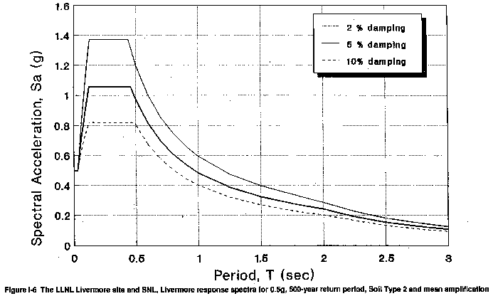
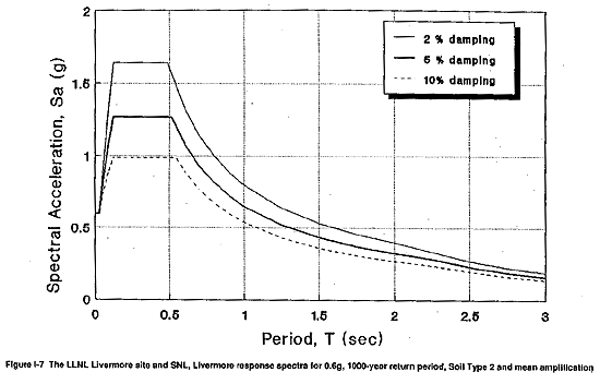
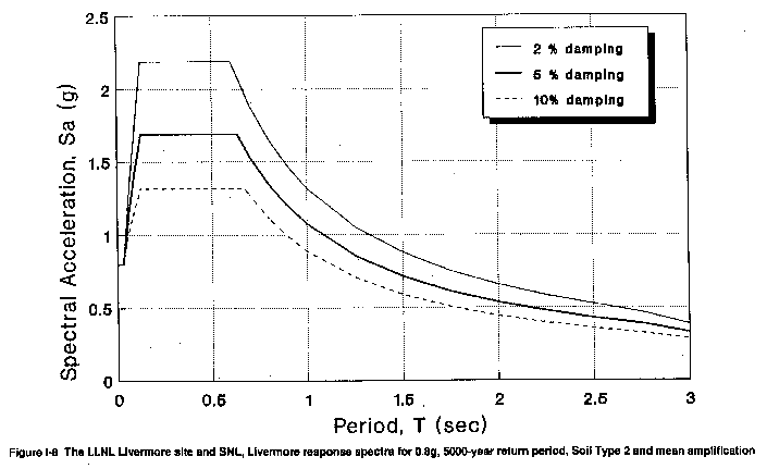
The mean acceleration response spectra developed in WESTON (1991a) were calculated following the procedures in Newmark and Hall (1982) for Soil Type 2 (see Newmark and Hall, 1982, for a detailed discussion of soil types). These spectra are shown in Figure I-6, Figure I-7, Figure I-8, and Figure I-9 for effective peak ground accelerations of 0.5g, 0.6g, 0.8g, and 0.9g and for critical damping values of 2 percent, 5 percent, and 10 percent. Figure I-9 with an effective peak ground acceleration of 0.9g corresponds to the Above Design Basis seismic event described in sections I.4.1 and I.4.2.4. Mean spectral amplification curves were provided, recognizing that the most recent guidelines for seismic design and evaluation of DOE facilities (Kennedy et al., 1990) recommend the use of mean amplification spectra (no conservative bias).
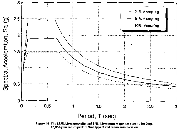
As discussed in sections I.4.1 and I.5, only the spectra corresponding to earthquakes with effective peak ground accelerations of 0.8g and 0.9g were used in the building assessments reported in section I.8. The spectra corresponding to lower peak ground accelerations are shown to demonstrate the degree of extra conservatism associated with the low and moderate hazard building assessment results presented in section I.8.
I.4.3 Seismicity of LLNL Site 300
I.4.3.1 Seismotectonic Setting
LLNL Site 300 is located on the eastern side of the Altamont Hills, between Livermore and San Joaquin valleys, near the eastern margin of the Diablo Range in the Coast Range province (see Figure I-2). It is located east of the transform plate margin of the North American and Pacific plates. At the latitude of LLNL Site 300, faults of the San Andreas system include, from west to east, the San Gregorio, San Andreas, Hayward, Calaveras, and Greenville faults (Figure I-2). LLNL Site 300, underlain by Tertiary marine and nonmarine sedimentary rocks, and locally Quaternary terrace deposits, is bounded by the Tesla fault system to the south and the Midway and Black Butte faults to the east (Figure I-2 and Figure I-3).
The boundary between the Coast Ranges and Sierran block lies approximately 3 km east of LLNL Site 300 (Figure I-2) and is characterized by east-northeast directed compression, resulting in reverse and thrust faulting (Wong et al., 1988; Wentworth and Zoback, 1989).
Seismicity along the Coast Range–Sierran block transition at the latitude of LLNL Site 300 is spatially diffuse and episodic, with shallow earthquakes (Wong et al., 1988). The seismogenic sources are generally west-dipping high-angle faults, although north-trending right-slip faults are also present. To the south, earthquake focal mechanisms indicate northeast-east compression, normal to the Coast Range–Sierran block boundary (Wong et al., 1988). Large earthquakes, such as the 1983 Coalinga earthquake (ML 6.7) and the previously discussed 1892 Winters earthquakes (ML 6), characterize the boundary; thus, the potential exists for large earthquakes along the 600-km margin of the San Joaquin and Sacramento valleys.
I.4.3.2 Historical Seismicity
Preinstrumental
For a discussion of preinstrumental seismicity relative to LLNL Site 300, see section I.4.2.2.
Instrumental
The local seismicity in the Altamont Hills surrounding LLNL Site 300 is characterized as diffuse and of a low level (Carpenter et al., 1991). Most earthquakes recorded since 1969 are smaller than magnitude 2.0 and have occurred at depths less than 10 km (Wong et al., 1988). Although Wong et al. (1988) plotted earthquakes on or adjacent to the Black Butte, Midway, and Tesla faults, suggesting recent activity, there are 5–10 km of uncertainty associated with the location of earthquake epicenters within the Altamont Hills. The Corral Hollow–Carnegie fault zone, which traverses the southwest portion of LLNL Site 300, has no visible expression in the seismicity data (Carpenter et al., 1991). No large earthquakes have been recorded on the Corral Hollow–Carnegie, Black Butte, Midway, and Tesla fault zones, which are discussed further in section I.4.3.3.
For a discussion of the regional instrumental seismicity, see section I.4.2.2.
I.4.3.3 Seismic Sources
The three principal strands of the San Andreas fault system, the San Andreas, Hayward, and Calaveras faults, have produced the majority of significant historical earthquakes in the Bay Area. The San Andreas and Hayward faults are discussed as the seismic sources for the LLNL Livermore site and SNL, Livermore in section I.4.2; however, it is the local faults in the region that contribute the majority of the seismic hazard to LLNL Site 300 (Figure I-4). The largest contribution to the ground shaking hazard at LLNL Site 300 may be produced by moderate earthquakes on the Greenville, Las Positas, Corral Hollow–Carnegie, Midway, and Black Butte faults. The Greenville and Las Positas faults are discussed in section I.4.2.3. Larger earthquakes on more distant faults do not significantly affect the hazard estimates.
In addition to the Corral Hollow–Carnegie fault zone, numerous other faults have been mapped at LLNL Site 300 (Figure I-10). Most of these faults are relatively short in length and apparently have only minor separation within the Miocene and Pliocene bedrock. The faults can be grouped into four geographic areas within the site: (1) northwest-trending, en echelon, high-angle strike-slip and reverse faults along Elk Ravine; (2) north-northeast-trending, high-angle faults that truncate the Elk Ravine Fault in the eastern part of the site; (3) northeast- and east-trending reverse faults in the southern and central portions of the site; and (4) northwest-trending, high-angle faults that are truncated by the Carnegie fault. The youngest rocks offset by these aforementioned faults are Pliocene in age. Based on the lack of geomorphic expression, age of the youngest offset strata, and cross-cutting relationships, the faults are likely pre-Holocene in age.
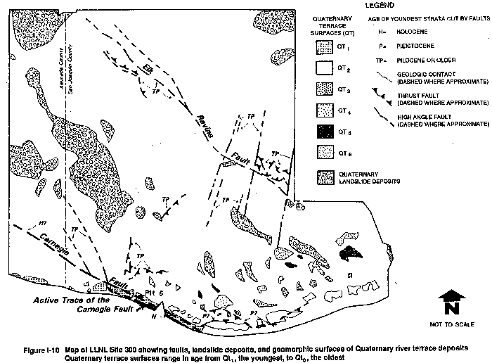
Corral Hollow–Carnegie Fault
The northwest-trending Corral Hollow–Carnegie fault zone is located along the southern portion of LLNL Site 300 (Figure I-4 and Figure I-10). The Corral Hollow–Carnegie fault zone is approximately 29 km long (Figure I-4) and is mostly buried beneath present-day alluvial cover along Corral Hollow Creek. The Carnegie fault strand branches from the Corral Hollow fault in Corral Hollow Creek immediately south of LLNL Site 300 and merges back into the Corral Hollow fault approximately 7 km to the northwest (Dibblee, 1980d). The fault zone is subparallel to the Greenville fault to the north and merges with the Tesla fault to the south (Figure I-4) and probably transfers slip between the Tesla-Ortigalita fault system and the Greenville fault (Herd, 1977; Dibblee, 1980a, 1980d).
Recent geologic studies along the Corral Hollow–Carnegie fault zone at LLNL Site 300 have demonstrated Holocene activity (Carpenter et al., 1991). A previously unrecognized strand of the fault, exposed 60 to 75 m south of the Carnegie Fault, as mapped by Dibblee (1980d), displaces late Pleistocene terrace deposits and Holocene colluvium (Figure I-10; Dugan et al., 1991). These offset terrace gravels are the youngest of a flight of Quaternary river terraces that are present along Corral Hollow in the southern part of LLNL Site 300 (Figure I-10).
The zone of active faulting is approximately 3 to 4 m wide. A thrust fault and a high-angle fault, exposed just to the north of the Holocene fault, cut Lower Tertiary rocks of the Tesla Formation. The thrust fault offsets a shear that displaces Holocene sediments approximately 54 cm, which demonstrates Holocene thrust faulting (Carpenter et al., 1991). Several springs and seeps align along the northwest-trending active strand. Based on a limited number of slickenside striae and a large scatter in the data set, Carpenter et al. (1991) estimated an average plunge of 30· for the slickensides, suggesting an average horizontal to vertical displacement ratio of 2:1. Using this ratio, it is estimated that a late Pleistocene erosion surface near Pit 6 (Figure I-10) is offset horizontally by 3.75 m (Carpenter et al, 1991). Minor thrust faults, that apparently deform Pleistocene river terrace deposits, have been identified immediately north of the Corral Hollow–Carnegie fault zone (Figure I-10; Dugan et al., 1991).
Slip rates for the Corral Hollow–Carnegie fault system are based on right-lateral offsets of Late Tertiary erosion surfaces and Holocene colluvial horizons. An older strand of the Corral Hollow–Carnegie fault offsets a Plio-Pleistocene syncline approximately 3 km (Dibblee, 1980a). Based on the offset syncline, an estimated slip rate for the fault is 0.13 mm/yr (Sweeney, 1982). The estimated slip rate for the Holocene strand ranges from 0.06 to 2 mm/yr (Carpenter et al., 1991). The broad range of Holocene slip rates are due to the absence of piercing points along the fault and large uncertainties in the ages of the offset sediments.
Midway Fault
The northwest-trending, right-lateral Midway fault is located approximately 1 km north of LLNL Site 300 (Figure I-4; Dibblee, 1980d). The fault has a strike length of approximately 10 km and locally juxtaposes Plio-Pleistocene sediments against Miocene deposits. The Midway fault lies to the east and parallel to the Greenville fault system. Based on regional correlations, Clark et al. (1984) interpret the Midway fault as a moderately dipping reverse fault; however, based on the straight, linear fault trace and seismic focal mechanisms, the Midway fault is a near-vertical feature, with predominantly right-lateral strike slip separation, east-side up. This fault is considered potentially active.
Black Butte Fault
The northwest-trending Black Butte fault is exposed along the eastern flank of the Diablo Range, approximately 2.5 km east-southeast of LLNL Site 300 (Figure I-3 and Figure I-4; Dibblee 1980a, 1980d, 1981b). This fault is considered potentially active and is discussed in more detail in section I.4.2.3.
Tesla Fault
The north-northwest-trending Tesla fault, located 1.5 km southwest of LLNL Site 300 (Figure I-4), is truncated by the Greenville fault to the northeast and continues to the southeast along the east side of the Diablo Range (Figure I-4). It is discussed in more detail in section I.4.2.3.
I.4.3.4 Seismic Hazards
Ground Motion
The region surrounding LLNL Site 300 has experienced strong ground shaking during historic earthquakes. In 1906 the great San Francisco earthquake (magnitude 8+) on the San Andreas fault produced structural damage a few kilometers west of LLNL Site 300. Damage included a large brick smokestack which collapsed on a pottery works and a fallen water tank (Nason, 1982).
Potential sources of future ground motion at LLNL Site 300 include the major regional fault zones such as the San Andreas, Hayward, and Calaveras, as well as smaller faults including the Greenville and Las Positas. The faults nearest LLNL Site 300, the Corral Hollow–Carnegie, Black Butte, and Midway faults (Figure I-4), represent the greatest hazard to the site.
Only one probabilistic seismic hazard analysis has been conducted for LLNL Site 300. This study, performed by TERA Corporation (1983), generated hazard curves, which express results in terms of peak horizontal ground acceleration versus return period, for two locations within LLNL Site 300. The two locations were Complex 854 near the western boundary of the site and Complexes 834 and 836 near the eastern boundary, selected because of the dominant importance of these two complexes to the operation of LLNL Site 300. Peak ground accelerations corresponding to return periods of 500, 1000, and 5000 years were estimated as 0.32, 0.38, and 0.56g for Complex 854; and 0.28, 0.34, and 0.51g for Complexes 834 and 836 (TERA Corporation, 1983). These return periods correspond to the levels of risk specified in the LLNL seismic design criteria for low, moderate, and high hazard facilities (Freeland, 1984).
A deterministic approach, which is based on estimating the largest earthquakes that might occur on local faults, is useful to provide a comparison with values estimated from the probabilistic seismic hazard analyses. This comparison is used to check that the probabilistic hazard analyses have adequately accounted for maximum magnitude earthquakes that could reasonably occur in the vicinity of the site. The Carnegie fault, which traverses the southwest portion of the site, has recently been shown to offset likely Holocene colluvium and is therefore considered active (Carpenter et al., 1991). The Black Butte and Midway faults displace Pleistocene materials and are considered potentially active. No significant earthquakes have occurred on any of these three faults during historic time.
Given a recent study of Holocene faulting at LLNL Site 300, maximum earthquake magnitude (MS) estimates based on fault length, for the Corral Hollow–Carnegie fault zone were estimated from 6.3 to 7.1 with an average of 6.5 (Carpenter et al., 1991). For the 15-km-long Black Butte fault, maximum surface wave magnitude estimates range from 6.5 to 6.8 with an average of 6.6 using various empirical equations relating fault length to maximum magnitude (Bonilla et al., 1984; Slemmons, 1982; Wyss, 1979). An average maximum magnitude of 6.4 was obtained from a range of 6.1 to 6.9 for the 10-km-long Midway fault (Bonilla et al., 1984; Slemmons, 1982; Wyss, 1979). These average maximum magnitudes were then used in the deterministic hazard analysis of Complex 854 and Complexes 834 and 836. A comparison of the peak horizontal ground accelerations generated from the three aforementioned earthquakes are presented in Table I-6 and Table I-7 for both complexes at LLNL Site 300. For Complex 854, a MS 6.5 earthquake on the Corral Hollow–Carnegie fault produces the greatest accelerations (Table I-6), whereas a MS 6.6 earthquake on the Black Butte fault generates the maximum accelerations for Complexes 834 and 836 (Table I-7). Considering a MS 6.5 earthquake on the Corral Hollow–Carnegie fault at a distance of 1.4 km from Complex 854, the mean peak ground accelerations could range from 0.41 to 0.65g with an average of 0.53g (Table I-6). The mean + s (where s is one standard deviation from mean) values for the same attenuation relations range from 0.74 to 0.92g, with an average of 0.82g (Table I-6).
Given a MS 6.6 earthquake on the Black Butte fault at a distance of 2.4 km from Complexes 834 and 836, the mean peak ground accelerations could range from 0.42 to 0.71g with an average of 0.59g. The mean + s values for the same attenuation relations range from 0.76 to 1.06g, with an average of 0.91g (Table I-7).
In addition to the above three local seismic sources, there is the possibility that a buried or blind thrust fault may produce strong ground motions at LLNL Site 300. Recent studies have inferred that the entire boundary between the Coast Ranges and Sierran block (San Joaquin Valley) is characterized by east-northeast directed compression and thrust faulting similar to that which occurred in the 1983 Coalinga earthquake (Wong et al., 1988; Wentworth and Zoback, 1989). Blind-thrust faults have recently been found several kilometers to the north along the southwestern margin of the Sacramento Valley (Unruh et al., 1991; Phipps et al., 1991). Although no similar structures are known to exist beneath the Altamont Hills where LLNL Site 300 is located, a comprehensive evaluation of the potential for these buried structures needs to be undertaken, as they could significantly add to the hazard at LLNL Site 300. This uncertainty is considered when establishing the demand criteria for LLNL Site 300, which is discussed in section I.4.3.5.
Surface Faulting
There have been no historical occurrences of surface faulting in the vicinity of LLNL Site 300. The nearest documented occurrences of surface faulting were in the Livermore Valley region. The July 3, 1861 earthquake (estimated ML 6.0) caused surface faulting along the Calaveras fault in the westernmost Livermore (Amador) and San Ramon valleys (Radbruch, 1968). More recently, the January 24 and 27, 1980 Livermore earthquakes (ML 5.5 and 5.6) centered on the Greenville fault, produced minor amounts of displacement on the Greenville fault and may have also been responsible for producing minor aseismic slip along the Las Positas fault (Bonilla et al., 1980).
The potential for surface faulting does exist at LLNL Site 300. The areas adjacent to the active strand of the Carnegie fault would most likely experience ground deformation, associated with fault rupture, should an earthquake occur on the fault. A 3- to 4-m-wide zone of faulting is present in Holocene and late Pleistocene deposits along the Carnegie fault, attesting to the potential for surface rupture. Due to the limited amount of subsurface information along the fault, unrecognized strands of the Carnegie fault may be present beneath LLNL Site 300. However, any such strands are likely to be limited to the area south of the Carnegie fault which forms a well-defined bedrock discontinuity.
In addition to the principal Holocene strike-slip Carnegie fault strand located south of Pit 6, there are two subsidiary reverse faults that could potentially produce minor amounts of surface rupture (Dugan et al., 1991). These subparallel strands that extend east of Pit 6 may represent a partitioning of the compressional component of slip within the Corral Hollow–Carnegie fault zone.
The only structures located adjacent to the Holocene strand of the Carnegie fault, and therefore subject to the hazard of surface faulting, are Buildings 899A and 899B at the pistol range. However, these two structures contain no hazardous or radiological materials.
Liquefaction
LLNL Site 300 is underlain mostly by Tertiary bedrock, which does not possess the physical properties of materials generally subject to liquefaction. There are no perennial streams in the site, and except for a few isolated springs and seeps, soils beneath river channels are unsaturated (Raber and Carpenter, 1983). Quaternary alluvial deposits are not saturated, except locally at Pit 6 (Figure I-10), where ground water is present in Pleistocene gravel-bearing terrace deposits (Raber and Carpenter, 1983). These terrace deposits are not considered susceptible to liquefaction (Helley et al., 1979). Based on the presence of bedrock beneath LLNL Site 300 and the relatively high degree of compaction or density of the terrace deposits, the potential for liquefaction at LLNL Site 300 is insignificant.
Seismically Induced Landslides
LLNL Site 300 has moderate relief, with elevations ranging from about 152 m along Corral Hollow Creek to approximately 489 m in the northwest portion of the site. Slopes are generally moderate, with local steeper slopes up to approximately 25·. There are numerous landslides located at LLNL Site 300 with the largest landslide covering approximately 1.4 km2 (Figure I-10). The Miocene Cierbo Formation, consisting of sandstone, shale, and tuff, appears to be the geologic unit most susceptible to landsliding at LLNL Site 300. In addition, landslides appear to be most prevalent on northeast-facing slopes, perhaps due to localized increase of water retention and associated stream incision in the hillslope.
Due to the moderate relief and the presence of ancient landslide deposits, the potential for seismically induced slope instability at LLNL Site 300 is considered moderate. Furthermore, the potential for slope instability would be greater on northeast-facing slopes that have strata of the Cierbo Formation exposed. Buildings 825, M825, 826, M51, 857, 851A, 851B, 854, 855, and 856 are located on old landslides. The potential for future ground deformation at the above buildings located on landslide deposits is sufficiently high to require consideration.
Table I-6 Deterministic Estimates of Peak Horizontal Ground Accelerations at LLNL Site 300-Complex 854 for Maximum Credible Magnitude Earthquakes on the Corral Hollow-Carnegie, Black Butte, and Midway Faults
| Attenuation Relations | Peak Accelerations (g) | |||||
| M = 6.5 on Corral Hollow–Carnegie Fault at 1.4 km Distance | M = 6.6 on Black Butte Fault at 5.7 km Distance | M = 6.4 on Midway Fault at 4.5 km Distance | ||||
| mean | mean + s | mean | mean + s | mean | mean + s | |
| Joyner and Boore (1982)—random | 0.41 | 0.78 | 0.35 | 0.67 | 0.34 | 0.65 |
| Campbell (1989) | 0.49 | 0.74 | 0.55 | 0.84 | 0.39 | 0.59 |
| Idriss (1987) | 0.57 | 0.83 | 0.40 | 0.59 | 0.44 | 0.65 |
| Sadigh (1987) | 0.65 | 0.92 | 0.54 | 0.76 | 0.47 | 0.67 |
| Average: | 0.53 | 0.82 | 0.46 | 0.72 | 0.41 | 0.64 |
Note: s indicates one standard deviation from the mean. Source: WESTON, 1991a.
Table I-7 Deterministic Estimates of Peak Horizontal Ground Accelerations at LLNL Site 300-Complexes 834 and 836 for Maximum Credible Magnitude Earthquakes on the Corral Hollow-Carnegie, Black Butte, and Midway Faults
| Attenuation Relations | Peak Accelerations (g) | |||||
| M = 6.5 on Corral Hollow–Carnegie Fault at 3.0 km Distance | M = 6.6 on Black Butte Fault at 2.4 km Distance | M = 6.4 on Midway Fault at 5.8 km Distance | ||||
| mean | mean + s | mean | mean + s | mean | mean + s | |
| Joyner and Boore (1982)—random | 0.39 | 0.74 | 0.42 | 0.80 | 0.32 | 0.60 |
| Campbell (1989) | 0.45 | 0.68 | 0.69 | 1.06 | 0.35 | 0.54 |
| Idriss (1987) | 0.50 | 0.73 | 0.52 | 0.76 | 0.40 | 0.59 |
| Sadigh (1987) | 0.55 | 0.79 | 0.71 | 1.01 | 0.41 | 0.60 |
| Average: | 0.47 | 0.74 | 0.59 | 0.91 | 0.37 | 0.58 |
Note: s indicates one standard deviation from the mean. Source: WESTON, 1991a.
I.4.3.5 Demand Criteria for EIS/EIR
Based on the previous analyses as discussed in section I.4.3.4, values for maximum ground acceleration at both complexes at LLNL Site 300 (854 and 834/836) for return periods of 500, 1000, and 5000 years are 0.5g, 0.6g and 0.8g, respectively. These values are listed in Table I-8 where they can be compared with the results of the previous ground motion hazard study, as well as the present DOE criteria and the LLNL criteria for LLNL Site 300.
These values, which are the same values used as the EIS/EIR demand criteria for the LLNL Livermore site and SNL, Livermore, are more conservative than those estimated in the TERA Corporation (1983) study. Although the 0.5, 0.6, and 0.8g values are not site-specific to LLNL Site 300, they are more appropriate for use because the TERA values probably underestimate the seismic hazard at LLNL Site 300 for the following reasons: (1) recent studies by Woodward-Clyde Consultants (1984) and Geomatrix Consultants (1990) have estimated greater values for peak ground acceleration at the LLNL Livermore site than did the 1983 TERA Corporation study of the LLNL Livermore site (Table I-3 in section I.4.2). In addition, Geomatrix Consultants (1985) compared the 1983 TERA Corporation and 1984 Woodward-Clyde Consultants seismic hazard studies and concluded that the differences between the two studies were due primarily to the use of different attenuation relations. TERA Corporation (1983) used the same attenuation relation and modeling techniques for their LLNL Livermore site analysis and for their LLNL Site 300 analysis; (2) the seismic sources in the vicinity of LLNL Site 300 are poorly understood and may not be properly characterized in the analysis; and (3) the potential for blind-thrust faults in the vicinity of LLNL Site 300 presents the possibility that an additional seismic source is unaccounted for in past evaluations. Therefore, in the absence of any additional seismic hazard studies, the peak ground acceleration values of 0.5, 0.6, and 0.8g are considered to be appropriate for use at LLNL Site 300.
As discussed previously, more complete estimates of the seismic ground motion hazard are provided by acceleration response spectra, and peak ground acceleration values are key starting point inputs to the development of such spectra. Acceleration response spectra are considered to be primary elements of a seismic demand criteria because it is from them that seismic forces postulated to act on structures are calculated.
The mean acceleration response spectra developed in WESTON (1991a) were calculated following the procedures in Newmark and Hall (1982) for soil Type 1 (see Newmark and Hall, 1982, for a detailed discussion of soil types). These spectra are shown in Figure I-11 to Figure I-13 for peak ground accelerations of 0.5g, 0.6g, and 0.8g and for critical damping values of 2 percent, 5 percent, and 10 percent.
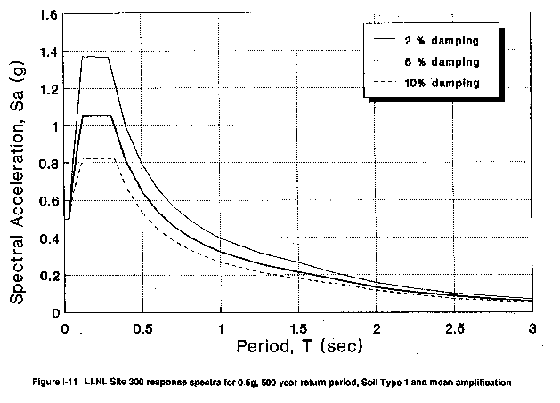
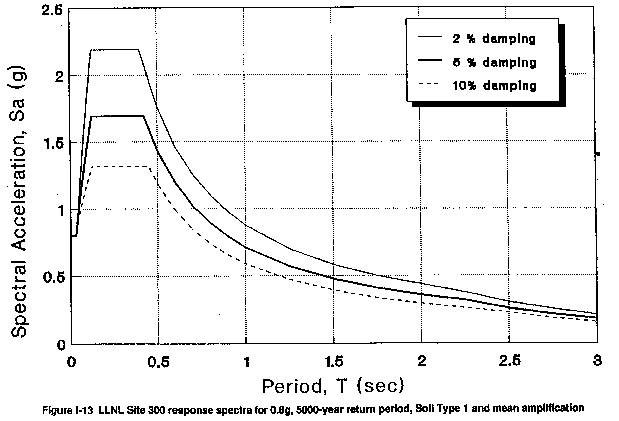
Table I-8 LLNL Site 300 Ground Motion Hazard Estimates, Design Criteria, and EIS/EIR Demand Criteria Expressed as Peak Horizontal Ground Acceleration (g)
| Source | Complex 854 | Complex 834/836 | ||||
| Average Return Period (years) | ||||||
| 500 | 1000 | 5000 | 500 | 1000 | 5000 | |
| Ground Motion Hazard Estimates | ||||||
| TERA Corporation (1983) | 0.32 | 0.38 | 0.56 | 0.28 | 0.34 | 0.51 |
| Seismic Design Criteria | ||||||
| DOE (Kennedy et al., 1990) | 0.32 | 0.38 | 0.56 | 0.28 | 0.34 | 0.51 |
| LLNL (1980–1989) Criteriaa,b | 0.25 | 0.25/0.5 | 0.5/0.8 | 0.25 | 0.25/5 | 0.5/0.8 |
| Seismic Demand Criteria for 1991 EIS/EIR | ||||||
| WESTON (1991a) | 0.5 | 0.6 | 0.8 | 0.5 | 0.6 | 0.8 |
a The values of 0.25g, 0.25g/0.5g, and
0.5g/0.8g were required by the referenced criteria for all new designs and/or
modifications of General/Low Hazard, Moderate Hazard, and High Hazard
facilities, respectively. These values were not developed specifically to
reflect the 500-, 1000-, and 5000-year return periods.
b From Freeland (1984) and Tokarz (1991a).
No specific statement in these criteria requires their use at LLNL Site 300.
Knowledgeable lab personnel (F. Tokarz and G. Freeland) state that these
criteria were applied to LLNL Site 300.
I.5 EVALUATION CRITERIA
Criteria contained within the 1990 DOE document Design and Evaluation Guidelines for DOE Facilities Subjected to Natural Phenomena Hazards - UCRL 15910 (Kennedy et al., 1990) are used to evaluate potentials for structure and equipment damage. These guidelines recommend that performance goals be used for the design of each usage category of structure. Table I-9 provides a description of these usage categories. Table I-10 provides the recommended performance goals for each usage category, as well as recommended annual exceedence probabilities of these performance goals. Table I-11 shows that if a structure receives a facility categorization of low, moderate, or high hazard under DOE Order 5481.1B "Safety Analysis Report System," its categorization is consistent with the usage category descriptions under UCRL 15910 (Kennedy et al., 1990) design guidelines. A 10-5 annual exceedence probability for the high hazard structure's performance goal indicates that there should only be a one in one-hundred thousand chance in any given year that the structure is damaged to the extent that loss of hazardous and/or radiological material confinement is possible. The performance goal of 10-5 annual exceedence probability for a high hazard structure is obtained by postulating a mean level seismic hazard event with a 2×10⁻⁴ annual exceedence probability, and evaluating the structures with design procedures that have no greater than a one in twenty chance of overestimating the actual structure's physical strength properties. This relationship can be expressed mathematically as follows:
If A = Annual Exceedence Probability of a Performance Goal
B = Annual
Exceedence Probability of the Seismic Event
C = Exceedence Probability of
Strength Properties in Design Procedures
Then A = (B) × (C)
For a High Hazard structure, this becomes;
10-5= (2 × 10-4) × (1/20)
As a comparison, UCRL-15910 (Kennedy et al., 1990) reports that the Department of Defense (DOD) tri-services seismic design provisions for Essential Buildings recommended a performance goal of 10-3 annual exceedence probability. As shown in Table I-11, a building classified as Essential under the DOD Tri-Service Manual corresponds to a high hazard structure under UCRL-15910 (Kennedy et al., 1990) or DOE Order 5481.1B.
The evaluation criteria in UCRL-15910 (Kennedy et al., 1990) allows the evaluation of low or moderate hazard structures using lower magnitude earthquakes than would be used to evaluate high hazard structures. It is partly this use of differing magnitude earthquakes, corresponding to different probabilities of their occurrence, that results in achieving the different performance goals discussed above in this section. However, as described in section I.4.1, only the seismic events corresponding to 5000 and 10,000 year return-intervals were used in making the seismic building assessments reported in section I.8. Except for this, all other parts of the evaluation criteria in UCRL-15910 (Kennedy et al., 1990) were used in the assessments.
Table I-9 Usage Category Guidelines
| Usage Category | Description |
| General Use Facilities | Facilities that have a non–mission-dependent purpose, such as administration buildings, cafeterias, storage, maintenance, and repair facilities that are plant- or grounds-oriented. |
| Important or Low Hazard Facilities | Facilities that have mission-dependent use (e.g., laboratories, production facilities, and computer centers) and emergency handling or hazard recovery facilities (e.g., hospitals, fire stations). |
| Moderate Hazard Facilities | Facilities where confinement of contents is necessary for public or employee protection. Examples would be uranium enrichment plants, or other facilities involving the handling or storage of significant quantities of radioactive or toxic materials. |
| High Hazard Facilities | Facilities where confinement of contents and public and environment protection are of paramount importance (e.g., facilities handling substantial quantities of in-process plutonium or fuel reprocessing facilities). Facilities in this category represent hazards with potential long-term and widespread effects. |
Source: Kennedy et al., 1990.
Table I-10 Performance Goals for Each Usage Category
| Usage Category | Performance Goal Description | Performance Goal Annual Probability of Exceedence* |
| General Use | Maintain occupant safety | 10-3 of the onset of major structural damage to the extent that occupants are endangered |
| Important or Low Hazard | Occupant safety, continued operation with minimal interruption | 5x10⁻⁴ of facility damage to the extent that the facility cannot perform its function |
| Moderate Hazard | Occupant safety, continued function, hazard confinement | 10-4 of facility damage to the extent that the facility cannot perform its function |
| High Hazard | Occupant safety, continued function, very high confidence of hazard confinement | 10-5 of facility damage to the extent that the facility cannot perform its function |
* A 10-3 annual probability of exceedence of the performance goal for a General Use facility indicates that there should be only a one-in-one-thousand chance in any given year that occupant safety would not be maintained.
Source: Kennedy et al., 1990.
Table I-11 Comparison of Usage Categories from Various Sources
| Source | Facility Categorization | |||
| UCRL-15910—DOE Natural Phenomena Hazard Guidelines | General Use | Important or Low Hazard | Moderate Hazard | High Hazard |
| 1988 Uniform Building Code | General Facilities | Essential Facilities | --- | --- |
| DOD Tri-Service Manual for Seismic Design of Essential Buildings | --- | --- | High Risk | Essential |
| IAEA-TECDOC-348—Nuclear Facilities with Limited Radioactive Inventory | --- | Class C | Class B | Class A |
| DOE 5481.1B SAR System | --- | Low Hazard | Moderate Hazard | High Hazard |
| NFPA 13 (Classifications for Sprinkler Systems) | Light Hazard | Ordinary Hazard
(Group 1) |
Ordinary Hazard
(Group 3) |
Extra Hazard |
| Nuclear Regulatory Commission | --- | --- | --- | ---* |
* NRC licensed commercial nuclear power plants have slightly more
conservative criteria than the criteria recommended for High Hazard facilities
by these guidelines.
--- = Document does not address this kind of facility.
Source:
Kennedy et al., 1990.
I.6 EVALUATION METHODOLOGY
Many of the structures identified as discussed in section I.3 had previously been designed using static Uniform Building Code type evaluations without accounting for the dynamic characteristics of their seismic force–resisting systems. The newer criteria (Kennedy et al., 1990) for moderate and high hazard structures requires that seismic forces be calculated by dynamic response spectra analyses, and that the capacity of seismic force resisting systems be calculated by inelastic methods. The latter methods, described in more detail in section I.7.1, are more rigorous than the static, elastic Uniform Building Code calculations.
The basic methodology used for this EIS/EIR evaluation was to extrapolate from results of existing seismic documentation to estimate what the probable result would be if existing facilities were evaluated against the selected probabilistic criteria. Once a building's design (or reevaluation) calculations were obtained, the first step of this extrapolation process was to identify from those existing calculations what constitutes the lateral and vertical seismic force resisting systems of the structure. These systems may be very different for different structures. One structure may resist seismic forces using reinforced concrete shear walls (such as the plutonium facility, Building 332), while another may use a welded steel frame (such as the medical facility, Building 663). Due to modifications or additions (sometimes referred to as increments) to structures over the years, some structures will have different lateral force resisting systems in different increments of the same structure. Typically, these increments are slightly separated from the original building or other increments by gaps, usually no more than 6 inches. These gaps are required (unless the lack of gaps is accounted for in the structural design calculations), because the different increments, having different force resisting systems, would vibrate differently in an earthquake. Without the presence of gaps, the different increments could pound together, further amplifying the loading on adjacent increments. If all increments of the structure might contain the identified hazardous and/or radioactive materials, then the seismic force resisting systems of all of the increments were identified. If, however, only certain increments of a structure contain the identified hazardous and/or radioactive materials, then the seismic force resisting systems were identified for only those increments. An example of this situation is the Material Fab Shop, Building 321. It is classified by LLNL as a moderate hazard structure, but only the Material Fab Shop contains hazardous and/or radioactive materials. The Material Fab Shop is structurally isolated from the rest of the Building 321 complex so only the seismic force-resisting systems of increment C were identified.
The possibility of a lower classification structure collapsing in such a way as to cause collapse of a higher classification structure was investigated (WESTON, 1991b) but no credible instances could be identified.
Having identified the seismic force-resisting systems, only the key components of those systems most heavily loaded due to seismic forces are identified; again, based on the results of existing calculations. Some examples of key components are roof diaphragms, individual shear walls, diagonal bracing, and floor or roof connections to shear walls. In cases where the existing calculations were based on a static Uniform Building Code type analysis, it was assumed that the relative distribution of seismic forces to the key components of the resisting systems would be unchanged if a dynamic analysis were to be performed consistent with the requirements of the criteria in section I.5.
The ability of the key components to resist increased seismic forces predicted from the postulated earthquake (see Figures I-8 and I-9 in section I.4) is estimated based on the remaining strength of those components as documented in the existing calculations. From the existing calculations, the seismic margin is extracted for most key components. The seismic margin ratio is the ability of the component to resist seismic forces (seismic capacity) divided by the seismic forces postulated to act on that component (seismic demand). A seismic margin of 1.0 or greater indicates the component is capable of resisting, within code allowables, the seismic forces assumed to act on it. A seismic margin of less than 1.0 indicates the component is not capable of resisting those forces within code allowables. In order to make the calculation of the new seismic margin, both the seismic capacity and seismic demand were recalculated in accordance with sections I.4 and I.5. If the new seismic margin for any one of the key components of a structure was found to be less than 1.0, loss of confinement of hazardous and/or radioactive materials (or in the case of emergency response structures, loss of function) was considered "possible."
The evaluation methods used in the existing design calculations were often incompatible with some of the methods of the new criteria. These inconsistencies required that assumptions be made in order to arrive at new seismic capacity and demand numbers. Whenever possible, these assumptions were conservative, but in some instances it was impossible to know the extent of conservatism (as in the case described above for assuming relative seismic force distributions remain constant) without actually performing the detailed building analyses. An example of a conservative assumption made is that, unless the existing calculations identified the different vibrational modes of a structure, it was assumed essentially all of the structure's mass acted in the first primary mode, thus maximizing seismic induced forces. The results of the extrapolations provided in section I.8 thus represent a best engineering judgment.
In cases where the original documentation could not be located, the result for that particular building structure defaulted to "possible" failure. In most cases there were no formally issued or documented functional requirements for equipment operability (either program or safety equipment) following an earthquake. Critical equipment was identified by knowledgeable lab personnel during facility walkthroughs. If none were identified, it was assumed that none exist.
If documentation of seismic evaluations of the critical equipment was available, potentials for damage due to the postulated earthquake were estimated as described above and in section I.5. In most cases, however, this documentation was not available for review. As a result, the potentials for equipment damage due to an earthquake, summarized in section I.8, were estimated utilizing best engineering judgment during a facility walkthrough. These estimates focused only on equipment anchorages and did not attempt to address equipment operability either during or after the postulated earthquake.
Walkthroughs of all facilities (with the exceptions noted below) for which seismic response predictions were required, were performed to verify selected information provided in existing calculations, drawings, Safety Analysis Reports, or other documents. The kind of information verified was limited to those items considered most important for predicting structural and equipment responses to the postulated earthquake. The most important of these items were:
- Determine the status of any seismic strengthening modification recommended by existing documentation.
- Verify that the general building configuration as it exists today is adequately represented in the existing calculations.
- Verify that selected critical assumptions noted in the existing calculations are still valid.
- Verify that potential for damage to equipment (program or safety) due to obvious falling or sliding hazards is addressed by existing calculations.
- Verify the identification of safety equipment and its location with knowledgeable LLNL and SNL, Livermore facility personnel.
Consistent with the major assumptions for this appendix (see section I.2), walkthroughs were not performed for the buildings or areas shown below due to the lack of structural and equipment seismic documentation.
Gas Cylinder Loading Dock - Building 518
Tank Area - Near Building 622
The results of the extrapolations discussed above for structures and equipment, as well as the results from the building walkthroughs, were documented in new calculations (WESTON, 1991b).
I.7 SEISMIC DESIGN CRITERIA
I.7.1 LLNL Livermore Site
Before 1980, LLNL required that buildings, structures, systems, and components be seismically designed and evaluated in accordance with Uniform Building Codes in place at the time the evaluations or design were taking place; however, even prior to 1980 some structures were evaluated using more stringent seismic criteria, based on case-by-case reviews of the structure's mission and its contents.
Following the Livermore earthquakes of January 1980, a more stringent seismic design policy was required for any new structure or modification to an existing structure (Tokarz, 1991a). This policy was formalized in 1984 with the issuance of the Earthquake Safety Program, UCAR 10129 (Freeland, 1984). It required that LLNL buildings, structures, systems, and components be seismically designed and evaluated within four safety classifications: high hazard, moderate hazard, low hazard, and no hazard conventional buildings. Guidelines for classification were provided by LLNL's Hazards Control Department.
Beginning in 1980 (Tokarz, 1991a), and later in accordance with the 1984 policy (Freeland, 1984), high hazard facilities required a two-step design or evaluation process. Step one involved dynamic response spectral analysis using response spectra corresponding to a peak horizontal ground acceleration of 0.50g and a peak vertical ground acceleration of 0.33g. The response was required to remain elastic and within Uniform Building Code working stress allowable limits. Connections were to be subjected to forces 1.5 times those due to the 0.50g horizontal and 0.33g vertical response spectra. The second step involved dynamic analysis with peak ground accelerations of 0.80g horizontal and 0.53g vertical with inelastic (post-yield) response permitted provided the structure remained functional during and after an earthquake. In both steps, the horizontal and vertical accelerations were to be applied simultaneously.
Moderate hazard facilities also required a two-step design or evaluation process. Step one was a dynamic response spectral analysis using response spectra corresponding to peak ground accelerations of 0.25g horizontal and 0.17g vertical. The response was required to remain elastic and within Uniform Building Code strength allowable limits. Connections were to be subjected to forces 1.5 times those due to the 0.25g horizontal and 0.17g vertical response spectra. Step two involved dynamic analysis with a peak horizontal ground acceleration of 0.50g and a peak vertical ground acceleration of 0.33g, and with inelastic response permitted provided functionality was maintained during and after the earthquake. In both steps, the horizontal and vertical accelerations were to be applied simultaneously.
Low-hazard and no-hazard (i.e., conventional building) facilities were subdivided based on the number of stories. One- and two-story structures were required to meet all Uniform Building Code requirements with an upgraded building seismic lateral load coefficient of 0.25 W (static), where W is the weight of the building. Connections were subjected to forces 1.5 times those due to the 0.25 W earthquake forces. Structures over two stories in height had the same requirements as for one- and two-story structures; in addition, they were evaluated using response spectra corresponding to peak ground accelerations of 0.50g horizontal and 0.33g vertical, acting simultaneously. Inelastic response was permitted provided the structure would not collapse during an earthquake.
The policy implemented since 1980 (Tokarz, 1991a) has been applied retroactively to all high hazard structures, but not all structures currently ranked as moderate hazard. Some structures designed prior to 1980, but not modified since, have not been reevaluated based on the 1980 earthquake policy. When modifications or additions to a structure did occur, only these additions or modifications were designed to meet the more stringent 1980 policy. Typically, the rest of the structure was not evaluated against that policy.
There are several notable exceptions to this, two of which are Buildings 332 and 251. When modifications were made to these buildings, the entire structures were evaluated using the more stringent 1980 policy; however, even in these cases, not all parts of the structure were actually upgraded in accordance with the policy. Only those portions identified as critical for the containment of radioactive and/or hazardous materials were upgraded. Consequently, individual structures at LLNL may be designed to several different criteria, corresponding to the various modifications and additions built over the years.
It should be noted that a number of other structures at LLNL have been seismically upgraded to meet more stringent criteria (e.g., Building 111). These will not be discussed further in this EIS/EIR as they cannot release any significant quantity of hazardous materials and they are not important for emergency response. Section I.3 describes the selection of structures requiring seismic response analysis.
In 1990 a new set of seismic design and evaluation guidelines was adopted for all DOE facilities (Kennedy et al., 1990). These guidelines also classify facilities into four usage categories: general use, important or low hazard, moderate hazard, and high hazard. Table I-9 describes those usage categories.
Under the Kennedy et al. (1990) guidelines described in section I.5 moderate- and high-hazard facilities are subjected to elastic response spectrum dynamic analyses which explicitly model the mass and stiffness distributions of the structures. Limited inelastic behavior of these facilities is permitted and accounted for by reducing their elastically computed seismic response. The amounts of reduction allowed for moderate and high hazard structures are less than the amounts allowed for general use and other facilities described below. The lower reductions introduce increased conservatism and a reduced probability of damage for the higher hazard facilities. The response spectra used as the seismic input to such analyses are median amplified curves corresponding to post-yield damping and whose zero period (or peak ground) acceleration values represent a probability of exceedence of 1×10⁻³ per year (or a 1000-year return period) for moderate hazard facilities, and a probability of exceedence of 2×10⁻⁴ per year (or a 5000-year return period) for high hazard facilities. The spectral shape is typically based on procedures proposed by Newmark and Hall (1982). The elastically computed seismic demand on the structural members of each facility, after reductions to account for limited inelastic behavior, is required to be less than each member's structural capacity, determined from code ultimate values.
General use and important or low hazard facilities are designed or evaluated based on normal building code (i.e., the 1991 Uniform Building Code) seismic provisions. These provisions express the lateral earthquake forces on a building in terms of the total base shear, V, according to the equation V = ZICW/RW where Z is a seismic zone factor equivalent to peak ground acceleration; I is a factor accounting for the importance of the facility; C is a spectral amplification factor; W is the total weight of the facility; and RW is a reduction factor to account for the energy absorption capability of the facility. General use, and important or low hazard facilities are subjected to equivalent static or dynamic analysis scaled to this Uniform Building Code–type base shear, with the exception that Z and C are determined from site-specific seismic hazard curves and 5 percent damped median response spectra, respectively. The Z factor for general use facilities is the maximum ground acceleration corresponding to a probability of exceedence of 2×10⁻³ per year or a 500-year return period, while the Z factor for important or low hazard facilities is the maximum ground acceleration corresponding to an annual exceedence probability of 1×10⁻³ per year, or a 1000-year return period. Demand forces and stresses on structural members are required to be less than the appropriate structural capacities, determined from code ultimate values when strength design is used or from allowable stress levels when allowable stress design is used.
It should be noted that DOE does not require that existing DOE facilities be evaluated to these newer guidelines (Kennedy et al., 1990).
I.7.2 LLNL Site 300
Before the recent reclassification of the Corral Hollow–Carnegie fault zone as active (see section I.4.3), the LLNL Site 300 seismic ground motion hazard was defined by the same active faults that defined the LLNL Livermore site and SNL, Livermore ground motion hazards. It was thought that the ground motion hazard would be less at LLNL Site 300 since it was farther from the active faults. (See also Table 4-4, in Kennedy et al., 1990.) When the 1984 Earthquake Safety Program (Freeland, 1984) requirements were adopted by LLNL, the same requirements were applied to the LLNL Site 300 structures. As at the LLNL Livermore site, these requirements were not applied retroactively; only those designs for new structures, additions, or modifications were required to utilize the newer policy.
The 1990 DOE guidelines (Kennedy et al., 1990) also apply to LLNL Site 300; however, with the Corral Hollow–Carnegie fault reclassified as active, it is not necessarily conservative to use the same ground motion acceleration response spectra as that used at the LLNL Livermore site and SNL, Livermore. For this reason, the studies described in section I.4.3 were performed in order to more rigorously define the ground motion at LLNL Site 300 based on the site's specific geologic setting. The studies concluded that it is still reasonable to utilize the acceleration response spectra developed for the LLNL Livermore site when evaluating structures at LLNL Site 300.
Due to the lack of any new construction at LLNL Site 300 since the issuance of DOE 1990 guidelines, and because none of the site's structures are ranked as high hazard, there has not been any evaluation of LLNL Site 300 structures utilizing the new guidelines.
I.7.3 SNL, Livermore
Before the issuance of the 1990 DOE seismic design and evaluation guidelines (Kennedy et al., 1990) SNL, Livermore did not institute a seismic safety program similar to that of LLNL (Freeland, 1984). In addition, formal classification of structures into four hazard categories (see section I.7.1) was not conducted at SNL, Livermore.
The only two structures at SNL, Livermore identified as needing a seismic response prediction (see section I.3 for a description of the selection process) were the Tritium Research Laboratory (Building 968) and the Emergency Communications Facility (Building 964). Consequently, the following discussion of design criteria utilized is limited to those two structures. Building 968 was most recently evaluated and upgraded in 1982. The seismic design evaluation criteria in place at that time for LLNL's critical facilities were specified for use on this facility at SNL, Livermore. The criteria required evaluation to a 0.8g peak ground acceleration earthquake. Building 964 was seismically designed using a static 0.25 W Uniform Building Code–type analysis, and has not been upgraded since then.
Following the January 1980 Livermore earthquakes, a number of other structures at SNL, Livermore were reevaluated to seismic criteria more stringent than those used in their original designs; however, discussions of the original or upgrade criteria are not relevant to this EIS/EIR and are not included. As described in section I.3, these other structures were not identified as being of concern for release of hazardous or radioactive materials, nor were they required to be operational for emergency response functions.
To date, none of SNL, Livermore's structures have been fully reevaluated to the newer 1990 DOE guidelines (Kennedy et al., 1990).
I.8 RESULTS OF EVALUATIONS
Table I-12 provides building and equipment loss-of-confinement potentials resulting from the postulated 0.8g earthquake. These results, along with Table I-13 results, which provide loss of function potentials described below, were used in developing the seismically initiated accident scenario in Appendix D and in describing the site's emergency response plan in Appendix J. Table I-14 provides building and equipment loss of confinement potentials, resulting from a postulated "Above Design Basis" earthquake of 0.9g, for those structures found unlikely in Table I-12 to sustain loss of function due to the 0.8g event. Structures important to emergency response shown as unlikely in Table I-13 to sustain loss of function due to the 0.8 event were not reevaluated. The results described in Table I-14 for the Above Design Basis earthquake were not used in an additional seismically induced accident scenario in Appendix D, because no additional failures were identified as a result of using the 0.9g event.
It should be noted that except for structures classified as high hazard, the 0.8g event already represents an "Above Design Basis" earthquake. This is because low and moderate hazard structures, according to DOE criteria (Kennedy et al., 1990) for LLNL and SNL, Livermore, are only required to be designed to 0.5g and 0.6g events.
When structural components or equipment did not meet the requirements of the evaluation criteria in section I.5, the potential for loss of building function or confinement was listed as "possible." Possible failures of building equipment such as cranes or other heavy overhead items which could impact hazardous and/or radioactive materials are included in either the program column or the safety system column, depending on whether the postulated failure could cause a release (e.g., an overhead crane falling on a glovebox) or prevent a safety system from operating (e.g., an overhead crane falling onto the diesel generator supplying backup power).
Table I-13 provides building damage potentials resulting from the postulated 0.8g earthquake for those facilities identified as important to emergency response (see section I.3). Rather than predicting loss of confinement of hazardous materials, failure to meet the evaluation criteria is assumed to result in the loss of function of this particular structure or its equipment. There were no formally issued functional requirements for equipment operability following an earthquake for these structures. Equipment evaluation results referred to in Table I-13 are typically limited to anchorage evaluations for backup emergency power equipment (i.e., engine generators and associated gas tanks, starting batteries, etc.), except as noted in "comments." Some of the potentials for loss of function due to equipment damage are listed as unlikely based on a combination of seismically adequate anchorages or doubly/triply redundant systems.
Evaluation results shown in Table I-13 for the Fire House (Building 323) were limited to that structure. The capability of the domestic water supply system, including hillside tanks, pump stations, underground piping, and valves to survive a 0.8g seismic event was not evaluated. However, based on the conclusions of the Mechanical Utilities Systems Master Plan for the Domestic Water System (CH2M-Hill, 1990), the main reservoir tanks would suffer damage even at lower level seismic events. Consequently, it should be assumed that domestic water would be generally unavailable for fire-fighting following a 0.8g event.
In Table I-12, an N/A (not applicable) in either column indicates that no programmatic equipment or safety equipment that must operate following an earthquake to either maintain confinement or maintain accident dose levels to the public below regulatory levels, was identified by Safety Analysis Reports (or other similar facility document) or by the lab personnel. In Table I-13, an N/A indicates that no equipment, other than that clearly not susceptible to seismic-induced damage (e.g., mobile engine generators, hand-held radio communications, etc.), was identified as necessary to operate in order for the facility to be considered operational following an earthquake.
In general, it should be noted that a conservative assumption is implicitly made in using the results from Tables I-12 to I-14 in modeling accident scenarios (Appendix D). A failure of a structure or equipment to meet the evaluation criteria is assumed not only to cause loss of confinement of any released hazardous and/or radioactive material, but to fail in such a way as to cause the release itself. An example would be in assuming a structural roof diaphragm failure drops building debris onto a laboratory space, rupturing a glovebox containing hazardous material. In reality, structural failures can occur without causing hazardous and/or radioactive material releases.
Table I-12 Potential for Loss of Confinement Due to Demand Criteria Postulated to Be a 0.8g PGA Earthquake
| Building No. | Building Name | Site | Building Classifi- cation | Potential for Loss of Confinement | Location or Components Reviewed | ||
| Due to Building Damage | Due to Program | Equipment Damage Safety Sys. | |||||
| 166 | Inertial Confinement Fusion Lab | LLNL | L | Unlikely | Unlikely | Possible | Southwest increment only |
| 251 | Diagnostic Chemistry | LLNL | H | Unlikely | Unlikely | Unlikely | Hardened portion increments 3 and 6 |
| L | Possible | Possible | Possible | Unhardened portion (all other increments) | |||
| 321 | Material Fab. Shop Area C | LLNL | M | Possible | Unlikely | Possible | Increment 4 only |
| 331 | Hydrogen Research Facility | LLNL | H | Possible | Possible | Possible | |
| 332 | Plutonium Facility | LLNL | H | Unlikely | Unlikely | Possible | |
| 514 | Waste Treatment | LLNL | M | N/A | Unlikely | N/A | Four 55-gallon drums & adjacent mixing tank structure |
| 612 | Waste Storage | LLNL | M | Unlikely | Unlikely | N/A | |
| 614 | Waste Storage | LLNL | M | Possible | Unlikely | N/A | East increment only |
| 625 | Waste Storage | LLNL | M | Possiblef | Possiblea | N/A | |
| 131 | Engineering | LLNL | M | Possible | Unlikely | N/A | Only sub-building II |
| 141 | Electrical Plating Shop | LLNL | L | Possiblea | Possiblea | N/A | |
| 151 | Nuclear Chemistry | LLNL | L | Possible | N/A | N/A | Only west wing |
| 322 | Plating Shop | LLNL | L | Possible | N/A | N/A | |
| 493 | Separator Support Facility | LLNL | L | ---b | ---b | ---b | |
| 298 | Fusion Target Facility | LLNL | --- | ---c | ---c | ---c | |
| 391 | NOVA Laser Facility | LLNL | --- | ---c | ---c | ---c | |
| 518 | Gas Cylinder Dock | LLNL | L | Possiblea | N/A | N/A | |
| 622 | Tank Area | LLNL | ---d | N/A | Possiblea | N/A | Only three propane tanks |
| 693 | Chemical Waste Storage | LLNL | M | Possible | N/A | Unlikely | |
| 968 | Tritium Research Laboratory | SNL, Livermore | ---e | Unlikely | Possible | Possible | Laboratory Building |
| Possible | N/A | Possible | Mechanical Room (adjacent to laboratory) | ||||
a No seismic documentation available for review.
b Building not evaluated. Hazardous
and/or radiological materials cannot be dispersed by collapse of building or
equipment due to seismic event.
c Building not evaluated. Future use
expected to alter current structure.
d Building never classified.
e Building never classified. Evaluation
criteria for Moderate Hazard (DOE, 1990) used.
f Limited seismic documentation available for
review.
N/A = Not applicable because no programmatic equipment or safety equipment
that must operate following an earthquake to either maintain confinement or
maintain accident dose levels to the public below regulatory levels was
identified by Safety Analysis Reports (or other similar facility documents) or
by Laboratory personnel.
Table I-13 Potential for Loss of Function Due to Demand Criteria Postulated to Be a 0.8g PGA Earthquake
| Bldg. No. | Building Name | Site | Bldg. Classificationa | Potential for Loss of Function Due to | Comments | ||
| Building Damage | Equipment Damage | ||||||
| 271 | Protective Force | LLNL | ---b | Possible | Possible | South increment | |
| H | Unlikely | Possible | North increment basement/diesel generator | ||||
| 313 | Emergency Communications | LLNL | H | Unlikely | N/A | Communications backed up by mobile units. No other equipment necessary. | |
| 323 | Hazard Control Fire House | LLNL | ---b | Possible | N/A | South Portion | Communications backed up by mobile units. No other equipment necessary. |
| M | Possible | N/A | North Portion | ||||
| 663 | Health Services | LLNL | M | Unlikely | Unlikely | Only back-up fresh water and diesel generator were evaluated. Other equipment unnecessary. | |
| 964 | Security/Emergency Response | SNL, Livermore | L | Possible | N/A | First floor | |
| M | Unlikely | N/A | Basement | ||||
aBuildings in this table were never
classified. Documentation reviewed treats these facilities similarly to high–(H),
moderate–(M), or low–(L) hazard structures.
b No documentation available for
review.
N/A = Not applicable because no equipment, other than those clearly not
susceptible to seismic-induced damage (e.g., mobile engine generators, hand-held
radio communications, etc.) was identified as necessary to operate in order for
the facility to be considered operational following an earthquake.
Table I-14 Potential for Loss of Confinement Due to "Above Design Basis" Event Postulated to Be a 0.9g PGA Earthquake
| Building No. | Building Name | Site | Building Classifi- cation | Potential for Loss of Confinement | Location or Components Reviewed | ||
| Due to Building Damage | Due to Program | Equipment Damage Safety Sys. | |||||
| 166 | Inertial Confinement Fusion Lab | LLNL | L | Unlikely | Unlikely | Possible | |
| 251 | Diagnostic Chemistry | LLNL | H | Unlikely | Unlikely | Unlikely | Hardened portion increments 3 and 6 |
| L | Possible | Possible | Possible | Unhardened portion (all other increments) | |||
| 332 | Plutonium Facility | LLNL | H | Unlikely | Unlikely | Possible | |
| 514 | Waste Treatment | LLNL | M | N/A | Unlikely | N/A | Four 55-gallon drums & adjacent mixing tank structure |
| 612 | Waste Storage | LLNL | M | Unlikely | Unlikely | N/A | |
| 614 | Waste Storage | LLNL | M | Possible | Unlikely | N/A | East increment only |
| 968 | Tritium Research Laboratory | SNL, Livermore | ---* | Unlikely | Possible | Possible | Laboratory Building |
| Possible | N/A | Possible | Mechanical Room (adjacent to laboratory) | ||||
* Building never classified. Evaluation criteria for Moderate Hazard (DOE,
1990) were used.
N/A = Not applicable because no programmatic equipment or safety equipment
that must operate following an earthquake to either maintain confinement or
maintain accident dose levels to the public below regulatory levels was
identified by Safety Analysis Reports (or other similar facility documents) or
by Laboratory personnel.
|
NEWSLETTER
|
| Join the GlobalSecurity.org mailing list |
|
|
|