

Mekong Delta
 The Mekong Delta (in Vietnamese - Nine Dragon river delta) is the region in Southeast Vietnam where the Mekong River approaches and empties into the sea. The 2,800-mile-long Mekong is one of the 12 great rivers of the world and, together with the Amur, the Hwang Ho (Yellow), and the Ohang Chiang (Yangtze), provides the Pacific drainage of the Asian Continent. From its source in the high plateau of Tibet, not far from the headwaters of the Yangtze of China and the Salween of Burma, it flows through Tibet and China to the northern border of Laos. There it separates Burma from Laos and, farther downstream, Laos from Thailand. Flowing t:hrough Cambodia, it bifurcates at the capital, Phnom Penh, at the apex of the delta, the broad base of which is in Vietnam to the south and east on the South Ohina Sea. The southern branch, the Song Hau Giang flows directly to the sea; the larger northern brandh splits into four parts about 50 miles before reaching the sea.
The heavily silted Mekong is navigable by seagoing craft of shallow draft only. These can proceed as far as the rapids at Kompong Cham, about 70 miles above Phnom Penh. Thereafter, frequent portages are required, and the river journey to Luang Prabang in central Laos took about 37 days in the dry season and 27 days in the wet season. A tributary, which enters the Mekong at Phnom Penh, drains the Ton le Sap. This large fresh-water lake, which was once an arm of the sea, covers approximately 1,000 square miles in central Cambodia and serves as a regulating reservoir to stabilize the flow of water through the lower Mekong.
Vietnams delta faces the threat from increasing numbers of hydropower dams being built on Mekong River mainstream, especially China, as well as Laos and Cambodia. The mainstream dams will have a profound impact on the lower Mekong regions. China has completed three large dams on the Mekong and a further five are being built or being planned as of 2016. These dams have major impacts on hydrology and completely block fish migration in the Upper Mekong. Plans for hydro-power in lower Mekong nine high level dams in Laos, with two underway the Xayaburi and Don Sahong and two in Cambodia point to severe impacts on fisheries yield and food security, he said.
The dams will prevent vital sediment from reaching the Delta, alter flow regimes, lower water temperatures of dam outlets and create still water environments upstream of dam walls. While there may be economic gains from hydro-power, on the debit side, the fishery and other ecosystem services provided by the river will be permanently degraded. The Mekong Delta relies on silt flowing downstream. But silt levels reaching the region have fallen dramatically due to the construction of dams. Damming and reduced silt deposits threatened the Deltas future. There was a time when the entire length of the Mekong River ran freely. Once China started to dam its section of the Mekong and much more recently, Laos, it was the start of the long decline and potential disaster environmental and also food security disaster of the Mekong Delta.
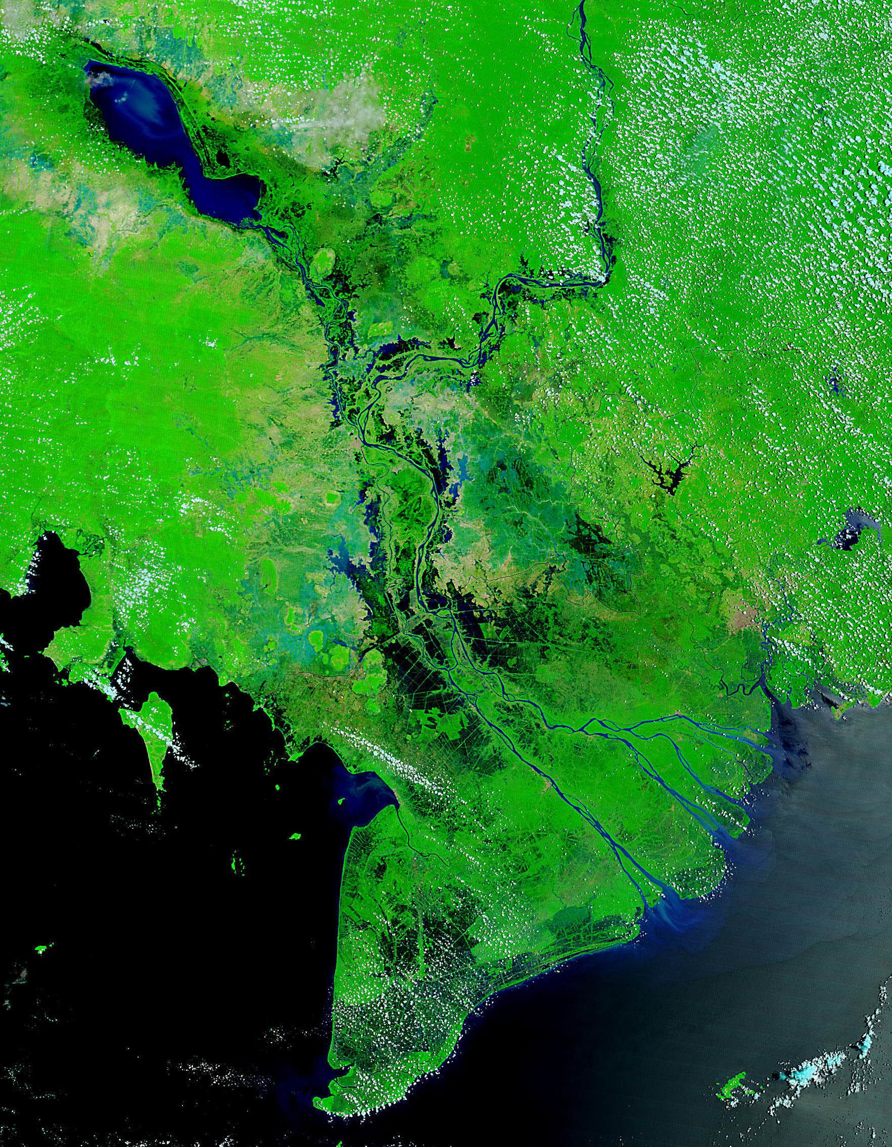 The Tonle Sap is the large brownish-green lake in central Cambodia. It connects to the Mekong River (brown ribbon running south from the top edge) via a smaller river. The Mekong River widens out into the Delta once it crosses the border into southern Vietnam. When the river is in flood, its silted delta outlets are unable to carry off the floodwaters, and they back up into the Ton le Sap, expanding the lake to cover as much as 4 times its low-water area. As the river flood subsides, the water reverses its course and flows from the lake to the sea. The effect is to reduce significantly the danger of serious floods in the Mekong Delta. The first major flood in 30 years occurred in October 1961, when the volume of water was too great for the TonIe Sap to hold. The disaster was worsened by being unexpectsd.
In South Vietnam the delta proper, approximately 26,000 square miles in area, was built up by the five branches of the Mekong, which total about 300 miles in length, and the system of three smaller riversthe Song Vam Co, the Song Sai Gon and the Song Dong Nai. The low, level plain, nowhere more than 10 feet above sea level, is very fertile, and cultivated land extends to the immediate shoreline in the vicinity of the river mouths. So much sediment is brought to the sea that the coastline to the south is advancing as much as 250 feet per year. More than 9,000 square miles of delta land are under rice cultivation. Drainage is effected chiefly by tidal action which differs greatly from place to place. The difference between high and low tides is about 3 feet on the Song Hau Giang and double that along the northern outlets of the Mekong and the Song Sai Gon. The southernmost tip of the delta, known as the Mui Bai Bung (Ca Mau Peninsula), is covered with dense jungles and the shoreline by mangrove swamps.
The people of the delta region live in villages made up largely of bamboo houses with tharohed roofs which are built directly on the ground. Village streets usually follow a regular pattern, and the entire community ordinarily is enclosed by a bamboo fence. Levees and dykes built for flood control are used extensively as village sites, and are often strung out along riverbanks and roads. During the flood period, the only dry land is that forming the banks of the canals and rivers. On such pieces of land, often isolated by the floodwaters from other communities and neighbors, stand the farmhouses with their small garden plots for growing vegetables and a few fruit trees.
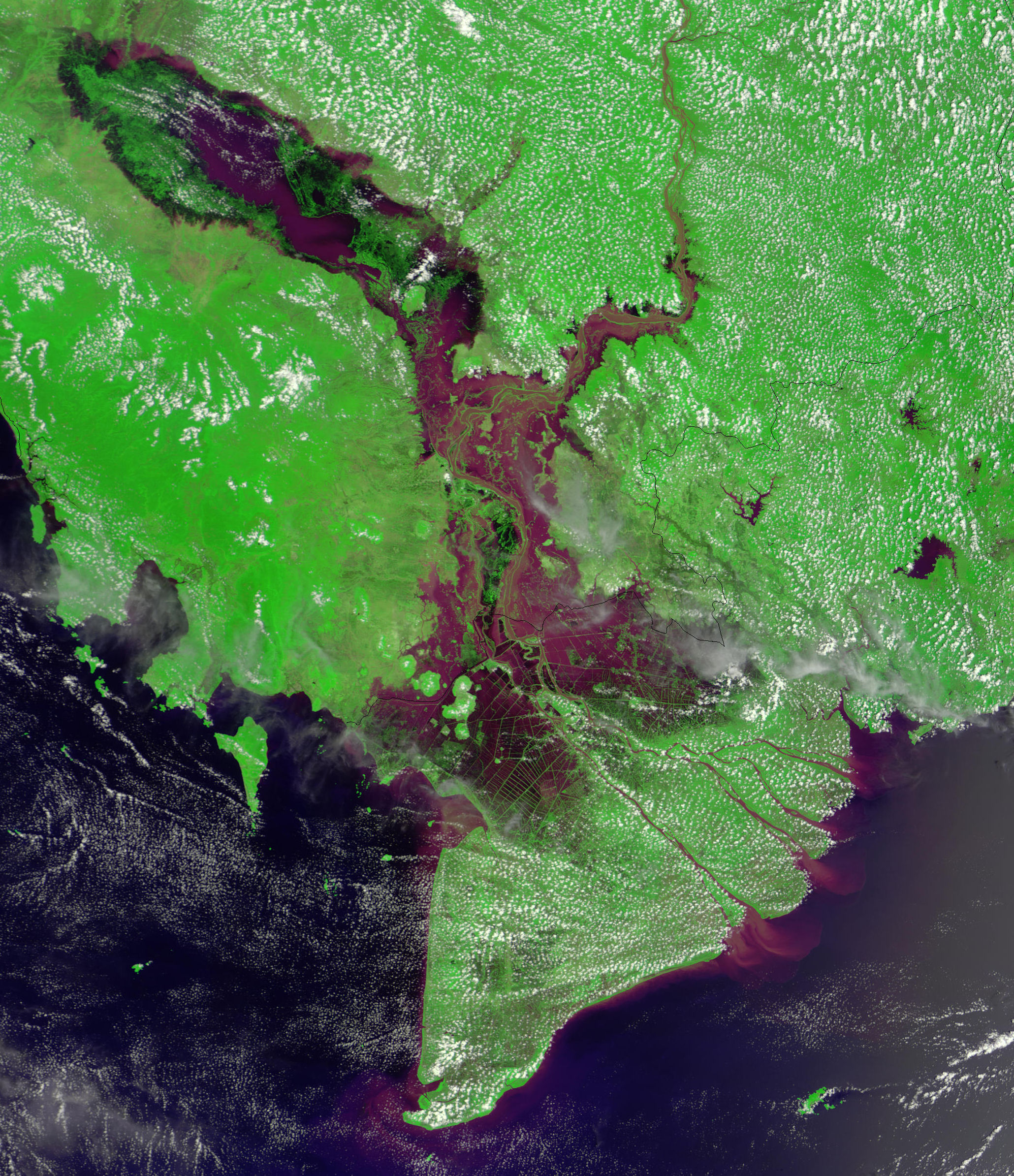 The monsoon season in Southeast Asia brings recurring, often devastating floods to countries in the region, but these floods also play a necessary role in the region's water cycle. These MODIS images centered on Cambodia reveal extensive flooding of the Mekong River, which comes in from Laos in the north, to the right of center in the images, and flows south through Cambodia and southeast through Vietnam to empty into the South China Sea. The false color image shows the brownish, sediment-laden floodwaters filling the Mekong Delta in southern Cambodia and Vietnam on September 15, 2001. It has been enhanced to bring out the contrast between the floodwaters and the lands, with sediment-carrying floodwaters in purple. Sediment can be seen flowing into the South China Sea as well. This year's floods have affected over a million people, and 100 people have been killed in Vietnam alone.
The monsoon floods bring not only devastation, but renewal. The large body of water just left of center in Cambodia is the Tônlé Sap. This shallow lake plays a changing role in the regional water cycle. During the dry season, the stream-fed Tônlé Sap drains via the Tônlé Sab River into the Mekong River. During the wet season (June-November), flooding of the Mekong reverses the course of the Tônlé Sab, roughly tripling the lake's size from about 3000 km2 to about 10,000. When the dry season returns, the lake once again begins to drain into the Mekong Delta, where it provides a flow of fresh water that balances the intrusion of salty seawater into the delta's agricultural lands.
|
NEWSLETTER
|
| Join the GlobalSecurity.org mailing list |
|
|
|