

Micronesia [FSM] - Geography
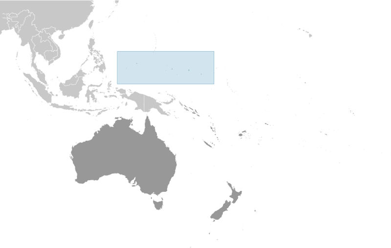
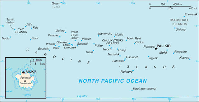
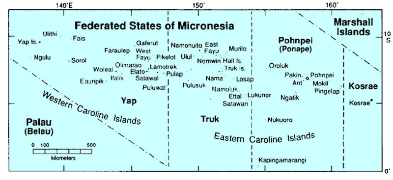
 Micronesia has an area of 702 sq km (435 sq mi) in four major island groups/states totalling 607 islands: - Pohnpei (Ponape), Chuuk (Truk), Yap and Kosrae (Kosaie). Some islands are of substantial size (Pohnpei, site of the capital Palikir, is a volcanic, mountainous island of 345.4 sq km), many are low coral atolls, and some mere specks that disappear at high tide.
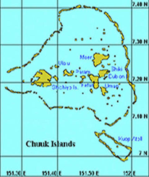
Chuuk Lagoon (formerly Truk Lagoon) is a sheltered body of water in the central Pacific, about 1,800 km north-east of New Guinea. It is part of Chuuk State within the Federated States of Micronesia. The atoll enclosing the lagoon - the "Pearl of the Carolines" - consists of a protective reef, 225 km (140 mi) around, forming a natural harbor 79 by 50 km (49 by 30 mi), with an area of 2,130 sq km (820 sq mi). It has a land area of some 127 square km (49 sq mi).
Chuuk State comprises the volcanic islands in the Chuuk Lagoon and some 24 outer-island atolls--in all, some 290 islands. Chuuk is the most populous of the FSM states with a land area of 49 square miles. Chuuk lagoon is the largest in the FSM. It is a world famous spot for scuba divers, with a sunken WWII Japanese fleet to explore on the floor of the lagoon. Chuuk was formerly known as Truk.
Yap (also known as Wa'ab) is located in Yap State of the Federated States of Micronesia. The island of Yap actually consists of four islands joined by a common coral reef. The land is mostly rolling hills densely covered with vegetation. Mangrove swamps line much of the shore. An outer barrier reef surrounds the islands and is visible in this space shuttle photograph. The state has a total land area of 102 sq km (39 sq mi).
Yap State consists of four volcanic islands plus 19 inhabited outer islands and atolls, with a total land area of 46 square miles. Yap State can be divided into two distinct spheres: "Yap Proper" and the "Outer Islands." Yap Proper is a cluster of relatively high islands with volcanic and continental rock, surrounded by a fairly wide reef platform. The Outer Islands are coral islands and atolls scattered over a wide area, with relatively low populations.
Pohnpei ( is the largest, highest, most populous, and most developed single island in the Federated States of Micronesia. The islanders of Pohnpei have a reputation as being the most welcoming of outsiders among residents of the island group. Pohnpei also contains a wealth of biodiversity and is one of the wettest places on earth with annual recorded rainfall exceeding 7.6 m (25 ft) each year in certain mountainous locations.
Pohnpei State is the national capital of the FSM. It is made up of one large volcanic island and six inhabited atolls, with most of its 133 square miles on Pohnpei Island. Pohnpei Island has a well developed barrier reef and associated lagoon.
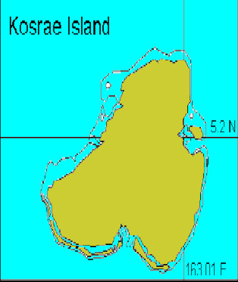
The State of Kosrae is the easternmost of the four states that make up the Federated States of Micronesia; it includes the main island of Kosrae and about a dozen nearby islands and islets. The island is located approximately 600 Km (370 mi) north of the equator, between Guam and the Hawaiian Islands. Its land area is approximately 110 sq km (42 sq mi).
Kosrae State is one volcanic island of 43 square miles, surrounded by a fringing reef. Its reefs and mangrove forests are considered to be among the healthiest in Micronesia. However, recent coastal development and land use patterns place the coral reefs at risk.
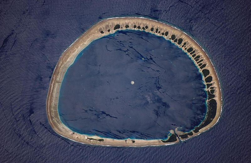
Classically shaped Nukuoro Atoll is one of 607 islands that make up the Federated States of Micronesia. It is also a municipality of the state of Pohnpei, Federated States of Micronesia. The atoll has a population of only several hundred people. The total area, including the lagoon, is 40 sq km, with a land area of only 1.7 sq km, which is divided among more than 40 islets that lie on the northern, eastern, and southern sides of the lagoon.
By far the largest islet is Nukuoro islet in the southeast, which is the center of population and the capital of the municipality. Vegetation is most prominent on the northeast and east portions of the atoll that face the dominant Easterly winds. Swells driven by these winds can be seen approaching from the east-southeast and wrapping around the atoll to produce an interference pattern on the downwind side. Water in the lagoon is calm in comparison. A coral head appears dead center of the lagoon.


|
NEWSLETTER
|
| Join the GlobalSecurity.org mailing list |
|
|
|