

Nepal - Geography
Nepal lies along the mountains of the central portion of the Himalayas. This rectangular piece of South Asia has acted as an important bridge linking two ancient civilizations of the Asian continent China in the North and India in the South. A landlocked country, Nepal is sandwiched between two giant neighborsChina and India. To the north, the Himalayas constituted a natural and mostly impassible frontier, and beyond that was the border with China. Nepal is landlocked by India on three sides and Chinas Tibet Autonomous Region to the north. West Bengals narrow Siliguri Corridor or Chickens Neck separate Nepal and Bangladesh. To the east are India and Bhutan. Nepal depends on India for goods transport facilities and access to the sea, even for most goods imported from China.
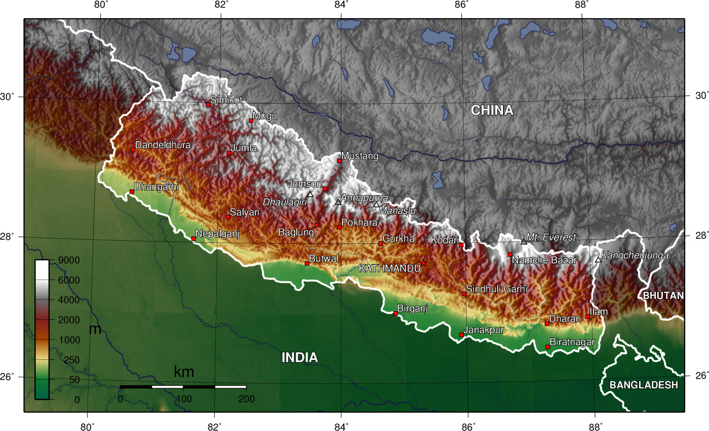 The land slopes downwards from the almost impenetrable and mighty Himalayan wall of the North until it reaches the Southern fertile Tarai plains. The narrow track of Tarai plains was once covered by thick tropical forest known as the Char Kose Jhadi. This malarial curtain kept settlements out until recently when the forests started being cleared and people from all directions came to settle down, making it the fastest growing habitated area in the country. India lies to the South of the Tarai. The river Mechi flowing from North to South is the Eastern border and the river Mahakali makes up the Western border of Nepal. Nepal was once much more extensive and included the present-day Indian Kumaun and Gadhwal and all the hill country West to the river Sutlej.
In complete topographic contrast to the Mountain and Hill regions, the Tarai Region is a lowland tropical and subtropical belt of flat, alluvial land stretching along the Nepal-India border, and paralleling the Hill Region. It is the northern extension of the Gangetic Plain in India, commencing at about 300 meters above sea level and rising to about 1,000 meters at the foot of the Siwalik Range. The Tarai includes several valleys {dun), such as the Surkhet and Dang valleys in western Nepal, and the Rapti Valley (Chitwan) in central Nepal.
The word tarai, a term presumed to be derived from Persian, means "damp," and it appropriately describes the region's humid and hot climate. The region was formed and is fed by three major rivers: the Kosi, the Narayani (India's Gandak River), and the Karnali. A region that in the past contained malaria-infested, thick forests, commonly known as char kosejhari (dense forests approximately twelve kilometers wide), the Tarai was used as a defensive frontier by Nepalese rulers during the period of the British Raj (1858-1947) in India.
The Tarai served as the country's granary and land resettlement frontier; it became the most coveted internal destination for land-hungry hill peasants. In terms of both farm and forest lands, the Tarai was becoming Nepal's richest economic region. Overall, Tarai residents enjoyed a greater availability of agricultural land than did other Nepalese because of the area's generally flat terrain, which is drained and nourished by several rivers. Additionally, it has the largest commercially exploitable forests. In the early 1990s, however, the forests were being increasingly destroyed because of growing demands for timber and agricultural land.
Between the Himalayas and the Tarai plains lie two mountain ranges running from West to East broken only by streams and rivers that run from North to South. These natural furrows have acted as natural barriers against the movement of people from one part of the country to the other which meant that the isolated communities could enjoy their own unique lifestyles without hindrance from others. The Mahabharat range reaching up to 10,000 ft in height takes up the largest area of the country and most of the Nepalese live on the slopes and valleys of this range. The Chure or Siwalik range, a single file of sandstone hills running from the East to the West, not exceeding 300 to 600 feet from the base, is the outer border of the mountainous ranges. The Tarai lies to the South of Chure and serves as the rice bowl of Nepal today.
The Nepal Himalayas consist of four major massifs making the formidable Northern wall throughout the length of the country-Nanda Devi (25,700 feet); Dhaulagiri (26,826 feet); Gosainthan (26,305); and Kanchanjunga (28,156 feet). The 29,028 feet Mount Everest lies roughly midway and gives off no main ridges.
This diversity in climate, plants and animals is matched only by the diversity of people and their individual lifestyles. Within such a small geographical area many different ethnic groups have settled on the slopes of separate mountains and in valleys. Throughout the ages, people from North, South, East and West settled in these parts bringing in their influences to create a unique culture. Records show that some 93 different languages are spoken in Nepal, besides the Nepali language itself. These people have lived in the difficult terrain for centuries toiling hard for a simple lifestyle. Their hospitality and honesty have been highly regarded throughout the world. They have learned to use the mountains not only for their livelihood and lifestyle but for their security as well. The harsh conditions and independent mindset nurtured the strong martial spirit of the Nepalese people, which has been well known throughout history. Ancient scriptures reflect that Nepalese forces had fought even during the Mahabharat war.
The rugged landscape offers some passes, albeit for only hardened human beings, to traverse. These breaks or passes have served as strategic points for contacts between the Northern and Southern civilizations since time immemorial. There are more than half a dozen passes through the Nepal Himalayas leading to the Tibetan plateau that have been regularly used to this day.
Apart from the numerous streams which originate in the mountainous country before furrowing their way to the South, three main rivers provide some basin landscapes in Nepal. The snow fed rivers rise in the Himalayas and provide a perennial source of water for irrigation, transportation and the like. They are: the Western basin of the Karnali, Central basin of the Gandaki and the Eastern basin of the Koshi.
|
NEWSLETTER
|
| Join the GlobalSecurity.org mailing list |
|
|
|