

Bandar-e Mahshahr (30°28'N., 49°11'E.)
 Bandar-e Mahshahr (30°28'N., 49°11'E.) (World Port Index No. 48450) is situated on Khowr Mahshahr, a branch of Khowr-e Musa. Mahshahr port is situated at the extreme northeast of Khuzestan province near the Khormousa estuary. It is bounded on the north by Ahwaz and Ramhormoz; on the east by Behbahan; on the west by Khoramshahr and on the south by the Persian Gulf.
Concurrent with the 40th anniversary of Iran's 1979 Islamic Revolution on February 1-11, National Iranian Oil Refining and Distribution Company (NIORDC) inaugurated more than 20 projects involving investments of $833.33 million and 861 million. The project to organize the port of Bandar-e Mahshahr is aimed at increasing the port's export capacity to 40 million tons.
The area of Mahshar is over 7,300 km2. The altitude of Mahshahr is 3m above the sea level. It consists of 3 districts: Central, Bandar Imam and Hendijan. Mahshahr is 1032km from Tehran, 151 km from Ahwaz, 95km from Abadan, 72km from Aghajari and 18km from Bandar Imam Khomeini.
Mahshahr, literally meaning "City of the Moon", is one of the most ancient ports in the Persian Gulf. Formerly called Mashur [bewitched], Mashoor or Bunder Mashoor, the city consists of two sections; the old and the new Mahshahr. The new Mahshahr came into existence when a loading facility for oil tankers was constructed. It had been the largest in the country before the Kharg Island oil loading facility was built. To date, Iran's largest natural gas plant and gas loading facility are in Mahshahr. The products of Abadan refinery are also exported by the same facility.
Completion of an agreement with the Iranian Oil Refining Company by which United Seamen's Service will operate a fullscale shoreside program for merchant seamen of all flags in the ports of Abadan and Bandar Mashur was announced in December 1955. Plans provide for institution of services in Bandar Mashur. With reorganization of the oil company to include British, American and other interests, company management recognized the necessity for reopening adequate facilities for seamen, and approached United Seamen's Service to take on the job. This move was an example of the increased international cooperation being given United Seamen's Service. Although the great majority of ships using Abadan and Bandar Mashur are British and Scandinavian, and few American-manned vessels ever touch at these ports, the agency was chosen because of its record of successful operation in Khorramshahr during World War II and because of the effectiveness with which its centers function in several major oil ports in Venezuela. Company officials had observed these installations at firsthand and had been impressed with the American way of meeting seamen's needs without segregation of ships' officers and unlicensed personnel or of Europeans and Asiatics.
The new section of the city is 3km far from the old section. According to the 1996 census, Mahshahr population was over 88,000. In 2001, the population was estimated at 100,000. The majority of the population dwell in the old section. Zohre and Jarahi rivers flow in the vicinity of the city. It has a few historical places including Aask (Kalat) city, Salehak Village and Basif Castle. In addition to its oil and gas installations, Mahshahr is notably important for its petrochemical industry.
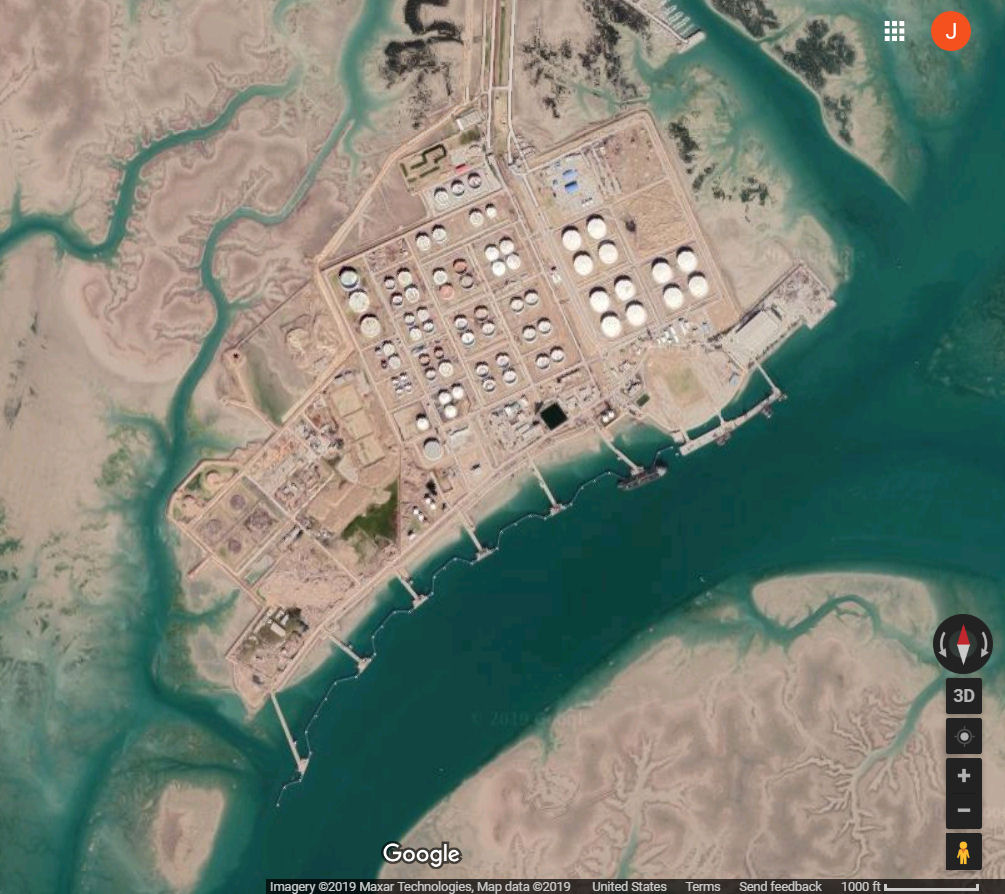
At the northwestern end of the Gulf, approx. 5 n.m. NE of Bandar Imam Khomeini. Bandar Mahshahr lies on the Khor Mahshahr, which runs from the head of the Khor Musa. The port lies about 6 miles ENE of Bandar-e Emam Khomeyni. Refined oil products are shipped via pipeline from the refinery at Abadan to the loading terminal at Bandar-e Mahshahr. Facilities also exist for the export of crude oil and oil products in drums.
The mean tidal range at HWS is 4.9m; at HWN the mean tidal range is 4m. Tidal currents in the vicinity of the port attain a velocity of 3 to 4 knots. Ships arriving on the flood tide are berthed starboard side-to; ships arriving on the ebb tide are berthed port side-to. The channel from Bandar-e Emam Khomeyni to Bandar-e Mahshahr is deep and clear of dangers. The approach channel has a depth of 12m. The SE shore of the river is foul but the outer extent of the foul area is marked by several beacons. There is a least depth of 12.2m just off the berths. The harbor berths consist of six T-head piers.
It is humid and maximum summer temperature is as high as 48 C. The average temperature for the whole year is about 25 C. The average humidity is 65% at 06:30am and 40% at 06:30pm. Average annual precipitation in Mahshahr is 195.8mm. In the city of Bandar Mahshahr (population of about 110,000 as of 2010), the air felt like a searing 165 degrees (74 Celsius) on July 31, 2015, factoring in the humidity. To achieve this astronomical heat index level of 165, Bandar Mahshahrs actual air temperature registered 115 degrees (46 Celsius) with an astonishing dew point temperature of 90 (32 Celsius).
The important ports of Bandar-e Khomeyni and Bandar-e Mahshahr are about 34 and 41 miles from the bar at the entrance of Khowr-e Musa. Between Damagheh-ye Bahrgan and the estuary of the Shatt al Arab, about 55 miles W, the coast is a complex of indentations and is poorly defined. The shores are almost entirely marshy or swampy and fringed by extensive mud flats. Most of the shores are subject to temporary inundation and are intersected by many tidal inlets and several large rivers. Backing the marshy shores is a low swampy plain, which extends a considerable distance inland before giving way to desert plains. Several small villages lie along the river banks and on the more solid parts of the plain.
|
NEWSLETTER
|
| Join the GlobalSecurity.org mailing list |
|
|
|