

Bandar Imam Khomeini 30°25'N 49°05'E
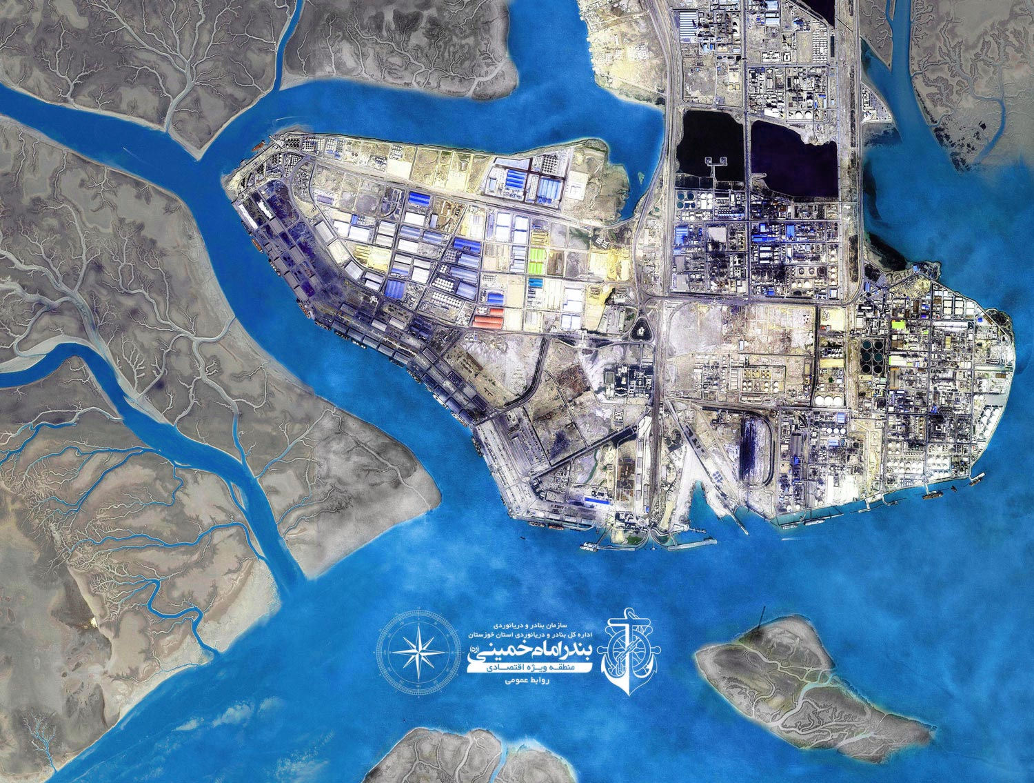 Contemporary with establishing of trans-country's railway in 1928 two wooden jetties were constructed at the north west of Persian Gulf at the end of mosses estuary (with geographical coordinates 30 degrees 25 minutes north latitude and 49 degrees 5 minutes east longitude). Afterward it would be knowned as shahpour port. Then 3 years later it turned into the most important center of entering and exiting goods. In the year 1973 the residential place of native people transferred to sarbandar (the city of Imam Khomeini) so situation of this port paved the way to be a more development port.
After the Islamic revolution of Iran, the port's name changed into Imam Khomeini port and in 1982 with the ratification of board of ministers named to Imam Khomeini port officially and established a new beginning towards progress.
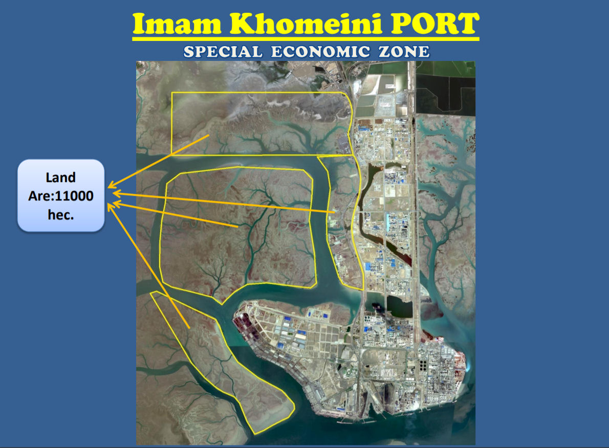
Imam Khomeini port started moving towards flourishing & changing through those two wooden jetties, and today by accomplishing 35% total country's sea trade. This port gives tiding of stable development through transportation industry. Imam Khomeini port SEZ, in the middle of ninth decade of outset of its activity, now makes performance of role as one of the most important regional transportation hub. In 2011 this port after alteration regulations system changed the role from an ordinary port to special economic zone and moreover, joining the adjacent lands with over 11000 hectares area has formed the largest special economic zone in the country.
 Bandar Imam Khomeini is located at the extreme North West of Persian Gulf, connected with Khowr e Musa River. Kowre Musa is a well marked water way with 42 miles length and 250 meters width. The Port handles all kind of Oil and Gas Products, Grains, Minerals, Chemicals, Containers and General Cargoes. Total Capacity is 37,000,000 Tons per Year.
North Winds predominantly blow North and North West with average speed of 12 to 14 meter per second. Rarely reaches 17 to 21 meter per seconds. Important Winds: LEAMIR wind which normally blows in September may cause inconvenience to the marine and industrial complexes. During Winter average air temperature 12 C° , and during Summer Average 35 C°, but may reach up to 50 C° with 99% humidity. Average Sea water Temperature during Winter 18 C° and during summer 34 C°.
Since there is not any metrological office in Bandar Imam Khomeini, the general average climate condition is obtained from nearest meteorological center located in Bandar Mahshahr (30°33N, 49°09E) with height of 6.2 meters from sea level, and information gathered from 1987 to 2003 as follow:
- Ave Max Temp : 35°C Ave Min Temp : 12°C Max Temp Recorded : 43°C
- Min Temp Recorded : 7°C
- Max temp in warmest month(June- July) :50°C
- Min Temp in coldest month(Dec-Jan) : 6°C
- Ave Humidity: 86%
- Ave number of days with dust : 87.4 days.
Maximum ship size is LOA 780ft. and draft 42ft.(S.W.). Vessels of 37 ft. draft may enter port at any time. Higher drafts depending on state of tide. Normal rise of tide about 11ft. Entry permitted day or night.
Shipping channels are well marked with light beacons and buoys and present no navigational difficulties in clear weather (30 numbers of beacons, 40 numbers of buoys and 2 light vessels). Small unlit tide gauge platform located on edge of the shoal west of shipping channel in Lat. 29°42'30"N., Long .49°03'48"E., approximately 1.75 miles west of Khor Musa Approaches Buoy No.4, and shown on Admiralty Chart. Approaching vessels should steer for Khor Musa Light Float, in position Lat. 29°36'32"N. , Long.49° 34'47"E., and from there a course should be set along marked channel for Buoy No. 12 in position Lat .29°53'20"N., Long. 49°12'32"E., and Buoy No.7 in position Lat. 29°53'37"N., Long.49°12'E.
Pilotage is compulsory. Application for Pilot and (along with ETA) to be made 24 hours in advance of vessels arrival at Khowr- e Musa Pilot Station, through Agent and Bandar Imam Khomeini Port via VHF channel 16 , and 6 hours before arrival Pilot Station to Bandar Imam Khomeini Port Control on VHF Channel 16. Pilotage operated by Bandar Imam Khomeini Port Authority from Buoy No.12 up to Bandar Imam Khomeini Anchorage.
|
NEWSLETTER
|
| Join the GlobalSecurity.org mailing list |
|
|
|