

Saint Vincent - Geography
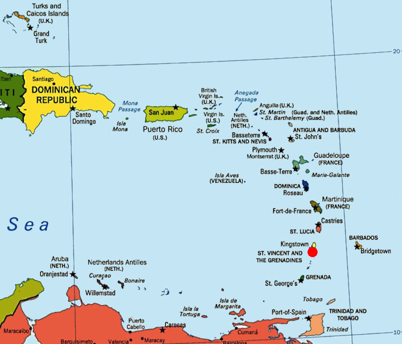
 St. Vincent and the Grenadines is located in the southern portion of the Lesser Antilles, islands formed from the peaks of a partially submerged chain of volcanic mountains. The island of St. Vincent lies 97 kilometers north of Grenada and 160 kilometers west of Barbados. The Grenadines are a chain of some 600 islets that stretch between St. Vincent and Grenada. The northern Grenadines belong to St. Vincent; the southern islands belong to Grenada.
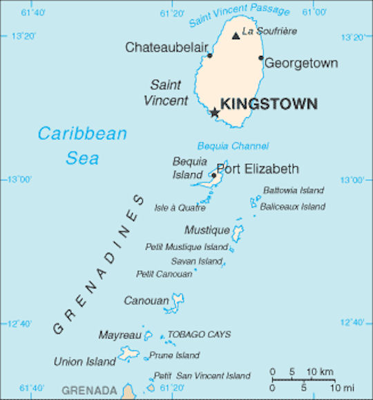
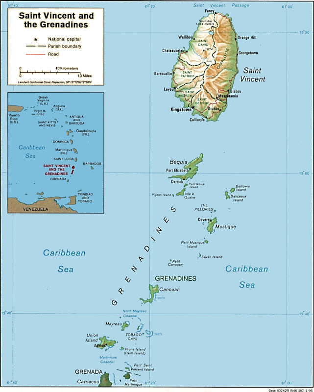
The total area of St. Vincent and its associated islands is 389 square kilometers, of which St. Vincent alone accounts for 345 square kilometers. The main island, which is approximately thirt-ytwo kilometers long and eighteen kilometers wide at its maximum breadth, is roughly oval shaped and has a north-south alignment.
A nearly impenetrable ridge of volcanic mountains forms the spine of St. Vincent and of each of the Grenadines. The highest peak is Mount Soufrière, which has an elevation of 1,234 meters. It is one of the two most active volcanoes in the Antilles (the other is Mount Pelée in Martinique), and its eruptions, although sporadic, can be violent. In 1902 a major eruption devastated the northern half of the island and killed 2,000 people. The most recent eruptions occurred in 1971, 1974, and 1979. Although all of these were also major eruptions, they were not as violent as the 1902 event, nor was there as great a loss of life. The summit region of Mount Soufrière includes several craters, one of which contains a fair-sized lake some 300 meters below the crater rim.
Powerful blasts from La Soufriere began on 09 April 2021 and continued into the night. Ash covered much of the Caribbean island of Saint Vincent , and the stench of sulphur filled the air after a series of eruptions from a volcano that had been quiet for decades. The thick dust was also on the move, traveling 175 kilometers (110 miles) to the east and starting to impact the neighboring island of Barbados. "Barbadians have been urged to stay indoors as thick plumes of volcanic ash move through the atmosphere," the Caribbean Disaster Emergency Management Agency said. The whitish powder caked roads, homes and buildings in Saint Vincent.
Prime Minister Keith Rowley is a former head of the University of the West Indies (UWI) Seismic Research Unit. The official did his Ph.D. on the La Soufriere volcano and he was present when it erupted in 1979. On 16 April 2021, two cruise ships from U.S. Royal Caribbean International and Greece's Celebrity Cruises companies will arrive in St. Vincent and the Grenadines to assist local authorities in evacuating about 15,000 people. "The 'Serenade of the seas' and 'Celebrity Reflection' cruise ships are already on their way. The crew will take all necessary measures to protect the health and safety of the evacuees," Saint Vincent and Grenadine Islands' government stated.
The island of St. Vincent is composed almost entirely of volcanic ash, other porous volcanic material, and lava. The windward side of the island slopes gently to the coast. The terrain there is undulating, with broad alluvial plains along the stream valleys. The leeward side has rugged, deeply dissected terrain. A number of fast-flowing streams that dry up before reaching the coast can be found at higher elevations. The soils on St. Vincent are extremely porous, and water seeps through them rapidly, leaving the surface very dry.
The island may be described as almost mountainous, there being little flat land except in the valley bottoms and around the shores of the larger bays. On the windward or eastern side there are old terraces or benches of marine erosion which form a narrow rim of comparatively level country skirting the coast. On the leeward side the land slopes steeply to the sea.
The form of all these mountains indicates that they have suffered prolonged and intense erosion. Though of volcanic origin, none of them shows a crater or a well-preserved cone. A series of radiating valleys, very deep and narrow, has been cut into the old volcanic pile, and between these valleys there are high steep-sided spurs, the summits of which are knife edges often only broad enough to serve as a footpath.
The whole of the island of St. Vincent is made up of ancient lava flows alternating with volcanic fragmental deposits or tuffs. These tuffs consist of boulders of all sizes imbedded in a matrix of coarse and fine gravel and sand, the whole being compacted into a rather soft rock, which is known as 'tuff agglomerate' or merely 'agglomerate.' These ancient agglomerates show that there have been many eruptions of the volcanoes of St. Vincent of the same character as that of 1902. They contain bombs as well as blocks. The beds of solid rock on the island show that many of the ancient eruptions were accompanied by extensive flows of molten lava. The porous agglomerates have suffered much from the decomposing action of percolating waters, and the lava beds show extensive alteration due to the same agency. Beautiful spheroidal weathering is common in the basalts of the southeastern part of the island and in the elevated beach conglomerates of the windward coast.
On 08 May 1902, the civilized world was startled by the news that a great eruption of Mt. Pelee on the island of Martinique had taken place, resulting in the annihilation of St. Pierre, the largest and most beautiful city in the Lesser Antilles. less notice, on 07 May 1902, the volcano known as La Soufriere on St. Vincent suffered a great eruption attended by much loss of human life and property.
An official estimate of the loss of life on St. Vincent by the eruption placed the number of killed at 1350. The actual number of bodies buried was 1298, including those of the wounded who died in the hospitals. Almost all of the people who passed through the fury of the eruption and escaped uninjured had taken refuge in cellars the only openings into which were on the side farthest from the crater and were, moreover, tightly closed with wooden doors or shutters.
The particular feature of the eruption of the Soufriere was the enormous amount of dust which was thrown into the air and distributed over a vast, somewhat elliptical area, the extent of which cannot be calculated for lack of data. The dust was spread like a gray mantle over the island, generally diminishing in thickness from the crater outwards, but collected in vast deposits in certain valleys on the sides of the mountain, where the conditions seem to have been particularly favorable.
The La Soufriere crater was probably unchanged in diameter, and about nine-tenths of a mile in diameter from east to west and eight-tenths of a mile from north to south. The beautiful crater lake, for which the Soufriere was famous before the eruption, had disappeared of course, but there was a small lake of boiling water in the bottom of the pit, from the southeastern quarter of which steam was ascending in a strong column. This column at intervals was carrying up quantities of black sand with it to moderate heights above the bottom of the crater.
The area of devastation on St. Vincent was very large in proportion to the total area of the island. It was about forty-six square miles, practically one-third the entire area of the island. From much of this devastated area, however, the ashes were washed off so rapidly by the rain that vegetation was soon asserting itself and within another year crops were growing there again.

|
NEWSLETTER
|
| Join the GlobalSecurity.org mailing list |
|
|
|