U.S. Virgin Islands - Geography
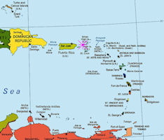
 The U.S. Virgin Islands (USVI), part of the Leeward Islands of the Lesser Antilles, is a U.S. territory located in the Caribbean Sea, about 600 miles southeast of Miami, Florida. Geographically the Virgin Islands constitute a part of what are known as the Leeward Islands, which, taken with the "Windward Islands to the south, form the chain known as the Lesser Antilles, reaching from Puerto Rico, the easternmost island of the Greater Antilles, southward in a semicircular sweep of 700 miles to the coast of South America.
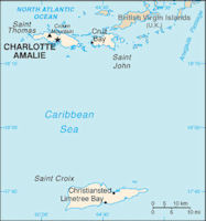
The USVI has a total area of 134 square miles, about twice the size of Washington, DC. The islands are hilly and forested, with limited arable areas, and most food is imported. The largest island is St. Croix. It lies about 40 miles south of the three other inhabited islands: St. John, St. Thomas, and Water Island. Those islands are located between the Commonwealth of Puerto Rico on the west and the British Virgin Islands on the east.
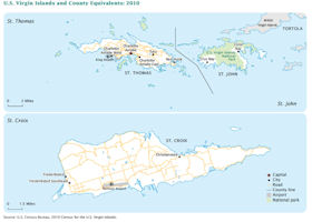
The U.S. Virgin Islands (USVI) is comprised of three large islands — St. John, St. Thomas, and St. Croix — and several small islands, all of which are part of the Virgin Islands Archipelago. Politically, the USVI is divided into three counties, St. John, St. Thomas, and St. Croix. St. Croix, the largest (approximately 215 square kilometers) and most populated island supports large industries such as tourism and oil refining.
There are about 50 smaller islands, ranging in importance from islands of less than a square mile in area to out-cropping ledges of rock. The islands lie between longitude 64° 34' and 65° 06' west, and between latitude 17° 40'- and 18° 25' north, and are thus well within the Tropics. St. Thomas is the territory’s capital and home to the port of Charlotte Amalie. St. John is located approximately four miles east of St. Thomas and is accessible only by boat (as it has no airport). Most of the land on St. John is parkland and undeveloped. Tourism is the largest industry in both St. Thomas and St. John Counties.
The islands of St. Thomas and St. John rise out of the ocean from a shelf on which the water is from 15 to 30 fathoms in depth, and may be considered a prolongation of the chain of islands known as the Greater Antilles — Cuba, Jamaica, Haiti, and Puerto Rico. St. Croix is 40 miles south of St. Thomas and St. John and is separated from the Virgin group by a tongue of the ocean from 12,000 to 20,000 feet deep. These islands are separated from Puerto Rico and the islands of Vieques and Culebra by the Virgin Passage.
St. Thomas Island has the principal harbor of the Virgin group — St. Thomas Harbor on which the town of Charlotte Amalie is situated. It is about 40 miles east of Fajardo, the nearest port on the island of Puerto Rico, and 70 miles from San Juan, the principal city and port of Porto Rico. St. Thomas lies south, 20° east and 1,442 miles distant from New York City. Although St. Croix is a considerable distance from other islands of the group, all may be encompassed within a circle whose radius is 25 miles.
St. Thomas Harbor, situated about midway of the southern side of the island of St. Thomas, is one of the best harbors in the Antilles. Situated as it is on the Virgin Passage, and commanding strategically this important gateway, it has been for a long time an important calling station for vessels plying between Europe and Central America and for vessels bound for South America by way of ports of the Lesser Antilles, and for ships sailing by way of the Panama Canal. Calling vessels may obtain supplies, such as coal, oil, and water, and ships of moderate size may be repaired in this harbor which is well protected in all but the most severe hurricanes.
Structurally St. Thomas and St. John are similar. The Virgin Islands as well as all others of the Lesser Antilles are of volcanic and coral origin and present a bold appearance on approach. They are described by Dr. Hornbeck as a mass of bluish hard granite stone porphyry.
The coral reefs found offshore of St. Thomas and St. John are distributed patchily around the islands and are described as fringing and patch formations. A developed barrier reef system surrounds St. Croix on its eastern and southern shores. Further offshore, bank reefs and patch reefs can be found at greater depths.
Closely dependent upon the reefs are the sand beaches for which these islands are so well known. Without the growth of the living coral that comprises the reefs, the beaches could not exist, for the sand here is composed of minute fragments of coral. The reefs also protect the beaches from being washed away by winter ground seas (distant storm-generated waves). A relationship has been established here that is enduring but delicate, for the reefs, and in turn the beaches, depend upon close tolerances. The sea must be clear and pollution free, its salinity must stay within close limits (30-36 parts per thousand), and its temperature must always stay between 21° and 27°C (70° and 80°F).
The coast lines of St. Thomas and St. John are irregular. Many of the branching or lateral ranges of mountains reach to the edge of the sea. Between these spurs or elevations bays are formed, which afford the protection of harbors on the leeward side of the islands. In these bays, and in St. Thomas Harbor as well, the freebooters and pirates of the seventeenth and eighteenth centuries are said to have found concealment and refuge while engaged in committing depredations on the Spanish Main.
The harbor of St. Thomas has long been celebrated for its unusual facilities and its many advantages. Protected as it is by two large islands — Water Island and Hassel Island — and fringing ledges, it is yet easy of access for vessels drawing under 30 feet of water. Its small size is the chief drawback to any development as a base for a large number of vessels, the area being approximately 1.3 square miles.
The great majority of the harbors in the islands of the Lesser Antilles are little more than open roadsteads, and shipping is afforded little shelter from the ^vdnds in more than one direction. The harbor of St. Thomas differs in this respect by being protected in all wind disturbances, affording ample shelter to shipping in blows less than those of the greatest hurricane velocity.
|
NEWSLETTER
|
| Join the GlobalSecurity.org mailing list |
|
|
|


