Guadeloupe - Geography
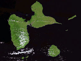
 Guadeloupe is one of the Caribbean’s most popular tourist destinations. It is a diverse territory consisting of two islands separated by a very narrow strip of water. One part of the territory is characterised by a mountainous landscape and tropical forests, the other a flatter landscape with mangrove swamp to the southwest. Much of the coastline of Guadeloupe benefits from the protection of coral reefs. Guadeloupe is densely populated and there are settlements in sensitive areas, resulting in deforestation, pressure on natural resources and pollution.
The Guadeloupe archipelago offers a great diversity of remarkable sites . Basse-Terre and the Saintes are derived from volcanic chains while the other islands of the archipelago are of coral origin. Guadeloupe therefore has beaches of white sand and black sand. The Conservatoire du Littoral has acquired 500 hectares of remarkable spaces to safeguard the seaside and the Guadeloupe National Park, created in 1989, covers 33,500 hectares of protected space. With the marine reserve of the Grand Cul-de-Sac-Marin of 3 700 ha, these are privileged areas for the preservation of local flora and fauna.
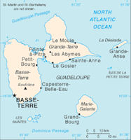
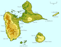
Due to its geological characteristics, Guadeloupe is classified in zone III according to the seismic zoning of France. The Antilles earthquake plan includes the renovation of community buildings, schools and hospitals to ensure that these buildings meet the highest seismic resistance standards. Basse-Terre, dominated by the Soufriere volcano, which culminates at 1,467 m, is covered by a very dense forest. Grande-Terre is, on the contrary, a plateau of low altitude favorable to breeding and agriculture.
Guadeloupe is the largest of the volcanic chain. Covering 1,628 km2, the Guadeloupe archipelago includes Guadeloupe itself (Basse-Terre and Grande-Terre) and the islands of Marie-Galante, Les Saintes, and La De´sirade. These islands are separated by an arm of the sea, named La Riviere Salee [the Salt River], from 100 to 300 feet in width. Grande-Terre(253 sq. m.) is the smaller and less attractive of the two. Streams, woods, and hills are wanting to it; the inhabitants live in fear of droughts, and they know how earthquakes can level villages. In 1843 Guadeloupe had its disaster, not in the form of a volcanic eruption, but of an earthquake of destructive force, 5,000 lives being lost in Point-a-Pitre alone, while devastation extended widely over the island.
Basse-Terre (365 sq. m.), is also subject to earthquake shocks, but it is as beautiful as Grande-Terre is ugly, with mountain-gorges, forests, extinct volcanoes, and torrents fed by a rainfall of 86 inches; the surface rises to the height of 4870 feet in the peaks of La Soufriere. These two islands constitute the body of the colony, but it has scattered dependencies: Desirade, an extinct volcano covering 11 square miles; Marie-Galante (58 sq. m.); and Les Saintes, comprising 6 square miles in five islands that bristled with cannon.
The western island bristles with hills, over which rises an active volcano; this is Guadeloupe; the eastern island is generally flat, or covered with low hills; this is called Grande Terre. These two islands are 200 miles in circumference. In Guadeloupe the hills attain a height of from 4,920 to 5,250 feet; the volcano soufriere is 5,110, and forms an oblique and truncated cone about 80,000 yards in circumference: this volcano, along with several others now extinct, has formed the soil of the island. The streams aro numerous, and with very high banks; the forest* cover one-fifth part of the island. In Grande Terre the soil rich and fertilo, has been formed by alluvia from the ocean: no streams; the coast is marshy, the climate moist and unwholesome.
Les Sainles, a group of four small islands, occupied by the French since 1648, and which are dependencies of Guadeloupe; they are dry and sterile, but healthy; their position and the excellence of their anchorage render them of importance in war time to Guadeloupe, the communications of which they protect: between the largest, called Terre d'en haul, and the Islet a Cabris, there is a good roadstead for the navy.
Marie Galante is 35 miles in circumference, it is not high, is fringed by a belt of reefs, has no harbours, and no streams, but it is fertile, grows mahogany, and rears an excellent breed of horses. The French settled there in 1648, and still possess it; it was taken by the British in 1691, 1759, 1794, and 1808.
The environment of Guadeloupe offers a great diversity of natural, terrestrial and marine environments. Guadeloupe is one of the 25 most biodiverse areas in the world. Several areas enjoy exceptional protection such as the Soufriere volcano and the upper part of Basse-Terre, an integral part of the Guadeloupe National Park.
Established in 1989, Guadeloupe National Park covers an area of ??33,500 ha (17,300 of which is in the central zone) and is thus the largest of the national parks in the Lesser Antilles. The park also manages the Grand Cul-de-Sac-Marin National Marine Nature Reserve (3 706.5 ha, recognized as a wetland of international importance) and the UNESCO Man and Biosphere Reserve, recognized in 1992. The latter is integrated into the national park with its peripheral zone and the RAMSAR International Wetland of the Grand Cul de Sac Marin (20 000 ha), which includes the national marine nature reserve.
Volcanism is a well-known phenomenon in the Arc of Lesser Antilles and especially in Guadeloupe; The island also has on its soil one of the largest and most active volcanoes in the region, the Soufriere. The volcano is located on the national park which bears the same name as it is and it is the only active volcano of the island. When it comes to volcanoes in Guadeloupe, it is inevitable not to mention the Soufriere, this 1467-meter high monster, a gray-type volcano that is one of the nine active volcanoes of the Caribbean. In the same way as the Madeleine, the Cistern or even the Broken Nose, it is subject to increased surveillance. It was in the 1950s that the volcano began to be monitored closely with the creation of a laboratory equipped with seismographs to study its underground activity. The Soufriere experienced its last magmatic explosion in 1440 when its last major eruption dates from 1976.
|
NEWSLETTER
|
| Join the GlobalSecurity.org mailing list |
|
|
|


