

French Guiana / Guyane Française - Geography
 French Guiana the most easterly of the the three Guianas, is the smallest of the group, both as regards area and population, containing twenty-nine per cent. of the area of British Guiana, and sixty-six percent of the area of Dutch Guiana. Compared with European countries, it shows less than one seventh of the area of the mother land, France, but it is twice the size of Denmark, more than twice that of Switzerland, nearly two and a half times the area of Holland.
It is located on one of the oldest and richest deposits of minerals in the world, a Precambrian geological formation, namely the Guiana Shield. This shield underlies French Guiana, Suriname and Guyana and some parts of Venezuela, Colombia and Brazil. Although its 83,534 km2 surface area appears small on the South American scale, French Guiana is the equivalent of 1/5 of the French mainland. It consists of two main geographical regions: the coastal strip, where 90% of the population live and the inland region covered by dense Amazonian rainforest.
The territory had 260,000 inhabitants spread over 22 municipalities. Different tribes populate Guyana: the Kali'na, Teko and Wayana are the main but there are also the Arawak, Palikur and Wayapi. The area, according to the best French authorities (as of 1900) was 15,000 square leagues, but the boundary line of French Guiana was not well defined, and had long been a subjcct of discussion with the Brazilian and Dutch governments. The boundary with Brazil, long disputed, was finally settled in 1900. The boundary with Dutch Guiana was settled in 1905.
The unique community covers 86,500 km², it is about the size of South Carolina. It is the biggest French department and it has the largest border of France which extends 730.4 km along Brazil. As the Amazonian forest covers a large part of Guyana, most of the population is concentrated on the coast in the cities of Cayenne, Saint-Laurent-du-Maroni and Kourou, where the Guyana Space Center (CSG) is located.
Cayenne, which is the chief town, is situated on the southern part of the island of that name. Cayenne was founded in 1604, the first settlement being established only a short distance from the site of the present city. It has been the permanent capital of French Guiana since 1877. The colonial population was composed of all nationalities; stores were kept by Chinese, and fish markets by Annamese, while domestic servants were principally Creoles born in Martinique.
The port is on the west of the town, at the embouchure of the river Cayenne, which divides before falling into the sea, where its twin banks form two headlands inclosing a natural harbor. The soil of the island is low and marshy. The hills are the only spots where agriculture is any way successful. The low land consists of extensive prairies or savannas, almost always flooded during the rainy season, which lasts nine months. These inundations are a source of permanent unhealthiness. The excessive drought of summer, under the influence of which clouds of noxious insects are generated, is again a scourge from which it is almost impossible to escape.
In 1714, the Jesuits founded an establishment at Kourou, which gradually drew together the neighboring Indian tribes, and so the town was begun. Situated 40 miles northwest of Cayenne, it is placed almost at the embouchure of the Kourou, in the cove formed by that river. The entrance of the river is defended by precipitous rocks, two miles in extent; and by a sandbank on the western point, which considerably reduces its mouth. The river is otherwise very fine, and navigable by small vessels.
The diseases bred by continuous moisture long made the country almost uninhabitable. Two great rivers mark the borders of Guyana, the Maroni to the west and the Oyapock to the east. The territory is one of the most humid in the world and composes the third largest water reserve in the world.
Biodiversity is particularly rich with more than 200 species of fish, reptiles and amphibians. A hundred species of mammals and 450 of birds. The Guyanese rainforest is composed of several thousand plant species, with 10 times more trees per hectare than in temperate forests.
The country is divided into highlands and lowlands, the former of which commence at the first cataracts of the rivers, and gradually increase in height towards the central districts, which they traverse in a granite mountain-range, which nowhere exceeds an elevation of 1000 feet. The lowest sections of this region are covered by dense forests of mangroves and are called pripris, while the higher sections, covered by the pinot or wassy palm, are known as pinotieres. This narrow strip of forest land is succeeded by grassy savannas.
Fifty miles inland the first low ridges of the highlands appear, marking the beginning of the forest section of the country. Mount Matouri, 836 feet above sea level, is the culminating point of the coast elevations. Farther inland are a number of short ridges, separated by river valleys. The low alluvial lands, which extend from the cataracts to the Atlantic, are mostly covered with vast forests, but the soil is well adapted to the cultivation both of grain of every kind, and all the products of tropical vegetation.
The country rises gradually in elevation toward the south until the Tumuc Humac Mountains are reached on the Brazilian boundary line, this range culminating in Mount Timotakem, 2,624 feet above sea level; towards its eastern extremity the range divides into a number of low but distinct ridges, such ridges extending northeast, east, and southeast.
Among the 20 navigable streams or rivers, the principal are the Marony, lying to the west, and the Oyapock to the east of Cayenne, the navigation of which is rendered dificult from the numerous cataracts and rapids by which they are obstructed. The overflowing of the rivers gives rise at various points in lower French Guiana to swamps or marshy savannas, which are covered with forests of mango-trees and palms, while in other parts likes are formed, the most extensive of which are those of Mapecucu.
The climate is equatorial with a short rainy season from mid-December to February, a short dry season in March, a long rainy season from April to mid-July and a long dry season from mid-July to mid-December. French Guiana has a rainy season, which lasts with short intormissions from Novcmher to June; and the heat is less oppressive than in most places in the West Indies. in consequence of the influence of the trade-winds, which bring with them the tcinpcrnte moisture of the Atlantic. The thermometer seldom rises above 90° or falls below 75°.
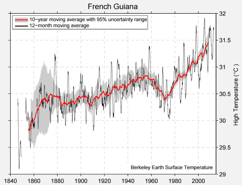 French Guiana will not escape the consequences of global warming. The same trends will be observed here as those around the world, such as the 1.2°C rise in temperature recorded at the Rochambeau station since 1950. Climate change will have several major effects. A rise in sea levels of between 10cm and 90cm would result in the coastal strip receding and the mangrove forest migrating inland, as well as more frequent floods. The more severe effects of the El Niño phenomenon would lead to longer droughts, as well as more violent rain on occasions. The Amazonian forest could give way to savannah, meaning a loss in biodiversity and large amounts of CO2 being released (by forest fires).
|
NEWSLETTER
|
| Join the GlobalSecurity.org mailing list |
|
|
|