

Bhutan - Geography
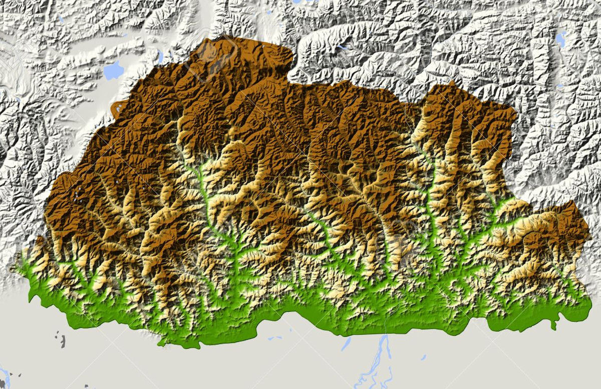 Early British visitors to Bhutan reported "dark and steep glens, and the high tops of mountains lost in the clouds, constituting altogether a scene of extraordinary magnificence and sublimity." Bhutan is located in the Eastern Himalayas spanning an area of 38,394 square kilometers. The entire area of this small kingdom is mountainous, excluding a rather narrow band of subtropical plains traversed by low valley and passes in the south. The lowest recorded elevation is a little over 300 meters above sea level and rises up to over 7,000 metres of glacier-covered mountains.
Physical geography consists mostly of steep and high mountains crisscrossed by a network of swift rivers, which form deep valleys before draining into the Indian plains. The country lies between latitudes 26' 45N & 280" 10N, and longitudes 88' 45'E & 92' 10. Within this latitudinal range are found a diverse biodiversity rich enough to be considered as one of ten global environmental hotspots. About 72.5 per cent of the area is under forests, and the law requires the country to maintain 60 percent forests cover for all times to come.
Centuries of isolationism, a small population, and topographical extremes have helped Bhutan maintain an intact ecosystem. Bhutan is possibly the only region in the world that provides a habitat such the mythical snow leopard and mighty tiger traverse, including other rare and endangered species like the takin, red panda and golden langur. With a rich ecological range of tropical lowlands to alpine meadows, Bhutan harbours an immense diversity of plants and animals that places it among the top ten countries in the world in terms of species density.
The climate varies from hot subtropical climate in the south to cold alpine slopes in the north. Human settlement is confined mostly to interior river valleys and a swath of southern plains; nomads and other tribes live in the north, raising sheep, cattle and yaks.
With temperatures rising four times faster than anywhere else in Asia, the Tibetan Plateau might soon lose most of its glacier and permafrost, affecting water supplies throughout Asia. Because of the impact of climate change, the glaciers are retreating rapidly, grasslands are shrinking as desertification expands, regional precipitation has become irregular, water levels are dropping in major rivers and the permafrost is thawing.
Bhutan has four major river systems: the Drangme Chhu; the Puna Tsang Chhu, also called the Sankosh; the Wang Chhu; and the Torsa Chhu. Each flows swiftly out of the Himalayas, southerly through the Duars to join the Brahmaputra River in India, and thence through Bangladesh where the Brahmaputra (or Jamuna in Bangladesh) joins the mighty Ganges (or Padma in Bangladesh) to flow into the Bay of Bengal. The largest river system, the Drangme Chhu, flows southwesterly from India's state of Arunachal Pradesh and has three major branches: the Drangme Chhu, Mangde Chhu, and Bumthang Chhu. These branches form the Drangme Chhu basin, which spreads over most of eastern Bhutan and drains the Tongsa and Bumthang valleys.
In the Duars, where eight tributaries join it, the Drangme Chhu is called the Manas Chhu. The 320-kilometer-long Puna Tsang Chhu rises in northwestern Bhutan as the Mo Chhu and Pho Chhu, which are fed by the snows from the Great Himalayan Range. They flow southerly to Punakha, where they join to form the Puna Tsang Chhu, which flows southerly into India's state of West Bengal. The tributaries of the 370-kilometer-long Wang Chhu rise in Tibet. The Wang Chhu itself flows southeasterly through west-central Bhutan, drains the Ha, Paro, and Thimphu valleys, and continues into the Duars, where it enters West Bengal as the Raigye Chhu. The smallest river system, the Torsa Chhu, known as the Amo Chhu in its northern reaches, also flows out of Tibet into the Chumbi Valley and swiftly through western Bhutan before broadening near Phuntsholing and then flowing into India.
One of the most rugged mountain terrains in the world, it has elevations ranging from 160 meters to more than 7,000 meters above sea level, in some cases within distances of less than 100 kilometers of each other. Bhutan's highest peak, at 7,554 meters above sea level, is north-central Kulha Gangri, close to the border with China; the second highest peak, Chomo Lhari, overlooking the Chumbi Valley in the west, is 7,314 meters above sea level; nineteen other peaks exceed 7,000 meters.
In the north, the snowcapped Great Himalayan Range reaches heights of over 7,500 meters above sea level and extends along the Bhutan-China border. The northern region consists of an arc of glaciated mountain peaks with an arctic climate at the highest elevations. Watered by snow-fed rivers, alpine valleys in this region provide pasturage for livestock tended by a sparse population of migratory shepherds.
The Inner Himalayas are southward spurs of the Great Himalayan Range. The Black Mountains, in central Bhutan, form a watershed between two major river systems, the Mo Chhu and the Drangme Chhu {chhu means river). Peaks in the Black Mountains range between 1 ,500 meters and 2,700 meters above sea level, and the fast-flowing rivers have carved out spectacular gorges in the lower mountain areas. The woodlands of the central region provide most of Bhutan's valuable forest production. Eastern Bhutan is divided by another southward spur, the Donga Range. Western Bhutan has fertile, cultivated valleys and terraced river basins. In the south, the Southern Hills, or Siwalik Hills, the foothills of the Himalayas, are covered with dense deciduous forest, alluvial lowland river valleys, and mountains that reach to around 1 ,500 meters above sea level.
The foothills descend into the subtropical Duars Plain. Most of the Duars Plain proper is located in India, and ten to fifteen kilometers penetrate inside Bhutan. The Bhutan Duars has two parts. The northern Duars, which abuts the Himalayan foothills, has rugged, slopping terrain and dry porous soil with dense vegetation and abundant wildlife. The southern Duars has moderately fertile soil, heavy savanna grass, dense mixed jungle, and freshwater springs. Taken as a whole, the Duars provides the greatest amount of fertile fladands in Bhutan. Rice and other crops are grown on the plains and mountainsides up to 1,200 meters.
Bhutan's most important commercial centers Phuntsholing, Geylegphug, and Samdrup Jongkhar are located in the Duars, reflecting the meaning of the name, which is derived from the Hindi dwar and means gateway.
|
NEWSLETTER
|
| Join the GlobalSecurity.org mailing list |
|
|
|