

São Tomé e Principe - Geography
 The islands of Sao Tome and Principe are situated in the equatorial Atlantic about 200 miles and 150 miles (320 and 240 kilometers), respectively, off the northwest coast of Gabon. Both are part of an extinct volcanic mountain range that extends to the north where it also includes the island of Bioko off Equatorial Guinea and Mount Cameroon on the Cameroon coast. The islands located in the Bight of Biafra, four in number, lie nearly equidistant from each other along a line extending SW from the head of the bight. The NE and largest island is Isla de Bioko (Masie Nguema Biyogo) (Fernando Poo); next is Ilha do Principe, then Ilha de Sao Tome, and finally Pagalu (Annobon), the outer and SW island.
These islands and the Cameroun Mountains, on the mainland, are of volcanic origin. All of these features are in line and were formed by the same upheaval. The basaltic and ferruginous rocks, of which the islands are composed, and the black sand found along the shores, are all evidences of volcanic activity. Isla de Bioko (Masie Nguema Biyogo) (Fernando Poo) and Pagalu (Annobon) form a province of Equatorial Guinea. Ilha do Principe and Ilha de Sao Tome are an independent republic.
The island of Sao Tome is 31 miles (50 km) long and 20 miles (32 km) wide and is the more mountainous of the two islands. Its highest peak reaches 6,640 feet (2,024 m). Principe is about 19 miles (30 kilometers) long and 4 miles (6 km) wide. Swift streams run down the mountains through lush forest and cropland to the sea on both islands.
An exclusive economic zone is the area beyond and adjacent to the territorial waters of a coastal nation which is subject to specific legal regimes established by international law. In an exclusive economic zone, the coastal nation has sovereign rights established by international law to explore and exploit the natural resources in the zone. The STP EEZ delineates an expanse of waters offshore São Tomé and Principe covering approximately 160,000 square km. The EEZ is measured from claimed archipelagic baselines. The territorial waters of STP extend to 12 nautical miles from the coast while the exclusive economic zone extends from the edge of the territorial waters to 200 nautical miles from the coast. The STP EEZ is the largest such zone in the Gulf of Guinea. Oceanic water depths around the two islands exceed 1,524 meters, depths that have only become feasible for oil production in the past few years; however, oil and gas are produced in the neighboring countries of Nigeria, Equatorial Guinea, Gabon and Congo.
The most characteristic feature of the coast of San Thome is the alternation of rocky promontories and sandy bays. Off it there are several islands. San Thome is somewhat difficult to approach. The coast of Principe is similar in character to that of San Thome, and Santo A1itonio Bay, on the east coast, is the most important inlet in the island. A number of rocky islets lie at varying distances from the coast. Both islands contain many streams, which all rise upon the mountains and descend as torrents, forming numerous waterfalls on the way.
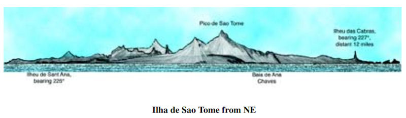
Ilha de Sao Tome (0°15'N., 6°37'E.) lies 82 miles SSW of Ilha do Principe. It is larger and of greater commercial importance than Ilha do Principe, but has a lack of sheltered anchorages. Calms, variable winds, and strong currents prevail in the vicinity of this island. 3.90 Ilha de Sao Tome is very mountainous and Pico de Sao Tome, its summit, rises at the W side of the central part. This summit attains a height of 2,024m [7,021 ft] but is often hidden by clouds. The sides of the peak are covered with dense forests and numerous streams flow down them. The island is reported to present three conspicuous peaks when seen from the NE at a distance of about 60 miles.
In the north of San Thome the old craters are well preserved, and in the south there are great volcanic dikes, but from whatever point it is viewed the island appears as a chaos of mountains cut by deep ravines. In the north and north-east there are considerable tracts of low-lying ground.
The water in the vicinity of the island is very clear and the bottom can be seen distinctly in depths of 10m. During the months of October and November, sperm whales are found off the S end of the island. When approaching Ilha de Sao Tome from the W, it is advisable, in order to take full advantage of the Guinea Current, for vessels to keep N of 1°30'N until the longitude of 6°E has been attained. Vessels will thereby avoid the South Equatorial Current, which is found in that latitude to the W of the above meridian and, at times, even farther N. This latter current sometimes surrounds Ilha de Sao Tome and to the N of the island, in a longitude of about 6°E, has been found to set to the W. The current usually sets between NNE and NNW at the E side of the island.
It was reported (2004) that the navigation lights on Ilha de Sao Tome are unreliable and may be missing or extinguished. It was reported 1995 that several fish havens had been established up to 5 miles off the coasts of Ilha de Sao Tome. They are marked by red buoys which have bamboo masts and red or yellow flags.
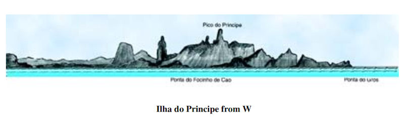
Ilha do Principe (1°37'N., 7°24'E.) lies 116 miles SW of Isla de Bioko. It has an extremely picturesque appearance formed by needle-shaped peaks and leaning mountain masses which rise abruptly from the high land of the interior. Principe is similar ill structure. The northern part, though lofty, is tame compared with the southern, which consists of steep and rugged mountains surrounded by gigantic natural obelisks of most fantastic shapes, the whole culminating in a peak 3,050 ft. above sea-level. In the vicinity of the rivers and in the lowlands near the coast there is much marshy ground.
The heavy rainfall and the great fertility of the soil have produced a growth of vegetation so rank as to render the island unhealthy. There are traces of extinct volcanoes in many parts of the island and large areas are covered with volcanic stones. The N part of the island, although high, is not so grand in appearance as the S part, which consists of a series of steep and rugged mountains, surrounded by several gigantic and fantastically shaped natural obelisks. The whole of this latter mass culminates in Pico do Principe (1°35'N., 7°24'E.), a prominent peak which rises to a height of 947m. The current in the vicinity of the island is variable, but is reported to usually set N or NE at a rate of 1 to 2 knots. Strong magnetic anomalies have been reported close off Ilha do Principe, especially in the vicinity of Baia de Santo Antonio.
Ilheu Bombom (1°42'N., 7°24'E.) forms, in reality, the N extremity of Ilha do Principe. This islet, which is 59m high, is connected to the main island by a sandy spit, on the W side of which lie two small and rocky islets. Ilheu Bombom is densely wooded and steep-to on its seaward side, against which the sea frequently breaks. A light is shown from a tower, 4m high, standing on the summit of the islet. A conspicuous radio mast is reported (1995) to be situated 0.5 mile S of the light. Pedra de Gale, 4m high, lies 2 miles NW of Ilheu Bombom and is a small black rock on which the sea always breaks.
|
NEWSLETTER
|
| Join the GlobalSecurity.org mailing list |
|
|
|