

Mauritania - Geography
Mauritania covers one million square kilometers on the northwest coast of Africa. It is bounded on the west by the Atlantic Ocean over more than seven hundred kilometers, to the south by the river Senegal. It shares more than two thousand two hundred kilometers of border with Mali to the east, four hundred with Algeria to the northeast and one thousand five hundred with the Western Sahara to the northwest. Most of Mauritania's territory is located in the arid and semi-arid areas of the Sahara and the Sahel. The country nevertheless has arable land in the alluvial valley of the Senegal River and in the oases.
To the north and north-west stretch of the Saharan peneplains, with little relief. It is nevertheless the highest point of the country, the Kedia al-Jill, which rises to nine hundred and fifteen meters. Trab al-hajra, an ensemble formed by the low plateaus of Adrar and Tagant, occupies the central part of Mauritania, and the desert of the Majabat al-kubra the eastern part. To the southwest is the valley of the Senegal river and to the south-east the basin of Hodh. The western coast, finally, is formed of sand dunes.
More than half of the country is part of the African Plain, the rest is a combination of vast plains with, scattered here and there, the plateaux of Adrar, Tagant and Affolé the heights of which vary from 200 to 800 metres with the highest point at 917 metres at Kédia dIdjil. The lowest altitudes are along the Atlantic Coast at under 50 metres. To the east of the littoral are continental dunes between 50 and 100 metres. Between the dunes and the Plateaux of Assaba, Tagant and Adrar there are ergs with scattered stony buttes, usually under 100 metres. In general the topographic variation affects neither the temperature nor the vegetation.
Sandy Mauritania provides ample material for dust storms. Mauritania possesses three kinds of landscape. One type is a skeletal soil where the underlying rock outcrops have weathered slightly, and saline soils from evaporated lakes rest on the surface. Another type is a reg, a desert pavement of tightly packed round pebbles. The third type of landscape is sand dunes. Sand covers most of the country, especially in its eastern region.
Saharan dust is a trans-oceanic traveler, periodically crossing the Atlantic during Northern Hemisphere summer. Satellite imagery of dust storms have helped scientists better understand the wide-ranging influence of Earths largest desert on distant locations. Scientists have connected Saharan dust storms to red tides in the Gulf of Mexico, to disease outbreaks on Caribbean coral reefs, and to soil fertility in the Amazon Rainforest. Some scientists also believe that Saharan dust outbreaks influence the formation of hurricanes in the Atlantic Ocean.
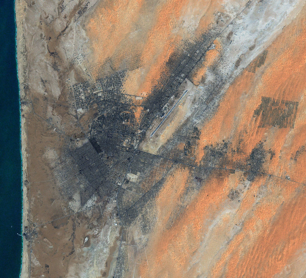 While many worry about urban areas slowly engulfing nearby nature, once in a while the tables are turned. Such is the case in Nouakchott, the capital of Mauritania. This city may be slowly obliterated by naturenot by creeping green vines run amok, but by creeping dunes of sand. Mauritania lies along the west coast of northern Africa, and holds part of the Sahara Desert. Even for the coastal capital, Nouakchott, Saharan sands pose daily challenges for the citys inhabitants. Hot on the citys heels are sand dunes, appearing as salmon-tinged beige ripples. Although they look appealing, these dunes threaten to overtake the city.
Sand dunes move through a few different means, all of them helped along by wind. One way that dunes can move is through saltation, where sand particles skip along the ground like a rock thrown across a pond might skip across the waters surface. When these skipping particles land, they may knock into other particles and cause them to skip as well. With slightly stronger winds, particles collide in mid-air, causing sheet flows. In a major dust storm, dunes may move tens of meters through such sheet flows. And like snow, sand avalanches, falling down the steep slopes of the dunes that face away from the winds, also moving the dunes forward.
Sand threatens buildings and crops not only in Africa, but also the Middle East and China. Drenching sand dunes with oil stops their migration, but this approach hurts the environment and uses a finite resource. Sand fences might also work, but researchers are still trying to figure out the best possible fence design.
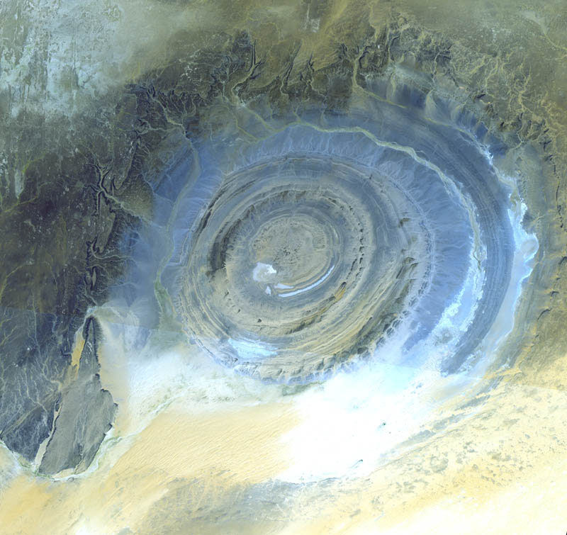 The bull's-eye target pattern of the Richât structure on the barren Gres de Chinguetti Plateau in the Adrar region of central Mauritania is an eye-catching feature when seen from space. It represents domally uplifted, layered (sedimentary) rocks that have been eroded by water and wind into the present shape. The 25-mile-wide structure is a 300-foot-deep landmark that has caught the eye of many an astronaut in Earth orbit. Sand has drifted northward and encroaches on part of the southern half of the 38-km wide structure. The Makteir desert abuts the plateau to the north. Initially interpreted as a meteorite impact structure because of its high degree of circularity, it is now thought to be merely a symmetrical uplift that has been laid bare by erosion. Although reminiscent of multiringed impact structures on the Moon, Mercury, and Mars, field and laboratory evidence suggests that the Richât structure is a dome of endogenic origin. The possibility that the Richat Structure was formed by a volcanic eruption also seems improbable because of the lack of a dome of igneous or volcanic rock. Reconnaissance gravity data do not support the presence at a reasonable depth of an igneous or diapiric intrusive mass nor do they suggest the presence of low-density breccia layers characteristic of impact structures. However, deep erosion could have removed the brecciated lens. Thus, the gravity data neither confirm nor preclude an impact origin for the structure. Why the Richat Structure is nearly circular remains a mystery. Some people call this bulls-eye in the Sahara the Eye of Africa.
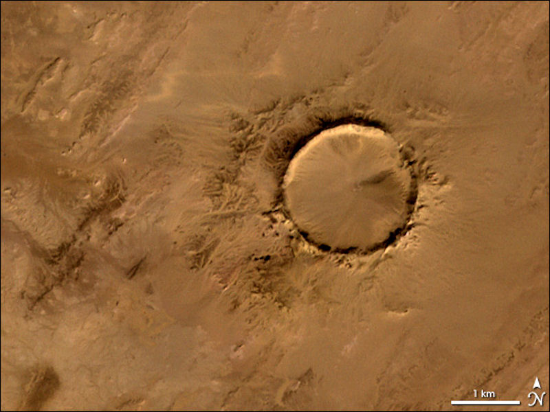 Deep in the Sahara Desert lies Tenoumer Crater in Mauritania. Nearly a perfect circle, it is 1.9 kilometers (1.2 miles) wide, and sports a rim 100 meters (330 feet) high. The crater sits in a vast plain of rocks so ancient they were deposited hundreds of millions of years before the first dinosaurs walked the Earth. Modern geologists long debated what caused this crater, some of them favoring a volcano. But closer examination of the structure revealed that the craters hardened lava was actually rock that had melted from a meteorite impact. Although it resides in ancient rock, Tenoumer is geologically young, ranging in age between roughly 10,000 and 30,000 years old. Once Tenoumers origin as an impact crater was understood, geologists began to wonder whether it resulted from a multiple impact event. Tenoumer and two other craters, named Temimichat-Ghallaman and Aouelloul, occur along an almost perfectly straight line. A 2003 study tried to resolve the issue by examining the ages of these craters. By looking at chemical compositions of rocks, geologists can estimate when they formed. Examination of Tenoumer and Aouelloul craters showed that they formed at different times and therefore could not have resulted from the same impact event.
|
NEWSLETTER
|
| Join the GlobalSecurity.org mailing list |
|
|
|