|
On 20
September 2000, a U.S. Navy submarine pulled slowly away from her berth in
Norfolk, Virginia to begin the final voyage of her 25-year career. The
solemn faces of the well-wishers gathered on the pier, many of whom had
served aboard the "Usta-Fish" in years past, reflected the one
thought on all of their minds - the USS L. Mendel Rivers (SSN-686)
would be missed. The days ahead were sure to prove bittersweet for the
crew, and the mood on the pier echoed that onboard the ship. This mission
marked not only the final voyage of a great naval vessel, but also the
eminent demise of an entire class. USS Sturgeon (SSN-637), which
first entered service in 1967 and was decommissioned in 1994, would have
only USS Parche (SSN-683) to carry on the legacy of her class once
the Rivers was put to rest. But first, L. Mendel Rivers had
things to do.
We were well prepared and eager to perform the task ahead, which at first
glance appeared to be a simple one - proceed to the Arctic Circle and
operate submerged beneath the polar ice cap for several weeks. Along for
the ride was a team from the Arctic Submarine Laboratory, who hoped to
profile ice thickness in shallow uncharted areas of the Arctic basin and
launch a large number of probes to gather scientific data on the ocean's
properties. When the scientific portion of our mission was complete, we
were to transit the Bering Strait and proceed to the Puget Sound Naval
Shipyard (PSNS) at Bremerton, Washington for final deactivation. Our
mission sounded straightforward, but we were quick to realize that the
challenges that lay ahead would test the very limits of the crew's skill
and expertise in managing this disappearing breed of ship.
|
This account of L. Mendel Rivers'
transit under the North Pole reflects my own personal perspective, that of
her Assistant Navigator. It's a tale focused on our challenges - and our
victories - in navigating the ship from one ocean to another by way of the
Arctic ice pack. L. Mendel Rivers was the last submarine on the
East Coast still to be equipped with the venerable Dual Miniature Inertial
Navigation System (DMINS). For years, this equipment has guided submarines
safely in submerged transits, and has proven much more capable than the
older navigation systems onboard USS Nautilus (SSN-571) or USS Skate
(SSN-578) when they first transited below the Arctic ice. As this story
will relate, however, there are serious hurdles to overcome when
navigating a submarine in extreme northern latitudes. Gyros, which provide
heading, and gyro-based inertial navigators, which provide position, do
not function normally at the North Pole because the tangential components
of the earth's rotational velocity are minimal. Even knowing this in
advance, and looking forward to the unique challenges that lay ahead of
us, we got more than we expected.
|
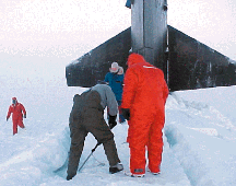
The Crew of USS L.
Mendel Rivers (SSN-686) digs through the ice in search of the
ship's hatch.
|
Our Captain, CDR David Portner, ensured
that our training and certification were thorough. The schedule of our
final upkeep was hectic - millions of dollars of specialized equipment had
to be installed and tested. Additional training was also necessary to
ready the crew for operation and maintenance of the new gear in a hostile
and unforgiving Arctic environment. Furthermore, shipyard preparations had
to be made to ensure a smooth transition for our arrival at PSNS.
Moreover, Rivers Sailors were also busy at home closing the loop on
last minute details in preparation for the lengthy separation from their
families. Burning the candle at both ends was nothing new to the crew of
the Rivers, though, and with a dedicated team effort we completed
our installations and training right on schedule.
Having bid farewell to Virginia for the last time, our track took us
northeast 1,500 nautical miles past the Flemish Cap before turning north
for the Denmark Strait. We took advantage of our time in transit to
conduct drills and training, all the way to the Marginal Ice Zone, just
north of Iceland. With the last available satellite broadcast copied, we
crossed under the polar ice cap.
Despite our preparations and training, isolated equipment problems on our
26-year-old boat kept us busy. The first bump in the road was the failure
of our electro-magnetic (EM) log's lower pit sword, which provides speed
input to the ship's navigation systems. This required us to drive the
15,000-mile journey using what is known as a "dummy log" to
input ship's speed manually. Operating DMINS in the undamped mode, which
was necessitated by the loss of the normal EM log input, required frequent
attention from the watchstanders. Surfacing through the ice every three to
five days for fixes and system resets became common.

As predicted, navigation continued to pose a challenge as we proceeded
north. The ship lost all heading reference when we surfaced at the North
Pole, since the Mk-19 Gyro became unstable in the high latitudes, and
DMINS began to operate erratically. We tried to restart both channels of
DMINS, but that quickly proved impossible. While we had fixed our position
using our Global Positioning System (GPS), the ship was left surfaced at
the North Pole with no compass to guide it! We had to resort to more
creative methods.
The Captain calculated our heading by shooting a relative bearing to the
moon and computed its Greenwich Hour Angle from the Nautical Almanac. This
told us what longitude line the ship was pointing. We verified this by
using a hand held GPS receiver topside, marking bow and stern waypoints
and checking the bearing between them. With this information, we submerged
the ship, executed a turn, recalculated our final course, and said a
prayer as we headed south away from the pole to find another suitable
place to surface the ship and restart our gyroscopes.
|
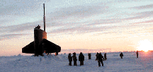
The crew of USS L. Mendel Rivers (SSN-686)
quickly came to realize that their mission to the arctic Circle
would prove to be one of the most challenging experiences of their
careers.
|
We drove 180 miles away from the pole at
flank speed in deep water. We were able to approximate driving a straight
line by keeping the stern marker line on the sonar display centered on own
ship's sound trace in relative display mode - in other words, we
"looked" backwards to make sure our wake was straight. As the
Assistant Navigator, I knew that our chances for a pinpoint,
hand-calculated dead-reckoning (DR) position were slim after 180 miles.
When you combine unknown currents and helm error, and compound this over
time, your error grows continually.
After the 180-mile sprint was complete, we found a surfaceable feature and
punched through. The moment of truth had come. The GPS fix indicated that
we were on the exact latitude line the quartermasters had calculated by
the hand DR, but the heading error placed us 145 nautical miles due east
of that position! That was tough to swallow. In hindsight, I was happy
enough just being on the right chart. The Mk-19 Gyro was re-started and
provided the heading reference to start DMINS.
One of the two DMINS channels came right up, but the other's inertial
measurement unit (IMU) would not, and had to be replaced. Eighteen hours
later, we were underway with three separate heading sources working well.
We completed our transit of the North Pole while the embarked scientific
team accomplished their own goals, dropping 77 under-ice
conductivity-temperature-depth probes along our track for collecting data.
With the excitement of the scientific mission behind us, the only obstacle
remaining was the Bering Strait passage, which would entail traveling
submerged 1,000 miles inside the 100-fathom curve with ice pack overhead.
Extra watches were stationed for this slow speed transit, and a modified
piloting team was manned for five days. Luckily, nothing unexpected
occurred during the transit of the strait, and we chopped to our SUBPAC
SUBNOTE after clearing St. Lawrence Island, setting course for our new
home. We tried to make the last 1,000 miles of the voyage as uneventful as
possible, even as we conducted drills and worked to qualify junior
personnel for future assignments.
|
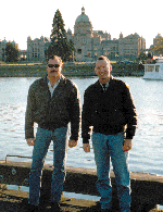
With their mission
completed, the crew set out for some well-deserved liberty in
Victoria, British Columbia.
|
As we surfaced triumphantly in the Straits
of Juan de Fuca and piloted into Victoria, British Columbia for a
well-deserved port call, I finally had some time to reflect on the past
seven weeks. PACSUBICEX 3-00 was a resounding success, and our crew was
walking tall from the realization of what they had accomplished in closing
a long and impressive chapter in submarine history. For more than 40
years, the U.S. Submarine Force has reigned supreme in the Arctic regions,
since Skate first surfaced at the pole in 1959. And, since 1975,
the L. Mendel Rivers had been there regularly to do her own part in
maintaining that supremacy. With Rivers' current decommissioning,
only Parche will be left to carry on the legacy of the Sturgeon-class
boats. Looking back over this proud tale, I have to ask myself: Will we
ever enjoy the same success we had with the Sturgeon class again,
or are we retiring our one true under-ice capability for good? I hope not;
because after this experience, I am convinced more than ever that we can
navigate anywhere, anytime, in spite of nearly any challenge. There is a
lot more to learn about the Polar Regions and I, for one, would like to go
back.
Chief Beach was the
Assistant Navigator of L. Mendel Rivers during PACSUBICEX 3-00 and
is now the Operations Chief at Submarine Squadron Support Unit, Norfolk,
Virginia. |