

CHAPTER 6
WHARF LOCATION AND LAYOUT
Section I. Location
CURRENTS AND SILTING
a. Ship docking requirements. A docking ship may need to turn broadside to a swift wind or current. Thus, the ship exposes a maximum area when it has the least self-control. Every ship needs to dock in a sheltered area, or at least in a place parallel to the wind and current. Mooring best occurs during slack water.
b. Scour. Bottom scour causes problems when currents remove supporting soil around bearing piles or in front of bulkheads. One solution is to drive long steel bearing piles or caissons into a hard nonerodible stratum. Another solution is to provide a rock cover on areas subject to scour.
c. Silting. Any interference with existing currents changes the erosion-deposit pattern. A wharf on solid fill may act like a groin. It creates a current-free backwater for deposits of silt and sand. A structure on pilings or caissons has less effect on the normal flow of the current than one on solid fall.
SUITABLE WATER DEPTHS
a. Water depths for planning purposes. A minimum low-tide water depth of nearly 35 feet has been standard. It accommodates virtually all deep-draft vessels. However, future military ports will require minimum water depths of 40 feet to accommodate containers and large tankers with over 50,000-hundredweight (cwt) capacities. Construction of wharves in water depths several feet less than desired may be justified only where--
(1) Dredging can reach the required depth as a part of the construction. Dredging must not endanger any in-place wharf.
(2) Short-term use is anticipated and lightening is feasible.
b. Minimum water depths. The wharf's intended use (POL, containers, or lighters) dictates minimum water depths for new construction. The operations order gives these depths.
ONSHORE TOPOGRAPHY
The ideal site is smooth, well-drained, and has open terrain. It is trafficable, has easy slopes, and stands above the reach of seas and swell. In undeveloped areas before invasion, planners may not detect features such as major swamps inshore of beaches. These may require major changes in planning. They may even require relocating the port. Shore traffic needs space for covered storage, container storage, marshaling areas, and bulk petroleum-handling facilities. Space is also needed for construction, operation, and supply units. Good, deep-water approaches with efficient road and rail connections are more important than onshore topography.
ROAD AND RAIL CONNECTIONS
a. Background. In the past, engineers have found it helpful to rehabilitate existing general cargo ports. Frequently, these ports already have rail and road nets suitable for most cargo handling. However, future ports must handle containers. If existing ports were not designed for container handling, engineers must develop new container ports. They must also rehabilitate and improve existing rail and road nets to accommodate containerized cargo.
b. Road nets. There are four pieces of line-haul equipment now scheduled for containers. They are the dual purpose 22 and 1/2-ton tactical break-bulk/container transporter; the dual purpose 34-ton break-bulk/container transporter; the commercially designed 6 by 4 truck-tractor; and the 5-ton, 6 by 6 tractor, M818. This equipment allows use of current roadway design criteria, with maximum grades of 10 percent, and maximum curves of 38 degrees. Steep grades, sharp curves, and unsurfaced roadways reduce efficiency, especially when transporting containers. They are hazardous. Surfaced roadways should have maximum grades of 6 percent on tangents and 4 percent on curves. Curves should not exceed 14 degrees for container operations.
c. Rail nets.
(1) Importance of rail nets. According to TM 5-370, "When available and when they can remain operable, railroads are the most effective and expeditious form of transport in a theater of operations." However, containers make railways only the second most effective means of supply transport. Tractor trailers with containers are the most effective.
(2) General specifications. Railway grades of more than 2 percent or railway curves of more than 12 degrees are dangerous, especially where grade and curvature combine. Thus, many otherwise satisfactory ports have rail connections from the wharf requiring racks too long to keep the grade within normal limits. One alternative is to use a pusher grade on the first division inland. Another is a truck-served rail terminal inland of the port.
OPEN AND COVERED STORAGE
Current Army guidelines for support of operations assume depot supplies will be uncrated and ready for issue. However, containerized supplies will comprise the bulk of all shipping in the future. Modern commercial container ports provide from 12 to 18 acres of storage and marshaling area per ship berth. These acres hold 1,000 40-foot, 67,200-pound containers or their equivalents. Military storage and marshaling areas should have at least 12 acres per ship berth. This area is served by modern material-handling equipment, such as front loaders, side loaders, and straddle carriers. Non-containerized supply storage estimates may differ for each port.
EXPANSION PROVISIONS
Port planners must first consider meeting immediate needs. Engineers must provide the most facilities in the least time. They continue development as originally prescribed or as redefined. Planning provides for expansion later. Provisions for expansion, as shown on layouts, include the following--
a. Extending piers or converting marginal wharves into piers. Tolerance is essential in water depths, pierhead limit lines, water approaches, original widths of piers and slips, and onshore transportation and storage facilities.
b. Expanding lighterage by converting swinging anchorages to fixed bow-and-stem. In sheltered waters, with more wharf use by lighters and new lighter wharves, they may convert to spreading moorings.
c. Planning clearance, rehabilitation, and construction in harbor areas not shown in the original layout.
d. Planning for more use of onshore areas later in the operation, after requirements for dispersion lessen.
CIVILIAN LABOR
Civilian labor is fairly efficient. Civilian labor reduces the need for engineer units and speeds up construction. In developed areas, rehabilitation may use local engineers, contractors, and superintendents with their normal organization of skilled workers. In many undeveloped areas, local businessmen have organizations that employ and supervise labor in agricultural and other pursuits. They can provide labor skilled in primitive construction methods. In either kind of area, engineers should consider housing, transportation, local customs, language difficulties, and race or religious complications. Engineers adapt construction plans to the methods and materials available. Local civilian labor lowers mobilization and demobilization costs because of the lower wage-scale and standard of living provided in work camps.
Section II. Layout
LENGTHS, WIDTHS, AND WATER DEPTHS
World War II ships provide models for current Army requirements. They provide lengths and drafts of cargo ships. They also determine standards for water depths and wharf widths for deep-draft and lighterage wharves. These standards are not sufficient for U. S. Merchant Marine container ships expected in future military operations. The following requirements are based on the larger high-speed ships of the U. S. Merchant Marine container fleet.
a. Single-length wharf. A deep-draft wharf should satisfy the following requirements--
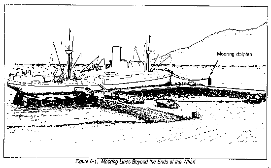
(1) The face of the wharf should be as long as the ship, usually between 750 and 1,000 feet. However, wharf length can match the length between the forward and stern hatches of the ship. This shorter length requires mooring lines beyond the ends of the wharf (Figure 6-1).
(2) A channel depth of at least 40 feet. This accommodates a fully loaded high-speed container ship.
(3) A minimum wharf deck width of 80 feet. This prevents congestion while loading and unloading containers.
b. Multiple-length wharf. A deep-draft wharf can berth one container ship for each 1,000 feet of wharf length facing deep water. Each 100 feet of wharf left over, facing any depth of water, can serve as a berth for lighters.
DISTANCE FROM SHORE TO WATER OF ADEQUATE DEPTH
a. Break-bulk cargo wharves.
(1) A quay is the easiest wharf to construct for a beach sloping steeply to a depth of 30 feet or more.
(2) Narrow, marginal wharves or floating wharves may be the only practical choices where deep water close offshore makes pile-driving impractical.
(3) A marginal wharf with approaches is best where a gentle beach slope continues uniformly to depths beyond the reach of piles.
(4) A pier is practical where depths range from 30 feet to the maximum depth for pile driving.
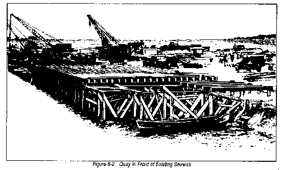
(5) Adequate depth near an existing seawall may make a marginal pile quay in front of the seawall the best solution (Figure 6-2). Only limited dredging is practical after wharves are built. Heavy dredging causes caving, which breaks wood piles.
b. Expedient container wharves. The wharves described above are not suitable for containers. The most promising design for expedient military container ports uses self-elevating, spud-type barge piers to construct finger-pier wharves. This design allows container wharves in water deeper than 50 feet to raise and lower. Wharves move up to 50 feet per hour can accommodate tides or dredging.
Section III. Methods of Location
BULKHEAD AND PIERHEAD LIMIT LINES
In the navigable waters of the United States and its possessions, the Corps of Engineers determines bulkhead and pierhead limit lines. It sets bulkhead and pierhead lines based on hydrology and navigation. These lines are fixed in all major harbors. Other maritime nations have similar regulatory bodies. No deviations from these lines are authorized. In undeveloped areas, assault units study tides and currents in harbors to locate channels, anchorages, and areas for wharves. Construction units follow up this work, determining limit lines and promulgating data among the agencies concerned.
EFFECTS OF STRUCTURES ON CURRENTS AND SILTING
Any structure extending into a harbor affects the tidal prism, currents, and sediment transport and deposit. Long-shore, wind, river, or permanent great currents may act together or individually to affect scour or sedimentation. Pile and spud-type barge wharves have less effect on currents and silting than do solid-fill quays. However, their effects are similar and could be more damaging to navigation. For instance, sedimentation around pile and spud-type barge wharves could damage the structure during its removal. Damage is worse if bottom materials are unstable and prone to caving or sluffing. This instability makes currents and silting very important factors when building expediently constructed military container ports using spud-type barges or similar methods.
TRANSPARENT TEMPLATES AND TERRAIN MODELS
a. Transparent templates. Special information needed for construction planning is shown on transparent charts of harbors. These charts record all available hydrographic information. They include the bulkhead and pierhead limit lines and emphasize the minimum depth contour for deep-draft wharves. They also show the contour below which depth pile driving is impractical. They show bottom characteristics important in dredging or filling operations. They also show locations of onshore road and rail connections and of in-transit storage areas and utilities. Engineers prepare transparent templates of possible wharf layouts at the scale of the chart. They fit them in place in various arrangements. Engineers then study and compare resulting layouts to determine practicality. They consider the materials and effort available, the best construction phasing, and the facilities available after each phase. They also consider possible interference between construction and operation, and any other matters which affect decisions. They then prepare a final layout showing the proposed construction by phase and priority.
b. Terrain models. Transparent templates help in the initial development of wharf layouts. First, a particular area is tentatively selected, then a three-dimensional terrain model provides the additional information needed for final planning.
(1) The contours of a large-scale, possibly enlarged, topographic map serve as a guide for cutting successive layers (elevations) of urethane. The desired scale determines the thickness of the layers.
(2) The urethane layers are glued together using a sheet of plywood as a base.
(3) Land areas are painted brown, bodies of water blue.
(4) Facilities are placed on the model according to the initial layout on the transparent templates. They are then changed according to dictation.
WORK-HOURS, MATERIALS, AND EQUIPMENT
a. Current methods.
(1) General. Comparative studies of personnel, materials, and equipment, follow this pattern:
* At theater level, engineers compare the materials and effort required to construct or rehabilitate facilities at the various ports. Planners then choose the best, based on development and theater priorities.
* At theater Army or bass-development level, engineers compare types and locations of facilities within a port.
* At engineer group and battalion levels, engineers compare construction methods and materials.
(2) Planning. FM 101-10-2 gives factors, materials, and personnel requirements for overall planning and estimating of general and break-bulk cargo port construction.
(3) Detailed estimates. Detailed time-work studies are based on--
* Job records of troop units for similar projects.
* Job records of the available major and local contractors. These records show the level of personnel training, experience, and productivity required.
* Work-output data from manuals or civilian engineering handbooks from unit libraries. Allowances are made for such factors as darkness, weather, delay in delivery of construction material, and inexperienced operating personnel.
b. Future methods. Most military ports of the future will be expedient container ports. They will accommodate fully-loaded 20- to 40-foot, 44,800- to 67,200-pound containers. Current recommendations are to build them with large, prefabricated, spud-type barge piers, which are capable of rapid erection, disassembly, and relocation. These capabilities should reduce the work-hours, material, and equipment needed to build and rehabilitate military ports.
SCHEDULING OF CONSTRUCTION AND EXPANSION PHASES
a. Current methods.
(1) Construction schedules. Engineers frame construction schedules to show, in detail and sequence, the time planned for all operations. They tabulate equipment, work-hours, and personnel for each principal operation. The construction schedule is based on--
* Time allowed for completion.
* Equipment available.
* Type of labor available: regular troop units, reserve troop units, prisoners of war, local contractors, or international contractors.
* Planned delivery of construction materials.
* Logical sequence of operations.
* Necessary delays between operations.
* Weather.
(2) Time schedules. Planners set time schedules for construction and use that allows for easy port operation and later expansion.
(3) Network analysis. Engineers may use network analyses, such as Critical Path Method (CPM) and Program Evaluation and Review Techniques (PERT). These ensure complete planning and increase confidence in schedules.
(4) Port construction phases. Current procedures for port construction in undeveloped areas fall into three phases:
* Phase l--Preliminary. This phase includes all requirements from the arrival of construction units to the beginning of construction of deep-draft wharves.
* Phase 2--Initial construction. This phase continues to the point when the first cargo ship berth is fully operational. It includes road and rail connections, water supply, electric illumination, and bulk POL facilities which receive liquid fuels directly from tankers.
* Phase 3--Completion. This phase ends when all authorized facilities are fully operational.
b. Future methods. Designs for future military port construction use large, prefabricated, spud-type, barge/pier components which can be elevated. This capability simplifies planning to get the components to the job site.
Section IV. Dimensions and Approaches
MINIMUM LENGTHS, WIDTHS, AND APRONS
a. Current U. S. Army recommendations are that military expedient container port wharves be 80 feet wide by 900 feet long. An upper width limit of 90 feet is enough.
b. No container wharf will have covered sheds. Existing wharves with covered sheds were built to accommodate noncontainer cargo ships that do not require a full 60-foot wharf apron for working space. This working space has a minimum width of 40 feet.
WIDTH OF SLIPS
a. Current guidelines. Current pier layouts show a minimum 250-foot width of slip between piers, each accommodating one ship. This figure is about four times the beam of the average cargo ship. For piers accommodating more than one ship in length, the minimum is 300 feet. Berthing of ships is quicker and safer if slips between double-length piers are widened to about 500 feet.
b. Projected guidelines. Most container ships of the future will have beams of 100 feet or more. This means that the width of slip between piers will be at least 400 feet to accommodate only one ship length. However, future military ports will have mostly single finger-piers constructed with self-elevating, spud-type barge units. Slips will be uncommon.
WIDTH OF APPROACHES TO OFFSHORE WHARVES
a. Current break-bulk cargo wharves. In effect, an approach is a bridge from the road on shore to the deck of an offshore wharf. The width requirement is the same as for bridges: a minimum of 14 feet between curbs for one-lane; 24 feet for two-lanes.
b. Future container wharves. Recommended Army designs specify causeways (approaches) of expediently constructed container wharves with 60- by 150-foot units for 4-lane traffic. This traffic is conducive to military container handling.
APPROACH FLARES TO MARGINAL WHARVES
a. Current break-bulk cargo marginal wharves. An approach flare in the triangular area between the approach and the inshore edge(s) of the wharf deck can provide turning space. Vehicles arriving on or leaving a marginal wharf need a 90-degree turning space. The approach is built at a 45-degree angle. It has a length of three pile bents along the approach or, a minimum of about 35 feet inside the curb, as measured along the approach.
b. Future container wharves. Most future container wharves will be finger-piers, not marginal wharves. The 60-foot width proposed for future container ports, however, is sufficient for a marginal wharf approach. It would require no approach flares for turning vehicles.
APPROACHES TO SINGLE-LENGTH, BREAK-BULK CARGO WHARVES
Engineers may build a marginal wharf for one ship with a one-lane approach at each end. This arrangement permits more efficient wharf operation than the single two-lane approach to a T-wharf. The unloading of lighters on the inshore face of a wharf built for discharge on one side only is inefficient. If necessary, the wharf can be widened for two-sided discharge. In this case, a draw-span for access of barges and small ships to the inshore face can be constructed in one or both approaches to a U-type wharf. If desired, engineers can design new approaches to a container wharf.
APPROACHES TO MULTIPLE-LENGTH WHARVES
a. Current break-bulk cargo wharves. An offshore marginal wharf long enough for two or more cargo ships normally has a one-lane approach at each end and two-lane approaches at intervals of 500 feet in its length. This arrangement permits a separate circuit of one-way traffic past each ship. Additionally, the approaches improve the transverse stability of the wharf.
b. Future container wharves. Multiple-length container wharves are unlikely in future military construction. However, they could be constructed with the following components for current military container port designs:
(1) 80- by 300-foot barge piers to construct the wharf.
(2) 60- by 150-foot barge piers as approaches at each end and at 1,000-foot intervals.
(3) Cranes to off-load from one side only, not both.
|
NEWSLETTER
|
| Join the GlobalSecurity.org mailing list |
|
|
|