

CHAPTER 3
Water Source and Water Point Development
Section I
DEVELOPMENT OF WATER SOURCES
BASIC GUIDELINES
Development of a water source includes all work which increases the quantity of water, improves its quality, or makes it more readily available for treatment and distribution. Avoid elaborate developments. Also, do not make a temporary source permanent until you survey the area for a source requiring less work. Finally, regardless of the type of source and climate, there are several things to consider in the development of intake points. These considerations involve both intake hoses and pumps.
Intake Hoses
All intake hoses or pipes should have an intake screen regardless of how clear the water is. Protect suction screens from floating debris which may damage, clog, or pollute them. Proper anchorage of suction lines and screens prevents puncture of kinked lines, damage to the screen, and loss of prime. Also, water at the intake point should be as clear and deep as possible. The screen on the suction hose must be at least 4 inches below the water level. This helps to keep the screen from becoming clogged with floating debris. It also prevents loss of prime from air getting into the suction line.
Pumps
The practical limit of suction lift of raw water pumps issued with field water purification equipment is 25 feet at sea level. Suction lift decreases at higher altitudes. Also, the pumps must create a partial vacuum in the suction line. Therefore, the raw water intake hose must be airtight for the pump to work properly.
DEVELOPMENT OF INLAND WATER SOURCES
There are a number of development considerations and techniques which apply to inland types of water sources. They are discussed below.
Inland surface water is the most accessible type of water source. This source lends itself readily to the purification equipment common to quartermaster units. Surface water is the most easily developed source of water. There are various methods of constructing intake points for inland surface water sources.
Rocks and stakes. If the source is a stream and the stream is not too swift and the water is sufficiently deep, prepare an expedient intake by placing the intake screen on a rock. This will prevent clogging of the screen by the stream bed and provide enough water overhead to prevent the suction of air into the intake screen. If the water source is a small stream or shallow lake, secure the intake hose to a post or pile as shown in Figure 3-1.

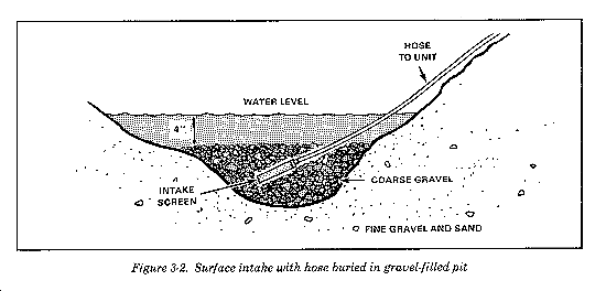
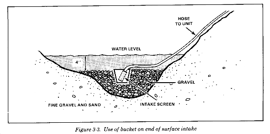
Pits. When a stream is so shallow that the intake screen is not covered by at least 4 inches of water but the source must be used, a pit should be dug and the screen laid on a rock or board placed at the bottom of the pit. Line pits dug in streams with clay or silt bottoms with gravel to prevent dirt from entering the purification equipment (Figure 3-2). Surround the screen with gravel to prevent collapse of the sides of the pit and also to shield the screen from damage by large floating objects. The gravel also acts as a coarse screen for the water. Provide a similar method by enclosing the intake screen in a bucket as shown in Figure 3-3).
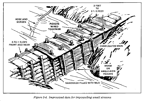
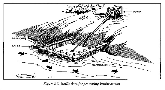
Dams. Raise the level of the water in small streams to cover the intake screen by building a dam as shown in Figure 3-4). In swift flowing streams, construct a wing or baffle to protect the intake screen without impounding the water (Figure 3-5).
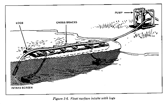
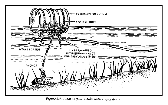
Floats. In addition to floats provided with the purification equipment, use floats made of logs, lumber, sealed cans, or empty drums to support the intake screen in deep water. They are especially useful in large streams where the quality of the water varies across its width or where the water is not deep enough near the banks to cover the intake screen. Cover the intake with an adequate depth of water by anchoring or stationing the float at the deep part of the stream. Secure the intake hose to the top of the float, allowing enough slack for movement of the float. If you use support lines to secure the float to the banks, alter the position of the float to correspond to changes in depth by manipulation of the lines. The chief advantage of a float intake is the ease with which the screen can be adjusted vertically. Figures 3-6 and 3-7 show two types of improvised floats.
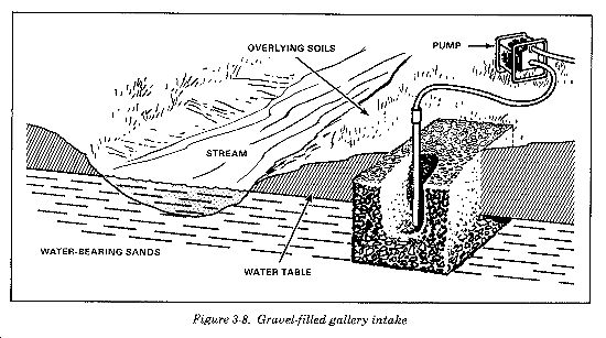
Galleries. Engineer units can improve the quality of water from muddy streams by digging intake galleries along the bank (Figure 3-8). To do this, they dig a trench along the bank. The trench must be deep enough to allow the water from the stream to seep into it and to intercept ground water flowing toward the stream. They fill the trench with gravel to keep the sides from collapsing. Then they place the intake screen in the gravel below the waterline. A gallery requires a lot of work, but it may be worth it. It reduces the amount of chemicals needed for coagulation, extends the life of filter cartridges, and extends the filter run between backwashing.
DEVELOPMENT OF GROUND WATER SOURCES
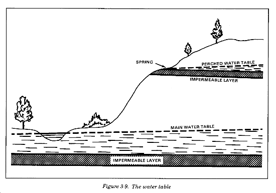
When surface water supplies are inadequate or unusable, develop ground water supplies. Subsurface or ground water is water existing below the earth's surface. In most regions the ground is saturated with water to a depth that depends largely on the type of rocks and soil, the amount of rainwater, and the topography of the land. This is the water table. The water table is not a level surface, but it is irregular and reflects the surface features, rising high under the hills and falling back low under flat areas (Figure 3-9).
Aquifers
An aquifer is a layer of rock below the water table from which you obtain water. It is sometimes referred to as a water-bearing formation or water-bearing stratum. Aquifers can be found in almost any area.
Types of Springs
Water which emerges at the surface naturally with a distinct current is called a spring. When a distinct current is not present, the flow is called a seep. Most springs and seeps represent water from rain or snow on some nearby higher ground which moves underground to where it comes up out of the ground. Its underground course depends on the type of soil it moves through. In some springs, the water bubbles up with a measurable force, indicating that it is under pressure. These are called artesian springs and will be discussed later. Any spring having a temperature higher than the yearly average temperature for a given region is termed a thermal spring. This indicates a source of heat other than that of the surface climate, of which magmatic heat is an example. Based upon the pressure of the emergent water, any spring or seep which is not artesian may be classified as the gravity type. Gravity springs and seeps are those in which subsurface water flows by gravity from a high point of intake to a lower point of issue. The two most important types are--
- Water table springs and seeps, which occur where the water table comes near or intersects the surface of the ground.
- Contact springs and seeps, which occur along an exposed contact point, like along a hillside. Water table springs and seeps are normally found around the margin of depressions, along the slope of valleys, and at the foot of alluvial fans. Contact springs appear along slopes but may be found at almost any elevation, depending on the position of the rock formations.
Spring Development
Develop a spring by enlarging the outlet of the spring and by building a dam and guiding the water to storage. To reduce possible pollution, clear a spring of all debris, undergrowth, top soil, loose rocks, and sand. Improve springs by building collecting boxes or digging ditches and tunnels. Collecting boxes or basins can be of wood, tile, or concrete. They collect water which flows from rocks under the force of gravity. The box should be large enough to hold most of the flow. Place it below the ground level so that only the top is slightly above the surface. Tightly cover the box to prevent contamination and decrease evaporation. Design the inlet to keep out surface drainage and prevent pollution. Fence the area and provide proper drainage. A screen on the overflow pipe keeps out insects and small animals. Another screen on the intake pipe keeps large suspended particles from being taken in by the raw water pump. To get water from a seep or contact spring, dig deep, narrow ditches leading from the spring to the point of collection. Another method is to build pipeline tunnels from the spring to the collection point. Large-diameter pipe is more suitable for this purpose. Trap water from the tunnels or pipes by a dam at the point of collection.
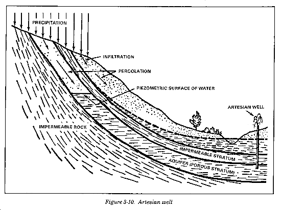
Artesian Water
When water is confined in a rock layer under pressure, an artesian condition is said to exist. If a well is drilled into an aquifer where there is such a condition, it is called an artesian well. Such a well, if it has enough pressure to bring the water above the ground surface, is called a flowing artesian well; if the water rises only to an intermediate level, it is a nonflowing artesian well. Whenever a natural outlet occurs in an artesian aquifer, an artesian spring is formed (Figure 3-10).
Man-Made Wells
Wells are classified into five types, according to their method of construction. The five types of wells are discussed below.
- Dug. A dug well is one in which the excavation is made by the use of picks, shovels, spades, or digging equipment, such as sand buckets or clamshell buckets.
- Bored. A bored well is one in which the excavation is made by the use of hand or power augers.
- Driven. A driven well is constructed by driving a pointed screen, referred to as a drive point, into the ground. Casings or lengths of pipe are attached to the drive point as it is being driven into the ground.
- Jetted. A jetted well is one in which the excavation is made by use of a high velocity jet of water. However, in some regions of the Arctic, steam is used for jetting instead of water.
- Drilled. A drilled well is one in which the excavation is made by either percussion or rotary drills. The excavated material is brought to the surface by means of a boiler, sand pump, suction bucket, hollow drill tool, or hydraulic pressure.
Hydraulics of Wells
Before a well is pumped, the water level is the same as the level of the surrounding water table. Measure the depth from the ground surface to the water level. This distance is called the static level of the well. Thus if the water in a well is 25 feet below ground, the static water level is 25 feet. Elevation of the static water level above mean sea level can also describe its position.
Pumping level. When a well is pumped, the static water level drops. After several hours of pumping at a constant rate, it stabilizes itself in a lower position. This is called the pumping level or dynamic water level for this rate of pumping.
Drawdown. The distance that the water is lowered by pumping is called drawdown. It is the difference between the static level and the pumping level. The drawdown in the well, resulting from the pumping, lowers the water bearing soil retains its original pressure. In response to this difference in pressure, water flows out of the soil into the well.
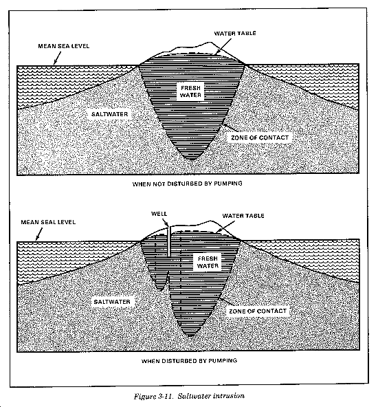
Intrusion. Along coastal areas and on islands, there is always the danger of saltwater intrusion into ground water sources. By analysis, an accurate determination of the degree of salinity can be made. When you discover saltwater intrusion in the ground water supply, take steps to determine the cause (Figure 3-11). When small amounts of fresh water exist on islands and peninsulas, conservation is usually necessary to prevent saltwater intrusion. The amount of fresh water that can be pumped without intrusion of saltwater depends on local conditions, type of well, rate of pumping, and the rate of recharge of the sand by fresh water. In areas of high rainfall, the recharge rate of the sand is usually rapid; but if the rainfall is seasonal, the wells may become dry if you do not ration water during the dry period. A rise in the level of the saltwater occurs if the head (amount) of fresh water is reduced for any reason such as excessive pumping or a decrease in rainfall. The drawdown in the fresh water level around the well causes a rise in the underlying saltwater. Restrict pumping of any one well according to drawdown, for saltwater will enter the well if drawdown is maintained greatly below seal level for extended periods. The pumping rate should not exceed the rate of recharge.
Well Yield and Drawdown
Pumping tests are made on wells to determine their capacity and other hydraulic characteristics and to secure information so that permanent pumping equipment can be skillfully selected and used. Preliminary tests of wells drilled as test holes are sometimes made to compare the yielding ability of different water-bearing formations or different locations in the same formation. Use this information as a basis for selecting the best site for a supply well and the aquifer in which it should be completed. Engineer well drilling units conduct these tests. However, if engineer units do not test the completed well, quartermaster water elements operating the well head must conduct the tests.
Measurements. The measurements that should be made in testing wells include the volume of water pumped per minute or per hour, the depth to the static water level before pumping is started, the depth to the pumping level at one or more constant rates of pumpage, the recovery of the water level after pumping is stopped, and the length of time the well is pumped at each rate during the testing procedure.
Specific capacity. The specific capacity of a well is its yield per foot of drawdown, usually expressed as GPM per foot of drawdown. The specific capacity is not constant for all values of drawdown but is nearly so for wells tapping very thick aquifers and wells operating under artesian conditions. Normally, the specific capacity of a well decreases with increased drawdown. The specific capacity indicates the relative yield of a well.
Pumping Procedures
The pump and power unit used for testing a well should be capable of continuous operation at a constant rate of pumpage for several hours. The equipment must be in good condition for an accurate test, since it is undesirable to have a forced shutdown in the middle of the test. If possible, the test pump should be large enough to test the well beyond the capacity at which it will eventually be pumped, but this may not be practicable under field military operations. For a fairly comprehensive test of a well, first operate the pump at a rate that will lower the water in the well about one-third of the maximum drawdown possible, or about one-third of the capacity of the pump. Continue pumping at this rate until the pumping level remains constant. This will require from one to four hours in most cases. After taking the necessary measurements, change the rate of pumpage to produce two-thirds of the capacity of the pump. Repeat the measurements when the pumping level becomes stable. Increase the rate of pumpage to produce the maximum drawdown, or increase it to the capacity of the pump and make measurements a third time when the pumping level becomes stable again.
Calculations
The drawdown observed during a well test is the difference in feet between the pumping level and the static water level before pumping was started. The specific capacity of the well is the yield or discharge in GPM divided by the drawdown in feet.
DEVELOPMENT OF SEAWATER SOURCES
Factors to be considered in developing seawater sources are surf action, saltwater corrosion, suspended sand and silt in the water, living organisms, surface oil along beaches, and the rise and fall of the water level with the tide. In Arctic regions, another factor is the potential for damage to raw water supply lines from ice floes washing onto the beach. In all regions, locate RO equipment on sheltered bays, harbors, lagoons, or inlets. You can supply raw water by intakes constructed the same as surface intakes for fresh water. On open beaches and small islands, the following intakes can be constructed.
Beach wells are preferred to offshore intakes. Wells can be dug to tap brackish or salt ground water. This eliminates the problems caused by tides, surf, and shallow water close to shore. Another advantage of such wells is that they can be constructed in back of the shoreline under natural overhead concealment. Driven and jetted well points may also be effective at sandy beach locations. A disadvantage is the possibility of high hydrogen sulfate in the raw water, causing fouling problems with RO membranes and taste and odor problems in drinking water.
Offshore Intakes
Offshore intakes are sometimes required due to lack of time, personnel, or equipment required to develop beach wells. Also, coral formations sometimes prevent construction of wells. You can use intakes of either the rigid pipe or float type. If possible, locate either type in deep water beyond the surf action, and place intakes in a vertical position. They also must be off the bottom but beneath the water surface at low tide. In this way, the intakes will keep out foreign matter which may cause wear on purification equipment. Place intake of rigid pipes on supports that are anchored securely in position by pilings. Floats securely anchored can support intake screens the same as they do in surface waters.
Section II
DEVELOPMENT OF WATER POINTS
PURPOSES AND OBJECTIVES
There are a number of purposes and objectives in developing a water point. These are explained below.
A water source developed for military use is called a water point. The development of a water point is the gradual improvement of the water point to increase the quality and quantity of the water and the efficiency of its water treatment and distribution facilities. Orderly development serves to eliminate those bottlenecks and other shortcomings which may occur following the establishment of a water point.
Direct all work done during water point development toward the following six objectives. Unless the work furthers one or more of these objectives, it is unnecessary and should not be done:
- Increase the quantity of potable water available.
- Improve the quality of water produced.
- Lessen storage and distribution problems.
- Decrease site and equipment maintenance needs.
- Improve security of operations.
- Improve living conditions of water point personnel.
PLANS FOR WATER POINT DEVELOPMENT
Proper planning is essential to the orderly development of a water point and should be foremost in the minds of reconnaissance and supervisory personnel. When possible, they should select the site requiring the least improvement. They should prepare a schedule of recommended improvements and follow it. They should give priority to removing obstacles that limit operations. Supervisory personnel at each site need training in water point development.
Order
The relative importance of the problems encountered at each site and the tactical situation determine the order for improvements at water points. For example, in jungle terrain where water is readily available and cover and concealment are good but routes of communication are poor and guerrillas are present, consider distribution facilities and security first. Give priority to those conditions which are necessary to establish the water point and continue water supply operations.
Extent
The extent to which a water point is developed depends primarily on the time, labor, troops, and materials available to do the work. At forward-deployed sites, develop enough to supply potable water to using units. However, in the corps rear area and the COMMZ, the extent of development will vary with the size of the water point, the problems to be overcome, and the permanence of the installation.
SITE IMPROVEMENT CONSIDERATIONS
You must consider a number of factors when improving a site. These are explained in the following paragraphs.
The importance of providing for drainage cannot be overemphasized. Wastewater from treatment units, leakage from tanks, and spillage from distribution facilities keep the area of operation wet. Poor drainage may also cause the area to be so muddy that it becomes unusable. If vehicles cannot get to the point of distribution, the water point no longer serves its purpose. Also, during the winter this water may freeze, causing a serious safety hazard for personnel and equipment. Avoid such conditions by having good drainage at each site. Always direct drainage downstream from the purification, storage, and distribution operations.
Storage Facilities
Storage facilities should be large enough to meet daily peak demands and maintain command-directed DOS. This will eliminate long waits at the water point by consumers and ensure sufficient quantities are available for mission requirements. Water treatment personnel may install collapsible fabric bags to achieve required storage capability. This is in addition to the tanks issued with the purification equipment. Site considerations for these collapsible fabric bags include level (less than 3-degree slope in 100 yards) and clear terrain. Also, you may use existing host nation or occupied country facilities.
Road Networks
A satisfactory water point must be accessible to vehicles and personnel. A good road net with turnarounds, checkpoints, cover, and concealment at the water point and an adequate parking area are desirable features. The load capacity of roads should be sufficient to withstand the heaviest vehicles under all weather conditions. Locate the water point on improved roads whenever possible but avoid main supply routes.
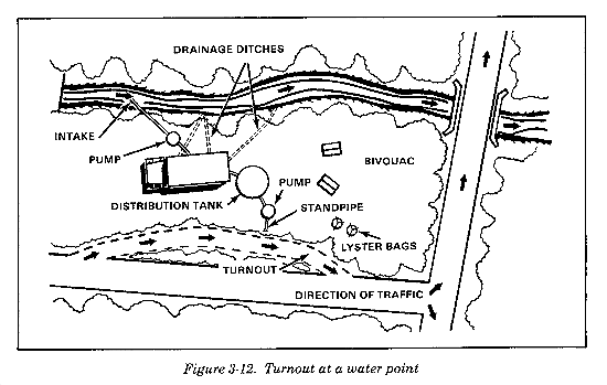
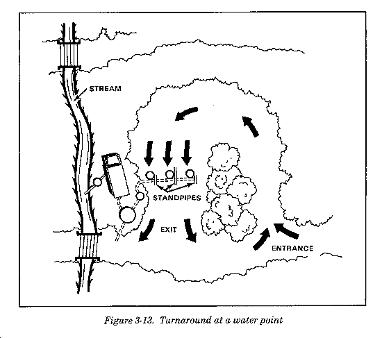
Turnouts and turnarounds. When water points are located along roads, provide facilities for loading consumers' trucks without interfering with normal traffic. A turnout may be a widened section of the main road or a new one-way road past the water point (Figure 3-12). The type used depends on labor and equipment available. For large installations, a turnaround is more convenient and efficient since there is space for water to be distributed to more than one truck at a time (Figure 3-13). Drainage is very important, especially if new construction is required for the turnouts or turnarounds.
Checkpoints. Set up checkpoints at the entrance and the exit of the supply point. Give personnel coming into the area a safety briefing. Use the checkpoints not only to control the traffic but also to monitor logging the issue of water from the supply point.
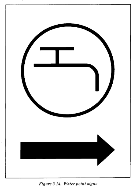
Traffic signs. Water treatment personnel should mark the route to the water point with signs. The signs (Figure 3-14) should be clearly visible to vehicle drivers. Place them so there will be little cross-traffic interference. Also, post them at all critical points within two miles of the water point. Post them at side roads, crossroads, and forks in the road. Place luminous buttons on the signs to help direct vehicles during blackouts. The signs should be made in advance and stored with the water equipment for field use.
Camouflage
Camouflage misleads the enemy by misrepresenting the true identity of an installation, an activity, or an item of equipment. See FM 5-20 for the basic principles of camouflage. The water source may not be within the boundaries of a base or base cluster and, as a result, imposes a special problem of security. The best means of reducing the chances of attack is to deny the enemy any information concerning the location of the water point. This can be done by maximum use of overhead concealment and the use of camouflage nets to distort equipment outlines and shadows. Camouflage nets are particularly applicable for use with the mobile purification units where overhead concealment is lacking. Whenever possible, provide parking areas, turnouts and turnarounds, and all distribution facilities with overhead concealment.
Bivouac
In addition to the other steps involved in developing a water point, select a bivouac area for water point personnel and security forces. In selecting a site, consider security, facilities, sanitation, and comfort of the troops. Although the situation may not permit selection of a site which fully meets all requirements, consider the soldiers' well-being and health. Conveniently locate water supply personnel with respect to the water point. Such a location will facilitate the arrangement of shifts and make personnel readily available in case of emergencies. Locate the bivouac area at least 100 feet away and downstream from the selected water source. See FM 21-10 for field sanitation and other desirable features for bivouac.
Security
Troop morale, welfare, and health depend on a reliable source of potable water. Therefore, commanders must take measures to provide security for water points. A lack of security could result in complete loss of a water point; or the enemy could contaminate storage and distribution facilities, thus disabling or killing those who drink the water. Communication channels to water supply personnel should be kept open. Keep personnel informed of the tactical situation. Provide shelters to protect water supply point personnel from the effects of NBC weapons.
|
NEWSLETTER
|
| Join the GlobalSecurity.org mailing list |
|
|
|