

|
RDL Homepage |
Table of Contents |
Document Information |
LESSON 4
SAUDI ARABIA
Critical Task: None
OVERVIEW
LESSON DESCRIPTION:
In this lesson, you will learn to describe the history, weather, terrain, and LOCs; and identify the military capabilities of Saudi Arabia.
Terminal Learning Objective:
| TASKS: | Describe the history, weather, terrain, and LOCs;and identify the military capabilities of Saudi Arabia. |
| CONDITIONS: | You will be given extracts from CIA World Factbook 1997, DA Pam 550-51, FM 34-72 (Coordinating Draft), and IISS The Military Balance 1990-1991. |
| STANDARDS: | Description of the history, weather, terrain, and LOCs; and identification of military capabilities of Saudi Arabia will be in accordance with CIA World Factbook 1997, DA Pam 550-51, FM 34-72 (Coordinating Draft), and IISS The Military Balance 1990-1991 |
| REFERENCES: | The material contained in this lesson is derived from the following publications: CIA World Factbook 1997. DA Pam 550-51. FM 34-72 (Coordinating Draft). IISS The Military Balance 1990-1991. |
INTRODUCTION
This lesson is an attempt to treat in a concise and objective manner the military aspects of Saudi Arabia. Information used in this lesson was obtained from unclassified sources. Military equipment is in ACCP Subcourses IS3010 and IS3011.
PART A: HISTORY, WEATHER, TERRAIN, AND LOCs OF SAUDI ARABIA
1. General information. Saudi (suh 00 dee) Arabia is a large desert kingdom of mountains, plateaus, and rocky plains which cover three fourths of the Arabian Peninsula in southwestern Asia. The Saudi Arabian landmass is over three times larger than the state of Texas and holds about one fourth of the world's oil reserves. The name of the country in Arabic is Arabyah as-Sa'udiyah, meaning "Kingdom of Saudi Arabia." Riyadh is the capital and largest city. Figure 4-1 is a country outline of Saudi Arabia.
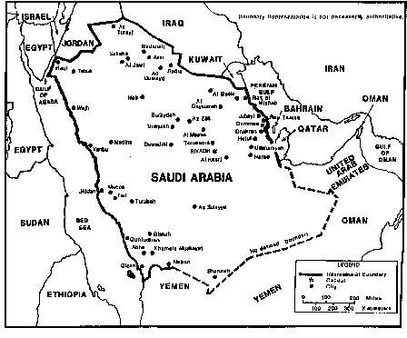
Figure 4-1. Saudi Arabia.
2. Statistical Data.
| Name: | Kingdom of Saudi Arabia |
| Capital: | Riyadh (royal), Jiddah (diplomatic) |
| Population: | 20,087,965 (July 1997) |
| Area: | 1,960,582 |
| Ethnic divisions: | 90% Arab, 10% Afro-Asian |
| Literacy rate: | 62% |
| Religion: | Islam |
| Language: | Arabic |
| GNP: | $ 79 billion |
| Per capita income: | $ 4,800/annum |
| Unit of currency: | Saudi rial (SR) |
| Exchange rate: | $ l - 3.745 SR |
| Time zone: | Solar time - each day begins at sunset when timepieces are reset to 12 am. For example, Sunday night in the West is considered to be Monday evening in Saudi Arabia. For international purposes, time is eight hours ahead of US Eastern Standard Time; three hours ahead of UTC time; time zone CHARLIE |
| Defense forces: | Army, Air Force, Navy, Air Defense, National Guard, and and paramilitary Flag |

Figure 4-2. Flag of Saudi Arabia.
3. History.
a. Historical background.
(1) Recorded civilization in Saudi Arabia dates to 5000 B.C., but until approximately 3000 B.C. the country was only sparsely inhabited. Due to climatic conditions and the desert's slow encroachment upon the land, many of the original people inhabiting Saudi Arabia migrated to other areas of the Middle East. The people of southern Arabia, however, developed a complex commercial network of both land and sea routes and became the middlemen for trade from India and the Horn of Africa. The Indian Ocean trade was carried to Aden by ships and then by overland transportation to the markets of the western Mediterranean coast, Mesopotamia, and Egypt. A slow but inevitable decline in trade began in the fourth century when the Bedouins and other transients of the caravan cities began raiding the trade routes. These raiding wars soon proved too costly for both sides and were ended.
(2) The influence of the prophet Muhammad and the spread of the Islamic faith began about 610 and gained momentum after Muhammad's death in 632.
(3) The Saud clan moved to the Najd Oasis about 1450. Gradually the clan prospered and branches of the clan spread to other parts of the Najd. A series of intermarriages, the most important being clan leader Muhammad bin Sauds to the daughter of Muhammad bin Abd al Wahhab, an Islamic religious leader, cemented the relationship of the clans. By the time of Saud's death in 1765, most of the Najd supported Wahhab. Wahhab renewed his alliance with the new sheik, Abd al Aziz, and together they took the city of Riyadh.
(4) By the time of Wahhab's death in 1792, the Wahhabis had established control south to the Rub al Khali (Empty Quarter) Desert. Tribal feuds were regulated by mediators of the central Wahhabi authority. The area was pacified under the watchful eyes of district governors and deputies stationed in moated forts outside captured towns. The Saudi-Wahhabi were not to rule without clashes, however. In the period of 1824-1834, organized troops ousted the Ottomans who had occupied the Najd. Under Turki bin Abdallah, the integrity of Saudi-Wahhabi rule was protected and oppressive governors who neglected to establish true Islamic rule were dealt with severely.
(5) After Turki's assassination in 1834, Turki's son Faisal took the reins of government. Battles continued for the next century, many of which were between brothes of the ruling families.
(6) Abd al Aziz's tact, personal charm, sense of justice, and deep concern for his people were to be the means with which he would bring the Saudis through conflicts, wars, and compromises to eventual sovereignty. His rule as king of Saudi Arabia lasted until his death in 1953.
b. Recent History.
(1) In 1932 the tribes of the greater portion of the Arabian peninsula were united into the Kingdom of Saudi Arabia. The new kingdom was generally viewed as that of an empty desert region ruled by a warrior family whose members were strict adherents of an orthodox Islamic sect. Saudi Arabia nevertheless possessed significance because of the two holy cities of Islam--Mecca and Medina--and was of interest to international oil companies as an area for oil exploration. Since the discovery of oil in 1938, Saudi Arabia has moved into the position of the world's largest oil exporter. The country's external interest and internal changes have caused a high degree of concern to the rest of the world.
(2) In 1964 Faisal ascended the throne in place of his deposed brother Saud. Faisal was faced with the task of transforming a nearly bankrupt nation with a legacy of tribal attitudes and traditions, into a modern state, while placating the opposing forces of religious conservatism and modernization. By the time of his death in 1975, Faisal had managed to ensure that the vast wealth of his country would be directed toward long term industrial and social welfare programs that would eventually benefit all sectors of the society. These programs also helped to establish Saudi Arabia as a permanent and important power in the Arab world and in the international community. Faisal accomplished all this without seriously offending tribal sensitivities and, at the same time, retained the traditional base of his family's power and the conservative orientation of the society. King Faisal was assassinated in 1975 and was immediately succeeded by Crown Prince Khalid. King Khalid followed many of Faisal's policies in trying to maintain a safe and stable environment in his own country, was well as in the Arab world. The Saudis have built up their military force to protect their own region, and they have provided substantial financial aid to help stabilize other Arab countries. Massive Saudi subsidies have been a great help to Egypt, Jordan, Syria, Oman, Morocco, Sudan, and Somalia. Yemen is a virtual Saudi pensioner.
(3) Saudi Arabia remains one of the most conservative countries of the Arab world. With increasing tensions in the area in the past few years, the Saudi royal family has concentrated efforts on the internal security of the country.
(4) In August 1990, Saudi Arabia felt threatened by the Iraqi invasion of Kuwait and asked the US to assist them in their effort to deter Iraqi forces from entering Saudi Arabia. US and multinational troops were rushed into Saudi Arabia. On 23 February 1991, the ground war started and within 100 hours Kuwait was liberated by US and multinational forces including Saudi Arabian troops.
(5) Political reforms decreed by King Fahd in 1992 established a consultative council to serve in an advisory capacity, provided for a bill of rights, and changed the rules of succession. The consultative council, called the Shura Council, was convened for the first time in December 1993. Social reforms ere less evident, however. In 1993 Saudi authorities disbanded a committee for the protection of human rights, which relocated to London the following year. As of 1994, Saudi men and women were not permitted to attend public events together, and workplaces remained segregated. Government officials in the United States voiced continuing concern about human rights violations in Saudi Arabia, particularly the abuse of prisoners by guards and police.
(6) King Fahd remained an active sponsor of Islamic causes worldwide in his second decade as Saudi leader. In 1992 Fahd conducted an extensive campaign to end the bloodshed in the former Yugoslav Republic of Bosnia; his efforts included a national fund-raiser to provide aid to Bosnian Muslims, to diplomatic links with the Muslim Republics formerly included in the Union of Soviet Socialist Republics: Tajidistan, Turdmenistan, and Uzbekistan. In January 1994, Palestine Liberation Organization Chairman Yasir Arafat visited Riyadh to discuss with King Fahd the prospects for Middle East peace. The meeting represented a significant reestablishment of relations between the two leaders, whose relations had been strained since the Persian Gulf War. In March 1991, Fahd chose not to receive Jordan's King Hussein, who was visiting Mecca for the annual haj (pilgrimage). Relations between the Arab leaders had been unfriendly due to Jordan's support for Iraq during its invasion of Kuwait.
(7) In February 1995 the governments of Saudi Arabia and Yemen agreed to negotiate a settlement to their long-standing dispute over their shared border; the agreement followed several months of small-scale fighting in the border region. As of May 1996 the two countries had not decided on a formal border. After suffering a stroke in November 1995, Fahd gave control of the country to his half-brother, Crown Prince Abdullah, in January 1996. In February, however, Fahd reclaimed his authority.
4. Weather.
a. Climate.
(1) Saudi Arabia's predominately arid climate is characterized by extreme heat during the day, an abrupt drop in temperature at night and by periods of slight and erratic rainfall (Table 43). Because of the influence of a prevailing sub-tropical high-pressure system and the many fluctuations in elevation, temperature and humidity vary considerably.
(2) Along the coastal regions of the Red Sea, a sub-tropical climate exists in the south and a semi-arid climate prevails in the north. The summer, at 10 months, is the longest season of the year and the temperatures are often tempered by sunset sea breezes. Winters are mild and are comparable to the spring and summer season of the Mediterranean Sea coasts. Around Jiddah and northward along the coast, rainfall is infrequent except for a period of heavy rainstorms between November and February. The area south of Jiddah in the Asir range is subject to Indian Ocean monsoons, which occur between October and March. These monsoons produce an average of 30 cm rainfall out of an annual total of 50 to 76 cm.
(3) In eastern Saudi Arabia long the Persian Gulf, the climate is more desert-like. The summer is seven months long with July and August being extremely hot. The annual rainfall of only 8 to 18 cm is usually concentrated in heavy showers during November and February.
(4) Both the Red Sea and Persian Gulf coasts have relatively high humidity, usually over 85% and frequently reaching 100%. The combination of warm air and high humidity produces a hot mist during the day and a warm fog at night. The prevailing winds are generally from the north. The presence of the winds makes the coastal areas more bearable in the summer and even pleasant in the winter. A southerly wind accompanied by an increase in temperature and humidity produces a particular kind of storm known in the Persian Gulf area as "kauf." In late spring and early summer, a strong northwesterly wind known as the "shamal" creates severe conditions in eastern Arabia with sand and dust storms that often reduce visibility to a few feet.
(5) A uniform climate prevails in the Najd and the great deserts. The heat becomes intense shortly after sunrise and lasts until sunset. This is followed by comparatively cool nights. In the winter the almost total absence of humidity and presence of a high wind-chill factor produce a bitterly cold atmosphere. For these portions of the country, rainfall is minimal and erratic. The entire rainfall may be the product of one or two torrential outbursts that flood the wadis and then rapidly disappear into the soil to be trapped above the layers of impervious rock. Although the average desert area rainfall is 10 cm, whole regions may not experience rainfall for several years. Dust storms are common throughout Saudi Arabia with some sandstorms lasting up to four days.
Table 43. Annual temperatures.
|
b. Light tables. Light tables reflect the average times, by month, for sunrise and sunset. At the times shown in Table 44, general outlines may be visible; but the horizon is not likely to be distinguishable.
Table 44
RIYADH, SUADI ARABIA
SUNRISE
SUNSET
|
5. Terrain.
a. Terrain features.
(1) Saudi Arabia occupies approximately 75% of the Arabian Peninsula, an area equivalent to the US east of the Mississippi. Since the country's boundaries are generally undefined, its exact size is unknown. The Saudi Arabian landmass has 98% desert, waste, or urban; 1% agricultural; and 1% forest. The country is bounded by eight countries and three bodies of water; to the west by the Gulf of Aqaba, the Red Sea, and Yemen; to the north by Jordan, Iraq, and Kuwait; to the east by the Persian Gulf, Bahrain, Qatar, and the United Arab Emirates; and to the south by Oman and Yemen. Saudi Arabia is divided into five regions; the mountain ranges of Hejaz and Asir, the plateau area of the Najd, northern Arabia, Al Hasa (eastern Arabia), and the deserts (Figure 4-3). Trafficability in Saudi Arabia is evaluated in Table 45.
(2) The mountain ranges of Hejaz and Asir parallel the Red Sea. The two ranges are separated by a gap in the vicinity of Mecca. The northern range, seldom exceeds 2,134 m and the elevation gradually decreases to about 610 m in the south around Mecca. The mountain wall is rugged, dropping abruptly to the sea, and has few and intermittent coastal plains. natural harbors are rare along the Red Sea coast. The western slopes have been stripped of soil by the erosion of infrequent, but turbulent rainfalls that have fertilized the plains to the east. The eastern slopes are less steep and are shaped by wadis that mark the courses of ancient rivers and provide a rain runoff through leading to the plains. Scattered oasis drawing water from springs and wells in the vicinity of these wadis permit some permanent agriculture. Of these, the largest and most important is the Medina Oasis.
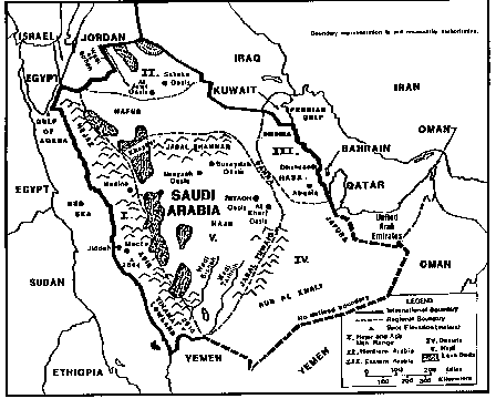
Figure 4-3. Terrain features/natural regions of Saudi Arabia.
Table 45. Trafficability.
|
(3) In the Asir Range south of Mecca, the mountains are higher, exceeding 2,500 m with some peaks reaching over 3,000 m. The rugged western face of the escarpment drops rather steeply to the coastal plain (the Tihama Lowlands), which averages only 64 km in width. The top of the mountain ridge is covered in places by narrow strips of juniper trees which provide the only natural forest in the country. Luxuriant undergrowth gives these strips--many only a few meters wide--the character of a tropical rain forest.
(4) The eastern slope of the mountain range is gentle, melding into a plateau region that drops gradually into the Rub al Khali, one of the most forbidding sand deserts in the world and, until the 1950s, one of the least explored. Rainfall is infrequent in this area; but a number of fertile wadis, chiefly the Bishah and the Tathlith, do exist. Extensive lava beds (harrat) scar the surface of the plateau east of the mountain ranges of the Hejaz and Asir Ranges, wells are abundant and springs are common in the mountainous areas.
(5) The great plateau of the Najd, the heartland of the country, lies east of the Hejaz and Asir. This region is mainly a rocky plateau interspersed with small, sandy deserts and isolated mountain clumps. The best known of the mountain groups is the Jabal Shammar, northwest of Riyadh and just south of the Nafud Desert. The plateau slopes towards the east from an elevation of 1,372 m in the east. A number of wadis cross the region in a generally eastward direction from the Red Sea escarpment toward the Persian Gulf. The heart of the Najd is the area of the Jabal Tuwaiq, an arc-shaped ridge whose steep west face rises to between 122 and 244 m above the plateau. Many cases exist, making this one of the most densely populated areas in the country. The oasis of Buraydah, Unayzah, Riyadh, and Al Kharj are the most populated. Outside this oasis area the Najd is sparsely populated. Sabkahs, large salt marshes, are scattered throughout the area, and water is available in few places. Even where water is plentiful, the quality is generally poor.
(6) Northern Arabia comprises the area north of the Nafud Desert and is geographically a part of the Syrian Desert. The area is an upland plateau with a surface of dark-colored rock and gravel and is scored by numerous wadis, most of which run northeastward toward Iraq. This area, known as Badiet ash Sham, is covered with grass and scrub steppe vegetation and is extensively used for pasture by nomadic and seminomadic herders. The most significant feature of the area is the Wadi as Shirhan. This is a large basin, as much as 305 m below the surrounding plateau, that is the remnant of an ancient inland sea. For thousands of years some of the most heavily traveled caravan routes between the Mediterranean and the central and southern peninsula have passed through the Wadi as Sirhan. The most important cases in the area are Al Jawf and Sakaka, just north of the Nafud.
(7) Eastern Arabia (Hasa) consists of the rocky Summam Plateau, east of the Dahna Desert. The plateau is about 120 km wide and drops in elevation to about 245 m in the east. The area is generally barren and has a highly eroded surface of ancient river gorges and isolated buttes. Farther east the terrain changes abruptly to the flat lowlands of the Persian Gulf coastal plain. This area, about 160 km in width, has no significant terrain features and is generally covered with gravel or sand. The gravelly Dibdiba Plain lies to the north. To the south is the Jufura sand desert. The Jafura reaches the Persian Gulf in the vicinity of Abqaiq and Dhahran and merges with the Rub al Khali at its southern end. The coast itself is extremely irregular as sandy plains, marshes, and salt flats merge almost imperceptibly with the sea. As a result, the land surface is unstable; water rises almost to the surface in places and the sea is shallow and full of shoals and reefs for an extended distance offshore. Only the construction of long rock breakwaters at Ras Tanura has opened the Saudi Persian Gulf coast to seagoing tankers. Eastern Arabia is one of the most potentially fertile areas of the country. Water from artesian wells and springs is plentiful and there are also a number of large deep pools that are constantly replenished by artesian springs.
(8) Three great deserts isolate the Najd from the north, east, and south, as does the Red Sea escarpment from the west. In the north the Nafud Desert--sometimes called the Great Nafud--covers about 65,000 km2 at an elevation of about 900 m. Longitudinal dunes which are approximately 60 to 80 km in length, some 90 m in height and separated by valleys as wide as 16 km characterize the Nafud. Iron oxide gives the sand a reddish tint, particularly when the sun is low. There are several watering places in the area, and winter rains bring up short lived, but succulent grasses that permit nomadic herding during the winter and spring.
(9) The Dahna is a narrow band of sand mountains (also known as the river of sand) which stretches more than 645 km south from the Nafud in a narrow arc about 50 km wide. Its sand also tends to be reddish in color, particularly in the north where it shares the longitudinal structure of sand dunes with the Nafud. The Dahna furnishes the Bedouin with winter and spring pasture although water is more scarce than in the Nafud. The southern portion of the Dahna curves westward following the arc of the Jabal Tuwaiq and merges in the south with the Rub al Khali. The topography of the Rub al Khali covers more than 650,000 km2 and is varied. In the west the elevation is about 610 m and the sand is fine and soft; in the east the elevation drops to about 185 m and much of the surface is covered by relatively stable sheets of sand and salt flats. Longitudinal sand dunes prevail, particularly in the east. Elsewhere, sand mountains as high as 300 m form complex patterns. Most of the area is totally waterless and uninhabited except for a few wandering Bedouin tribes. Water, which generally must be pumped or hoisted to the surface, is available in limited quantities in widely separated areas of the Dahna.
b. Urban area.
(1) Saudi Arabian towns and cities historically fall into two major categories--those inside and those outside the Hejaz. The holy cities of Mecca and Medina and the diplomatic capital of Jiddah all fall within the Hejaz. These Hejaz cities are the largest in the country after the capital of Riyadh and are composed of people from many parts of the world (Table 46). These cities have experienced the effects of Saudi oil discovery less than the more conservative cities of the central and eastern regions.
Table 46. Urban area.
|
(2) The huge influx of wealth and people into old towns like Riyadh, Buraydah, and Unayzah has transformed these traditional family-centered communities into congested melting pots of workers representing many cultures. The presence of foreigners, and the wealth they represent, has put serious strains on housing facilities, price levels, and public services in general, as well as on the traditional aspects of the Islamic way of life. Foreigners in the major cities usually live in their own separate communities, but must respect Saudi religious and social customs.
c. Coasts and beaches. Saudi Arabia has 2,510 km of coastline. It declares 12 nm as a "necessary supervision zone." The country also claims many small islands as well as some seabeds and subsoils beyond the 12nm limit. While maritime boundaries with Bahrain, the island state off Saudi Arabia's northeastern coast, have been agreed upon, claims with other Saudi neighbors along the Persian Gulf including Iran are in an almost constant state of negotiation and adjustment. Coast and beach access to Saudi Arabia is evaluated in Table 47.
Table 47. Coast and beach access.
|
6. LOCs. Transportation facilities have increased dramatically in the last 15 years; however, services are still inadequate to meet the country's economic and human needs.
a. Roads. The road system has undergone tremendous expansion in recent years. The government plans to continue expansion on the roads. Saudi Arabian roads which are built according to American standards are constructed to support loads of 16 tons. Widths vary from 6 to 9 m. Due to road use by vehicles with loads exceeding the tonnage limit, early road rehabilitation is required. Table 48 identifies the road network. Figure 4-5 and Table 49 depict and locate the main routes.
Table 48. Road network.
|
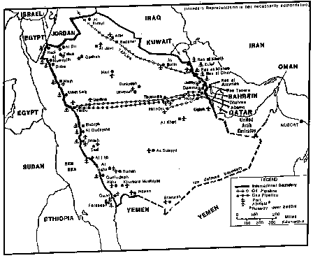
Figure 4-4. Ports, airfields, and pipelines of Saudi Arabia.
Table 49. Roadways.
|
b. Railroads. Only one railroad line exists in Saudi Arabia, from Damman to Riyadh. Table 50 identifies the Saudi rail network. Table 51 identifies the main routes. A line linking Jiddah and Mecca is planned, mainly to carry pilgrim traffic. The old Hejaz Railway which connected Amman, Jordan with medina is now derelict; sporadic efforts have been made to rebuild the line. Figure 4-5 locates the railroads.
Table 50. Railroad network.
|
Table 51. Main railway routes.
|
c. Ports. Saudi Arabia's main ports are Jiddah and Yanbu on the Red Sea and Ras Tanura, Dammamm and Jubayl on the Persian Gulf. Table 52 provides a list of major ports and their capabilities. Minor ports are identified in Table 53. Figure 4-4 identifies all port locations.
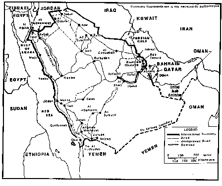
Figure 4-5. Roads and railroads of Saudi Arabia.
Table 52. Major ports.
*Includes fuel, fresh water, and food. |
Table 53. Minor ports.*
Red Sea
*Suitable for small craft only. |
d. Air transportation. Air is the preferred method of travel in order to minimize the vast distances between the country's population centers. Table 54 identifies the air network. The primary international airports are at Riyadh, Jiddah, and Dhahran with numerous smaller airports and landing areas scattered throughout the area. Table 55 and Figure 4-4 identify and locate the main airfields. The government-owned Saudi Arabian Airlines, the largest airline in Southwest Asia, is headquartered in Jiddah and provides regular services to all major cities.
e. Water transportation. Saudi Arabia has no permanent rivers or bodies of water.
f. Pipelines. Saudi Arabia's pipeline network is identified in Table 56. Saudi's pipeline system consists of both domestic and international pipelines (Figure 4-4). The pipeline network collects crude oil from production area, including those offshore, and carries it to the refining and shipping terminals at Ras Tanura and Jubayl (Figure 4-6). Saudi Arabia is considering a spur line from the Trans-Arabian Pipeline (TAPLine) to the Red Sea port of Duba and a pipeline from the Persian Gulf fields through Oman providing an Indian Ocean terminal. The Saudis objective is to lessen their dependency on the shipping lanes through the Strait of Hormuz.
NOTE: There are several desalination plants along the Persian Gulf and Red Sea coasts. These plants extract fresh water from salt water. Above and below ground pipelines are used to transport fresh water from the plants to distribution points.
Table 54. Air transportation network.
*Runway lengths are for paved and unpaved usable airfields only. |
Table 55. Airfields.*
*Runway length 2,440m or longer |
||||||||||||||||||||||||||||||||||||
|
Table 56. Pipeline network.
|
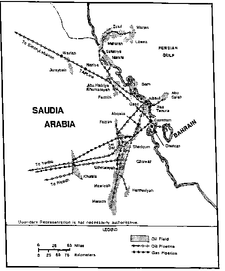
Figure 4-6. Persian Gulf pipelines.
PART B: MILITARY CAPABILITES OF SAUDI ARABIA
1. Background. In 1944 King Abd al Aziz created the office of the Minister of Defense as the first formal organization responsible for the development of the armed forces in Saudi Arabia. However, the present Ministry of Defense and Aviation was not established until 1953. When Faisal became King in 1964, he reorganized the entire military system along present day lines. The Saudi Armed Forces have received combat experience in the Yemeni Civil War, the June 1967 and October 1973 Arab-Israeli wars, and in Operation Desert Storm as part of the multi-national forces in their effort to oust Iraqi troops from Kuwait and the northern part of Saudi Arabia.
2. Command. The Armed Forces defense structure is headed by the king who is also the Commander in Chief of the armed forces. His brother is the Minister of Defense and Aviation (Figure 4-7).
3. Armed Forces. The branches of the Armed Forces include Army, Air Force, Navy, Air Defense, National Guard (White Army), and paramilitary forces. The armed forces are assigned to safeguarding the integrity of the national boundaries and seaward frontiers. In times of internal disorder, they also have a responsibility for maintaining the internal security of the kingdom. The National Guard has exclusive control of the oil-producing eastern province and the general mission of supporting the Armed Forces in maintaining internal security. The National Guard is also used to assist the regular Armed Forces in repelling an invasion; however, its most important, if unstated, mission is to suppress military insurgencies. Special anti-insurgency units are maintained within both the National Guard and the regular army.

Figure 4-7. Saudi Armed Forces command structure.
a. The Saudi Army consists of volunteers. It is the Army's mission to defend the country. Army units are listed in Table 57. The army has expanded rapidly from some 40,000 in the late 1980s to around 70,000 today. Nonetheless, the current force structure is undermanned by 20-30%. In 1991, a joint US-Saudi review proposed an expansion to between seven and nine divisions but this was over-ambitious. Current Saudi plans appear to call for the creation of five divisions, instead of the current brigade structure, which would increase total army manpower to some 120,000 men.
Table 57. Saudi Army units.
|

Figure 4-8. Saudi airborne brigade.
b. The Saudi Air Force consists of volunteers also. It is the air force's mission to conduct independent air attacks against enemy targets, participate in the defense of the country against hostile air action, and support the army and navy by air strikes, reconnaissance, air resupply, and transport (Table 58). Bases are at Jubayl, Khamais Mushayat, King Khalid, Najran, Qizan, Riyadh, Sharurah, Tabuk, and Thumama (Table 55 and Figure 4-4).
Table 58. Saudi Air Force units.
|
Copyright: Reprinted from The Military Balance 1990-91, IISS (London).
c. The Royal Navy will be reorganized and improved in the wake of recent developments in the region, including the emergence of a submarine threat and the perceived threat from extreme fundamentalism on the other side of the Red Sea. The Saudi Navy consists of volunteers. Most are assigned to naval vessels (Table 59). Bases are at Riyadh (HQ) Jiddah, Yanbu, Jubayl, Dammam, Ras al Mishab, and Ras al Ghar (Figure 4-4). Furthermore, there is 1 x Marine infantry regiment attached to the navy.
Table 59. Saudi naval equipment.
|
d. The Saudi Air Defense Forces is also a separate command under the Chief of Staff. It has approximately 33 x surface-to-air (SAM) batteries. Furthermore, the Saudis bought the first of six Patriot missile batteries in September 1990 and completed delivery by 1993.
e. The Saudi National Guard is directly under royal command (Table 60).
Table 60. Saudi National Guard
| 2 x Mechanized infantry brigades each with 4 x all arms battalions 2 x Infantry brigades (2 x more are forming) 1 x Cavalry squadron (ceremonial) |
f. Paramilitary forces consist of a Frontier Force including the Coast Guard with 400 x boats and 24 x hovercraft, General Civil Defense Administration units with 10 x helicopters, and a Special Security Force with 500 x UR-410 APC.
g. Saudi Armed Forces manpower is shown in Table 61.
Table 61. Saudi Armed Forces Strength.
|
Copyright: Reprinted from The Military Balance 1990-91, IISS (London).
Practice Exercise