

|
RDL Homepage |
Table of Contents |
Document Information |
LESSON 3
KUWAIT
Critical Task: None
OVERVIEW
LESSON DESCRIPTION:
In this lesson, you will learn to describe the history, weather, terrain, and LOCs; and identify the military capabilities of Kuwait.
Terminal Learning Objective:
| TASKS: | Describe the history, weather, terrain, and LOCs; and identify the military capabilities of Kuwait. |
| CONDITIONS: | You will be given extracts from CIA WorldFactbook 1997, DA Pam 550-185, FM 34-72 (Coordinating Draft), and IIIS The Military Balance 1990-1991. |
| STANDARDS: | Description of the history, weather, terrain, and LOCs; and identification of military capabilities of Kuwait will be in accordance with CIA World Factbook 1991, DA Pam 550-185, and FM 34-72 (Coordinating Draft), and IISS The Military Balance 1990-1991. |
| REFERENCES: | The material contained in this lesson was derived from the following publications: CIA World Factbook 1997. DA Pam 550-185. FM 34-72 (Coordinating Draft). IISS The Military Balance 1990-1991 |
INTRODUCTION
This lesson is an attempt to treat in a concise and objective manner the military aspects of Kuwait. Information used in this lesson was obtained from unclassified sources. Military equipment is in ACCP Subcourses IS3010 and IS3011.
PART A. HISTORY, WEATHER, TERRAIN, AND LOCs OF KUWAIT
1. General Information. Kuwait (koo WAIT) is a small Arab country in southwestern Asia, at the north end of the Persian Gulf. This desert land is one of the world's leading petroleum producers. Kuwait is slightly larger than the state of Connecticut. The country's official name is the State of Kuwait and Arabic is the official language. The city of Kuwait is the capital and largest city. Figure 3-1 is a country outline of Kuwait.

Figure 3-1. Kuwait.
2. Statistical data.
| Name: | State of Kuwait (Daulat al Kuwait) |
| Capital: | Kuwait City |
| Population: | 1,834,269 (July l997) |
| Area: | 17,829 km2 |
| Ethnic divisions: | 27.9% Kuwaiti, 39% other Arabs, 9% South Asian, 4% Iranian, and 20% others |
| Language: | Arabic, English commonly used |
| Literacy rate: | 74% |
| Religion: | 85% Muslim; 5% Christian, Hindu, and others |
| GNP: | $ 19.8 BILLION |
| Per capita income: | $ 9,700/annum |
| Unit of currency: | Kuwaiti dinar (KD) |
| Exchange rate: | $ 1 - .29 KD |
| Time zone: | Three hours ahead of UTC, eight hours ahead of US Eastern Standard Time; time zone CHARLIE |
| Defense forces: | Army, Air Force, Navy, and paramilitary forces |
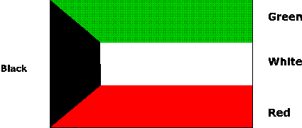
Figure 3-2. Flag of Kuwait.
3. History.
a. Historical background.
(1) Kuwait began as a small fishing and trading settlement along the northern coast of the Arabian Peninsula. From about 4000 to 2000 B.C., this region controlled the Persian Gulf route to the East Indies and was the trading link between the civilizations of the Indus Valley and Mesopotamia. Traders enriched the first civilizations in Mesopotamia, both commercially and culturally. Because of its distance from Mesopotamia, Kuwait was not affected by the continuous upheavals experienced by other areas of Southwest Asia.
(2) During the early 1700s, drought and famine caused mass migrations of Arab tribes to the north coastal lands of the Persian Gulf, presently the site of Kuwait. The Utub tribe migrated from Saudi Arabia in the 18th century and settled in a small town which they called Kuwait (fortress built near water), finding the mild climate a welcome change from the harsh desert. From the Utub tribe emerged the founders of present-day Kuwait.
(3) Kuwait came under British rule in 1889, at the time when British influence was displacing the Ottoman Empire. Britain assumed responsibility for Kuwait's foreign affairs and provided protection from foreign intervention. Until the end of World War II, Kuwait was a poor, traditional kingdom whose people earned their living from fishing, pearling, and trading with Persian Gulf neighbors. After the war they began to exploit the oil that had been discovered in 1938. Britain no longer needed Kuwait as a military frontier, and the increased oil income and stabilization of Kuwait's internal rule enabled the British to grant independence on 19 June 1961.
b. Recent history.
(1) Since the attainment of full independence in 1961, the most significant political innovation has been the increased power and prestige of the popularly elected assembly. Furthermore, Kuwait is the only state on the Arabian peninsula that has established a modern legal system. By the 1970s Kuwait boasted the world's highest per capita income and a system of social services including public education, free medical care, government housing, and pensions. The enormous wealth derived from Kuwait's oil resources has financed the remodeling of government services, upgraded the armed forces, improved the physical development of the state's infrastructure, and has stimulated foreign investment.
(2) The "oil boom" caused a significant migration of foreigners to Kuwait initially creating a major problem for the government. Strict naturalization laws, however, prevented these noncitizens had increased to 50% of the total population, and the government realized that the skills and manpower of the immigrants were essential for Kuwait's economic development. The Kuwaiti Government subsequently liberalized the naturalization laws and granted citizenship to a larger number of immigrants.
(3) At the Baghdad Summit in November l978, Kuwait pressed for a consensus among the Arab nations condemning the Israeli-Egyptian peace agreement. By the 1980's Kuwait had adopted an active role in preserving Arab unity and along with Saudi Arabia, emerged as one of the Persian Gulf's dominating forces. Kuwait had some success in the role of mediator in the conflict between the People's Democratic Republic of Yemen and the Yemen Arab Republic. Kuwait was also instrumental in resolving a crisis in the United Arab Emirates (UAE).
(4) Kuwait supported Iraq in its war with Iran by contributing billions of dollars to the Iraqi war effort. However, Saddam Hussein threatened Kuwait with a takeover, unless Kuwait would join Iraqi efforts to raise oil prices. In August 1990, Iraqi troops invaded Kuwait and devastated this country, forcing about half the population to flee to Saudi Arabia. The United Nations passed 12 resolutions and urged Iraq to leave Kuwait by 15 January 1991, but to no avail. United States and multinational troops were rushed into Saudi Arabia in response to an urgent call from the rulers of Kuwait and Saudi Arabia. On 16 January 1991, the Gulf War started with thousands of bombing raids. On 23 February 1991, the ground war started and within 100 hours Kuwait was liberated. As the Iraqis retreated, much of Kuwait's industry, infrastructure, and buildings were destroyed. Among the most heavily damaged were places of the royal family, government and other public buildings, oil wells, and roads. Since the war, Kuwait has been largely rebuilt. It will still take some years to repair the damage to the infrastructure and especially to repair the Iraqi destructions of the Kuwaiti petrochemical industry.
4. Weather.
a. Climate.
(1) The climate of Kuwait is somewhat less severe than in other parts of the Persian Gulf (Table 30). Intense humidity occurs in August. Sand and dust storms are frequent in the summer when the "shamal," a strong northeast wind, blows down the gulf from Iraq. The winter period from November to April is generally pleasant due to the abundance of sunshine; however, there can be periods of raw weather with cold temperatures and rather heavy rain (i.e., Desert Shield/Desert Storm).
(2) Rainfall varies from 8 to15 cm a year throughout the country. Some years, however, actual rainfalls have ranged from 2.5 cm to as much as 33 cm with most of the rain falling during the winter months. Sea temperatures in the summer rise to over 32° in August, increasing the humidity on the coastal lowland. Further inland the climate is more favorable due to stronger winds and lower humidity.
Table 30. Annual Temperatures.
|
b. Light tables. Light tables reflect the average times by month of sunrise and sunset. At the times shown in Table 31, general outlines of the horizon may be visible but ordinarily cannot be distinguished.
Table 31. Light Table.
KUWAIT, KUWAIT
SUNRISE
SUNSET
|
5. Terrain.
a. Terrain features.
(1) Located at the northwestern corner of the Persian Gulf, Kuwait is bounded on the east by the Persian Gulf, on the north and west by Iraq, and on the south and southwest by Saudi Arabia (Figure 3-3). The area of the state is about 17,829 km2 including offshore islands. There are a number of offshore islands, the largest of which is Bubiyan, separated from the mainland by a narrow waterway, Khawr al Sabiyah. The country's only prominent geographic feature is Kuwait Bay, which indents the shoreline for about 40 km and provides natural protection for the port of Kuwait.
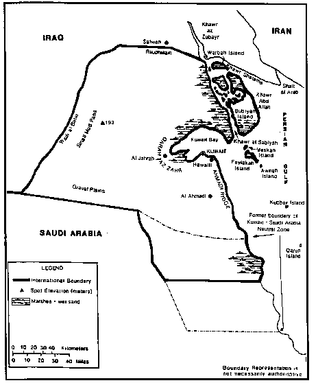
Figure 3-3. Terrain Features of Kuwait.
(2) The northern border with Iraq was secured through an agreement with Turkey in 1913. Although the agreement was never formally ratified, it was accepted by Iraq in 1932. In the 1960s and 1970s Iraq made various attempts to claim the Kuwait territory. The boundary with Saudi Arabia was set by the Treaty of Uqair in 1922, which also established the 5,700 km2 Kuwait-Saudi Arabia Neutral Zone. In 1966 Kuwait and Saudi Arabia divided the neutral zone and in 1969 each country became responsible for its own portion of the zone. A 3,520 km2 neutral zone had been established west of the quadripoint with Iraq, Kuwait, and Saudi Arabia, that had been jointly administered by Iraq and Saudi Arabia. In December 1981, Iraq and Saudi Arabia signed an agreement to divide the zone between them, but the agreement was not ratified. However, since Desert Shield began, all maps have eliminated this zone. Boundaries are now aligned along the facto boundary that divides the zone through the middle.
(3) Most of Kuwait consists of desert. There is one small oasis, Al Jahrah, at the western end of Kuwait Bay and a few water wells in the coastal villages. The Wadi al Batin, a broad shallow valley, forms the western boundary of Kuwait. At Raudhatain in the north, several shallow wadis converge the area and provide a temporary repository for winter floodwaters which quickly evaporate or are absorbed into the porous subsoil. There is a continual redistribution of topsoil caused by flood runoff and erosion.
(4) The Kuwaiti desert is undulating and gravelly with a few low hills or ridges like the Qarah az Zahr scarp west of Kuwait Bay. The 18 km-wide coastal plain is separated from the central part of the country by the 120 m-high Ahmadi Ridge that runs north and south. The only trees, aside from those in the date gardens at Al Jahrah, are tamariks in Kuwait City and a few nearby villages. Arfaj, the most common desert shrub, grows in the vicinity of the Wadi al Batin. It reaches a maximum height of slightly over .5 m and is used for firewood by nomadic tribesmen.
(5) Kuwait has numerous islands within its territorial waters. Warbah Island is a low-lying land mass which is separated from Iraq by the narrow Khawr Shatama channels. The island is 13 km long and is covered by rough grasses and reeds. Bubiyan Island lies south of Warbah and is separated from the Kuwait mainland by the Khawr al Sabiyah channel. The island is 43.5 km long and 25 km wide and has low terrain and swampy shores. The northwestern portion of Bubiyan is partly submerged at high tide and there is a mud flat which extends southeast of the island. The islands of Faylakah and Maskan are located on this mud flat. Faylakah is low and sandy; it is 11 km long by 5 km wide and is the only island that is inhabited. Maskan, Awhah, Kubbar, and Qaruh are quite small, and Kuwaiti ownership of Qaruh is disputed by Saudi Arabia. Trafficability in Kuwait is discussed at Table 32.
Table 32. Trafficability.
|
b. Urban area.
(1) Overlooking Kuwait Bay is Kuwait City--capitol, chief port, and commercial center of the country. Half of the country's population lives in Kuwait City and its suburbs, which include the town of Hawalli. The metropolitan appearance of this modern city is in remarkable contrast wit the surrounding desert. The city extends 24 km along the south side of Kuwait Bay and 10 km inland; it forms a concentric pattern from the original main gate of the old city. Trees and shrubs have been planted in the city and the surrounding suburbs as part of a program that seeks not only to beautify but to screen the metropolitan area against summer sandstorms.
(2) The only other town of major note is Al Ahmadi, the headquarters of the Kuwait Oil Company.
c. Coast and beaches. Kuwait has 499 km of coastline, 212 km on the mainland, and 287 km on the outlying islands. The beachfront along Kuwait Bay is excellent and accounts for 40 km of the mainland coastline. The sandy southern portion of the coast is in direct contrast to the swampland found to the north of Al Jahrah. The country's territorial waters extend 12 nm. Coast and beach access to Kuwait is discussed in Table 33.
Table 33. Coast and beach access.
|
6. LOCs.
a. Roads. Kuwait has a well-developed road network that links the urban areas and oil fields. Tables 34 and 35 show the road network and main routes. Figure 3-4 locates the LOCs. A four-lane highway is under construction to upgrade the present route to Riyadh, Saudi Arabia via Damman. A 2.4 km bridge from Sabiyah to Bubiyan Island is in the planning stages.
b. Railroads. Kuwait does not have a rail network.
Table 34. Road network.
|
Table 35. Roadways.
|
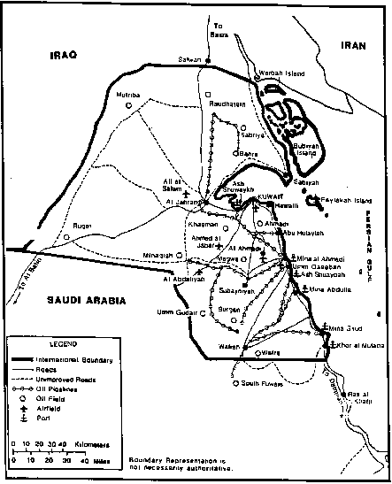
Figure 3-4. Roads and Pipelines of Kuwait.
c. Ports. Kuwait has three major ports located at Ash Shuwaykh, Ash Shuaybah, and Mina al Ahmadi. A lesser port is located at Khor al Mufatta, and two oil terminals are at Mina Abdulla and Mina Saud. Figure 3-4 identifies their locations, and Table 36 lists Kuwaiti ports and their capabilities. Kuwait shipping services provide primarily petroleum and cargo services.
d. Air transportation. Kuwait has its own airline--Kuwait Airways Corporation--headquartered at the Kuwait International Airport in Kuwait City. The air transportation network is depicted in Table 37. Key airfields are identified in Figure 3-4 and Table 38.
e. Water transportation. Kuwait has no inland waterways or bodies of water.
f. Pipelines. The pipeline network is depicted in Figure 3-4.
Table 36. Ports.
* Includes fuel, fresh water, and food. |
Table 37. Air transportation network.
NOTE: Runway lengths are for paved and unpaved usable airfields only. |
Table 38. Airfields
|
PART B: MILITARY CAPABILITIES OF KUWAIT
1. Background. The Kuwaiti Armed Forces were formed with British assistance after World War II. Occasional border difficulties with Iraq and concern for Kuwaiti independence were causes for continuous expansion of the Armed Forces. Over the years Kuwait has modernized its Armed Forces by purchasing equipment from a variety of nations. The armed forces have had to be rebuilt from the debacle of the Iraqi invasion and have declined from a total strength of 20,300 before the invasion to an estimated 15,300 in 1996. The chief of staff stated in 1996 that the emirate was at least three to five years away from achieving its objective of being able to counter an Iraqi incursion. Re-equipment has involved new aircraft for the air force, new patrol craft and new tanks and personnel carriers for the ground forces. As late as January 1997 Kuwait claimed that Iraq still holds hundreds of millions of dollars worth of captured Kuwaiti equipment.
2. Command structure. The defense structure is headed by the EMIR, who is Commander-in-Chief. The line of command runs through the Chief of Staff and the Deputy Chief of Staff, both of whom are princes of the Al-Sabah royal family (Figure 3-5).
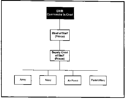
Figure 3-5. Kuwaiti Armed Forces command structure.
3. Armed Forces. The primary mission of the armed forces is to protect the country against internal or external threat. The Armed Forces of Kuwait consist of the Army, Air Force, Navy, and paramilitary see table 39. Following the liberation, the Kuwaiti Army has been reorganized into five fighting brigades, with an additional reconnaissance brigade. The brigades are basically cadre forces (kept at up to 80% of full strength), with full wartime strength being formed from reserves.
Table 39. Kuwaiti Army
|
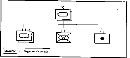
Figure 3-6. Two of the Kuwaiti armored brigades.
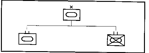
Figure 3-7. One of the Kuwaiti armored brigades.
Copyright: Reprinted from The Military Balance 1990-91, IISS (London).
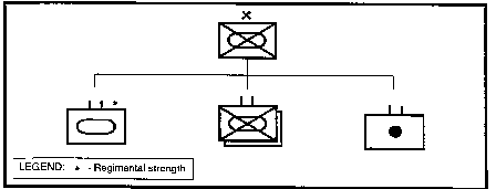
Figure 3-8. Kuwaiti mechanized infantry brigade.
a. The Kuwaiti Air Force has been reorganized and fundamentally rebuilt since 1991. The air force headquarters at Kuwait City is also responsible for air defense. These forces do not represent, in themselves, a significant threat to Kuwait's neighbors but will be used to support ground operations. The Kuwaiti Air Force is organized as shown in Table 40. Military airfields are at Ahmed al Jabar and Ali al Salam (Table 39 and Figure 3-4).
Table 40. Kuwaiti Air Force units.
|
b. The Kuwait Navy suffered badly during the Iraqi invasion and occupation. Iraq returned the majority of the vessels that survived the Gulf War in 1993 but they were in poor condition and were subsequently scrapped. It has not received the same level of support for the rebuilding process as the land and air forces. The main naval base at Ras Al Jalaya is to be rebuilt at an estimated cost of US $300 million. The Kuwaiti Navy has the following equipment (Table 41). 2 x commando battalions of Marines are attached to the Navy. Naval bases are at Mina al Ahmadi and Shuwaykh (Figure 3-4).
Table 41. Kuwaiti Navy equipment.
|
Copyright: Reprinted from The Military Balance 1990-91, IISS (London).
c. Paramilitary forces consist of a National Guard. Their primary duties are to guard the palace and the national border.
d. Kuwaiti Armed Forces manpower is shown in Table 42.
Table 42. Kuwaiti Armed Forces strength.
|
Copyright: Reprinted from The Military Balance 1990-1991, IISS (London).
Practice Exercise