

|
RDL Homepage |
Table of Contents |
Document Information |
LESSON 2
IRAQ
Critical Task: None
OVERVIEW
LESSON DESCRIPTION:
In this lesson, you will learn to describe the history, weather, terrain, and LOCs; and identify military capabilities of Iraq.
Terminal Learning Objective:
| TASK: | Describe the history, weather, terrain, and LOCs; and identify the military capabilities of Iraq. |
| CONDITION: | You will be given extracts from CIA World Factbook 1997, DA Pam 550-31, FM 34-72 (Coordinating Draft), FM 44-30, USAITAC Order of Battle Handbook AIA-DS-1-90, USAITAC Order of Battle Handbook AIA-DS-2-90, 11th SFG Field Order of Battle handbook, NTC Handbook 100-91, USAIC&FH SupR TCSUCC, and the IISS The Military Balance 1990-1991. |
| STANDARDS: | Description of the history, weather, terrain and LOCs; and identification of military capabilities of Iraq will be in accordance with CIA World Factbook 1997, DA Pam 550-31, FM 34-72 (Coordinating Draft), FM 44-30, USAITAC Order of Battle Handbook AIA-DS-1-90, USAITAC Order of Battle Handbook AIA-DS-2-90, 11th SFG Field Order of Battle Handbook, NTC Handbook 100-91, USAIC&FH SupR TCSUCC, and IISS The Military Balance 1990-1991. |
| REFERENCES: | The material contained in this lesson was derived from the following publications: CIA World Factbook 1997. DA Pam 550-31. FM 34-72 (Coordinating Draft). USAITAC Order of Battle Handbook AIA-DS-1-90. USAITAC Order of Battle Handbook AIA-DS-2-90. 11th SFG Order of Battle Handbook. NTC Handbook 190-91. USAIC&FH SupR TSCUCC. IISS The Military Balance 1990-1991. Microsoft Encarta 98 Encyclopedia. Milnet 1998 Website at http:www.milnet.com/milnet/index.html. Jane’s Sentinel Security Assessment. The Gulf States and update Apr 98. |
INTRODUCTION
This lesson is an attempt to treat in a concise and objective manner the military aspects of Iraq. Part A describes the history, weather, terrain, and LOCs which are still pertinent. However, Part B, military capabilities, are somewhat changed after Operation Desert Storm. These factors should be considered in studying the lesson. Military equipment of Kuwait is in Subcourses IS3010 and IS3011.
PART A. HISTORY, WEATHER, TERRAIN, AND LOCs OF IRAQ
1. General Information. Iraq (ee RAHK) is an Arab republic in southwestern Asia which is slightly larger than California. The country is bordered to the north by Turkey, to the west by Syria and Jordan, to the south by Saudi Arabia, Kuwait, and the Persian Gulf, and to the east by Iran. Figure 2-2 is a country outline of Iraq.
2. Statistical data of Iraq as of 1987 is as follows:
|

Figure 2-1. Flag of Iraq

Figure 2-2. Iraq.
3. History.
a. Historical background.
(1) Ancient Mesopotamia, the "land between the waters," was located between the Tigris and Euphrates Rivers of Iraq. It is part of the "Fertile Crescent" and has been called by anthropologists as the "Cradle of Civilization," possibly the site of the Garden of Eden. One of the first civilizations of the world, Sumer, evolved here more than 5,000 years ago. The first Sumerians are believed to have been immigrants from the highlands of Turkey and Iran. As the area developed, migrations and invasions became more common and influenced the cultural make-up of the region. By the mid-24th century B.C., the Sumerians were overrun by the Akkadians and thus began the rising and falling of a long series of empires in the area. With the spread of iron new weapons of war were developed and the Kingdom of Ashur--or Assyrian, as it is usually called-from the northern part of this region began dominating its neighbors. After the Assyrians fell in the seventh century B.C. the Babylonians reestablished their empire in the region and they were followed by the Medes, Persians, Greeks, and Romans.
(2) Following the seventh century A.D., Islam became entrenched in what is now Iraq. Baghdad, the capital of the Abbasid Caliphate (Islamic Empire), was the leading city of the world for five centuries and was the acknowledged leader of the Arab and Muslim world. In 1258 Baghdad was devastated by the Mongols and was later occupied by the Ottoman Turks. After World War I, the Turks were driven from the area by the British. Britain then created a mandate from three former Ottoman provinces and called this new country Al Iraq (the origin), the name formerly applied to only the southern region of the province of Basra. In 1932, Britain gave independence to this mandate and Iraq became a sovereign, independent state. However, Britain still maintained troops in Iraq and greatly influenced the government.
b. Recent history.
(1) In 1933, Iraq's King Feisal died. His death coincided with political unrest and dissatisfaction with the government. In 1936, Iraq experienced its first attempted coup d'etat and between 1936 and 1941 there were six more abortive coup attempts. All of these attempted coups were motivated by personal goals rather than political issues. In January 1943, pro-British Iraq declared war on the World War II Axis powers (Germany, Italy, and Japan) under the terms of a treaty with Britain. In 1945 Iraq became a founding member of the League of Arab States. Postwar Iraq, however, did not regain the stature it enjoyed in the pre-World War II Arab world. After joining the United Nations (UN) in December 1945, Iraq bitterly opposed the UN partition of Palestine and in 1948 entered the war against Israel.
(2) In 1958 King Faisal II of Iraq was executed in a coup by army officers. The leaders of the new regime declared their nation a republic committed to a foreign policy of nonalignment. Iraq's foreign policy, however, moved from a pro-West stance to one of friendly relations with the communist powers. Relations with the US were severed in 1967 after the US provided aid to Israel in the Six Day War.
(3) The Iraqi Baath (Resurgence) Party came to power through a coup in 1968 and Saddam Hussein became the number two man in the regime. By 1976 Hussein had in reality become the power in the regime and in 1979 he took complete control. The Baath regime closely parallels those that have existed since the overthrow of King Feisal II in 1958. The Government is controlled by Sunni Arab military elements who have succeeded in avoiding commitments to a political union with other Arab states. Hussein's Baath Party dominates both military and civilian communities.
(4) During the 1960s and 1970s Iraq had become increasingly more dependent on the former Soviet Union for military assistance. However, after the Soviets reneged on some military aid deals and provided inferior replacement equipment for war losses, the Iraqis began to improve relations with the West and decrease their dependence on the Soviets. During the late 1970s several border clashes with Iran increased tensions between the two countries. In 1979 Saddam Hussein expelled the Ayatollah Khomeini from Iraq, where he had been in exile since 1961. Removed from the seat of Shiite learning in Iraq, Khomeini vowed he would have Hussein's head brought to him on a platter. In February 1980 the Shah's caretaker's government fell and Khomeini returned to Iran via France vowing to spread the Islamic Revolution to the whole world. In September 1980, before Khomeini could consolidate his power, Iraq invaded Iran and the two countries were locked in war until September 1988, when a cease fire was agreed to, but no peace settlement has yet been achieved.
(5) In August 1990 Iraqi troops occupied Kuwait. The United Nations passed 12 resolutions and urged Iraq to leave Kuwait by 15 January 1991, but to no avail. United States and multi-national forces were rushed into Saudi-Arabia in response to an urgent call from the rulers of Saudi Arabia and Kuwait. On 16 January 1991 the Gulf War started with thousands of bombing raids in an effort to evict Saddam Hussein and his Iraqi forces from Kuwait. On 23 February 1991 the ground war started; it ended in a US and multi-national forces victory after 100 hours fighting by ground forces. Kuwait was liberated and fighting erupted between Iraqi troops and Shiite and Kurd rebels.
(6) Hundreds of thousands of Kurdish refugees fled to Turkey and Iran. U.S. British, and French troops landed inside Iraq's northern border to set up refugee camps to protect another 600,000 Kurds from Iraqi government reprisals. Throughout 1992 Iraq came under increasing international pressure to eliminate its remaining weapons of mass destruction.
(7) In 1993 UN officials announced that they had completed dismantling Iraq's nuclear, biological, and chemical warfare capability, prompting calls by Iraq to end the UN-sponsored trade embargo. Again in October 1994 the U.S., Britain and France responding to another buildup of Iraqi troops along the border with Kuwait deployed about 40,000 troops and more than 600 aircraft to the Persian Gulf region. Many analysts thought Iraq was trying to force the UN to lift its trade embargo against Iraq. A short while later, Iraq's soldiers were withdrawn from the border. In November Saddam Hussein signed a decree formally accepting Kuwait's sovereignty, political independence, and territorial integrity. The decree effectively ended Iraq's claim to Kuwait as a provincial territory.
(8) In 1994 Iraq continued its efforts to crush internal resistance with an economic embargo of the Kurdish-populated north and a military campaign against Shiite Muslim rebels in the south. The Shiites were quickly quieted, but the crisis in Kurdistan, which had long suffered from internal rivalries, continued. Kurds had often argued over land rights, and as their economic and political security deteriorated in the early 1990's, the conflicts escalated. In May 1994 supporters of the Patriotic Union of Kurdistan (PUK) clashed with supporters of the Kurdistan Democratic Party (KDP), leaving 300 people dead. Over the next two years the UK and KDP fought several more times, eventually devolving into a state of civil war. In August 1996, leaders of the KDP asked Iraqi president Saddam Hussein to intervene in the war. Hussein sent at least 30,000 troops into the UN-protected Kurdish region, capturing the PUK stronghold of Irbil. The KDP was immediately installed in power. The U.S. responded with two missile strikes against southern Iraq, but in early September Iraq again helped KDP fighters, this time taking the PUK stronghold of As Sulaymaniyah.
4. Weather.
a. Climate.
(1) The Iraqi climate is similar to that of the extreme southwestern United States with hot, dry summers, cold winters, and a pleasant spring and fall (Table 17). Roughly 90% of the annual rainfall occurs between November and April, most of it in the winter months from December through March. The remaining six months, particularly the hottest ones of June, July, and August, at approximately 102° F (32° C), are dry. The summer months are marked by two kinds of wind phenomena. The southern and southeasterly "Sharqi," a dry dusty wind with occasional gusts up to 80 km per hour, occurs intermittently from April to early June and again from late September though November. The wind is often accompanied by violent dust storms that may rise to several thousand meters in altitude, causing hazardous flying conditions. From the north and northwest comes the "Shamal," a steady prevailing wind from mid-June to mid-September. Very dry air which accompanies the shamal permits intensive sun heating of the land surface but also provides some cooling effect. The influence of the Persian Gulf on the climate of Iraq is very limited. Near the gulf the relative humidity is higher than in other parts of the country.
Table 17. Annual temperatures (° C).
|
(2) In the western and southern desert region, the climate is characterized by hot summers and cool winters. This region also receives brief violent rainstorms in the winter that usually total about 10 centimeters (cm). Most nights are clear in the summer, and about one third of the nights are cloudy in the winter.
(3) In the rolling upland (foothill) region there is basically no precipitation in the summer and some showers in the winter. The winter rainfall normally averages about 38 centimeters (cm). The nights are generally clear in the summer and in the winter dense clouds are common about half of the nights.
(4) The alluvial plain of the Tigris and Euphrates Delta in the southeast receives most of its precipitation accompanied by thunderstorms in the winter and early spring. The average annual rainfall for this area is only about 10 to 17 cm. Half of the days in winter are cloudy, and in the summer the weather is clear most of the time.
(5) In the mountains of the north and northeast the climate is characterized by warm summers and cold winters. Precipitation occurs mainly in winter and spring, with minimal rainfall in summer. Above 1,500 m, heavy snowfalls occur in the winter, and there is some thunderstorm activity in the summer. Annual precipitation for the whole region ranges from 40 to 100 cm. Few nights are cloudy in summer and about half of the days are cloudy in winter.
b. Light tables. Light tables reflect the average times, by month, for sunrise and sunset. At the times shown in Table 18, general outlines of the horizon may be visible but probably cannot be distinguished.
Table 18. Light table.
BAGHDAD, IRAQ
SUNRISE
SUNSET
|
5. Terrain. Iraq is divided into four main terrain zones or regions: the desert in the west and southwest; the rolling upland between the Tigris and Euphrates rivers (in Arabic, the Dijhis and Furat, respectively); the highlands in the northeast; and the central and southeastern alluvial plain through which the Tigris and Euphrates flow (the Tigris Euphrates Valley) (Figure 2-3).
a. Terrain features.
(1) The desert zone constitutes 38% of the total land area and lies west and southwest of the Euphrates (Nahr al Furat) River; it is a part of the Syrian Desert. The region is sparsely populated and consists of a wide stony plain interspersed with rare sandy stretches. A widely ramified pattern of wadis runs from the border to the Euphrates. Some wadis are more than 400 km long and carry brief, but torrential floods during the winter rains.
(2) The uplands region, between the Tigris north of Samarra and the Euphrates north of Hit, is known as Al Jazirah and is part of a larger area that extends westward into Syria, between the two rivers, and into Turkey. Water in the area flows in deeply cut valleys. Much of this zone may be classified as desert.
(3) The northeastern highlands begin just south of a line drawn from Mosul to Kirkuk, and they extend to the borders with Turkey and Iran. High grounds, separated by broad, undulating steppes, give way to mountains ranging from 1,000 to 4,000 m near the borders. Except for a few valleys, the mountain area proper is suitable only for grazing in the foothills and steppes; adequate soil and rainfall make cultivation possible. Iraq's largest oil fields are located near Mosul and Kirkuk.

Figure 2-3. Terrain features and natural regions of Iraq.
(4) The alluvial plain begins north of Baghdad and extends to the Persian Gulf. The Tigris and Euphrates rivers lie above the level of the plain in many areas in this region. The whole area is a delta interlaced by the channels of the two rivers and by irrigation canals. Intermittent lakes, fed by the rivers in flood, also characterize southeastern Iraq. A fairly large area just above the merging of the two rivers at Al Qurnah and extending east of the Tigris beyond the Iranian Border is marshland, known as the Hawr al Hammerar. Much of it is permanent marsh, but some parts dry out in early winter, and other parts become marshland only in years of great floods.
NOTE: General trafficability is depicted in Table 20.
b. Urban areas.
(1) Within the last 10 years, Iraq's urban and rural society has been expanding and undergoing rapid social change. The growth of the Baghdad and Basra urban centers, for example, has been astounding. The accelerated urbanization process throughout the country has resulted in a dramatic decrease of the population in the rural areas. The growth of the cities reflects the concentration of trade, construction, and real estate business activities fed by oil revenues and agricultural surpluses.
(2) Most rural inhabitants live in villages where houses and buildings are of primitive construction and are similar in size and shape. In the south the majority of the houses are made of mud and reeds, and in the north they are made of stone. The villages are generally located along rivers or canals and dwellings are built in irregularly patterned clusters connected by narrow, winding roads. The larger villages have a central area where the mosque and one or more coffee houses are located. Within these rural areas, state funds are being used to update or introduce electricity, potable water, and health services.
c. Coasts and beaches. Iraq has 58 km of coastline along the Persian Gulf and claims 12 nm as its territorial waters. Coast and beach access to Iraq is discussed in Table 19.
Table 19. Coast and beach access.
|
Table 20. Trafficability.
|
6. LOCs. LOCs in Iraq had improved considerably during the 1980s, but Operation Desert Storm reversed this trend. The most important transportation axis lies roughly north and south between Mosul, Kiruk, Basra, and the Persian Gulf via Baghdad. It parallels the Tigris and Euphrates river systems. Iraq had ambitious plans for the expansion of its transportation and communications network. The Iran-Iraq War created a shortage of funds for some of these projects and Desert Storm destroyed or severely damaged most of the bridges on the main Baghdad to Basra LOCs. Key rail lines and roads were also severely damaged and it will probably be a long time before normal LOCs will be reestablished, let alone be expanded.
a. Roads. Although many bridges were seriously damaged by allied bombing during the Gulf war, the damage causes then has been substantially repaired. Nearly all of the major cities are linked by paved roads. These paved roads are heavily used and require considerable maintenance. The secondary and feeder roads are primarily unpaved. Driving is affected by summer heat and limited by obstructions and rough surfaces off the main roads. A 1,200 km six-lane expressway was being constructed to link Iraq, Kuwait, Jordan, and Syria and will pass through Baghdad, Diwaniya, and Basra. A similar expressway was being planned to link Baghdad with the Turkish border via Kirkuk, Irbil, and Mosul. The road network is described in Tables 21 and 22. Figure 2-4 locates the main roadways.
Table 21. Road network.
|
Table 22. Roadways.
|
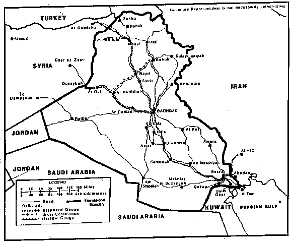
Figure 2-4. Roads and railroads of Iraq.
b. Railroads.
(1) The Iraqi Republic Railway system consists of two separate railroads. One is the standard 4.71 feet (ft) (1,435 m) gauge; the other is the 1-meter gauge. Total track of both gauges is 2,032 km. Table 23 identifies the Iraqi rail network. Table 24 and Figure 2-4 identify and locate the main routes.
(2) In the 1980s Iraq started to increase its rail network substantially with the addition of more standard gauge, high-speed tracks. A new line from Baghdad to Umm Qasr, via Basra, was under construction. A 273 m line was also under construction between Al Hadithad and Kirkuk, via Bayji. All lines entering Baghdad were scheduled to be connected to a new 112 km Baghdad loop line. Furthermore, Iraq planned to provide links with Kuwait and Saudi Arabia.
(3) The Iraqi railway network has suffered serious disruption as a result of both the Gulf War and the subsequent sanctions imposed. In 1992, freight loads had been cut in half from the previous year's total. However, passenger traffic has actually increased. Railway construction is attempting to reverse this downward trend. The main priority has been the development of lengthy branch lines serving industrial plants. Baghdad remains, however, the focus for the majority of railway lines, and a key component of the new main line plans is a Baghdad Belt Line of 112 km, from which the new trunk routes will extend in flying or burrowing junctions. This scheme, involving three major river bridges and a 7.5 km tunnel, is also motivated by anxiety to separate Baghdad area passenger and freight traffic to the maximum extent.
Table 23. Railroad network.
|
Table 24. Main railway routes.
|
c. Iraqi port facilities are located on the Persian Gulf. Due to the conflict between Iran and Iraq, operations at these ports have been stopped or been limited for some time. Before utilizing some of the port facilities again, the Shatt al Arab was cleared of bombs and wreckage and then dredged. Table 25 provides a listing of Iraqi ports and their capabilities: Figure 2-5 identifies their locations. Basrah and Umm Qasr are the primary commercial ports of Iraq, although a port was opened at AzZubayr (Khoral-Zubair) in 1979, only to be closed again in 1980, because of the Iran-Iraq war. Az Zubayr and Umm Qasr are operational again, with 25 berths claimed to be working by the Iraqi authorities. Az Zubayr, southwest of Basra is an industrial port complex for fertilizer exports, and imports of iron ore for the development of an iron and steel complex. The naval port of Umm Qasr has been handed over to Iraq by the UN border delimitation and there are problems over access to the channel leading to the port itself, which is also under Kuwaiti control. The oil port of Faw was destroyed during the Iran-Iraq war. Iraqi shipping lines provide cargo and tanker service between the Persian Gulf and European ports.
Table 25. Ports.
*Includes fuel, fresh water, and food. |
d. Air transportation. The government-owned Iraqi Airways, headquartered in Baghdad, flew domestically and internationally but Desert Storm destruction and the flight of Iraqi aircraft to Iran will preclude near term resumption of these services. Airfield types are depicted in Table 26 and airfield locations are identified in Table 27. There are two major international airports in Iraq, at Baghdad and Basrah: in addition, there are over 100 other airports of varying sizes scattered around the country. Major airfields are shown in Figure 2-5.
Table 26. Airfield types.
*Runway lengths are for paved and unpaved usable airfields only. |
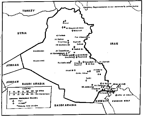
Figure 2-5. Ports and airfields of Iraq.
Table 27. Airfields
*Runway length 2,400 m or longer. |
e. Water transportation. There are 1,015 km of waterway in Iraq. The Shatt al Arab is navigable by maritime traffic for approximately 100 km, and the Tigris and Euphrates are navigable by shallow-draft vessels. Barge traffic can navigate the lower portion of the Tigris to Baghdad, but the middle and upper portions of the Tigris River are not navigable. The usable waterways of the Tigris and Euphrates are essential to the life of the country (Figure 2-6). These waterways are under control of the State Organization of Iraqi Ports and have 1,036 registered river craft and 153 motor vessels at their disposal. In December 1992, Iraq opened a Third River, a man-made drainage canal midway between the Tigris and the Euphrates. The Third River is 565 km long and is wide enough to take 5,000-ton barges with cargo traveling from southern Iraq to Baghdad. The waterway is officially described as a replacement for the blocked Shatt al-Arab. But it is alleged that there are other reasons for its construction, such as draining the marsh lands between the rivers in the south to displace the Shia Muslims who have taken refuge there, and to enable Iraq to exploit the oilfields of the southern region.
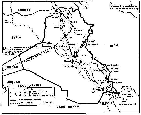
Figure 2-6. Water transportation and Pipelines of Iraq.
f. Pipelines. Iraq has a pipeline system consisting of in-country lines to the Persian Gulf and two international lines that pass through Turkey and Syria to Mediterranean terminals. The trans-Syrian pipeline was shut down by Syria during the Iran-Iraq war and the other pipelines were shut down at the beginning of the Gulf War in August 1990. Figure 2-6 and Table 28 locate and identify the pipelines. During the Iran-Iraq War, Iraq constructed a trans-Saudi pipeline, but that too was shut down in August 1990. Iraq's oil industry is very vulnerable to external forces, as shown by these past events.
Table 28. Pipeline network.
NOTE: A pipeline from Al Hadithah to Haifa, through Jordan, has been shut down since 1948 and is unusable. |
PART B: MILITARY CAPABILITIES OF IRAQ
1. Background.
a. The Iraqi Armed Forces were formed by the British after World War I. In 1934 conscription was introduced and by 1941 the armed forces totaled well over 41,000 personnel. A reduction occurred after World War II, and by 1948 the military was further reduced to about 20,000, including an armed gendarmerie.
b. A series of attempted and successful coups d'etat from 1939 to 1968 resulted in a number of armed forces reorganizations and the transfer of control of the armed forces to various factions of government. Control of the armed forces was solidified under the President of Iraq after the Ba’ath party takeover in 1968.
c. The Iraqi armed forces were originally organized along the lines of the British general staff model. This organization governs land operations ranging from the lowest unit, the squad, up to the largest standing unit, the corps.
d. Soviet influence, combined with experience derived from the 1980-1988 Iran-Iraq war, have caused modification of the original British model in both organization and doctrine. Expediency and the wide range of equipment, organization, and training levels among units necessitate variations among units.
e. After the conclusion of Operation Desert Storm, the number of Iraqi tanks appears to have been cut in half. This is a result of both the decisive air war and the mass destruction in the less than two weeks of ground warfare. It appears that the Soviet technique used by the Iraqis of digging their tanks in only leaving the turret exposed, was a primary cause of the loss of so many tanks. U.S. volatile fuel-air weapons tended to work quite well at blowing the tops off the tanks. And when the U.S. tanks streamed around the front lines from the West, the buried tanks were unable to dig out and move quickly, thus defeating their purpose as a highly mobile high caliber gun.
f. With all the Iraqi chemical and biological facilities in ruin, Iraq's weapons of mass destruction were limited to those on hand in protected regions of Iraq, and any remaining SCUD missiles in the Iraqi inventory.
g. Also, during the war, to avoid the risk of being destroyed on the ground, many Iraqi aircraft were flown out of the country to Iran. After the war, the U.S. would not allow the return of these aircraft.
h. In October 1994, Iraq began moving forces toward Kuwait again, just as the U.S. began a gradual drawdown of forces in the region. By November 1994, the U.S. had redeployed a substantial number of troops in theater, and Iraq backed down.
i. All during the period following the Gulf War, the U.S. and coalition allies ran (and are still running) Operation Southern Watch enforcing a no fly zone in both Northern and Southern Iraq.
j. The U.S. Navy and coalition naval forces have also been conducting Maritime Intercept Operations in order to enforce the U.N. embargo on trade with Iraq until such time as they comply completely with U.N. Security council resolutions addressing weapons of mass destruction and other issues stemming from the Gulf War.
2. Command structure. The defense structure is headed by the President (Saddam Hussein), who is also the Minister of Defense and the Commander in Chief. Each of the three services is represented on the Revolutionary Command Council. The National Defense Council advises the President on military policy issues (Figure 2-7).
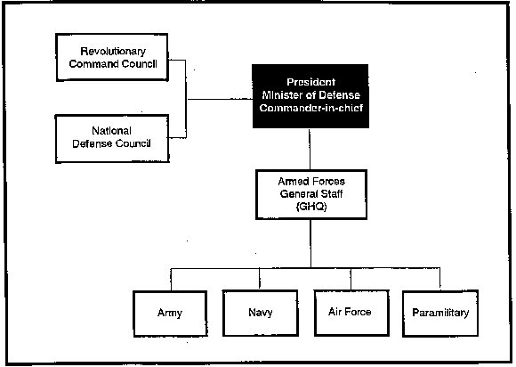
Figure 2-7. Iraqi Armed Forces command structure.
3. Iraqi Armed Forces. The branches of the armed forces include the Army, Air Force, Navy, and paramilitary forces. The President is Commander in Chief of the Armed Forces and exercises direct control in the defense of Iraq. The Armed Forces have two roles: to defend the regime and the country. The first goal is achieved through the Baghdad garrison and the general reserve. The second is achieved through the effective deployment of troops along hostile borders.
4. The Iraqi Army, formerly the world's third largest, had a troop strength of approximately 1,100,000 at the start of Operation Desert Shield. Prior to Operation Desert Storm it was considered one of the best equipped and most combat-experienced in the world. It could conduct multi-corps operations spread over 100 km or more and was capable of coordinating air and artillery, timing of movements and operations, coordinating complicated logistics requirements, and getting supplies, equipment, and troops to the right place at the designated time. Furthermore, the Iraqi Army was known by its flexibility, unity of command, and high level of mobility. The Army was highly qualified in planning, command and control (C2), logistics and maintenance, but limitations placed upon the commanders' initiative, especially in exploiting success, reduced these advantages. However, the Iraqi Army did not live up to these standards during the recent Gulf War. US and multi-national forces at first destroyed the Iraqi C2 centers, lines of communication (LOCs), and effectively bombed troop units and equipment in Iraq and Kuwait. Thereafter, it took US and multi-national forces only 100 hours of ground war before the Iraqis surrendered. Because of the massive destruction following the Gulf War, the amount of reliable information about the Iraqi military structure/organization and equipment is limited. Tactical doctrine and operational art have been refined and amended as a result of the defeat by coalition forces during the Gulf War. The following information is what is known. The estimated strength of the Iraqi Army is 350,000 active service soldiers, with the lower ranks undertaking compulsory military service. Conscripts serve for a period of between 18 and 24 months. Between 1990 and 1993, at least 100,000 reservists were called up for the invasion of Kuwait and for the operations against the Marsh Arabs. Since the Gulf War there has been a major re-structuring of the Iraqi armed forces. There has been a considerable downsizing in strength and in the numbers of divisions. As of early 1998, information for defectors and opposition sources indicated that the army now consists of five corps and 17 divisions, while the elite Republican Guard consisted of two corps and six divisions, the latter being composed of two mechanized divisions, two armored divisions and two infantry divisions. Iraq has three special forces brigades and one marine brigade. In addition to the Republican Guard, there is a super-elite formation, the Special Republican Guard (SRG) which takes a prominent role in the defense of the Baghdad area. The SRG has 13 battalions organized into a number of brigades and is about 26,000 strong. It is charged with defending the life of the president and preserving the Baath Party. Saddam's son Qusay is the supervisor of the SRG; the commander is General Kamal Mustafa al Tikriti, whose sister-in-law is Saddam's youngest daughter, Hala. SRG personnel are recruited mainly from Saddam's home area of Tikrit. There are units within the SRG dedicated to special operations and commando-style raids. The SRG has been active against the Marsh Arabs and the Kurds. A major reorganization of the armed forces was undertaken in December 1993. Saddam, as supreme commander-in-chief, reinstated the Popular Army concept, abolished after the Gulf War. During the crisis of early 1998, as Western forces gathered for a confrontation with Saddam over the UNSCOM weapons inspection issue, the regime embarked on a campaign to recruit a million Iraqis for the Popular Army. However, observers saw this more as a morale boosting exercise, rather than an effective military measure. There were reports in 1997 that Saddam's son Qusay was considering a new structure for the Iraqi armed forces, that would bring the army, the Republican Guard, the Special Republican Guard and other units under a unified command structure, with the collective title of the Iraqi Army. This prospective plan was seen as yet another move the regime to tighten control over the armed forces. Precise details are unavailable, but it is believed that units in the armed forces, especially the regular army, are well below full strength. The Republican Guard is also thought to be under-manned, but to a lesser extent than the regular army. In the Republican Guard, when numbers are up to full strength, a mechanized division consists of two mechanized brigades and an armored brigade, while an armored division consists of two armored brigades and a mechanized brigade. The Iraqi Army chain of command is shown in Figure 2-8.
NOTE: 2 x surface-to-surface (SSM) brigades with at least 50 x free rocket over ground (FROG) and 36 x Scud B/Abbas/Husayn launchers were used by the Iraqis during Operation Desert Storm. These brigades most likely operated independently and were under operational control of GHQ or the President.
a. Iraqi General Headquarters. The General Headquarters (GHQ) is the highest military echelon. Controlled by the Army, it integrates army, air force, navy, and popular army operations. While the GHQ is primarily a staff element, it can deploy a forward command post to the front. GHQ controls both regular army corps and a corps-level strategic reserve designated the Republican Guard Forces Command (RGFC) (Figure 2-9).
b. Iraqi regular army corps. The corps is the operational headquarters for the Iraqi Army. There is no intermediate headquarters between corps and GHQ. Regular army corps have territorial areas of operation. The RGFC, a mobile command conducting operations wherever directed, will be dealt with separately below. Iraqi corps bear the responsibility for administration and logistics as well as combat operations. The corps normally controls 3 to 4 x divisions. The burden of support operations and the command and control of additional elements often force corps to send out a forward command post.
c. Iraqi regular army corps organization. A regular army corps may control, at one time, from 3 to 4 x divisions with a mix of types of divisions. For example, 2 x infantry divisions (IDs) and 1 x armored divisions (AD) or 1 x ID, 1 x mechanized division (MD), and 1 x AD, etc. Other units organic to the corps can vary in number as shown in Figure 2-11.
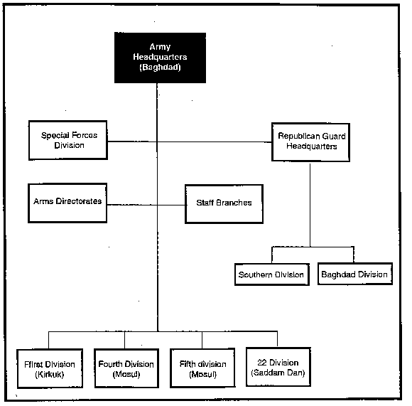
Figure 2-8. Army chain of command.
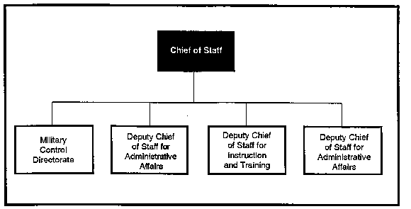
Figure 2-9. Iraqi GHQ organization.
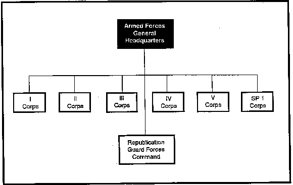
Figure 2-10. Iraqi GHQ and corps command relationships.
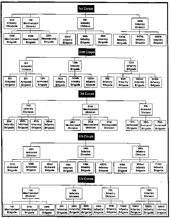
Figure 2-11. Iraqi army corps organization.
d. Iraqi regular army division.
(1) The Iraqi regular army has three basic types of divisions: armored, mechanized (mech) infantry, and infantry. The basic organizational structure of each type of division is similar. They consist of 3 x maneuver brigades, divisional artillery, and various combat support and service support units (Figure 2-12). Typically a mechanized infantry division has 3 x mechanized infantry brigades and an armored division has 3 armored brigades. The infantry division has 3 x infantry brigades.
e. Iraqi Republican Guard Forces Command (RGFC).
(1) Historicalevolution.
(a) Prior to the Iran-Iraq War, the Republican Guard was a 2 x brigade presidential guard force, whose mission was to secure the regime. Between 1982 and 1986, the Republican Guard was expanded to 6 x brigades and was given the additional mission of providing a small strategic reserve for counterattacks against Iranian penetrations of Iraqi defensive positions. They suffered heavy casualties in unsuccessful counterattacks following the February 1986 Iranian capture of Al Faw peninsula.
(b) That defeat and the lack of additional counterattacking forces convinced the Iraqi leadership that a large strategic reserve was needed. To create that reserve a major expansion of the Republican Guard was undertaken. The new Republican Guard Forces Command (RGFC) became a corps level organization with 2 corps and several division headquarters subordinate to it. By April 1998, the RGFC had grown to 7 x divisions of 22 brigades (Figures 2-12) and can be identified by a red triangle patch worn on the shoulder.
(2) Operational experience. The final two years of the Iran-Iraq war saw the development of a mature, experienced RGFC organization. The RGFC was employed skillfully as a strategic reserve in a series of two-corps defensive and offensive operations. The RGFC assumed a tactically offensive role: the counterattack.
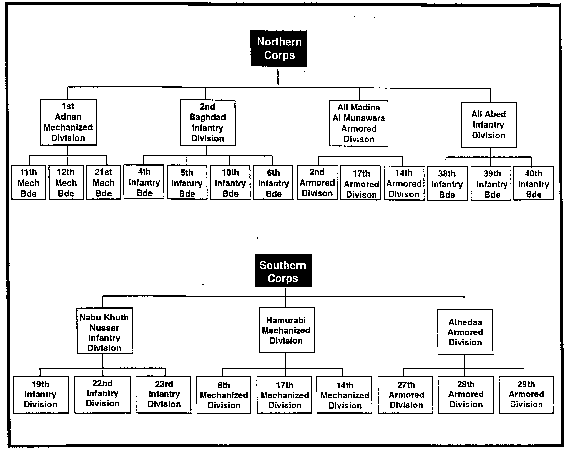
Figure 2-12. Republican Guard.
(3) Personnel.
(a) Unlike the conscript regular army, the Republican Guard is all volunteer and displays a motivation and initiative not found in conscripts. At its inception, only men from Saddam Hussein's home town were eligible for the Republican Guard. This limited the size of the Republican Guard to 3 x brigades.
(b) To expand the Republican Guard into a decisive force on the battlefield, eligibility was opened to volunteer college students from all parts of the country. With college deferments removed, large numbers of relatively well educated and motivated volunteers poured in to gain the prestige and benefits of being in the Republican Guard. This influx of fresh manpower, undaunted by the years of defensive warfare, enabled the Republican Guard to become the highly motivated and trained offensive force that it is today.
(4) Strengths. The RFGC is the best equipped and best trained force in the Iraqi ground forces. It is a self sufficient and self contained force with organic combat, combat support, and combat service support elements. It maintains its own supply system and has priority for all supplies. This results in "pampered" forces that are relatively well paid and receive the best food, uniforms, equipment, etc.
f. Iraqi Popular Army.
(1) The Iraqi Popular Army consists of a popular militia composed of civilian volunteers, members of the Ba'ath regime against internal opposition and to serve as a power base (and counter-balance) to the regular army.
(2) The Popular Army is organized on an area basis with a total of l9 divisions.
(a) Popular Army GHQ in Baghdad controls area HQs located in Baghdad and each of Iraq's 18 x administration districts. Each area HQ is commanded by a district commander.
(b) Each district controls a number of "sectors" headed by sector commanders.
(c) Each sector controls up to 10 "bases," led by platoon commanders. There are four types of bases:
1 Infantry or combat bases with infantrymen.
2 Command bases with commanders.
3 Close support bases with light mortars and MGs.
4 Antiaircraft bases, with antiaircraft (AA) guns and MGs.
(3) Each base contains up to 10 x squads of from 10 to 15 men. Personnel are assigned to squads based on their residences, to ensure swift mobilization.
(4) Training in the Popular Army is limited to several weeks prior to mobilization, although some instructors come from the regular army to help improve the quality of training. Training is conducted in:
(a) Physical training.
(b) Use of arms (mainly small arms).
(c) Obstacle crossing (including wire and mine obstacles).
(d) Assaults on enemy positions.
(e) Searches in mountainous terrain.
(f) Possible air assault training for Popular Army commandos.
5. Iraqi Air Force. The mission of the Air Force is to conduct independent air attacks against enemy targets, to participate in the defense of the country against hostile air action, and to support the Army and Navy by air strikes, reconnaissance, and air supply and transport. Air bases are located at Al Sahra, Al Taqaddum, Amara New, Baghdad/Muthenna, Balad Southeast, Irbil, Injanah, Jalibah, Karbale Northeast, Kirkuk, Mosul, Najaf, Qayyarah, Rasheed, Safwan, Salman Pak, Salum, Samarra East, Shaibah, Shayka Mazhar, Sabakhu, Tallil, and Ubaydah Bin al Jarrah. Figures 2-13 and 2-14 show the force trends from 1975-1998 broken down by manpower and weapon type.
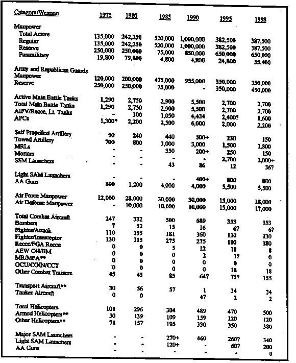
Figure 2-13. Force Trends in Iraq (Part one).
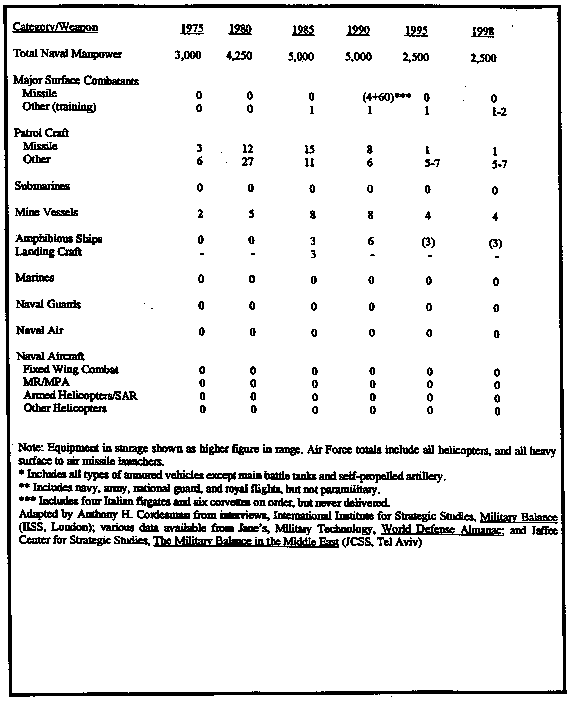
Figure 2-13. Force Trends in Iraq (Part Two) (continued).

Figure 2-14. The impact of Coalition Air and Land Forces on Iraq.
Equipment Strength in the Kuwaiti Theater of Cease-Fire.
2-14 shows the impact of coalition forces on equipment left behind in the Kuwait: theater of operations (KTO) at the time of the ceasefire.
Table 29 shows the Iraqi armed forces at the start of operation Desert Storm.
Table 29. Iraqi Armed Forces strength.
|
6. Foreign Forces. There were 400 foreign troops of UNIIMOG in Iraq/Iran from Austria (medical), Ireland (military police), New Zealand (Air Force), and observers from 25 countries prior to Operation Desert Storm. They were to monitor the Iran/Iraq border area. In August 1991 a UN observation team with personnel and equipment from US, UK, and Germany moved into Iraq to monitor the destruction of Iraqi nuclear research plans and equipment.
Practice Exercise