

|
RDL Homepage |
Table of Contents |
Document Information |
LESSON 1
IRAN
Critical Task: None
OVERVIEW
LESSON DESCRIPTION:
In this lesson, you will learn to describe the history, weather, terrain, and LOCs; and identify the military capabilities of Iran.
Terminal Learning Objective:
| Action: | Describe the history, weather, terrain, and LOCs; and identify the military capabilities of Iran. |
| Condition: | You will be given extracts from CIA World Factbook 1997, DA Pam 550-68, FM 34-72 (Coordinating Draft), and IISS The Military Balance 1990-1991. |
| Standards: | Description of the history, weather, terrain and LOCs; and identification of the military capabilities of Iran will be in accordance with CIA World Factbook 1997, DA Pam 550-68, FM 34-72 (Coordinating Draft),and IISS The Military Balance 1990-1991. |
| REFERENCES: | The material contained in this lesson was derived from the following publications: CIA World Factbook 1997. DA Pam 550-68. FM 34-72 (Coordinating Draft). IISS The Military Balance 1990-1991. Microsoft Encarta 98 Encyclopedia. Milnet 1998 Website at http:www.milnet.com/milnet/index.html. Jane's Sentinel Security Assessment. The Gulf States and update Apr 98. |
INTRODUCTION
This lesson is an attempt to treat in a concise and objective manner the dominant military aspects of Iran. Information used in this lesson was obtained form unclassified sources. Military equipment of Iran is in Subcourses IS3010 and IS3011.
PART A: HISTORY, WEATHER, TERRAIN AND LOCs of IRAN
1. General information. Iran (ee RAHN) is an ancient country of the Middle East located in Southwestern Asia which is about two and a half times larger than the state of Texas. The country is bordered to the north by the former (independent) Soviet Central Asian Republics of Turkmeinistan, Azerbaijan and Armenia, to the west by Turkey and Iraq, to the south by the Persian Gulf, and to the east by Afghanistan and Pakistan. Figure 1-2 shows a country outline of Iran.
2. Statistical data.
| Name: | The Islamic Republic of Iran (Jumhurive Islamiye Iran) |
| Capital: | Tehran |
| Population: | 67,540,002 (July 1997) |
| Area: | 1,648,000 square kilometers (km2) |
| Ethnic divisions: | 51% ethnic Persian, 24% Azerbaijani,7% Kurd, 8% Gilacki and Mazandarani, 2% Lur,1% Baloch, 1% Arab, and 3% other. |
| Literacy rate: | 72.1% |
| Religion: | 89% Shiite Muslim, 10% sunni Muslim,1% others. |
| Language: | Farshi, Kurdish, Turkic, Arabic, Aramic, Armenian, English, French, and German. |
| Gross national product (GNP): | $ 80 billion |
| Per capita income: | $1,400/annum |
| Unit of currency: | Iranian rial (IR) |
| Exchange rate: | $1 - $1,755.12 IR (Jan 1997) |
| Time zones: | Three hours ahead of universal time coordinated (UTC); eight and a half hours ahead of US Eastern Standard Time; time zones are CHARLIE and DELTA. |
| Defense forces: | Army, Revolutionary Guard Corps (RGC), Air Force, Navy, and paramilitary forces. |
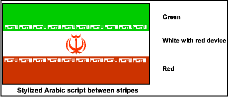
Figure 1-1. Flag of Iran.
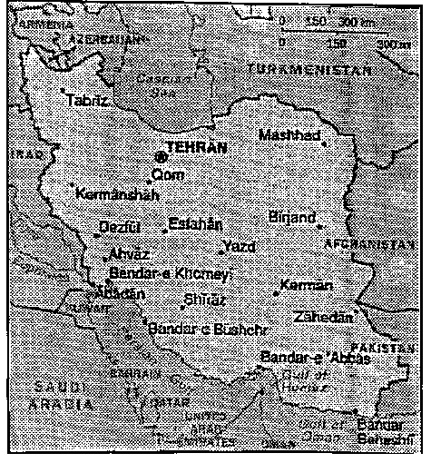
Figure 1-2. Iran.
3. History.
a. Historical background.
(1) Present-day Iran--formerly known as Persia--has been occupied by peoples with a variety of cultures since 6000 B.C. The harsh geography of the region, which is made up of high mountains, forbidding deserts, and huge, uninhabitable salt marshes, discouraged the early formation of a centralized political or economic entity and postponed the growth of urban centers. Persia's recorded history began in approximately 1000 B.C. when small groups of nomaic, horse-riding peoples (Persians, Medes, and Scythians) speaking Indo-European languages began moving into the area from Central Asia. During the sixth century B.C., Cyrus 11 (Cyrus the Great) combined the forces of the Persians with the Medes and set out to establish the most extensive empire in the ancient world.
(2) After the fall of the Persian Empire, Persia was invaded numerous times. Its diverse ethnic blend is the result of waves of foreign invaders who enriched the cultural development of the Persians. This adoption also occurred with Islam. By clinging to their own traditions and values, the Persians established Islam as a universal religion apart from Arab dominance.
(3) During the seventh century A.D. the first and greatest religious split in Islamic history occurred and had a lasting impact on Persia's civic and religious culture. By the 10th century, almost 90% of Persians were Shiites, the largest Shiite population of any country in the Middle East.
(4) By the early 1900s, popular unrest grew with the presence of many foreigners--British, Russians, American, and Germans--who administered and exploited the country. In February 1921 a bloodless coup d'etat occurred in Tehran, and in December 1925 the new Pahlavi Dynasty and administration was installed. In 1933, Shah Reza Khan Pahlavi declared himself Emperor of the Islamic Republic of Iran (farsi name of country) and two years later it was formally recognized as Iran.
b. Recent history.
(1) In 1978 domestic turmoil swept the country as a result of religious and political opposition to the shah's rule. Opponents were particularly critical of western influences on programs which did not conform to the fundamentalist interpretation of Shia Islam. In January 1979 the shah, after appointing a fourth Prime Minister in less than a year, bowed to strong opposition and departed the country. The opposition within Iran originally came from two main sources--the left and the liberal National Front--but was eventually overshadowed by the opposition led by the exiled religious leader, the Ayatalloh Khomeini. As support grew for Ayatollah Khomeini toward the end of 1978 and the beginning of 1979, he realized an opportunity to form his own government. While still in exile in Iraq, he established the Islamic Revolutionary Council in anticipation of his return to Iran. In February 1979 the Ayatollah Khomeini returned to Iran and ten days later his armed followers overthrew the government left by the Shah. The Ayatollah then appointed a Prime Minister to form a new government and at the end of March, voters overwhelmingly approved formation of the Islamic Republic of Iran.
(2) On 1 April 1979 an Islamic republic was formed; the government, under Ayatollah Khomeini's autocratic rule, has since been characterized by indiscriminate arrest, torture, execution of opponents, and economic disorder. Political development has been marred by factional fighting, confusion, and continual crises. These crises include the seizure (and eventual release) of 52 members of the US Embassy staff, an undeclared war with Iraq, internal power struggles and unrest between the major minority groups, and support of Shia terrorist groups in the Middle East.
(3) In September 1980 Iraq initiated military action against Iran. This conflict, in varying intensity, continued through August 1988 when a cease fire was agreed to.
(4) When Komeini died in June 1989, President Khamenei became Iran's supreme leader. In July Ali Akbar Hashemi Rafsanfani, former speaker of parliament, was elected president and significant amendments were made to the constitution to resolve conflicts between the Majilis and the Council of Guardians. Iran condemned both Iraq's invasion of Kuwait in August and the subsequent deployment of U.S. troops in Saudi Arabia, but resumed diplomatic relations with Iraq, which dropped its territorial claims against Iran. In the Persian Gulf War (1991), Iran remained officially neutral, but provided refuge for more than 100 Iraqi warplanes, which it later seized. After hositilities between allied and Iraqi forces ended, Iran helped Shiite rebels in southern Iraq against the Baghdad government. Rafsanjani supporters won a parliamentary majority in 1992.
(5) Iran's relations with the West began to improve under Rafsanjani's leadership. The betterment in relations was due in part to Rafsanjani's role in obtaining the release of Western hostages held by pro-Iranian Shiite groups in Lebanon, the last of whom was released in 1992. The Iranian economy fared poorly under Rafsanjani as the national debt grew and inflation rose sharply. Iran continued to deny that is an international sponsor of terrorism and turned aside accusations by both Algeria and Egypt that Iran sponsored terrorist groups in their countries. In June 1993 Rafsanjani was reelected president.
(6) In May 1995 the U.S. cut off all trade and investment with Iran, including the purchase of crude oil by American companies for resale on the world market. The U.S. believed Iran was planning to develop weapons of mass destruction and was supporting international terrorism. Iran found other buyers for its oil among Western countries that did not join the boycott. In January 1996 Iran and Russia concluded a controversial agreement to complete a nuclear power plant at Bushehr which had been begun by West Germany 12 years earlier. Construction started soon after. International critics feared the plant would give Iran the ability to build nuclear weapons. In May 1997 Mohammed Khatami was elected president of Iran by a wide margin. (President Rafsanjani was prohibited by the constitution from seeking a third term.) Khatami, who campaigned for tolerance and social reform, had been minister of culture from 1982 until 1992, when his conservative critics forces him to resign.
4. Weather.
a. Climate.
(1) The climate of Iran is one of great extremes (Table 1). Seasonal changes are abrupt and clear cut; fall and spring are short. The prevailing winds and mountains combine to produce adequate precipitation in the northwest and along the Caspian Sea, but this moisture is minimal in the eastern deserts. The mountain country of the northwest, particularly the provinces of East and West Azerbaijan, receives sufficient precipitation and mountain runoff to support a variety of crops in the valleys. The four geographical regions of Iran are similar to the climatic subdivisions (Figure 1-3).
Table 1. Annual Temperatures in degrees centigrade (° C).
|
(2) The central plateau has little or no precipitation. Slight amounts of rainfall occur in winter and spring but generally not in summer. Thunderstorms may occur in the spring in the northwest corner by Tehran. Nights are generally clear in the summer, with dense clouds about half the time during winter nights.
(3) In the northern portions of the Zagros Mountains, the climate is somewhat different from the central and southern portion of the range. The northern part experiences heavy snow in winter at elevations of 1,500 meters (m) with some thunderstorms in spring. In the south precipitation is generally insignificant in summer and more pronounced in winter and spring. Skies are clear during most days and nights, with less than one-half cloud cover during winter and spring nights. The annual temperatures are warmer in the southern portion of the Zagros.
(4) The Elburz Mountains in the northern regions of the country have similar temperatures and precipitation to those of the northern Zagros. Snow never quite disappears from the northern slopes of the Elburz Mountains. About 650 km to the southeast, however, at elevations of 610 m are some of the hottest and driest areas of the world. Temperatures there compare to the southern Zagros Mountains. Along the Persian Gulf and Caspian coast, oppressively high humidity accompanies temperatures as high as 40° C.
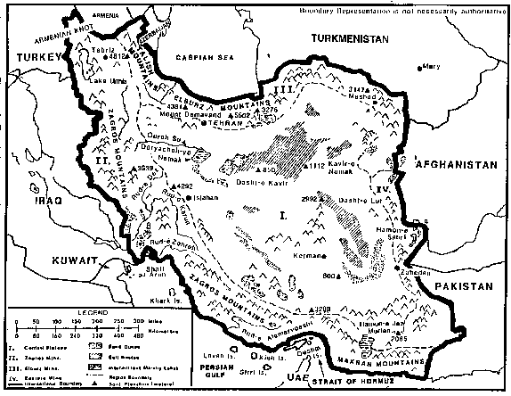
Figure 1-3. Terrain features and geographical regions of Iran.
(5) The eastern mountains experience no precipitation in summer with only a slight amount in winter and spring. Summer days are generally cloudless, whereas winter days are cloudy half the time. Some snow and occasional blizzards are possible in winter months.
(6) Two strong summer winds, the "shamal" in the northwest and "wind of 120 days" in the southeast intensify the already hot temperatures. The "wind of 120 days" blows regularly throughout the summer and is the most destructive of the two, reaching 160 km per hour at times.
b. Light tables. Light tables reflect the average times, by month, for sunrise and sunset. At the times shown in Table 2, general outlines may be visible; but the horizon ordinarily cannot be distinguished.
Table 2. Light table.
|
5. Terrain. The country is generally situated on a high triangular plateau. This plateau is part of a larger one that includes parts of Afghanistan and Pakistan. According to geologists, the region was formed and continues to be influenced by the uplifting and folding effect of three giant blocks or plates--the Arabian, the Eurasian, and the Indian--pressing against each other. Subterranean shifts produce numerous faults in the earth's crust, and it is along or near these faults that the country's frequent and devastating earthquakes occur.
a. Terrain features.
(1) The central plateau is a barren, largely uninhabited area which occupies a series of closed basins with elevations of 600 to 1,500 m; mostly surrounded by mountains. The interior of the plateau is partly covered by deserts called "dasht," which are among the driest and most barren in the world. Black, muddy, salt marshes called "kavirs," which are separated by barren hills and mountains, are also found in the interior of the plateau. In summer the kavirs become dry causing the salt to crystallize, crack, and upturn into jagged edges, making the area very dangerous for travel. In the winter months when the kavirs are wet, they become quagmires and will halt vehicles, animals, or personnel traffic. The desert is an extensive, arid basin with large expanses of sand dunes crossed by intermittent streams draining into the kavirs. Dasht-e Kavir and the Dasht-e Lut are the most prominent terrain features in the area and are devoid of inhabitants and vegetation. This region is commonly called "the dead heart of Iran." Ironically, the foothills of the surrounding mountains allow habitation, and much of the cultivation of the country is found here. Winter rains flowing from the foothills provide well water for the towns and villages. The high salt content these streams, however, causes the water supply to be of poor quality. The Hamun-e Jaz Murian, a large fresh water lake in the Southwest, exists only during the winter.
(2) The high, rugged Zagros Mountains extend from the Armenian Knot in the extreme northwest and follow the western border town to and along the Persian Gulf, where they join the Makran Range near Pakistan, in the northwest, the elevation varies form 2,100 to 4,100 m with steep and partly forested slopes containing intermittent lowland basins. Lake Urmia is located in one of these basins. Its saline composition is the result of the presence of highly salty soil and the absence of an outlet. Further south, mountains form parallel, dome-like ridges which are oriented northeast to southwest and vary in elevation from 2,500 to 4,000 m. These ridges are separated by deep, narrow, parallel valleys containing mostly perennial streams. The slopes are covered by open shrub forests, and the entire area is sparsely populated. Where the Zagros Mountains join the Makran range in the southern part of Iran, the combined ranges generally run east to west with elevations up to 1,000 m. Most valleys traverse mountains and drain into the Gulf of Oman where a narrow coastal plain stretches along the entire area. Water is generally plentiful all year in the northern portions of the mountains. Numerous streams in this area have fresh water much of the year but may become dry in summer. Wells and water storage cisterns are in or near populated areas. In the southern part of this area, most streams are intermittent, with fresh water becoming salty in the upper parts of the streams and becoming contaminated downstream. Fresh water is scarce along the coast.
(3) The Elburz and Talish Mountains located in the north extend into Afghanistan and have elevations from 2,100 to 3,000 m; in the northeast elevations exceed 4,400 m. Most valleys are narrow and steep-sided. Mount Damavand, an inactive volcano northeast of Tehran, is Iran's highest peak at 5,602 m. The streams draining towards the Caspian Sea flow most of the year, whereas streams draining towards the interior along the southern slopes are generally intermittent. The Caspian lowlands are flat to gently rolling, with dissected plains to the north of the Elburz Mountains. Streams, which are broad and slow-flowing, primarily empty into salt marshes along the coast. Numerous ditches and wide, shallow canals draw water from the streams for irrigation. Most of the area is densely populated; and portions of it are heavily cultivated, with natural vegetation consisting of grass, shrubs, and marsh weeds. The water of the Caspian Sea is drinkable in most places but is usually bitter, and well water on the east coast of the Caspian is brackish.
(4) The eastern mountains consist of hills and high rugged mountains with deeply cut valleys. Elevations can range from 1,200 to 2,750 m. The crest line is generally more than 460 m above adjacent basins and valley floors. Major streams through the valleys flow much of the year. Vegetation consists mostly of thorny shrubs 1 to 2 m high.
NOTE: See Table 3 for a general evaluation of trafficability.
b. Urban areas.
(1) The urban sector has grown at a rate three times that of the rural sector. Fifty percent of the population live in urban localities (areas with a population exceeding 5,000). Tehran, the capital, is located at the foot of the Elburz Mountains, a site identified in ancient times as the intersection between the silk route to China and the north-to-south route between the Caspian Sea and the Persian Gulf. Tehran is the industrial center of the country with specific immigration limits on its growth.
(2) Since the mid-1970s the government has been actively seeking an improved distribution of population and decentralization of economic activity. Large industrial centers are being established in Isfahan and Meshed with smaller ones near the cities of Kerman and Zahedan. Since the Khomeini takeover of the government, construction and industrial activities have not been restored to their prerevolutionary levels. This production lag has retarded the growth of the industrial centers, and their development status is presently unknown.
(3) Most of rural Iran is made up of farm villages, localities with populations of 50 or more people. Smaller populated areas are known as hamlets. Compared to the urban dwellers, the standards of living of those in the rural areas are lower, resulting in the desire of many to migrate to the urban areas. Little is known of the effect the new government has had on living conditions in the rural areas.
Table 3. Trafficability.
|
c. Coasts and beaches. The length of the Iranian coastline is 3,180 km and includes 676 km of island coastline. Iran claims 12 nautical miles (nm) as the limits of its territorial waters with fishing limits extending to 50 nm. The territorial limit overlaps that of Oman in the Strait of Hormuz. The Caspian Sea, the worlds largest land-locked body of water, has 630 km of coastline within Iran's borders. Due to the decline of the water level, now 28 m below sea level, the coastal plain is the former sea floor. Coast and beach access are further discussed in Table 4.
Table 4. Coast and beach access.
|
6. LOCs. During the 1970s there was extensive growth in the transportation and communications sectors. Since the revolution there has been little investment in expansion and maintenance of the transportation and communications systems. Low-maintenance levels on roads and railways have led to a reduction of efficiency in some of the existing routes. Only a limited number of improvement projects are in operation.
a. Roads. During the 1970s the extensive catch-up effort in the road system proved to be difficult and costly due to the size of the country and the rugged terrain. Emphasis was placed on linking the major population centers and economic areas. While areas without roads or modern transportation exist in Iran, its primary population areas are connected but lack sufficient feeder roads. In addition to the 33,000 km of surfaces roads (many of which are of unreliable quality), there are more than 50,000 km of roads with surfaces ranging from reasonable to extremely poor quality. There are two major highways. The A1, runs for 2,089 km from Bazargan on the Turkish border, through Tehran, to the Afghanistan border, and the A2 that runs for 2,473 km from the Iraqi border to Mir Javeh on the Pakistan border. Other roads link the main population centers. Table 5 identifies the road types. Main roadways and lengths are identified in Table 6 and depicted in Figure 1-4. The road from Tehran to the Persian Gulf is the most extensively used corridor, accounting for approximately half of all road traffic.
Table 5. Road network.
|
Table 6. Roadways.
|
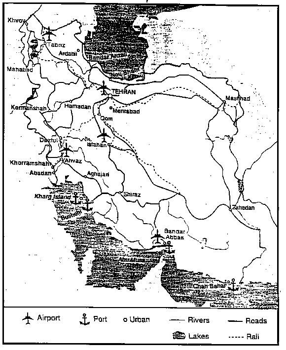
Figure 1-4. Main roadways.
b. Railroads. The Iranian State Railway faces the same problems as noted for roadways. Table 7 identified the railroad network; Table 8 identifies the main railway routes; and Figure 1-4 depicts the rail network.
Table 7. Railroad network.
|
Table 8. Main railway routes.
MAIN ROUTES
|
c. Ports. Iran's principal ports are Abadan, Bandar Abbas, Bandar Khomeini, Bandar Shahid Rejaie Chah Bahar and Kharg Island. Table 9 provides a list of Iranian ports and their capabilities. During the Iran-Iraq war, the ports located in the northern portion on the Persian Gulf were subjected to air attacks. Karg Island was extensively bombed, and sporadic attacks have occurred at other ports. Liner services are handled by The Islamic Republic of Iran Shipping Lines. Figure 1-4 identified the port locations. In 1988, Iran announced plans to spend US$200 million the construction of six multi-purpose ports on the Arabian and Caspian Seas, while at the same time repairing ports that had been damaged during the war with Iraq. The main oil terminal at Kharg Island has been repaired and is now able to load 5.5 million barrels a day. Plans exist for a six to eight million barrels a day capacity. Repairs are in progress in the main ports of Bandar Abbas and Chah Bahar (on the Caspian Sea). In December 1993, Tehran announced that salvage experts had cleared 210 ship hulks from Khorramshahr harbor and the Karun river at a cost of US$3.3 million. Iran claims that the port is now operational.
d. Air transportation. The international airport at Abadan was seriously damaged during the war with Iraq. The principal international airport of Iran is now Mehrabad, in Tehran, but there are still over 180 usable airports around the country, at least 80 of which have permanently surfaced runways (see table 10). In early 1992, the government announced that 20 airports would be modernized and that 12 new airports would be built. Table 11 provides a list of IRAN’s airfields
e. Water transportation. Approximately 904 km of waterway systems are located in Iran. The best navigable waterway is the 130 km Shatt al Arab inland waterway (under dispute between Iran and Iraq) and the adjacent Rud-e Karun (Karun River), which is navigable for 161 km (Figure 1-6). Daily motorboat and cargo services are available on Lake Urmia. This service consists of tugs and barges to carry goods and passengers between Sharafkhaneh and Golmankhaneh.
f. Pipelines. The pipeline system is utilized mainly for the movement of petroleum products and natural gas. Table 12 lists the pipeline network. The locations of the major oil and natural gas pipelines are depicted in Figure 1-6.
Table 9. Ports.
|

Figure 1-5. Airbases.
Table 10. Air transportation network.
|
Table 11. Airfields.
|
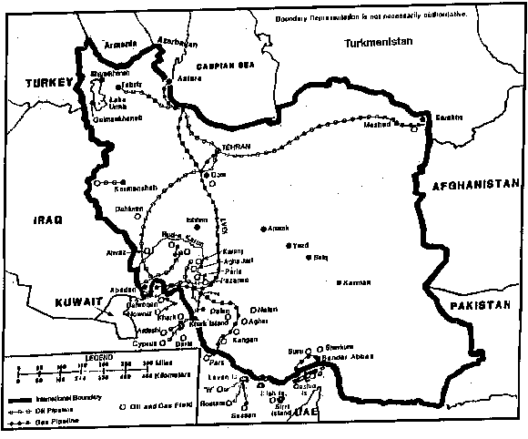
Figure 1-6. Water transportation and pipelines of Iran.
Table 12. Pipeline network.
|
PART B: MILITARY CAPABILITIES OF IRAN
1. Historical background.
a. For two decades after their defeat during World War II, the Iranian Armed Forces did not engage in regular combat. On several occasions between 1971 and 1977, however, Iran's military forces fought in small-scale operations. Limited as they were, these engagements enabled the largely untested forces to gain important combat experience. Regular border skirmishes between Iranian and Iraqi ground forces occurred during the early 1970s, with the most intense occurring between October 1972 and May 1974 when at least 10 major exchanges of fire took place. During the 1970s Iranian forces also fought in Oman where they gained additional combat experience. Iran was proud of its performance in Oman; the Dhofar Rebellion had been crushed, and the shah stated he would continue to preserve the status quo in the Persian Gulf region.
b. In 1979, the Islamic Fundamentalism Revolution toppled the Shah of Iran and brought the Ayatollah Khomeini to power. Prior to this revolution, the Iranian Army had been a modern mechanized force with a strength of 300,000 personnel. When the revolution succeeded, the army rapidly collapsed as officers were retired, purged or executed and the desertion rate rose to 60%. Under the shah, the army had been deployed in 6 x divisions and 4 x specialized combat regiments, supported by more than 500 x helicopters and 14 x hover craft. An 85% readiness rate was usually credited to the force, although outside observers doubted this claim. Following the Revolution, the army became a second rate fore as the Asdaran (Iranian Revolutionary Guard Corps (IRGC)) became the main fighting force in Iran.
c. During the Gulf War, the U.S. strategy to attack from the West ensured that when the Iraqis, made to withdraw East and North back into Iran, had to pass through well positioned and flexible Coalition lines. Since U.S. policy at the time would not allow combat units to pass, this in effect prohibited any of the Iranian fighting equipment to return to Iran. This effectively destroyed 50% of the Iranian ground forces, ending Iran's domination of the region in terms of military strength.
d. Also during the Gulf War, Iraq chose to fly a large number of it's aircraft to Iran to protect them from being destroyed on the ground by coalition forces. After the war was over the U.S. forbid the return of these aircraft to Iraq. The irony is that Iran does not have the spare parts for these aircraft and therefore it is doubtful if any are still operational. And, with the arms embargos placed on Iran as a result of their sponsorship of terrorism, there is little hope for replacement of U.S. or Russian spare parts to repair these aircraft.
e. Iran is a leading terrorist supporting nation (second only to Sudan) and is listed as such in both U.N. and U.S. foreign policy documents including a Presidential directive banning trade with Iran. Very strong U.S. intelligence evidence linked the bombing of the World Trade Center in New York City to Iranian fundamentalist-extremists. This evidence was used in the trials of those accused of the bombing, winning convictions. Iran is listed as one of the countries supporting SDT (Specially Designated Terrorists) and subject special U.S. TSRs (Terrorism Sanction Regulations). Iran is also a major divisive element in the Middle East peace recess, and as such has additional sanctions placed on them.
2. Command and control. As faqih (religious jurist), the Ayatollah Khomeini was constitutionally designated Supreme Commander of the Armed Forces. He delegated the post of Commander-in-Chief to the President of the Republic, who could in turn delegate authority as required. Important decisions regarding defense policies are made by the Supreme Defense Council (SDC), which combined senior members of the armed services with senior members of the government.
a. According to Article 110 of the 1979 Constitution of the Islamic Republic of Iran, the faqih is empowered to appoint and dismiss the Chief of the Joint Staff, the Commander in Chief of the Pasdaran, two advisers to the SDC, and the commanders in chief of ground, naval, and air forces on the recommendation of the SDC. He is also authorized to supervise the activities of the SDC and to declare war and mobilize the armed forces on the recommendation of the SDC. As faqih, Khomeini, although maintaining the role of final arbiter, delegated the post of commander in chief to the president of the Republic (Figure 1-7).
b. In addition to specifying the duties of the commander in chief, Article 110 establishes the composition of the SDC as follows: president of the country, prime minister, minister of defense, chief of the Pasdaran, and two advisers appointed by the faqih. Other senior officials may attend SDC meetings to deliberate national defense issues. In the past, the Minister of Foreign Affairs, Minister of Interior, Minister of the Pasdaran and his deputy, Air Force and Navy Commanders in Chief, War Information Office director, and others have attended SDC meetings. The ground forces commander in chief, Colonel Seyyed-Shirazi, is a member of the SDC as a representative of the military arm for the faqih, whereas Majlis (Iranian Parliament) speaker Hojatoleslam Ali Akbar Hashemi-Rafsanjani is representative of the political arm for the faqih.
c. Iran's strategic planning and the establishment of its military and defense policies are the responsibilities of the SDC, which has representatives at operational area and field headquarters to provide political and strategic guidance to field commanders. SDC representatives may also veto military decisions. However, reports in 1987 indicated that SDC orders to regional representatives were modified to limit the heavy casualty rates caused by their inappropriate advice. Inexperienced nonmilitary religious advisers have seen their interference inpurely technical matters dramatically curtailed.
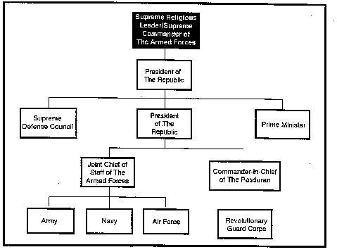
Figure 1-7. Iranian Armed Forces command structure.
d. The Urumiyeh (the town of Urmia, station for prerevolutionary officers of the 64th Infantry Division) reorganization proposals recognized the administrative separation of the services as part of Iran's political reality. Consequently as of 1987 there were two chains of command below the SDC, one administrative and the other operational. To some extent this dual chain of command existed because the revolutionary government had retained a modified version of the organizational structure of the islamic Imperial Armed Forces (IIAF), which was modeled on the United States division of powers between the administrative functions of the service secretaries and the operational functions of the secretary of defense and chiefs of staff. In addition, the Islamic Republican Party (IRP) leaders wanted to limit friction between the regular military and the Pasdaran. According to Speaker Hashemi-Rafsanjani, the service commanders in chief, the minister of defense, and the minister of the Pasdaran were removed from the operational chain to avoid further friction between the two groups.
e. In 1987 the Ministry of Defense continued to handle administrative matters for the regular armed forces. The chain of command flowed from service Commanders in Chief and their staffs to intermediate-echelon service commanders to senior unit commanders (of division, wing, and fleet). Similarly, the Ministry of the Pasdaran handled the administrative affairs of the Pasdaran. The chain of command flowed from ministry staff officers to the senior commanders (operational brigades in the case of combat units). In the case of internal security units, the chain of command went from provisional general commanders (who were generals) to provisional commanders (who were colonels) to local commanders.
f. The Joint Staff of the Armed Forces, composed of officers assigned from the various services, the Pasdaran, the National Police, and the Gendarmerie, was responsible for all operational matters. Its primary tasks included military planning and coordination and operational control over the regular services, combat units of the Pasdaran, and units of the Gendarmerie and National Police assigned to the war front. Joint Staff members were also empowered to integrate fully the regular and paramilitary forces in operational planning. The components of the Armed Forces Joint Staff were modeled on the United States joint and combined staff system (Figure 1-8).
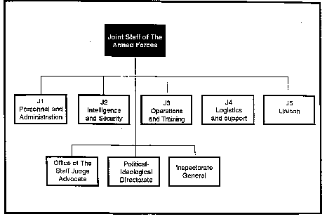
Figure 1-8. Joint Staff of the Iranian Armed Forces
(1) Staff members of J1--Personnel and Administration-- conducted planning and liaison duties with their counterparts at the ministries of defense, interior, and the Pasdaran (RGC). They also supervised budgeting and financial accountability and the preparation of operational budgets for Majlis (Iranian Parliament) approval for all the armed services.
(2) Personnel of J2--Intelligence and Security--carried out operational control for intelligence planning, intelligence operations, intelligence training, counterintelligence, and security for all elements of the armed forces. They also handled liaison with the komitehs (revolutionary committees) for internal security matters and with the intelligence branch to spy on the regime's adversaries (SAVAMA) for foreign intelligence.
(3) Staff members of J3--Operations and Training--conducted training, operational planning, operations, and communications. The operational planning and operations sections were further divided into eleven subsections for planning and coordination of the services, including: The Iranian Islamic Ground Forces (IIGF), IIGF Aviation, IIGF Chemical Troops, IIGF Artillery Troops, IIGF Engineer Troops, Iranian Islamic Air Force (IIArF), Iranian Islamic Navy (IIN), IIN Aviation, the Pasdaran, the Gendarmerie, and the National Police.
(4) Personnel of J4--Logistics and Support--coordinated and provided liaison for the services. Primary responsibility for logistics and supply rested with the services through the ministries of defense, interior, and the Pasdaran; collection and coordination of supplies and coordination of transportation to the war front, however, remained under the control of J4.
(5) Staff members of J5--Liaison--handled liaison and coordination with nonmilitary organizations and with those military organizations not covered by Joint Staff-level arrangements. Organizations covered by J5 included the Ministry of Defense, Ministry of Interior, Ministry of the Pasdaran, Office of the Prime Minister, Council of Ministers' Secretariat, SDC, Majlis (particularly the Defense and Foreign Affairs Committee), the Foundation for Popular Mobilization, the Foundation for the Disinherited, the Foundation for Martyrs (Bonyad-e Shahid), the Foundation for War Victims, and the Crusade for Reconstruction (Jihad-e Sazandegi or Jihad).
(6) The office of the Staff Judge Advocate provided legal counsel to the Joint Staff and facilitated liaison with the revolutionary prosecutor general and the military tribunal system of the armed forces.
(7) The Political-Ideological Directorate (P-ID) staff members operated the political-ideological bureaus of the Joint Staff components and the political-ideological directorates and bureaus of the operational commands. This office also developed and disseminated political-ideological training materials, in close cooperation with the Foundation for the Propagation of Islam and the Islamic associations of the services. Finally, P-ID members conducted liaison duties between the Joint Staff and the Islamic Revolutionary Court of the Armed Forces.
(8) Members of the Inspectorate General handled oversight functions over the staff components and liaison with the inspectors general of the operational commands. Special Office for Procurements staff members controlled and coordinated procurement of military equipment and supplies from foreign sources through the Ministry of Defense, the Ministry of the Pasdaran, the Ministry of Commerce and Foreign Trade, and the Central Bank of Iran.
(9) In general, operational area commands were subordinate to the Joint Staff, and each armed force component was subordinate to the operational area command in accordance with its own command structure. In 1987 there was only the Western Operational Area Command, which was responsible for the war with Iraq. Established to provide more effective control of wartime operations, this area may have been the precursor of the planned Northern, Southern, and Eastern Operational Area Commands (Figure 1-9).
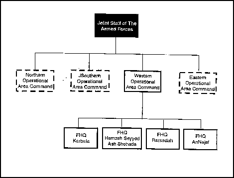
Figure 1-9. Operational area commands.
g. The Western Operational Area Command was similar in structure to the Armed Forces Joint Staff except that it was also the lowest operational echelon at which naval forces were integrated into combined-services operations and planning. Although operational area command Joint Staff members exercised operational control over all troops within their area, they were subject to several constraints. Generally speaking, Pasdaran, Gendarmerie, and National Police units operating in an internal security mission, particularly against insurgents, were detached from the operational area command and subordinated to the senior Pasdaran commander in the province in which they were engaged. Air and naval units continued to be partially controlled by their service commanders and responded to the Western Operational Area Command Joint Staff through specialized liaison staffs. The command of the operational area was further burdened by the presence at his headquarters of an SDC representative and a personal representative of Khomeini. Both of these influential individuals could effectively take any matter over the commander's head to a higher authority. In 1987 the SDC representative in the Western Operational Area Command was also the Pasdaran commander for the operational area command, a situation that further complicated the command and control system.
(1) Below the operational area command were four field headquarters (FHQ), code-named FHQ Karbala, FHQ Hamzeh Seyyed ash Shohada, FHQ Ramadah, and FHQ An Najaf. The FHQs were organized on the model of the Western Operational Area Command except that they did not have naval integration. Subordinate to each FHQ were from three to eight operational sectors. Each operational sector did not necessarily have its own air support unit.
(2) Additional echelons consisting of a commander and staff drawn from the Joint Staff of the participating FHQs could be created during major offensives. The functions of these echelons was to overcome logistical shortcomings, concentrate and deploy forces as needed, and combine the services, particularly the naval forces, in offensive operations.
3. Iranian Armed Forces.
a. Ground forces. At present Iranian ground forces include Army and Revolutionary Guard Corps (RGC) Forces; however, it appears the Pasdaran are being integrated into the regular Army. The Army is organized as shown in Table 13. Figures 1-10 - 1-12 show the force trends from 1975-1998 broken down by manpower and weapon type.
Table 13. Iranian Army units.
|
b. The Iranian air force numbers some 30,000 members, Table 14 list the air force units. The American equipment cannot be assumed to be fully operational. Additionally, some of the 113 Iraqi combat aircraft flown into Iran during Desert Storm remain but they are probably not operational either. The mission of the air force is to conduct independent air attacks against enemy targets; to participate in the defense of the country against hostile air action; and to support the ground forces and navy by air strikes, reconnaissance, and air supply and transport. See Figure 1-5 for locations of major air force bases.
Table 14. Air Force Units.
|
Copyright: Reprinted from the Military Balance 1990-91, IISS (London).
c. Naval administrative headquarters is at Bandar Abbas on the Strait of Hormuz table 15 list the Iranian naval equipment. There is a second operating base and dockyard at Bushehr. Other operating bases are at Kharg Islind (light forces), Chah Bahar (submarines) on the Indian Ocean and there is a training base at Pahlavi on the Caspian Sea. Inshore patrol craft operate from forward vases at Farsi, Sirri and Abu Musa.
Table 15. Iranian naval equipment.
|
d. Revolutionary Guard Corps (RGC).
(1) RGC ground forces are organized in 13 x regional commands. They are loosely organized in battalions of no fixed size, grouped into 21 x infantry and 2 x armored divisions and many independent brigades, including infantry, armored, parachute, special forces (SF), artillery (including surface-to-surface missile (SSM), engineer, air defense (AD), and border defense units. The RGC serves independent or with the Army and has small arms and support weapons from the Army. Furthermore, the RGC ground forces control the Basij (Mobilization of the Oppressed) during civil disturbances.
(2) RGC naval forces (strength unknown) control 5 x island bases to include Al Farsiyah, Halul (oil platform), Sirri, Abu Musa, and Larak. These forces have 40 x Swedish marine boats and control coast defense elements including artillery and SSM sites.
(3) RGC naval forces include 3 Marine brigades.
e. Paramilitary forces.
(1) Known as the Popular Mobilization Army, this volunteer force would provide the bulk of the land forces personnel in the event of mobilization. There are about 1,000,000 men and women available in times of national emergency but they are armed only with small arms. The Basij is organized into regional battalions. There appear to be two types of battalions: Ashura and Gaith. The Tehran regime plans to incorporate the estimated 175 Khorasan tribes and clans into the Basij system. In late 1994, the Basij were noted as employing rank insignia and there is now thought to be a full rank structure up to the level of Brigadier General.
(2) Gendarmerie including the border guard element.
(3) Home guard, which is controlled by the RGC.
(4) Tribal guards. Some 40 x units are reported forming.
(5) Kurds. Kurdish Democratic Party armed wing (Pesh Merga).
f. Forces abroad. There are 2,000 RGC troops reported in Lebanon.
Copyright: Reprinted from The Military Balance 1990-91, IISS (London).
g. Foreign forces. There were 400 foreign troops of the UN Iran/Iraq Military Observer Group (UNIIMOG) in Iran/Iraq from Austria (medical), Ireland (Military police), New Zealand (Air Force), and observers from 25 countries prior to Operation Desert Storm.
h. Table 16 shows the Iranian armed forces strength.
Table 16. Iranian Armed Forces strength.
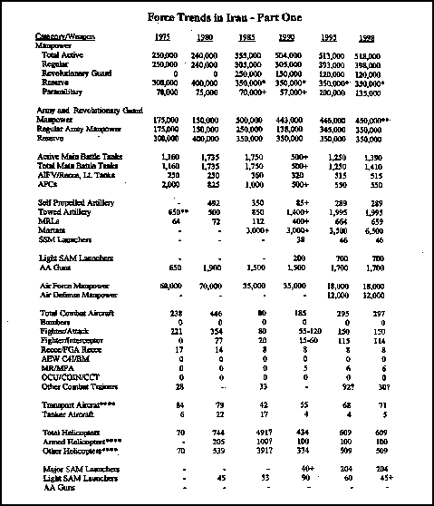
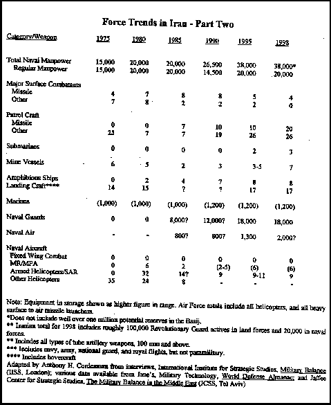
Table 16. Iranian Armed Forces strength (concluded).
Practice Exercise