

|
RDL Homepage |
Table of Contents |
Document Information |
Download Instructions |
LESSON 1
CONDUCT INTELLIGENCE PREPARATION OF THE BATTLEFIELD (IPB) ON URBAN TERRAIN
OVERVIEW
LESSON DESCRIPTION:
In this lesson you will learn to perform a specific task required in planning for and conducting a defensive operation on urbanized terrain.
TERMINAL LEARNING OBJECTIVE:
| ACTION: | Conduct Intelligence Preparation Of The Battlefield (IPB) On Urban Terrain. |
| CONDITION: | Given extracts of doctrinal literature, a tactical situation for a battalion TF S3, and a series of multiple-choice questions relating to Threat force offensive doctrine. |
| STANDARD: | To demonstrate competency of the task, you must achieve a minimum of 70% on the subcourse examination. |
| REFERENCES: | The material contained in this lesson was derived from the following publications: FM 34-130, FM 90-10-1, and FM 100-2-2. |
INTRODUCTION
Intelligence preparation of the battlefield (IPB) is key to all operations conducted in built-up areas--intelligence is an important part of every combat decision. To succeed as fighters in built-up areas, commanders and leaders must know the nature of built-up areas. They must analyze its effect on both enemy and friendly forces. The focus of the material presented will be on those issues of urban analysis that commanders and their staffs must be aware of before conducting the IPB process.
INTELLIGENCE PREPARATION OF THE BATTLEFIELD IN THE URBAN BATTLE.
1. Friendly and enemy doctrines recommend avoiding combat in built-up areas. War in Europe, Korea, or any other heavily populated area inevitably requires combat in cities. In many cases, large urban areas cover major lines of communication, or sit astride main supply routes. These urban areas will have to be attacked or taken to further the advance or to effect the continual flow of supplies. Political rather than military considerations may dictate the methods employed in the effort.
2. Additionally, the increasing focus on operations other than war (OOTW), urban terrorism, and civil disorder adds to the realization that more attention must be given to urban combat. This is especially true in the case of urban insurgency, which has become a well-organized strategy. Urban insurgencies currently being carried out in various parts of the world are causing serious problems for the authorities; they have forced the militaries to develop new strategies to cope with this growing problem. The refinement of IPB doctrine to include operations other than war including urban combat operations is a direct result of our realization of the actual situations that will be encountered.
3. The requirements for combat in built-up areas create a variety of troop control, maneuver, and equipment utilization problems. Urban combat also imposes a number of demands that are different from ordinary field conditions. These specific demands include requirements for:
a. Larger forces.
b. A slower pace and tempo of operations, and an increase in methodical, synchronized operations.
c. A longer duration of commitment.
d. Longer preparatory and counter-preparatory fires.
e. Almost constant communications between individual forces.
4. Urban defensive operations and insurgent and terrorist actions depend on the holding or attack of critical areas. During actual combat these critical sites provide stability for the defense and are the basis for freedom of maneuver. Insurgents and terrorists rely on such areas to provide a basis for further operations and to spread counterterrorist or counterinsurgent forces over a wider area. No matter which situation applies, combat in urban terrain is expected to break down into a number of small-unit battles fought by battalions, companies, platoons, and squads or small assault groups in confined areas. These conditions create:
a. The requirement to fight small-scale engagements which inhibits centralized control and forces independent action by small unit leaders. This especially impacts on the former Soviet preference for close centralized control and large-scale operations.
b. The problem of training small units for combat in urban areas and other inherent and probably unanticipated difficulties is maintaining morale.
c. Confined spaces which limit observation, fields of fire (FofF), and maneuver.
d. The inability to maneuver which prevents the concentration of fire maneuver elements at critical points.
e. A greater demand for ammunition and rations, thus imposing unusual strains on logistics elements.
f. Problems with conducting effective reconnaissance during conventional operations. Reconnaissance by force becomes the most effective reconnaissance means. This method involves probing a defense with successively larger units until the enemy positions are disclosed and can be successfully attacked. During unconventional operations, the opposite is true. Reconnaissance and security (R&S) are easily accomplished by both sides and may be unstoppable.
g. Limitations in the ability to employ maximum combat power. Effective employment of firepower may be limited by the requirement to minimize damage. The terrain in the urban area can be expected to change during the battle, thereby complicating terrain analysis efforts. Urban terrain provides many small unit infiltration and movement routes which would not be considered during open area combat.
h. Situations in which small unit defensive positions can slow or stop the advance of a considerably larger force, and will require disproportionate efforts to be reduced.
5. All of these problems are expected to have a significant impact on the IPB process. Battlefield area analysis will assume an entirely different focus. The normal terrain evaluation process will require significant modification. Most weather factors will have less impact on operations. However, light data will assume a much greater importance. Familiar Threat doctrine will not apply to urban terrain and weapons system capabilities will be seriously degraded. The extreme potential for diversity in applying doctrine to urban terrain increases the difficulty of developing situation and event templates. The slower pace, smaller size, and increased numbers of operations will reduce or negate the effectiveness of time phasing. In addition, the matrix of streets makes the identification of target areas of interest (TAIs) and decision points (DPs) extremely difficult. The composition of the built-up area will determine how the IPB effort must be focused. A city with a major commercial area and multi-story buildings will require a significantly different focus than a town of single-story residences or a major industrial and rail center.
BATTLEFIELD AREA EVALUATION
1. Battlefield area evaluation for the urban battle involves the analysis of the urban area and a definition of the actual area to be considered. Questions to consider are:
a. Is the mission offensive or defensive?
b. Is the Area of Operation (AO) a typical European town with narrow streets, circular configuration, and low-terrain location?
c. Is the AO a Korean city with cities within a city, terrain-covering sprawl, and outlying industrial areas; or a major commercial, railroad, and navigation center with urban sprawl, and numerous light and heavy industries?
d. Is the threat a conventional force, an urban insurgency, a terrorist group, or a guerrilla war that has spread to the urban area?
e. What are the political considerations of the operation?
2. Built-up areas are normally classified by size. The former Soviets also classify cities by size and include the estimated perimeter of the city. US doctrine for classification also includes the built-up areas which form the connecting links between villages and towns. These strip areas are found along lines of communication (LOCs). Figure 1-1 shows both the US and the former Soviet urban area classification criteria.
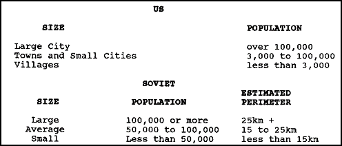
Figure 1-1. US and the former Soviet urban area classification criteria.
3. In addition to being classified by size, areas within cities and towns are classified by individual building and street layout patterns. These patterns have been categorized into five basic layouts which recur consistently throughout Europe, and which have parallels in Korea, Japan, and the Middle East. The five patterns are:
a. Dense, random construction.
b. Closed-orderly block.
c. Dispersed residential area.
d. High-rise area.
e. Industrial or transportation.
4. Dense, random construction is the typical old inner-city pattern. Narrow winding streets radiate from a central area in an irregular manner. Buildings are closely located and frequently are close to the edge of the roadway. This pattern is found in cities, towns, and villages throughout Europe and Korea.
5. The closed-orderly block pattern is common to the central areas of towns and cities. Wider streets generally form rectangular patterns. Buildings frequently form a continuous front along commercial areas in Europe, this pattern will likely be interspersed with light industrial or high-rise areas in Korea and Japan.
6. The dispersed residential area is normally contiguous to close-orderly block areas in Europe. The pattern consists of row houses or single-family dwellings with yards, gardens, trees, and fences. Street patterns are normally rectangular or curving. Such areas are limited to upper-class areas in oriental cities and towns.
7. The high-rise area is typical of modern construction in larger cities and towns. It consists of multi-storied apartments, separated open areas, and single-story buildings. Wide streets are laid out in rectangular patterns. These areas are often contiguous to industrial or transportation areas or interspersed with closed-orderly block areas.
8. Industrial or transportation areas are generally located on or along major rail and highway routes in urban complexes. Older complexes may be located within dense, random constructions or closed-orderly block areas. New construction normally consists of low, flat-roofed factory and warehouse buildings. High-rise areas providing housing for workers are normally located adjacent to these areas throughout the orient. Identification of transportation facilities within these areas is critical. These facilities, especially rail facilities, pose significant obstacles to military movement.
9. The AO in urban warfare, like the normal AO, is assigned by higher headquarters. Like the normal AO, it is defined by depth, frontage, and height (airspace). Unlike the normal area, it also includes underground operations. Sewers, basements, subways, and underground cisterns and reservoirs force an entirely different analytical focus. Tall buildings add a new dimension to airspace analysis, both from a perspective of the FofF they permit and their effects on aircraft and air defense operations.
10. The areas that interest the commander will still be based on the commander's concept of the operation and METT-T factors. However, the commander will have to alter his areas of interest to include access and withdrawal routes into and out of the built-up area. Particular attention should be directed to routes where withdrawal can be blocked by obstacles or by airlanded forces. The area should also include all potential underground routes into the commander's AO. This will preclude an enemy force from appearing in an area that has already been cleared.
11. The battlefield evaluation must include a detailed examination of the enemy force that is expected to be encountered. Operations against an enemy motorized rifle battalion (MRB) will differ significantly from operations against a light infantry, insurgent, or terrorist force. Each will require a different mix of forces and tactics. Urban guerilla and terrorists represent entirely different situations which require special techniques. The nature of the enemy, together with the political considerations involved, will determine how commanders will employ their forces in the urban environment.
12. Another primary consideration is that every city is different. Therefore, battlefield evaluation must be concerned with the specific characteristics of each urban area rather than the general nature of the AO. The evaluation must also consider that urban operations will reduce both friendly and enemy operational capabilities by inhibiting fire, maneuver, and jamming potential.
13. Finally, the evaluation must consider that in no other form of combat are the pressures of battle more intense. Continuous close combat, high casualties, and the fleeting nature of targets and fires from a frequently unseen enemy produce severe psychological strain and physical fatigue, particularly among soldiers and small unit leaders.
TERRAIN ANALYSIS
Terrain analysis for the urban battle differs significantly from that of open country. Although the five military aspects of terrain are still considered, the familiar rules of terrain analysis cannot be applied to the urban environment. The normal graphic terrain products, such as modified combined obstacle overlay (MCOO), with its depiction of NO-GO, SLOW-GO, key terrain, obstacles, and avenues of approach or mobility corridors, has no application to urban combat. Rather, it means that an MCOO must be developed for the urban battle, and the focus of the analysis of the terrain must be altered to consider the special implications of urban terrain.
SPECIAL CONSIDERATIONS
1. Military maps, normally the basic tactical terrain analysis tool, do not provide sufficient detail for urban terrain analysis. Military maps also have too small a scale and are normally too outdated to be useful for purposes more detailed than general urban pattern analysis. Standard city maps are the basic tool of urban terrain analysis. However, urban terrain is dynamic. Towns and cities are constantly growing, adding new structures and demolishing existing structures. Therefore, any map of an urban area, including city maps or plans published by the city, state, or national government, will be inaccurate and obsolete to some degree. As such, photo-mosaics should be constructed for use in conjunction with or in lieu of city maps to support urban terrain analysis.
2. The nature of combat can radically alter the terrain in an urban area in a very short time. Incidental or intentional demolition of structures can change the topography of the area radically, quickly destroying reference points, creating obstacles to mobility, and providing the defenders with additional defensive positions. As urban areas grow, street patterns often change, presenting an attacking force with additional withdrawal routes to block with obstacles or maneuver elements and a defending force with additional withdrawal and reinforcement routes.
3. Maps and diagrams of sewer systems, subway systems, underground water systems, elevated railways, mass transit routes and utility generation, and holding and transmission facilities are important during urban operations. Sewer and subway systems provide covered infiltration and small unit approach routes. Elevated railways and mass transit routes provide mobility between city sectors, and point to locations where obstacles might be expected. Utility facilities are key targets for insurgents, urban guerrillas, and terrorists, and their destruction can hinder the capabilities of a defending force.
4. Certain public buildings must be identified during the terrain analysis phase of urban IPB. Hospitals are critical because the laws of war prohibit their attack when not being use for military purposes other than medical support. As command and control (C2) breaks down during urban operations, hospitals become an important source of medical support to combat forces. Platoons, squads, and individual fire teams will frequently be deprived of medical support, and the availability of civilian hospitals may determine whether or not injured personnel survive. The same is true during insurgency, urban guerilla, or terrorist actions. Knowledge of the location of civilian hospitals, clinics, and surgical facilities is critical in dealing with civilian and military casualties.
5. Stadiums, parks, sports fields, and school playgrounds are of high interest during both conventional and unconventional urban operations. These provide excellent civilian holding areas, interrogation centers, insurgent segregation areas, and enemy prisoner of war (EPW) holding facilities. These open areas also provide excellent helicopter landing sites which can be employed for air assault, medical evacuation, air insertion, and air-assisted C2. As these areas are often centrally located within a city or city district, they provide excellent logistic support areas and offer excellent air resupply possibilities.
6. Construction sites and commercial operations such as lumber yards, brick yards, steel yards, and railroad maintenance yards are of high interest, especially during unconventional operations. These serve as primary sources of obstacle construction materials when rubble is insufficient or not present. They can also provide engineers with materials to strengthen existing rubble obstacles or with materials for antitank hedgehogs or crib-type roadblocks.
7. Public baths, swimming facilities, cisterns, and reservoirs are of special interest. They are especially useful in providing bathing facilities for combat personnel, thus helping to maintain morale in a situation which contributes to rapid morale deterioration. The conditions prevalent in urban combat often cause personnel to become dirtier more quickly than during combat in open areas. These facilities also provide an alternate water source when public utilities break down. Public latrines can also assist in morale maintenance, but are often connected to the utility systems which are the first to break down in conventional operations.
URBAN PATTERNS
The layout of an urban area will normally follow a definite pattern which is easily identified. Terrain analysts recognize three basic patterns and two basic subpatterns. The identification of the specific pattern or subpattern is an integral part of the urban terrain analysis process.
1. Hub Phenomenon. The hub or built-up area is central to any urban pattern. Although it may vary in size, the effects remain constant. The hub may serve as the pivot or anchor point for a defense, or as an element of a defense in-depth. The hub is an obstacle which block's the attacker's advance. When terrain permits, the hub will normally be bypassed. As the attacking force slides off the leading edge of the hub, it becomes vulnerable to flank attacks and ambushes along the new axis of advance. Where adjacent terrain is unsuitable for bypass operations, the hub may be developed as a defensive strongpoint. Attack then requires a significant increase in forces and results in intensive combat in the built-up area. Figure 1-2 shows an example of a hub phenomenon.
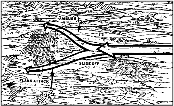
Figure 1-2. Example of a hub phenomenon.
2. Satellite Pattern. This pattern consists of a central hub and dependent, dispersed, smaller built-up areas with linear arrays along the connecting links. Links tend to focus on the central hub, with most taking the form of farm, forest, or secondary roads. Normally only a single main route will pass through the central hub. Figure 1-3 shows an example of a satellite pattern. The pattern provides a mutual support situation for urban combat by providing:
- Resupply and evacuation routes for the defenders.
- Reinforcement routes for the defenders; avenues of approach or mobility corridors for the attackers.
- Mutually supporting defensive battle positions.
- Multiple exit links from the hub for the attacking force.
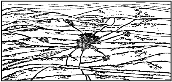
Figure 1-3. Example of a satellite pattern.
3. Network Pattern. This pattern is similar in appearance to the satellite pattern but is more complex and diverse. The pattern represents the interlocking of the primary hubs of satellite patterns. Formed primarily of towns and cities, its elements are more self-sufficient and less supportive of each other, although a dominant hub may exist. Major LOCs within a network are more extensive than in a satellite and may take on a rectangular rather than convergent form. The natural terrain within a network may be more varied than that contained in a single satellite array. The network pattern causes attacking units to have to fight through a maze of synthetic features that provide defensive obstacles. By-pass is difficult because contiguous terrain is often unsuitable for mounted operations. The pattern provides depth to the defense. Figure 1-4 shows an example of a network pattern.
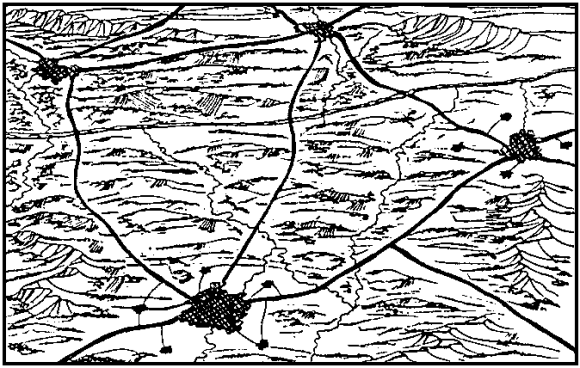
Figure 1-4. Example of a network pattern.
a. Linear Pattern. This pattern is a sub-element of the three basic patterns. The linear array may form one or more rays of the satellite pattern or the connecting links of a network. More frequently the basic array results from the stringing of minor hubs along a confined natural terrain corridor. This pattern facilitates the development of a series of strong defensive positions in-depth. It also acts to delay canalized forces and requires repeated deliberate attacks.
b. Segment or Pie-Slice Pattern. This pattern may occur as a subset of either the satellite or network patterns, or within a major hub. It is characterized by the splitting of an urban area by a dominant natural terrain feature such as a river or by synthetic features such as roads, railroads, and canals. The pattern may influence the assignment of boundaries and other control measures, or of attack objectives. The pattern may also bear directly on the organization of the terrain and on task organization. Figure 1-5 shows an example of a segment or pie-slice pattern.
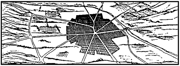
Figure 1-5. Example of a segment or pie-slice pattern.
PATTERN EFFECTS
In addition to the basic blocking action caused by the hub phenomenon, other effects can be associated with urban patterns.
1. The Funnel-Fan Effect. This normally occurs when the hub is located between terrain features that are unsuitable for mounted operations. Movement of units into the area results in the concentration of forces, a loss of offensive momentum, and canalization. Beyond the hub, forces are required to spread or fan out before full combat power can be developed. This favors the defense because it creates an accordion effect in units moving through the hub, reducing C2 and operating effectiveness. A similar effect occurs when an attacking force must penetrate an urban network on a narrow front between hubs. Figure 1-6 shows an example of a funnel-fan effect.
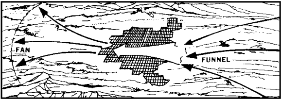
Figure 1-6. Example of a funnel-fan effect.
2. The Funnel Effect. Funneling or concentration and canalization of forces may occur without immediate fanning. This occurs most frequently when the linear pattern is encountered. It limits the number of maneuver units that may be applied against a series of hubs that must be confronted in succession, and forces a greater reliance on long-range and indirect fire weapons.
THE MILITARY ASPECTS OF TERRAIN
Urban terrain is analyzed by the five military aspects of terrain, the individual building and street layout pattern, and the echelon of the friendly unit. For example, a brigade may be concerned with an entire city, town, or city district, while battalions or task forces may be concerned with city blocks or even with individual buildings. The restrictive nature of urban terrain forces the analyst to be concerned with minimum rather than maximum weapons ranges, as some weapons that are highly effective in open country are unusable in urban areas. The five military aspects of terrain are discussed below according to the five street layout patterns.
1. Observation and Fields of Fire.
a. Dense Random Construction. Weapons ranges and observation distances seldom extend more than 100 meters. Narrow streets limit tank turret traverse and do not allow for minimum antitank guided missile (ATGM) ranges. Buildings and narrow streets restrict the deployment of heavy direct-fire weapons. Short observation and FofF distances necessitate assigning small sectors to defending units.
b. Closed-Orderly Block. Observation and FofF extend up to 350 meters and are sufficient for heavy direct-fire weapons and ATGMs in most areas. Streets and open areas permit the establishment of normal supporting fires. Indirect fire observation will be limited by numerous tall buildings and smoke.
c. Dispersed Residential Areas. Weapons ranges are often reduced to less than 250 meters by winding streets. Straight streets sections often extend the weapons range. Buildings, hedges, bushes, walls, and other obstructions limit the effectiveness of small arms, ATGMs, and heavy direct-fire weapons. The defender can establish mutually supporting fires while the attacker cannot.
d. High-Rise Areas. Mutually supporting fires can be established between buildings during both offensive and defensive operations. Maximum weapons ranges can be achieved by positioning weapons in the upper stories of buildings.
e. Industrial or Transportation Areas. Quite often, these areas are situated on the outskirts of cities. Open areas provide excellent observation and FofF over the entire area, and facilitate the employment of close air support (CAS) and indirect fires. Smoke from burning fuel storage may hinder accurate fire direction.
2. Concealment and Cover.
a. Dense, Random Construction. Buildings provide numerous concealed infantry positions and isolated armored vehicle positions. Thick masonry--stone and brick walls--offers excellent protection from direct fire. Adequate overhead protection is found only in basements, as most roofs, ceilings, and floors are constructed of wood or plaster. Underground systems offer excellent protection and often permit movement between battle positions.
b. Closed-Orderly Block. Heavy construction provides excellent protection against direct and indirect fires. However, buildings selected for shelter must be evaluated for their ability to withstand collapse. Underground systems are normally extensive and provide storage areas, protection, and mobility.
Those underground systems not used must be blocked by either obstacles or maneuver elements. Advancing along open streets courts disaster and should be avoided whenever possible.
c. Dispersed Residential Areas. Limited concealment and cover are provided by walls, fences, hedges, and houses. Overhead protection varies, but basement positions usually provide sufficient overhead cover. Construction often permits the concealment of, and provides limited cover for, armored vehicles.
d. High-Rise Areas. High-rise structures provide protection from indirect fires, but only limited protection from direct fires. Concealment and cover are often not available unless adjacent buildings are secured. Attacking forces must employ heavy covering fire, smoke, and rapid movement to move from one building to another.
e. Industrial or Transportation Areas. Little concealment and cover are available in these areas due to the construction and the dispersed nature of the buildings. Some concealment is offered by buildings, but shed-type buildings should be avoided.
3. Obstacles.
a. Dense, Random Construction. Narrow streets with buildings constructed directly on the street facilitate construction or creation of obstacles. Demolition of structures creates instant rubble obstacles.
b. Closed-Orderly Block. The wider streets and heavy construction make rubble less of an obstacle. Obstacles are difficult to construct, but once constructed are difficult to reduce or bypass because of the relative ease by which they can be controlled by fire.
c. Dispersed Residential Areas. Rubble is not a significant obstacle. Most obstacles in streets can be bypassed easily, but will reduce mobility to some degree.
d. High-Rise Areas. Mines between buildings are the most effective obstacles. Rubble will not be a factor unless major structures are totally destroyed.
e. Industrial or Transportation Areas. Railyards, elevated rail and roadways, ramps, loading docks, numerous high-tension lines, canals, overpasses, pipelines, and overhead obstructions such as cranes create significant obstacles to movement. Armored vehicles should avoid railyards whenever possible, as tracks will quickly damage vehicles and the open yards themselves provide excellent defensive FofF. Rubble that may be present is normally easily bypassed.
4. Key Terrain.
Examples of urban key terrain include:
- Subway systems.
- Sewer systems.
- Underground water systems.
- Utility (gas and electric) generation, holding, and transmission facilities.
- Telephone exchanges.
- Radio and television stations.
- Rail and transit service connecting points.
- Stadiums, parks, sports fields, and school yards.
- Tall buildings (rooftops).
5. Avenues of Approach.
Avenues of approach are analyzed for battalion and smaller unit operations as the battalion is the most effective force of any size that can be employed under urban conditions. Avenues of approach are dictated by the urban pattern and the actual mission. Urban avenues of approach will cover unusually narrow frontages and, when possible, multiple avenues will be employed to permit flanking and rear attacks in support of the main effort Figure 1-7 shows typical avenue of approach widths for the five basic types of urban terrain.
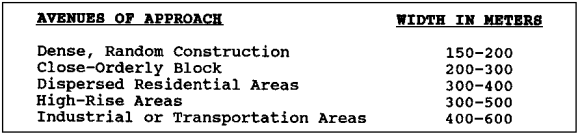
Figure 1-7. Avenue of Approach widths.
URBAN MCOO DEVELOPMENT
1. If maps of the urban area are available, an MCOO is prepared. The MCOO shows construction patterns and depicts known obstacles and avenues of approach or mobility corridors. A MCOO can also be prepared using photographic maps of the city. If maps are not available, imagery of the build-up area should be annotated with the information. Figures 1-8 and 1-9 show examples of urban MCOO development.
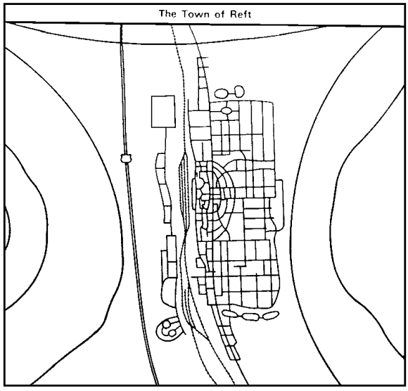
Figure 1-8. Example of an urban MCOO development.
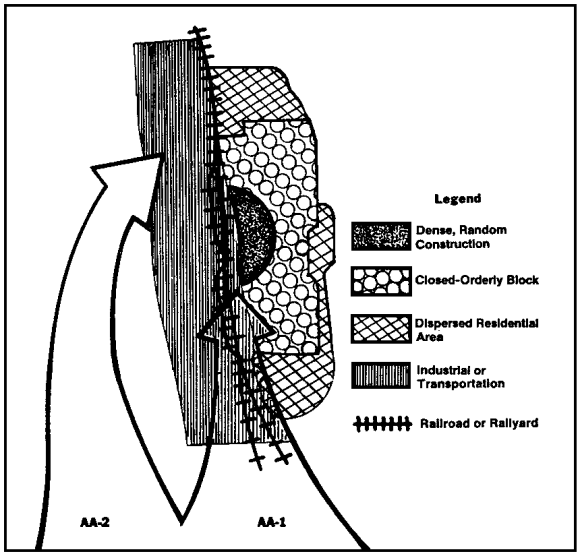
Figure 1-9. MCOO for the town Reft.
2. An avenue of approach or mobility corridor overlay for urban underground systems should be prepared when appropriate. This is required where the underground systems (sewer, water, subway, gas, steam, or telephone) have pipes, tunnels, or culverts large enough through which an individual can crawl. The overlay should show the size of the tunnels, pipes, and culverts and their approximate orientation. Color coding helps to distinguish systems of various types and sizes. When possible, subsurface avenues of approach or mobility corridors should be prioritized based on the likelihood of their use. Figure 1-10 shows an example of an underground systems overlay.
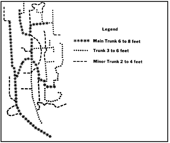
Figure 1-10. Example of an underground systems overlay for the town of Reft.
WEATHER ANALYSIS
1. Weather analysis for urban operations does not differ significantly from open terrain weather analysis. However, a few special considerations peculiar to the urban environment must be taken into account.
2. Rain or melting snow will often flood basements and subway systems. This is especially true when automatic pumping facilities that normally handle rising water levels are deprived of power. Rain will also make storm and other sewer systems hazardous or impassable. Chemical agents will be washed into underground systems by precipitation. These systems will, as a result, contain agent concentrations much higher than surface areas and will become contaminated hot spots. These effects will become more pronounced as agents are absorbed by brick or unsealed concrete sewer walls.
3. Many major cities are located along canals or rivers. This often creates a potential for fog in the low-lying areas. Industrial or transportation areas are often the most affected by fog due to their proximity to waterways.
4. Air inversion layers are common over cities, especially cities which are located in low-lying bowls or in river valleys. Inversion layers trap dust and other pollutants, reducing visibility, and often creating a greenhouse effect which causes a rise in ground and air temperatures.
5. The heating of buildings during the winter and the reflection and absorption of summer heat make built-up areas warmer than surrounding open areas during both summer and winter. This difference can be as great as 10 to 20 degrees, and can add to the already high logistics requirements of urban combat.
6. Windchill is not as pronounced in built-up areas. However, the configuration of streets, especially in closed-orderly block and high-rise areas, can cause wind canalization. This increases the effects of the wind on streets which parallel the wind direction, while cross-streets remain relatively well protected.
7. Light data has a special significance during urban operations. Night and periods of reduced visibility favor surprise, infiltration, detailed reconnaissance, attacks across open areas, the seizure of defended strongpoints, and the reduction of defended obstacles. However, the difficulties of night navigation in restrictive terrain, without reference points, and in close proximity to the enemy, forces reliance on extremely simple maneuver plans with easily recognizable objectives.
THREAT EVALUATION
1. Threat evaluation for urban combat uses the same three-step process: developing a threat data base, determining enemy capabilities and developing a doctrinal template file as threat evaluation for open terrain. However, the focus of the evaluation effort is largely directed toward battalion-sized and smaller operations, as units of this size are considered the most effective for urban operations.
2. The decision for threat forces to attack an urban area may be based on tactical, operational, or political considerations and is normally made at Army level or above. Threat forces may attack built-up areas to:
a. Secure political, industrial, logistic, or communication facilities.
b. Destroy defending forces within a built-up area.
c. Gain passage through an urban area that cannot be by-passed.
3. While recognizing the requirement to defend built-up areas, threat forces always attempt to establish a defense well forward of an urban area in order to engage and defeat the attacker on the approaches and flanks of the built-up area. Threat forces revert to the conduct of defense within a built-up area only when:
a. Attacking forces break through defenses organized forward.
b. The built-up area has especially great political, strategic, or economic importance.
c. It is necessary to defend a built-up area which is a sea-port, or other critical communications or transportation complex.
4. For both offensive and defensive operations, the Threat considers the motorized rifle battalion (MRB) the most effective unit for urban combat because of its inherent mobility, armor protection, and rapid ability to adapt buildings and other structures for defense. The battalion coordinates closely with units from other arms which attach elements or provide support or security. The battalion will be reinforced by other elements depending upon the mission and the expected conditions in the urban area.
5. During the attack, the MRB is reinforced with a tank company, a battalion of self-propelled artillery for direct fire, an engineer company, and a chemical reconnaissance section. An additional artillery battalion will be placed in direct support to provide indirect fire. Missions normally assigned to an MRB as the first echelon of a main attack are to:
a. Seize immediate objectives on the edge of the city.
b. Attack along primary routes to secure deep objectives and key facilities.
c. Figure 1-11 shows a doctrinal template for an MRB as the first echelon of a main attack. The battalion assaults in column.
6. Second-echelon MRBs are also reinforced with tanks, artillery, and engineers. This provides for rapid replacement of the first echelon without having to reassign units during combat. Missions normally assigned second-echelon MRBs are to:
a. Reinforce the first echelon.
b. Be prepared to assume the first echelon mission.
c. Provide replacements for combat ineffective first-echelon units.
d. Reduce bypassed enemy defensive positions.
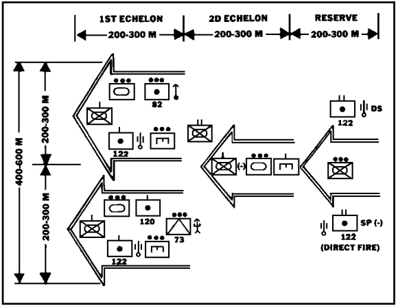
Figure 1-11. Example of an attack of built-up area by reinforced MRB (main attack).
7. Reserve MRBs are prepared to:
a. Pass through either echelon to exploit defensive weaknesses.
b. Protect the flanks.
c. Conduct firefighting and debris clearing missions as required.
8. Motorized rifle companies (MRC) may be designated as assault groups. Companies conducting the main attack are reinforced with a tank platoon, an artillery battery, chemical, and flame thrower units, and an engineer platoon. Frequently, battalion antitank assets will also be attached to the company making the main attack.
9. Attached elements are further attached to platoons, providing each platoon with at least one tank or artillery weapon and some engineer support. These attachments allow decentralized or independent operations by individual platoons in seizing specific objectives. Figure 1-12 shows the doctrinal configuration for a motorized rifle platoon (MRP) assault on an urban strongpoint.

Figure 1-12. Example of an MRP assault on an urban strongpoint.
10. Night operations are stressed to maintain uninterrupted momentum and to reduce casualties during the urban battle. Night operations against built-up areas are conducted to:
a. Bypass outlying villages being used as defensive positions.
b. Seize initial objectives on the edge of the built-up area when required to attack across open ground.
c. Attack across broad streets, parks, or between buildings.
d. Seize heavily defended strongpoints.
c. Reduce street obstacles that are well covered by fires and protected by mines.
d. Exploit daylight successes by keeping pressure on the defense.
11. Reconnaissance units will attempt to infiltrate night objectives to obtain information and-to guide assault forces to the objectives. Assault groups normally attack in a single echelon with units deployed on line. Supporting fires are withheld until the assault is detected. Once the attack has been detected, artillery illuminates the objective, and attached tanks and artillery suppress defenses with direct fires.
12. When surprise cannot be achieved, night assaults may be preceded by direct tank and artillery fires. Artillery and mortars seal off the objective to prevent withdrawal or reinforcement. Illumination is used to guide forces, illuminate the objectives, and dazzle night vision devices.
13. Threat evaluation is similar to that for OOTW during urban counterinsurgency (COIN), counterguerrilla, and counterterrorist operations.
14. Population status overlays are prepared for the city showing potential neighborhoods or districts where a hostile population may be encountered. Overlays are also prepared showing insurgent or terrorist safe houses, headquarters, known operating areas, contact points, and weapons supply sources. These overlays must include buildings which are known or have the potential to be explosives, ammunition, or weapons storage sites.
15. Underground routes are of primary concern when considering insurgent and terrorist avenues of approach and LOCs. Sewers, subways, tunnels, cisterns, and basements provide mobility, concealment, cover, and storage sites for insurgents and terrorists. Elevated railways, pedestrian overpasses, rooftops, fire escapes, balconies, and access ladders provide mobility and concealment and can serve as relatively good fighting and sniping positions.
16. Although doctrinal templates are not developed for urban insurgency and terrorist operations, pattern analysis will reveal how the insurgent or terrorist group operates, and what are its primary targets. Once the group's modus operandi (MO) has been determined, insurgent situation maps (SITMAPs) that pinpoint likely sabotage, kidnap or assassination targets, ambush points, and bombing targets can be developed. When developing these SITMAPs, the following should be considered as primary insurgent and terrorist targets:
a. Electric power generation and transmission facilities.
b. Gas production and holding facilities.
c. Water and sewer pumping and treatment plants.
d. Telephone exchanges and facilities.
e. Radio and television stations.
THREAT INTEGRATION
1. Threat integration for the urban battle is accomplished through the development of situation, event, and decision support templates during mid- and high-intensity conflict situations. During OOTW and terrorist situations, the decision support template (DST) normally is not developed. A decision support matrix which equates insurgent or terrorist capabilities with potential activities may be prepared. However, it cannot be stressed too heavily that indicators of insurgent or terrorist activity do not necessarily equate to actual insurgent or terrorist operations. It is possible to prepare an insurgent or terrorist decision support matrix which has multiple indicators of activity and to have no actual activity. It is also possible, and quite normal, to have no indicators of activity prior to an operation or for the visible indicators to point to the wrong area or target.
2. For conventional operations, situation templates, like doctrinal templates, focus on the MRB as the primary urban combat force. However, situation templates for operations down to platoon size may have to be developed. The actual echelon of the force depicted on the situation template will depend on the actual operation and the mission of the friendly unit.
3. During offensive operations, the MRB attacks in a series of bold, rapid movements along at least one primary route and one secondary route to secure assigned objectives. Buildings are not searched or secured unless resistance is strong. Bypassed defenders are left to following echelons. If the first echelon is stopped or slowed, the following echelon or reserves may be committed around engaged forces, and continue to the objective. Figures 1-13 and 1-14 provide examples of situation templates for attack along a primary and secondary route and for bypass operations.
4. Situation templating for insurgent or terrorist operations must consider that groups will often conduct multiple operations simultaneously within a given area. Some of these operations may be diversionary, designed to detract attention away from the primary objective. More often, they are designed to force authorities to deal with several incidents at once, thus creating the illusion that they are unable to cope with the situation.
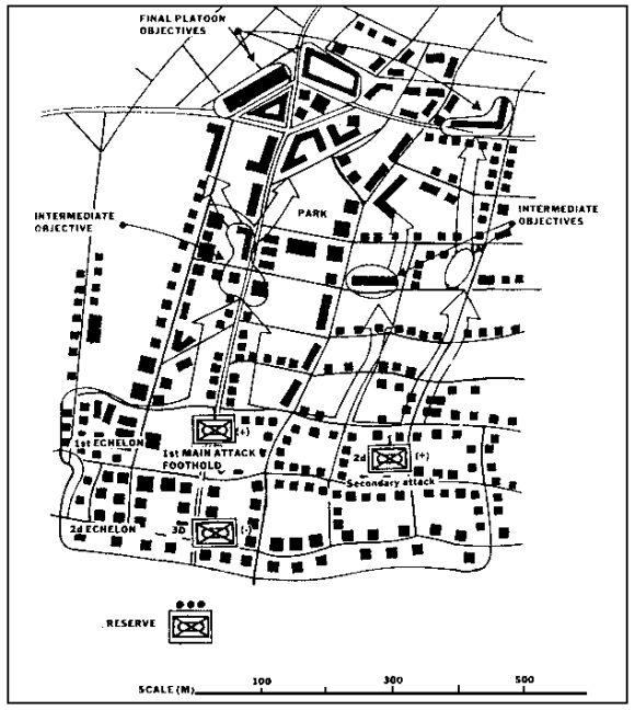
Figure 1-13. Example of an MRB attack in a built-up area.
5. Event templating for urban operations must be keyed to terrain, as keying named areas of interest (NAIs) to actual events has limited utility in a slow-moving urban battle.
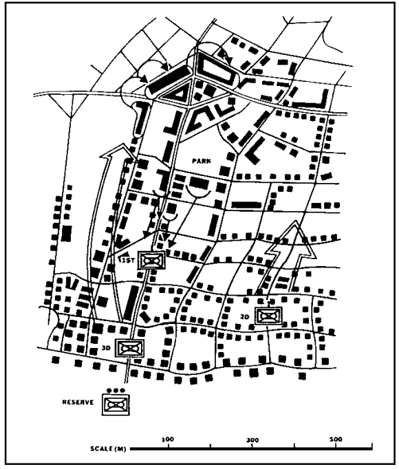
Figure 1-14. Example of a 2d echelon committed around engaged 1st echelon.
6. During enemy offensive operations, event templating must focus on the enemy's attack routes, where and when the second echelon will probably be committed, and how the second echelon will attempt to bypass stalled first-echelon elements. Because NAIs may be individual buildings, they may be closer together than in normal open-country operations. However, they perform the same functions of confirming or denying an enemy course of action and serving as the basis for directing the collection effort. Troops in contact, scouts, patrols, agents, line-crossers, and interrogators are often the most effective collection assets in the urban battle, although timeliness becomes a factor. Together with aircraft, these assets are a primary consideration when developing NAIs for urban operations. Figure 1-15 is an example of an urban battle event template for an enemy attack.
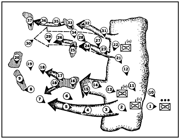
Figure 1-15. Example of an urban battle event template.
7. DSTs for urban operations must be the direct result of war-gaming. As with situation and event templates, the DST will normally deal with an area less than 1,000 meters square. As it normally covers a relatively small area and deals with exceptionally slow-paced operations, the DSTs will only rarely rely on time-phase line (TPLs) to key decisions. However, cross streets which run perpendicular to the axis of advance may take the place of TPLs. Street intersections, open areas, or individual buildings may also serve as DPs, especially when street patterns are not rectangular. DPs must consider the slower pace of urban operations, and not be places too far in advance or too close to the TAI to which they are keyed.
8. It is exceptionally critical to prepare an enemy DST for urban operations. The restrictive nature of the terrain limits freedom of action to such an extent that the commander must be able to determine enemy options at a glance. When possible, the enemy DST should be developed on, or as an overlay to the friendly DST. It is also possible to develop a combined friendly and enemy DST and operating factors matrix with decisions or counter-decisions keyed to points, events, or TPLs. As night operations are heavily stressed to achieve surprise in urban warfare, the analyst may consider developing separate DSTs for day and night operations. Factors to consider when developing night DSTs are:
a. Infiltration.
b. Increased reconnaissance.
c. A generally more rapid pace of operations.
d. A reliance on stealth and illumination.
9. Figure 1-16 shows an example of a friendly DST. Figure 1-17 shows an example of an enemy DST.
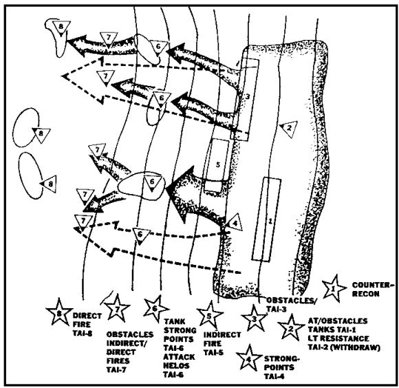
Figure 1-16. Example of a friendly DST (enemy attack).
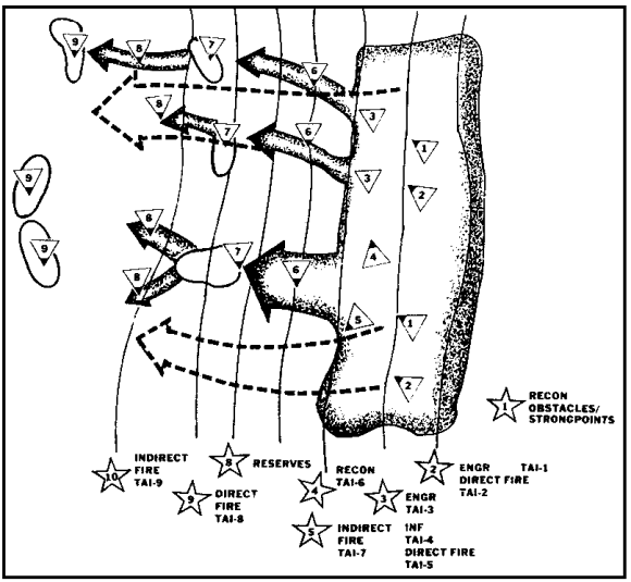
Figure 1-17. Example of an enemy DST.