

NAVSTAR GLOBAL POSITIONING SYSTEM (GPS)
 |
The NAVSTAR Global Positioning System (GPS) is an Air Force-managed Joint Service program that provides highly accurate, real-time, all weather, passive, common-reference grid position and time information to military and civilian users worldwide. It consists of three segments: space, control, and user equipment (UE). The space segment consists of a 24-satellite constellation in semi-synchronous orbits. The original Block I satellites were replaced with Block II/IIA satellites. Currently, Block II/IIA satellites are being replaced with Block IIR as the II/IIA satellites degrade on-orbit.
The control segment consists of a master control station, four ground antennas, a pre-launch capability station, and five geographically dispersed monitoring stations. The control segment monitors satellite downlink signals and uploads corrections to diminish errors broadcast to users. The user segment consists of numerous forms of GPS receivers that use satellite downlink signals to determine position, velocity, and precise time. These receivers are hosted on a multitude of platforms.
BACKGROUND INFORMATION
An operational assessment of the first Block IIR satellite was conducted in July 1998. Although the IIR satellite met all navigation and timing requirements, a significant problem was found with the improved cross-link capabilities. The cross-link system sensed spurious radio frequency interference that inhibited completion of system tasks. An interim fix for the problem has been incorporated on the second and third IIR satellites, and a more robust resolution to the problem is being applied to the remaining Block IIR/IIR-M satellite family.
Currently, there are six Block IIR satellites on-orbit. The GPS IIR satellites provide the same functionality as earlier satellites, with added capabilities in two-way ranging and requiring less human interfacing for on-orbit operations. There are 16 additional Block IIR launches planned, with as many as 12 of these being the modernized or Block IIR-M version. The first Block IIR-M satellite launch is planned for late FY03. The IIR-M capabilities add developmental military use only M-code on the L1 and L2 signals and civil use C/A code on the L2 signal. Block IIF satellites are also under development, with the first IIF satellite launch planned for October 2005. The Block IIF satellites are functionally equivalent to the IIR/IIR-M satellites and add a completely operational M-code on L1 and L2, and a new separate signal for civilian use, designated L5.
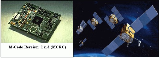
Active user equipment programs include the production of Miniaturized Airborne GPS Receiver (MAGR) 2000 in FY00 and FY01, followed by platform installations in FY01 and beyond; Defense Advanced GPS Receiver (DAGR) deliveries beginning in FY03; and M-code receiver deliveries beginning in FY07. All receivers produced after FY02 are to have the Selective Availability Anti-Spoofing module (SAASM) capability installed.
TEST & EVALUATION ACTIVITY
FY01 activity included continued test planning meetings, and the final staffing, coordination, and approval of the GPS Modernization TEMP in November 2001.
Future testing includes completing the Block IIR test, implementing the Block IIR-M (FY03) and IIF (FY06) test programs, and the evolution of the control segment. Full operational testing of the Block IIR portion of the GPS constellation will take place when seven to nine satellites are on orbit, and will assess IIR effectiveness and suitability against documented requirements (SORD). The assessment will also determine the efficacy of the cross-link problem fix. However, a series of operational assessments will be conducted in the interim, evaluating satellite functionality, control segment upgrades, and legacy and prototype user equipment.
The next round of IOT&E will occur when 24 operational Block IIR-M and Block IIF satellites are on-orbit and control segment software version 6 is declared operational. IOT&E will be a system-wide test of the space and control segments and legacy and future M-code capable user equipment. It is scheduled to take place in FY08-09.
TEST & EVALUATION ASSESSMENT
Ground testing and preliminary on-orbit testing indicate that the proposed solution to the Block IIR cross-link problem is being resolved satisfactorily. The six successfully launched Block IIR satellites are performing their navigation and timing mission without any reported problem and are expected to meet all navigation and timing requirements for the IIR system. However, it is still too early to report a final determination of the effectiveness and suitability of the entire series of IIR satellites.
Delays in developing and testing the GPS Operational Control Segment are DOT&E's chief concerns. Control software segment development continues to be a moderate to high-risk area with an ambitious schedule. Development of M-code capable user equipment lags behind the development of the space and control segments, and this may induce delays in testing the Block IIR-M and IIF systems, along with the attendant M-code and civil signal capabilities.
The planned test approach provided in the new version of the GPS TEMP (approved November 2001) is straightforward and well thought out. Extensive joint developmental/operational testing is planned to ensure early and adequate insight into the new capabilities planned for inclusion into the GPS mission; i.e., associated control segment software and M-code functionality, second and third civil signals, and signal protection for U.S. and allied forces.
DOT&E continues to advocate the testing of new and legacy GPS receivers as early in the program as possible. These receivers must be integrated into representative platforms (i.e., ships, aircraft, and land vehicles) and tested in operational environments. DOT&E is monitoring very closely the developmental and operational testing of the so-called ICD-compliant, Block IIA, IIR, IIR-M, and IIF compatible GPS cards that form the basis of the next generation of GPS user equipment. Full testing of these cards, and associated electronics, will not occur until M-code capable receivers are available (FY07 timeframe.) Before that time, backward compatibility and initial M-code performance of the new GPS cards must be tested in existing receivers, integrated into operational platforms.
DOT&E considers control segment software development as a moderate to high-risk area, with an ambitious schedule that will be difficult to meet. In the space segment arena, the M-code signal is not fully defined, and this uncertainty is beginning to impact development and test schedules. Resources should be brought to bear to ensure timely design and development of both control segment software and M-code signal generation on satellites.
Early operational evaluation/testing of integrated UE, including testing on an inverted range, must take place in the 2004-05 timeframe to ensure backward compatibility with existing UE and discover shortfalls that might exist in the design of M-code receivers.
|
NEWSLETTER
|
| Join the GlobalSecurity.org mailing list |
|
|
|