

DOT&E FY2000 Annual Report
NATIONAL POLAR-ORBITING OPERATIONAL ENVIRONMENTAL
SATELLITE SYSTEM (NPOESS)
 |
| Air Force ACAT ID Program | Prime Contractor | |
| Total Number of Systems: | 5 satellites | TBD |
| Total Program Cost (TY$): | $4.9B | |
| Average Unit Cost (TY$): | $985M | |
| MS II/III: | 2QFY02 | |
| First Launch: | 2008 |
SYSTEM DESCRIPTION & CONTRIBUTION TO JOINT VISION 2020
The National Polar-Orbiting Operational Environmental Satellite System (NPOESS) is a Tri-Agency program jointly administered by DoD, the Department of Commerce's National Oceanic and Atmospheric Administration (NOAA) and the National Aeronautics and Space Administration (NASA). The program is managed by an NPOESS Executive Committee through an Integrated Program Office, and is being acquired under U.S. Air Force acquisition authority. NPOESS will provide a national remote sensing capability to acquire and disseminate global and regional environmental data for a period of at least ten years after achieving initial operational capability.
For military users, NPOESS will provide an enduring capability to receive and disseminate global and regional meteorological, environmental, and associated data at varying update rates depending on military needs. These data will include, but are not limited to, cloud imagery, atmospheric temperature and moisture, and solar-geophysical data to support worldwide military operations. NPOESS will provide the warfighter with the information superiority needed to execute the dominant maneuver operational concept. NPOESS also supports precision engagement, enhancing our forces' ability to plan and execute air, land, and sea operations throughout a large spectrum of challenging environmental conditions and within the enemy's decision cycle.
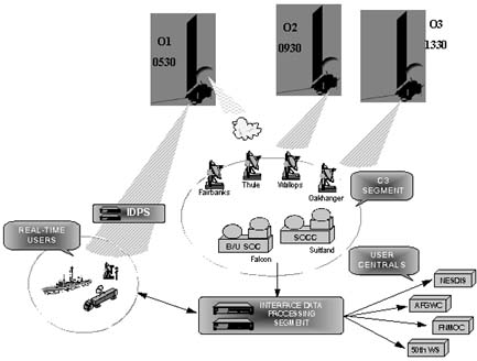
NPOESS contains the following segments:
- The Space segment, comprised of satellite platforms containing sensors and communications devices, will collect, store, and downlink data to the command, control, and communications C3 segment and users on the ground. The satellites will selectively download all data to ground stations as well as provide continuous downlink of data for receipt by worldwide deployed DoD field units.
- The Launch Support segment is comprised of launch facilities and support equipment. NPOESS is expected to operate in a sun-synchronous, near-polar orbit at approximately 833 km in altitude.
- The C3 segment includes all functions required for day-to-day state-of-health monitoring of all operating spacecraft, and supports the delivery of data to the designated primary terminals known as "Centrals."
- The Interface Data Processor (IDP) segment is comprised of data processing functions for two sub-components: the Centrals and the Field Terminals. Stored data will be delivered to the Centrals' Interface Data Processor component via the C3 segment. In addition, the spacecraft will provide real-time data directly to line of sight military Field Terminal components and surface receivers operated by worldwide weather services and other agencies.
BACKGROUND INFORMATION
The U.S. government currently operates and maintains two polar-orbiting meteorological satellite systems. The USAF operates the military's Defense Meteorological Satellite Program system, while NOAA operates the Polar-orbiting Operational Environmental Satellite (POES) system. To reduce the costs of acquiring and operating polar-orbiting satellites, the White House announced a decision to integrate the two weather satellite programs into a single converged system in May 1994.
NPOESS Milestone I occurred in FY97. The Program Definition/Risk-Reduction (PDRR) phase was structured around system architecture studies, sensor and algorithm development, and Pre-Total System Performance Responsibility (TSPR) contracts. During PDRR, multiple contracts were awarded for each higher risk sensor and/or suite of sensors. A single contractor for each payload is being selected after each sensor/suite Preliminary Design Review and Call for Improvement. A competitive Pre-TSPR award to two contractors occurred in FY00 (to TRW and Lockheed Martin) to address data processing risks and bring the program to a System Functional Review level of development prior to TSPR selection. Selection of the final TSPR contractor will occur shortly after Milestone II in FY02.
Planned European participation in NPOESS has been reduced. NPOESS had planned to fly a sub-set of its sensor packages on the European Meteorological Satellite Organization (EUMETSAT) Meteorological Operational Program-3 (METOP-3) satellite, which would have met NPOESS coverage and data refresh rate requirements at relatively low cost. EUMETSAT's decision to bulk buy METOP satellites 1 through 3 precludes sensor package incorporation. The Program Office has proposed a solution of acquiring and orbiting a third NPOESS satellite containing two critical NPOESS sensors in place of METOP-3 in order to meet DoD imagery refresh rate requirements. Availability of this third NPOESS satellite would be two years later than the previously planned METOP-3; the Program Office has also proposed re-phasing the DMSP launches to cover the METOP-3 gap until the third NPOESS orbit is available. This solution meets all user Key Performance Parameters at an additional net life cycle cost of $60 million.
TEST & EVALUATION AND RISK-REDUCTION ACTIVITY
T&E and risk-reduction activities in FY00 included a TEMP revision, Preliminary Design Review (PDR) on a critical NPOESS sensor suite, drafting of a Combined Test Force charter, and refinement of the OT concept.
The initial TEMP was approved in March 1997. During FY00, the TEMP was revised to reflect the program's 1999 re-baseline, which delayed delivery of the first satellite by one year to July 2008. The re-baseline also delayed and modified the pre-TSPR risk-reduction activities and delayed the EMD contract award date to FY02. The revised TEMP also addresses the T&E management structure through a Combined Test Force (CTF), updates and refines the test concept and test activities, and specifies required T&E assets and funding.
The NPOESS test concept includes T&E risk-reduction during PDRR, which consists of sensor design and algorithm testing utilizing a government developed and operated Integrated Weather Product Test Bed. This ensures that each selected sensor contractor has provided a design/algorithm combination that meets NPOESS technical requirements, and is responsive to user's operational requirements.
The OT concept includes an Operational Assessments (OA), combined DT and OT (DT/OT), and an end-to-end IOT&E of the military portions of the NPOESS system. Three OA's are planned: OA1 in FY01-02 in support of MSII; OA2 in FY04 in support of Critical Design Review; and OA3 in FY06 in support of fielding of the C3/IDP (Spell Out) segments. The OA's will be followed by a dedicated IOT&E in FY09 to support initial operational capability. To support early assessments, operational testing will augment field data with results from validated models, simulations, and hardware-in-the-loop test beds. Throughout the program, combined DT/OT will be used when appropriate to minimize the time required for dedicated IOT&E and to reduce the design risk by providing an operational perspective as early as possible in the acquisition process. During dedicated IOT&E, the operational testers will conduct testing on production-representative hardware and software, supplemented as required with data from validated and accredited modeling and simulation.
During EMD, a key risk-reduction activity is the NPOESS Preparatory Project (NPP). The NPP is a joint Integrated Program Office/NASA space flight of selected critical imager and sounding systems. This flight, scheduled for FY05, will provide NPOESS with a risk-reduction demonstration, and NASA with selected sensor data to provide continuity with current environmental and weather satellites. NPP activities will also include development of a ground C3/IDP segment with legacy to the operational system.
During FY00, as part of risk-reduction, a PDR was held on the Visible/IR Imager Radiometer Suite (VIIRS), one of five critical NPOESS sensor suites. Previous PDRs had been held on three other critical NPOESS sensor suites: (1) the Global Positioning System Occultation Sensor (GPSOS) in November 1998; (2) the Ozone/Mapper Profiler Suite (OMPS) in January 1999; and (3) the Cross-Track IR Sounder (CrIS) in April 1999. The remaining critical sensor suite, the Conical Microwave Imager Sounder (CMIS) will have its PDR in FY01. Two of these sensor suites, VIIRS and CrIS, along with NASA's Advanced Technology Microwave Sounder, are part of the NPP risk-reduction demonstration flight.
During FY00, agreement was reached on a charter to conduct, report, and provide oversight of NPOESS T&E activities to manage the complex Tri-agency T&E program. The charter provides for a Tri-agency CTF, composed of a multi-Service test force led by AFOTEC, and including NASA and NOAA operators and testers. The CTF is responsible for all testing, including DT&E, and will also conduct testing for NASA and NOAA requirements. The CTF will operate as the Operational Test Agency (OTA) for NPOESS, and will conform to Title 10 constraints on the use of development contractors. A sub-set of the CTF, known as the CTF Independent Council (CTF-IC), excludes contractors and the Integrated Program Office, and will be responsible for independent evaluation and assessment of test results. For purposes of assessing military effectiveness and suitability, DOT&E maintains the authority to approve the TEMP and operational test plans, and to provide an independent assessment to Congress.
TEST & EVALUATION ASSESSMENT
No assessment of operational effectiveness or suitability can be made at this time. NPOESS is still in the Program Definition/Risk-Reduction phase, only limited DT&E has been conducted, and no dedicated OT&E has been conducted on the program. DOT&E's current activities are concentrated on reviewing risk-reduction activities, helping to structure the test charter, developing the operational assessment plans and the TEMP, and ensuring that the program continues to evolve towards an operationally effective and suitable system.
FY00 NATIONAL POLAR-ORBITING OPERATIONAL ENVIRONMENTAL SATELLITE SYSTEM (NPOESS)
|
NEWSLETTER
|
| Join the GlobalSecurity.org mailing list |
|
|
|