

DOT&E FY2000 Annual Report
NAVSTAR GLOBAL POSITIONING SYSTEM (GPS)
 |
| Air Force ACAT ID Program | Prime Contractor | |
| Total Number of Satellites: | 65 | Block II, IIA - Rockwell |
| Total Program Cost (TY$): | $7,320M* | Block IIR - Lockheed Martin |
| Average Unit Cost (TY$): | $37.5M (Blk IIR)** | Block IIF - Boeing |
| Full-rate production: | 3QFY89 (Blk IIR) | Ground Segment (SPI) - Boeing |
**Does not include modernization
SYSTEM DESCRIPTION & CONTRIBUTION TO JOINT VISION 2020
The NAVSTAR Global Positioning System (GPS) is a 24-satellite constellation that provides highly accurate, real-time, all weather, passive, common-reference grid position and time information to military and civilian users worldwide. GPS enables the military forces to precisely determine their position, velocity, and time to: (1) enhance command and control and coordinate battle tactics and support; (2) engage in strategic and tactical warfare; (3) maneuver efficiently on the battlefield; (4) provide accurate and timely fire support; and (5) facilitate combat service support operations. In addition, knowledge of exact position and time is essential to reconnaissance and intelligence missions. GPS provides the precision, velocity, and time element of information superiority, and serves as the cornerstone of the warfighter's ability to execute the Joint Vision 2020 concept of precision engagement.
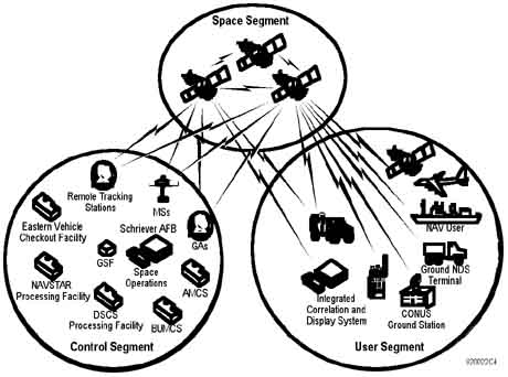
GPS is an Air Force-managed Joint Service program and comprises three segments: space, control, and user equipment. The space segment consists of 24 satellites in semi-synchronous orbits around the earth. The original Block I satellites were replaced with Block II/IIA satellites. Currently, Block II/IIA satellites are being replaced with Block IIR as the II/IIA satellites fail on-orbit. The control segment consists of a master control station, four ground antennas, a pre-launch capability station, and five geographically dispersed monitoring stations. The control segment monitors satellite downlink signals and uploads corrections to diminish errors broadcast to users. The user segment consists of numerous forms of GPS receivers that use satellite downlink signals to determine position, velocity, and precise time. These receivers are hosted on a multitude of platforms and are classified into three general categories: high-dynamic sets (5+ channels); medium-dynamic sets (2 channels); and low-dynamic sets (usually single channel). Primarily the Air Force and Navy use the 5-channel sets on aircraft, ships, and submarines. The 2-channel sets are used mainly by the Army in heliborne configurations. The single-channel sets are generally used in hand-held applications.
BACKGROUND INFORMATION
DoD approved the NAVSTAR GPS program in December 1973. Full-scale development began in June 1979. By 1985, the Joint Program Office had launched ten Block I satellites and developed the associated ground-control system software to support system test and checkout. The first production satellite launched successfully in February 1989. The Block I satellites were followed by 27 Block II/IIA satellite launches. The initial operational capability, which included the control segment, was declared on December 8, 1993.
The first Block IIR satellite was destroyed during launch as a result of a Delta booster explosion on January 17, 1997. The first successful launch of a Block IIR satellite occurred on July 22, 1997. Currently, there are three Block IIR satellites on-orbit. The GPS IIR satellites provide the same functionality as earlier satellites, with added capabilities in two-way ranging and requiring less human interfacing for on-orbit operations. There are 19 additional Block IIR launches planned, with as many as 12 of these being the modernized or Block IIR-M version. The first Block IIR-M satellite launch is planned for FY03. The IIR-M capabilities add developmental military M-code on the L1 and L2 signals and civil use C/A code on the L2 signal. Block IIF satellites are also under development, with the first IIF satellite launch planned for FY06. The Block IIF satellites are functionally equivalent to the IIR/IIR-M satellites, plus completely operational M-code on L1 and L2, and a new civil signal, designated L5, operating at 1,176 MHz.
GPS user equipment development began in June 1979, with receiver testing (using Block I satellites) in a variety of land, sea, and air vehicles. Since then, numerous versions of single-, 2-, and 5-channel receivers have undergone development and fielding. GPS user equipment achieved full-rate production approval in January 1992. Full operational capability was declared in November 1995, after completion of Phase III IOT&E.
Active user equipment programs include the production of Miniaturized Airborne GPS Receiver (MAGR) 2000 in FY00 and FY01, followed by platform installations in FY01 and beyond; Defense Advanced GPS Receiver deliveries beginning in FY03; and M-code receiver deliveries beginning in FY07. All receivers produced after FY02 are to have the SAASM capability installed.
TEST & EVALUATION ACTIVITY
Space and control segment testing occurred in three phases. Phase I IOT&E was conducted from 1989-1990; Phase II IOT&E from 1990-1992; and Phase III from 1992-1994. Each test phase was successful and progressively led to an approved final operational capability, with a complete 24-satellite configuration. The Block IIA satellite constellation and ground system completed all operational test activities in prior years and are fully operational.
Testing and procurement of GPS user equipment began in the late 1980s and early 1990s with the 1-channel Manpack receiver and the 3A (airborne) and 3S (ships) receivers. The Manpack was replaced with the commercially developed SLGR and the advent of PLGR in 1993. A 2-channel receiver was also developed and tested in this timeframe, mostly for heliborne applications. The commercially inspired non-developmental item (NDI) MAGR was installed in aircraft in the early 1990s as an answer to space and weight constraints in many aircraft platforms. The NDI-procured Embedded GPS/INS receiver, the so-called EGI card, has also been installed extensively on platforms. Typically, NDI receivers are not subjected to the same rigorous test activity that predecessor receiver programs experienced.
An operational assessment of the first Block IIR satellite was conducted in July 1998. Although the IIR satellite met all navigation and timing requirements, a significant problem was found with the improved cross-link capabilities. The cross-link system sensed spurious radio frequency interference that inhibited completion of system tasks. An interim fix for the problem has been incorporated on the second and third IIR satellites, and a more robust resolution to the problem is being applied to the remaining Block IIR/IIR-M satellite family.
Future testing consists of completing the Block IIR test, implementing the Block IIR-M (FY03) and IIF (FY06) test programs, and the evolution of the control segment. Operational testing of the Block IIR portion of the GPS constellation will take place when seven to nine satellites are on-orbit, and will assess IIR effectiveness and suitability against documented requirements (SORD). The assessment will also determine the efficacy of the cross-link problem fix.
The modernized Block IIR satellites (M-code capable), designated IIR-M, are currently in production and scheduled for first launch in FY03. IIR-M capabilities to provide NAVWAR protection, backward compatibility with legacy receivers, and a new civil signal on L2 will be assessed when 1 to 3 IIR-M satellites are on-orbit. Control segment software version 5 will be tested in conjunction with Block IIR-M satellite tests.
The follow-on Block IIF satellites are scheduled for first launch in FY06. These satellites will also be M-code capable, and besides providing the civil signal on L2, will also provide a new civil signal on the L5 frequency. Testing of the Block IIF satellites will be performed along with Block IIR-M satellites, and will be done in conjunction with software tests for control segment versions 6 and 7.
IOT&E will occur when 24 operational Block IIR-M and Block IIF satellites are on-orbit and control segment software version 7 is operational. IOT&E will be a system-wide test of the space and control segments and legacy and future M-code capable user equipment. It is scheduled to take place in FY09-10.
TEST & EVALUATION ASSESSMENT
Ground testing and preliminary on-orbit testing indicates that the proposed solution to the Block IIR cross-link problem is being resolved satisfactorily. However, it is still too early to report a final determination of the effectiveness and suitability of the IIR satellites. The three successfully launched Block IIR satellites are performing their navigation and timing mission without any reported problems, and are expected to meet all navigation and timing requirements for the IIR system. Based on the history of the GPS program, the results of the operational assessment, and the efforts to correct the interference problem, DOT&E believes that the Joint Program Office is progressing satisfactorily toward fielding an effective and suitable space segment.
Continuing problems in the GPS Operational Control Segment are the basis of DOT&E's chief concern. Control software segment development continues to be a moderate to high-risk area with an ambitious schedule. There have been problems in incorporating the Government's Single Prime Initiative (one contractor for both space and control segments). A six-month delay occurred because new startup funds were not authorized until August 15, 2000. This lack of funding has seriously impaired system development and test schedules, which were already risky, with no margin to spare. Additionally, the contractor developing the replacement Operational Control System (version 3/4) continues to experience problems. Probable delays are expected in implementing the Block IIR-M and IIF systems, with the attendant M-code and civil signal capabilities. Development of M-code capable user equipment lags behind the development of the space and control segments, and this may also induce delays in testing.
The planned test approach provided in the new version of the GPS TEMP is straightforward and well thought out. Extensive joint developmental/operational testing is planned to ensure early and adequate insight into the new capabilities planned for inclusion into the GPS mission; i.e., second and third civil signals, and signal protection for U.S. and allied forces. The GPS TEMP has been updated to cover test activities for the associated control segment software and M-code functionality. Final OSD approval is expected in early FY01.
One shortfall that DOT&E has identified in the TEMP concerns the operational testing of ICD-compliant GPS cards that form the basis of next-generation UE. These new cards are to be Block IIA, IIR, IIR-M, and IIF compatible, and integrated into existing and yet-to-be-developed UE. The current test plans do not call for any operational testing of this UE in the near term other than in a static environment. Full testing of these cards, and associated electronics, will not occur until the as yet fully defined M-code capable receivers are available in the '07 timeframe. Before that time, we believe that backward compatibility and initial M-code performance of the new GPS cards must be tested in existing receivers integrated into operational platforms.
DOT&E continues to advocate the testing of this new UE, integrated into representative platforms (i.e., ships, aircraft, and land vehicles) as early in the program as possible. This testing could be conducted as operational assessments, followed by an end-to-end system test (IOT&E) in the 2009-2010 timeframe.
RECOMMENDATIONS
DOT&E considers control segment software development as a moderate to high-risk area, with an ambitious schedule that will be difficult to meet. The architecture has not been fully defined, and there are some problems with the implementation of the Single Prime Initiative. In the space segment arena, the M-code signal is not fully defined, and this uncertainty is beginning to impact development and test schedules. Resources should be brought to bear to ensure timely design and development of both control segment software and M-code signal generation on satellites. We will monitor this activity with respect to impacts on the testing schedule.
Early operational evaluation/testing of integrated UE, including testing on an inverted range, must take place in the 2004-05 timeframe to ensure backward compatibility with existing UE and discover shortfalls that might exist in the design of M-code receivers.FY00 NAVSTAR GLOBAL POSITIONING SYSTEM (GPS)
|
NEWSLETTER
|
| Join the GlobalSecurity.org mailing list |
|
|
|