

FM 6-20-10: Tactics, Techniques, and Procedures for The Targeting Process
APPENDIX K
COMMON DATUM
For joint agencies to proper/y coordinate targeting functions, they must be able to exchange information by using a common frame of reference regarding the area of operations. A small detail that has tremendous implications supporting this common reference, especially if overlooked, is ensuring planners and operators use the correct datum.
During the first days of Operation Desert Storm (ODS), the Air Force reported that B-52 raids consistently fell short of the target. The target locator was on a different datum from the B-52 navigation system. After application of datum shifts, B-52 missions were successful. In some cases, target coordinates determined by observers were based on a different map datum than that used by the fire support planners and execution systems. Location variances exceeded 700 meters. In other ODS examples, a GPS receiver position was compared to a paper map position and in many cases the positions varied by hundreds of meters--the primary reason was different datums. In another example, troops deploying to Somalia found the maps available were a mix of Russian maps found in Gauss Kruger (GK) and World Geodetic System (WGS) 72.
DATUM AND PROJECTION AWARENESS
Personnel working in any organization which exchanges information regarding position locations must be aware of the need for using a common datum. In the past this was not viewed as critical because weapons technology and employment doctrine did not require highly accurate positions. The possibility of deployment to many new foreign locations, where the only maps are on local datums and foreign projections, make precise coordinates vital to mission success. The problem is even more critical with the advent of growing technology (for example, global positioning system [GPS], ATACMS, tactical land attack missile system [TLAMS], and so forth). Ignoring the map datum could result in fratricide or gross target location errors.
A datum is the mathematical model of the earth used to calculate position coordinates on any map, chart, or survey system. Many countries use their own datum( s) when they make their maps and survey. The local datums may produce coordinates which vary greatly from datums used by US forces. Even within the US Department of Defense, different datums are in use or have been used.
Presently there are more than 1,000 datums in use. The DMA is concerned with only 200 of these which are found on paper maps, digital mapping products, and other products provided to the user. As datums are shifted to a common grid, the change in the location of a unit may be more than 1,000 meters. There are different datums for both horizontal and vertical reference. Most vertical datums use mean sea level for elevation, but they may use any of over a hundred different horizontal position datums. DMA is reducing the number of datums used for their products. As map products are updated, they will be updated with standard datums and ellipsoids. Do not mix old and new products. The DMA decided to use WGS 84 in most of the world. During transition, some paper products will not match digital products.
There can be several error possibilities in air ground operations if multiple datums are used. A few are listed below.
- Friendly position location errors.
- Enemy target location errors.
- CSAR location errors.
- Navigation aid (NAVAID) use.
- Aircraft vectoring errors.
- Airdrop errors.
- Airspace control measure errors.
- Air defense errors.
DATUM USE
The JFC must identify which datum information is to be used within the joint force for exchange of position information. Subordinate personnel must know the answer to these questions:
- What is the operational datum?
- On what datum are the target coordinates?
- On what datum are the position coordinates?
- On what datum are fire control systems?
- On what datum are the current operational maps?
CHECKING DATUM AND CONVERTING COORDINATES
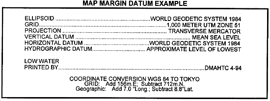
Datums can be checked. All maps and products that the DMA distributes have the datum printed somewhere in the margin. The figure below is an example of typical datum information provided in the margin of a map. The BCE must procure DMA-published software called MADTRAN, which can convert coordinates from latitude and longitude to universal transverse mercator (UTM) or MGRS, and the reverse. It can also transform coordinates between WGS 84 and over a hundred other datums. MADTRAN 4.0, the current version, comes with instructions and will work on any IBM PC compatible computer with a 5 1/4 inch floppy drive. It can be ordered from wherever the user procures DMA products by using stock number MADTRANIBMPC.
|
NEWSLETTER
|
| Join the GlobalSecurity.org mailing list |
|
|
|