


Hurricane Isabel
Major Hurricane Isabel was a dangerous Category 4 Hurricane. This hurricane was a fast mover and maintained high winds very far inland, at category 3 intensity on landfall. Landfall along the US mid-Atlantic coast somewhere between North Carolina and New Jersey between 18-19 September appeared more and more likely. Global model consensus continues to target DelMarVa peninsula between Virginia Capes to Delaware Bay. There continues to be excellent consistent grouping targeting this area. This to the right of current National Hurricane Center (NHC) track which takes Isabel into Outer Banks and northward through Pamlico Sound on Thursday to northwest of the District of Colombia early Friday and into central Pennsylvania.
Forecasters said Hurricane Isabel would weaken slightly over the following several days, but residents of the US East Coast should prepare for a major storm, when Isabel strikes the region later this week. With winds of 240-kilometers an hour, Hurricane Isabel is the strongest Atlantic Hurricane to develop so far this year. On the Saffir Simpson scale that measures hurricane strength, Isabel is fl8uctuating between a Category-Four storm and the maximum Category Five rating. Isabel is now in the Atlantic Ocean, moving west-northwest at about 16-kilometers an hour. The storm is expected to weaken as it moves over cooler water, but when it strikes land later this week it could be the strongest hurricane to strike the United States in more than a decade.
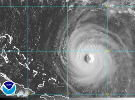
As of 14 September 2003, Isabel was moving toward the west-northwest near 13 mph [20 km/hr] and this general motion was expected to continue for the next 24 hours. Maximum sustained winds recently reported by NOAA and Air Force Reserve hurricane hunter aircraft remained near 155 mph [250 km/hr] with higher gusts. This makes Isabel a strong category 4 hurricane on the Saffir-Simpson hurricane scale, and just below category 5 intensity. Hurricane force winds extend outward up to 100 miles [160 km] from the center and tropical storm force winds extend outward up to 200 miles [325 km].
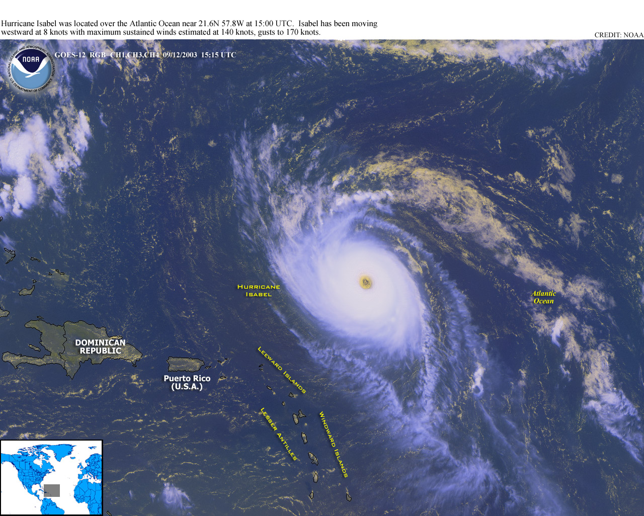
The NOAA National Hurricane Center in Miami, FL, reported that at 11 a.m. EDT on 14 September the center of major Hurricane Isabel was located near latitude 23.7 north, longitude 66.3 west or about 370 miles east-northeast of the Turks and Caicos Islands. Isabel is moving toward the west-northwest near 12 mph, and this general motion was expected to continue for the next 24 hours. Hurricane force winds extend outward up to 85 miles from the center, and tropical storm force winds extend outward up to 200 miles.
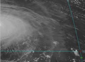
The eye remained very distinct and circular, albeit with an unusually large 40 nmi diameter. The intensity had only been decreased slightly down to 135 kt since the eye has become embedded directly in the center of the central deep convection. Such perfect symmetry oftentimes indicates a cyclone stronger than satellite the estimates.
The afternoon plethora of recon wind and pressure data on 14 September 2003 indicate that Isabel remained barely below category 5 intensity. Air Force Reserve hurricane hunters measured 700 mb flight-level winds of 150 kt -- or 135 kt surface equivalent -- in the northeast quadrant of the eyewall. A NOAA hurricane hunter dropsonde report indicated 171 kt average winds in the lower 150 meters, or 139 surface wind equivalent. Based on this information, Isabel was maintained at 135 kt. The outflow pattern remained very impressive and has continued to expand.
There remained some uncertainty on where the exact landfall of Isabel could occur since the developing central US trough could still deepen and dig more southward than the models were indicating. This could induce a more northward motion and result in landfall farther up the US east coast. But as in the previous several model runs, a large and very strong north-south oriented ridge was forecast to remain east of Isabel and prevent the hurricane from recurving northeastward. Only minor fluctuations in intensity were expected for the next couple of days as Isabel was forecast to move over sightly warmer water and remain in a favorable upper-level outflow pattern. Isabel will be moving over the warm Gulfstream offshore North Carolina just prior to landfall.
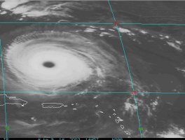
By the morning of 15 September satellite imagery indicated that the inner core structure continued to break down with a less well-defined eye in visible imagery. Eyewall convection had become asymmetric and fragmented...and the overall convective structure was now more banded than it was over the past couple of days. The latest Dvorak satellite intensity estimates are 115 kt and the advisory intensity was lowered to 120 kt. Model guidance was in excellent agreement on the track, and very little change has been made to the official forecast track which is very close to the GFDL / UKMET / NOGAPS / GFS model consensus. Although there has been some restriction of the outflow in the southwest quadrant the current weakening on 15 September may be more a result of less favorable environmental thermodynamics. There will be plenty of warm water under the hurricane until cooler shelf waters are encountered right along the coastline. One key to the ultimate landfall intensity will be the evolution of an upper-level trough that could enhance the outflow and reduce the shear prior to landfall if it digs as sharply as forecast by the GFS. With this in mind Isabel could still be a major hurricane at landfall.
		FORECAST VALID 18/1200Z
		LOCATION 34.5N  75.5W
		MAX WIND 110 KT...GUSTS 135 KT.
		50 KT...150NE 150SE  75SW  75NW.
		34 KT...225NE 225SE 125SW 125NW.
		OUTLOOK VALID 19/1200Z
		LOCATION 40.0N  78.0W...INLAND
		MAX WIND  60 KT...GUSTS  75 KT.
Hurricane Basics
Hurricanes need warm tropical oceans, moisture and light winds above them. If the right conditions last long enough, a hurricane can produce violent winds, incredible waves, torrential rains and floods. Hurricanes rotate in a counterclockwise direction around an "eye." Hurricanes have winds at least 74 miles per hour. September is usually the most active month in the six-month Atlantic and Caribbean hurricane season that ends on November 30th.
The center, or eye, of a hurricane is relatively calm with sinking air, light winds and few clouds. The most violent winds and rain take place in the eyewall, the ring of thunderstorms immediately surrounding the eye. At the top of the eyewall (about 50,000 feet), most of the air is propelled outward, increasing the air's upward motion. Some of the air, however, moves inward and sinks into the eye, creating a cloud-free area.
The intensity of a landfalling hurricane is expressed in terms of categories that relate wind speeds and potential damage. According to the Saffir-Simpson Hurricane Scale, a Category 1 hurricane has lighter winds compared to storms in higher categories. A Category 4 hurricane would have winds between 131 and 155 mph and, on the average, would usually be expected to cause 100 times the damage of the Category 1 storm. Depending on circumstances, less intense storms may still be strong enough to produce damage, particularly in areas that have not prepared in advance.
The strongest winds usually occur in the right side of the eyewall of the hurricane. Wind speed usually decreases significantly within 12 hours after landfall. Nonetheless, winds can stay above hurricane strength well inland. Hurricane Hugo (1989), for example, battered Charlotte, North Carolina (which is 175 miles inland) with gusts to nearly 100 mph.
The Inland High Wind Model can be used by emergency managers to estimate how far inland strong winds extend. The inland wind estimates can only be made shortly before landfall when the windfield forecast errors are relatively small. This information is most useful in the decision-making process to decide which people might be most vulnerable to high winds at inland locations.
As winds increase, pressure against objects is added at a disproportionate rate. Pressure against a wall mounts with the square of windspeed so that a threefold increase in windspeed gives a nine-fold increase in pressure. Thus, a 25 mph wind causes about 1.6 pounds of pressure per square foot. A four by eight sheet of plywood will be pushed by a weight of 50 pounds. In 75 mph winds, that force becomes 450 pounds, and in 125 mph winds, it becomes 1,250 pounds. For some structures, this force is enough to cause failure.
Heavy rains and ocean waters brought ashore by strong winds can cause flooding in excess of 50 cm (20 in) over a 24 hour period. The runoff systems in many cities are unable to handle such an increase in water because of the gentle topography in many of the coastal areas where hurricanes occur.
Preparation
As major hurricane Isabel continues to move west northwest toward the east coast of the United States, now is a good time to review and update your family disaster plan. Part of your family disaster plan should be preparing in case a hurricane threatens your area. Some activities which you still have time to complete include knowing the hurricane risks in your area such as whether you live in a potential flood zone, learning safe routes inland from coastal areas, finding out where official shelters are located, trimming trees and shrubbery, clearing loose and clogged rain spouts and gutters and determining where to move your boat in an emergency.
HURRICANE WATCH: Hurricane conditions pose a possible threat to your area. In especially vulnerable areas, early evacuation may be necessary when a Watch is issued. Otherwise you should review hurricane safety procedures and make preparations. Listen to NOAA Weather Radio and commercial radio and television for the latest information and instructions for your location.
When your area receives a hurricane watch:
- Listen to a battery-operated radio or television for hurricane progress reports.
- Check emergency supplies.
- Fuel car.
- Bring in outdoor objects such as lawn furniture, toys, and garden tools and anchor objects that cannot be brought inside.
- Secure buildings by closing and boarding up windows. Remove outside antennas.
- Turn refrigerator and freezer to coldest settings. Open only when absolutely necessary and close quickly.
- Store drinking water in jugs, bottles, and cooking utensils.
- Review evacuation plan.
- Moor boat securely or move it to a designated safe place. Use rope or chain to secure boat to trailer. Use tiedowns to anchor trailer to the ground or house.
HURRICANE WARNING: Hurricane conditions are expected in your area within 24 hours. Areas subject to storm surge or tides should be evacuated as well as areas which could be isolated by flood waters. Follow the instructions of local officials. You will not be asked to leave your home unless your life is threatened.
When your area receives a hurricane warning:
- Leave low-lying areas.
- Moore your boat securely or evacuate it.
- Protect your windows with boards, shutters, or tape.
- Secure outdoor objects or bring them indoors.
- Fuel your car.
- Stay at home if it is sturdy and on high ground.
- Leave mobile homes for more substantial shelter.
- Stay indoors during the hurricane.
- If power is lost, turn off major appliances to reduce power "surge" when electricity is restored.
The Institute for Business & Home Safety (IBHS) says shopping early can help avoid supply shortages and long lines. IBHS recommends taking these three steps now:
- Clean your yard. Remove anything that will become flying debris, including dead tree limbs and broken fencing. If the storm gets closer, bring lawn furniture and garbage cans inside.
- Protect your windows. If you need to protect your windows and glass doors, get plywood panels no less than 7/16" thick. These panels must be properly fastened, with ring shank nails for wood frame houses or permanent anchors and bolts in masonry. Check with your local home improvement store for installation techniques.
- Reinforce your garage door. Your garage door is your home's largest single opening, next to your roof, making it vulnerable to high wind. Temporary center supports can be bought at home improvement centers or from the manufacturer and attached when severe weather threatens.
One of the most important parts of your family disaster plan is the preparation of a disaster supplies kit. This kit should include the following materials
- a three day supply of water with one gallon per person per day
- food that will not spoil
- Nonelectric can opener
- emergency cooking equipment
- one change of clothing and sturdy shoes per person
- one blanket and sleeping bag per person
- work gloves
- emergency tools [a wrench and other basic tools]
- a battery powered NOAA weather radio and a portable radio
- flashlights with extra batteries
- portable lanterns
- fresh batteries for each piece of equipment
- a first aid kit
- prescription medicines
- extra car and house keys
- extra eyeglasses
- any special items for infant elderly or disabled family members
- credit cards and cash
- important documents, including insurance policies
- Books to read while waiting
A hurricane causes sea level to rise above normal tidal heights, with giant wind-driven waves and strong, unpredictable currents. These are the storm's worst killers.
- Know your property's elevation above mean sea level.
- Have a safe evacuation route planned.
- Learn the storm surge history for your area.
Tornadoes spawned by hurricanes are extremely dangerous. When a hurricane approaches, listen for tornado watches and warnings, and be ready to take immediate shelter.
Become familiar with your community's disaster preparedness plans and create a family plan. Identify escape routes from your home and neighborhood and designate an emergency meeting place for your family to reunite if you become separated. Also establish a contact point to communicate with concerned relatives.
If a hurricane threatens, follow weather and news reports so you know how much danger you're facing. Obey evacuation orders from local authorities.
REMEMBER: Latest storm-related information will be available on NOAA Weather Radio and commercial radio and television. Do not tie up telephone lines by calling local officials or the National Weather Service. Listen carefully to broadcasters serving your immediate area.
| Hurricane Isabel |
| Click on the small image to view a larger version |
IR Loop |
IR Loop |
Real Time GOES Imagery - Floater Visible Loop |

This close-up view of the eye of Hurricane Isabel was taken by one of the Expedition 7 crewmembers onboard the International Space Station (ISS). At the time this photo was taken, Isabel had reformed to a Category 5 storm, packing winds of 160 miles per hour. This observation was made on September 13, 2003 by Expedition Seven crew members aboard the Space Station. |

This view of Hurricane Isabel was taken by one of the Expedition 7 crewmembers onboard the International Space Station (ISS). At the time this photo was taken, Isabel had reformed to a Category 5 storm, packing winds of 160 miles per hour.This observation was made on September 13, 2003 by Expedition Seven crew members aboard the Space Station. |

|
|

|
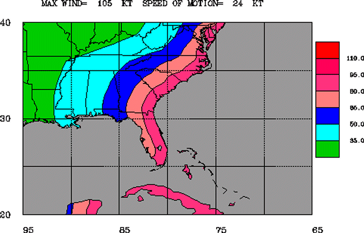
The inland wind model applies a simple two parameter decay equation to the hurricane wind field at landfall to estimate the maximum sustained surface wind as a storm moves inland. |
The black line and dots show the National Hurricane Center (NHC) forecast track of the center at the times indicated. NHC forecast tracks of the center can be in error; average areas of uncertainty for the first 3 days of the forecast track are shown by the solid white area, while the area of uncertainty for the days 4 and 5 portion of the forecast is shown by the white stippled area.

14 September forecast 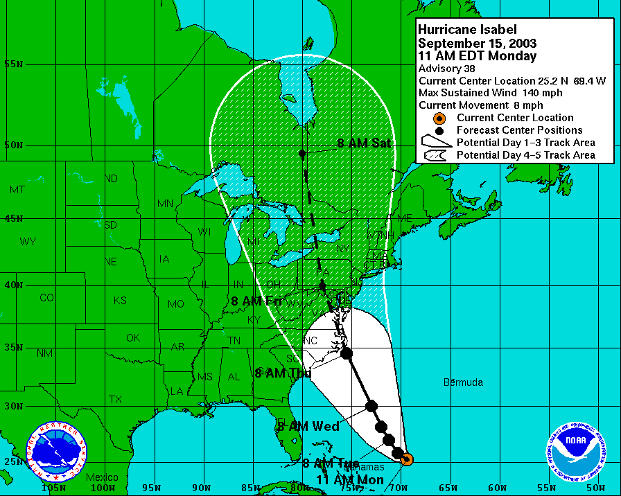
15 September AM forecast 
15 September PM forecast |
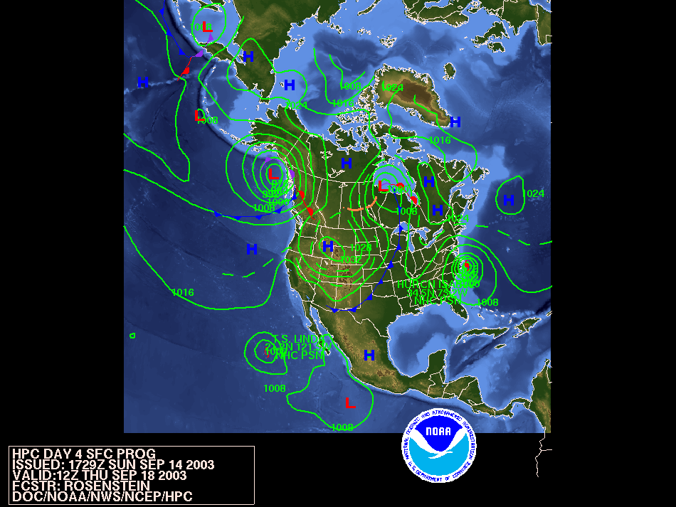
Thursday 18 September |
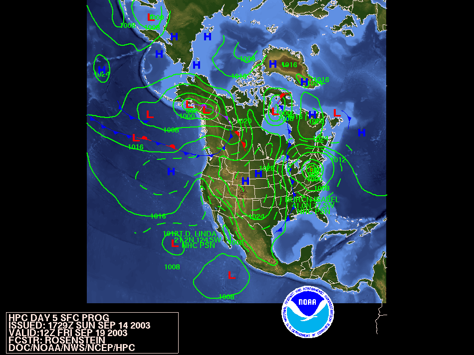
Friday 19 September |
|
NEWSLETTER
|
| Join the GlobalSecurity.org mailing list |
|
|
|