
Great Northeast Power Blackout of 2003
| DMSP Imagery of the Great Northeast Power Blackout of 2003 | |
| Click on the small image to view a larger version | |
Click here for a Before and After Comparative Overview of the Greater New York City Area |
|

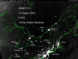
DMSP satellite image of the Northeastern United States approximately 20 hours before the blackout |
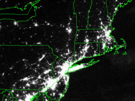
DMSP satellite image of the Northeastern United States approximately 7 hours after the blackout |

Click here for a Before and After Comparative Overview of the Images Above |
|
 DMSP satellite image of the Northeastern United States taken on Aug. 13, 2003, at 9:21 p.m. EDT
|
 DMSP satellite image of the Northeastern United States taken on Aug. 14, 2003, at 9:03 p.m. EDT
|
|
Click here for a Before and After Comparative Overview of the Images Above |
|
 Annotated DMSP satellite image of the Northeastern United States approximately 20 hours before the blackout
|
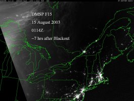
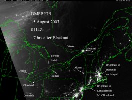 Annotated DMSP satellite image of the Northeastern United States approximately 7 hours after the blackout. The cities of Ottawa, Toronto, Detroit, Cleveland, Columbus and Buffalo have virtually disappeared, while the Greater New York City area is much darker!
|
|
NEWSLETTER
|
| Join the GlobalSecurity.org mailing list |
|
|
|